
SENSOR
DATA PUBLICATION ON THE WEB
FOR SCIENTIFIC APPLICATIONS
Gilberto Zonta Pastorello Jr., Luiz Gomes Jr., Claudia Bauzer Medeiros
Institute of Computing, UNICAMP, Av Albert Einstein, 1251 Campinas, SP, Brazil
Andr
´
e Santanch
`
e
DCEC – UNIFACS, Av Cardeal da Silva, 747 Salvador, BA, Brazil
Keywords:
Data publication on the Web, Web services standards, Scientific data, Sensor data.
Abstract:
This paper considers the problems of sensor data publication, taking advantage of research on components and
Web service standards. Sensor data is widely used in scientific experiments – e.g., for model validation, envi-
ronment monitoring, and calibrating running applications. Heterogeneity in sensing devices hamper effective
use of their data, requiring new solutions for publication mechanisms. Our solution is based on applying a spe-
cific component technology, Digital Content Component (DCC), which is capable of uniformly encapsulating
data and software. Sensor data publication is tackled by extending DCCs to comply with geospatial standards
for Web services from OGC (Open Geospatial Consortium). Using this approach, Web services can be im-
plemented by DCCs, with publication of sensor data following standards. Furthermore, this solution allows
client applications to request the execution of pre-processing functions before data is published. The approach
enables scientists to share, find, process and access geospatial sensor data in a flexible and homogeneous
manner.
1 INTRODUCTION
Sensors are fast becoming one of the main data
providers for scientific applications. A given set of
sensors may provide data to meet the needs of dis-
tinct applications – e.g., rainfall and temperature sen-
sors may be used by researchers in environmental
planning, habitat monitoring or epidemiology. How-
ever, each application domain – and each application
within a domain – will require distinct kinds of data
granularity and sampling. So, the question we answer
is the following: how to devise a solution to the prob-
lem of sensor data publication, to support homoge-
neous access mechanisms to geospatial sensor based
data from heterogeneous sources.
Our solution is based on a specific component
technology, Digital Content Components (DCCs),
which we extended to comply with geospatial Web
service standards from OGC (Open Geospatial Con-
sortium). DCCs are capable of uniformly encapsulat-
ing data and software, and are annotated with meta-
data and references to ontologies, following Semantic
Web standards. We use them to encapsulate access to
sensing data, homogeneously integrating them into a
single framework. DCCs provide basic data manip-
ulation functions, and can be composed into arbitrar-
ily complex procedures. We use these functions to
propose an extension to the OGC standards and pro-
ceed to show how to use DCCs to implement these
extended standards.
We use a running example based on epidemics
monitoring of dengue fever. It is caused by a virus
and is transmitted to humans by the Aedes aegypti
mosquito. Efforts to monitor dengue epidemics re-
quire combining geospatial data such as registered
disease cases, geographical and demographic charac-
teristics of the population, environmental data that is
known to affect disease spread (e.g., rainfall or tem-
perature), and locations where the mosquito is found.
The acquisition and access to such environmental
readings for experimental research is an open issue.
Our work contributes towards solving these problems.
The rest of the paper is organized as follows. Sec-
tion 2 presents the basics of the DCC technology and
explains the encapsulation of resources into DCCs.
Section 3 describes our proposal for multi-level in-
137
Zonta Pastorello Jr. G., Gomes Jr. L., Bauzer Medeiros C. and Santanchè A. (2008).
SENSOR DATA PUBLICATION ON THE WEB FOR SCIENTIFIC APPLICATIONS.
In Proceedings of the Fourth International Conference on Web Information Systems and Technologies, pages 137-142
DOI: 10.5220/0001515301370142
Copyright
c
SciTePress
tegration of sensor data Web publication. Section 4
discusses implementation issues. Section 5 considers
related efforts. Section 6 presents concluding remarks
and ongoing work.
2 DCCS AND RESOURCE
ENCAPSULATION
This section briefly presents DCCs (section 2.1) and
explains how we apply them to homogeneously en-
capsulate three kinds of resources: data, data sources
(e.g., databases and sensors), and software.
2.1 DCC Basics
A Digital Content Component (DCC) is a unit of con-
tent and/or process reuse, which can be employed to
design complex digital artifacts. It can be seen as dig-
ital content (data or software) encapsulated into a se-
mantic description structure. It is comprised of four
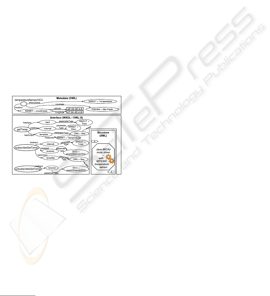
sections (Figure 1):
Figure 1: A DCC for sensor access.
(1) the content itself (data or code, or another DCC),
in its original format. In the example, the content is
a driver for communicating and gathering data from a
MICAz
1
sensor;
(2) the declaration, in XML, of a structure that defines
how DCC internal elements relate to each other (here,
delimitating the object code of the sensor’s driver);
(3) specification of an interface, using adapted ver-
sions of WSDL and OWL-S – e.g.,
getTemp
and
subscribeGetTemp
operations;
(4) metadata to describe functionality, applicability,
etc., using OWL (the DCC is declared as belong-
ing to class
TemperatureSensorDCC
and located at
longitude
and
latitude
specified).
1
www.xbow.com/Products/productdetails.aspx?sid=101
Interface and metadata are linked to ontology terms
– e.g., input parameters of the
getTemp
operation are
timestamps defined by the “Time” concept of NASA’s
SWEET (Raskin and Pan, 2003) ontology.
There are two main kinds of DCC – process and
passive. The first encapsulates any kind of process de-
scription, and Passive DCCs consist of any other kind
of content (e.g., a text or video file). See (Santanch
`
e
et al., 2007) for details.
2.2 Encapsulation of Data (Access and
Manipulation)
We encapsulate data withing PassiveDCCs and sens-
ing sources in ProcessDCCs. DCCs can be used
to homogeneously publish any kind of sensor gen-
erated data, be it static and/or streamed data (Pa-
storello Jr et al., 2007) . A satellite image, or a
file containing a temporal series of temperature data,
are typical examples of static data, while continu-
ous temperature reading transmissions are an exam-
ple of streamed data. These DCCs are annotated us-
ing ontology terms such as data type, the physical
phenomenon being measured (temperature, solar ra-
diation, etc), the geographical location of the reading
(e.g., GPS-provided). See (Pastorello Jr et al., 2007)
for more details on data encapsulation.
The number of sensors encapsulated within a Pro-
cessDCC depends only upon the implementation of
the sensor driver (as the MICAz driver in Figure 1).
A sensor network, for instance, can be encapsulated
by a DCC with a driver that communicates with the
network’s access point.
Manipulation of sensor data can occur in two lev-
els: within a sensor or a network (signal processing,
in-network fusion, etc) or externally (filtering data
by region, fusion of heterogeneous water tempera-
ture sensors, etc). External processing, sometimes
called post-processing, is usually application oriented
– e.g., summarization of temperature readings per re-
gion and time period for a dengue spread simulation.
3 SENSOR DATA PUBLICATION
In most cases, sensor data is georeferenced. This
makes it possible to employ general-use geospatial
standards and services for sensor data publication
(section 3.1). Section 3.2 shows how to use DCCs
to publish sensor data in different scenarios. DCC an-
notations are translated into Web standards-compliant
metadata, and DCCs are used to implement Web ser-
vices (section 3.3).
WEBIST 2008 - International Conference on Web Information Systems and Technologies
138

3.1 OGC Standards
3.1.1 Geospatial Data Publication
The Open Geospatial Consortium (OGC) is an inter-
national organization that leads the development of
standards for interoperability among geospatial ap-
plications. OGC’s main general-use standards for
geospatial data interoperability are the Web Feature
Service (WFS), the Web Coverage Service (WCS) and
the Web Map Service (WMS) (OGC, 2007a). A cen-
tral notion is that of feature, i.e., a geospatial object.
These standards specify the access mechanisms to,
respectively, vector data (point-line-polygon), raster
data (image-based) and rendered maps. These stan-
dards are specified to be implemented as Web ser-
vices.
The WFS specification provides a standardized
means to access geospatial data encoded in GML (Ge-
ographic Markup Language) (OGC, 2007a) for the
transport and storage of georeferenced data. A WFS-
compliant service implements operations that allow
retrieval of data and metadata, using several kinds
of filters. The WCS specification allows interactions
similar to these of WFS, but for raster data. Finally,
the WMS specification allows clients to pose queries
to retrieve rendered maps. Queries can specify a
map’s geographic extent, output format and the style
– which is defined as Style Layer Descriptor (SLD)
(OGC, 2007a) files.
Roughly speaking, a query to retrieve Features
(WFS), Coverages (WCS) or Maps (WMS) can be
expressed by a tuple <
query,filter,style
>. The
query
is subject to
filters
, and
style
is the SLD
specification for maps. Section 3.2 describes our ex-
tension to this approach.
3.1.2 Sensor Data Publication
OGC is now working on standards for sen-
sor interoperability and sensor data ac-
cess and publication. Its Sensor Web En-
ablement Working Group (SWE – http://
www.opengeospatial.org/projects/groups/sensorweb
is proposing standards for data encoding and common
Web service interfaces for data access. The encoding
proposals are Observation & Measurements Schema
(O&M), Sensor Model Language (SensorML or
SML), and Transducer Markup Language (Transduc-
erML or TML) (OGC, 2007b). As most of OGC’s
standards, the languages are defined by means of
XML Schemas. The service interface proposals are
Sensor Observation Services (SOS), Sensor Planning
Service (SPS), Sensor Alert Service (SAS), and, Web
Notification Services (WNS) (OGC, 2007b). The
SWE Common (OGC, 2007b) initiative aims at a
common vocabulary to be used within the SWE
framework.
The most basic encoding is TML, which deals
directly with transducer (sensor or actuator) data.
Higher level encoding is covered by SML, which can
represent the processes sensor data went through. The
last encoding level is O&M, which represents sensor
originated data independently from the level of data
processing.
SML is used for modeling and representing pro-
cesses that generate sensor data. SML data sources
are not restricted to sensors alone, and can also be
a sensor network, a sensor wrapper or database with
sensor data, etc. In SML a ProcessModel is an atomic
processing block that defines its own inputs, outputs
and parameters. It is also related to a ProcessMethod,
which defines the interface and behavior for a process
as well as metadata about the data it can provide. A
ProcessChain is a composite processing block, built
upon ProcessModels or other ProcessChains.
From the service interfaces point of view, SOS
is intended to provide access to sensor data repre-
sented in any of the three encoding proposals (O&M,
SML and TML). SPS focus on providing access to
data acquisition and manipulation capabilities from
resources (e.g., processing systems, archiving sys-
tems, sensors and/or auxiliary systems). SAS and
WNS are intended to provide means of subscribing
to a service (SAS) for update notifications (WNS).
3.2 Accessing Sensor Data
Many interoperability issues can be solved by publi-
cation of sensor data using the analyzed OGC stan-
dards. Sensor data can be accessed by using WFS
(data as a feature) or SOS (with specific mechanisms
for sensor data access). In either case, access is car-
ried out by posting a query to a standard-compliant
Web service. The query and the result format stan-
dards provide means to uniformly describe, publish
and access data produced by sensor devices. If WFS
is used, an application domain schema must be previ-
ously agreed upon by the participants.
However, in a research scenario using sensor data,
access via query posting does not always suffice. Two
unresolved issues are the following:
• Scientists need to be able to request data pre-
processing before executing a query;
• Good pre-processing functions used in models
need to be made available to other scientists, for
reuse and validation of each other’s work;
OGC is trying to solve these issues by enhancing
query filter mechanisms. Nonetheless, more flexible
SENSOR DATA PUBLICATION ON THE WEB FOR SCIENTIFIC APPLICATIONS
139
support is also desirable. Besides the filtering option
offered by OGC, we propose two novel solutions: (a)
the producer should publish a list of pre-processing
functions to be chosen by the consumer, or (b) the
producer should allow the consumer to post the entire
processing operation within a request. The latter can
be achieved by posting a procedure schematics (such
as a workflow).
Option (a) is easy to implement. The publica-
tion interface can provide these functions as differ-
ent service operations. Nevertheless, this requires
modifying the service every time a new function is
to be made available. Option (b) is particularly in-
teresting, given available standard ways to represent
Web service compositions (viz., BPEL – www.oasis-
open.org/committees/wsbpel) – e.g., specifying a
given sequence of operations on temperature readings
before publishing the data.
Therefore, we propose to extend OGC’s
combination <
query,filter,style
> to
<
query,schematics,style
> for data access.
Section 3.3 details this solution.
3.3 DCCs and the Standards
Our publication proposal adopts DCCs and OGC
standards in complementary roles. On the one hand,
OGC has a well established XML-based standard to
represent geospatial metadata. On the other hand,
DCCs adopt OWL, which opens plenty of integration
possibilities.
We start by uniformly encapsulating sensor data
within DCCs, which have associated annotations.
These annotations can be used translating data within
the DCC to any of the OGC sensor data encoding
standards (detailed below).
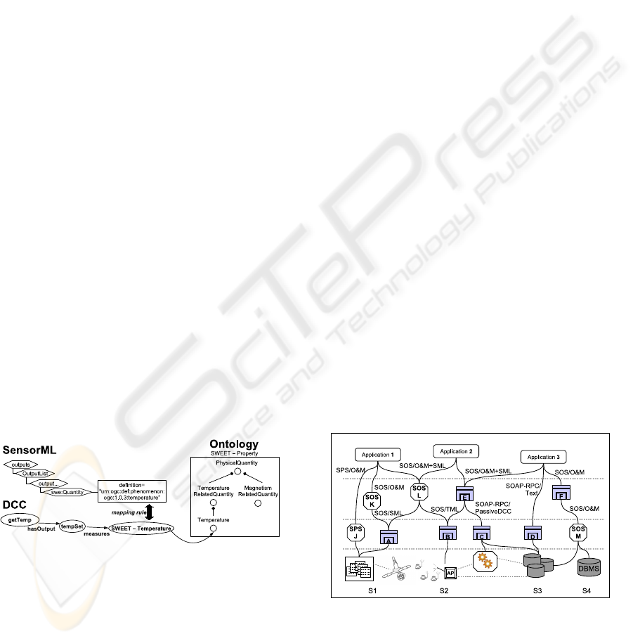
Figure 2: Mapping SML to DCC Metadata.
Consider, in our dengue example, a tempera-
ture sensor annotated with SML metadata, handled
by the DCC presented in Figure 1. SML meta-
data can be mapped to DCC metadata by estab-
lishing a correspondence between key SML ele-
ments and ontology concepts in OWL. An exam-
ple is illustrated in Figure 2, which maps a SML
sensor output to a DCC output. On the upper
left of the figure, the SML XML annotation de-
fines that the sensor outputs temperature readings
urn:ogc:def:phenomenon:ogc:1.0.3:temperature. On
the lower left of the figure, this output is mapped to
a DCC operation output: OGC XML temperature is
mapped to the “temperature” concept, part of SWEET
ontology (right of the figure).
Published sensor data can be combined with other
kinds of data. Consider, now, combining sensor data
on rainfall and temperature with data on mosquitoes
and diseases. Through DCCs we create bridges be-
tween OGC temperature concepts and other ontolo-
gies for mosquitoes and diseases. Our Tempera-
tureDCC (Figure 2) can be composed with other
DCCs – e.g., its OWL metadata can be further con-
nected with OWL ontologies for insects (mosquito)
and diseases (Dengue).
Sensor data may need to be published at distinct
granularities. A user may need a high level summary
of mosquito locations, and also a detailed view on
the rainfall data. This issue is considered by efforts
in SWE. Using SWE alone, however, is not enough.
SWE considers only process representation and not
access to process execution and customization. With
our extension, these processes become available for
invocation through DCC interfaces.
DCC interfaces are described in WSDL and
OWL-S and thus are compatible with Web service in-
terfaces. This way, we achieve adherence to OGC’s
standards for data representation and data access.
Moreover, since DCCs were originally conceived as
reuse units, they support flexibility in adding new pre-
processing functions. Finally, DCCs can offer access
not only via SOAP messages (in a Web environment),
but also be used in a standard programming environ-
ment.
Figure 3: A multi-level integration example scenario com-
bining DCC and SWE.
Figure 3 shows an example scenario combin-
ing data access using (i) specific implementations
of OGC’s publication standards (octahedrons) – e.g.,
SOS/SML, SPS/O&M; and (ii) DCCs (squares),
WEBIST 2008 - International Conference on Web Information Systems and Technologies
140
using DCC communication mechanisms – e.g.,
RPC/PassiveDCC – and OGC publication standards
– e.g., SOS/O&M, for Web service implementa-
tions. The labels in the lines show which commu-
nication mechanism and which sensor data encapsu-
lation strategy are employed. Each level passes data
through a processing function – from raw production
to complex manipulations. For instance, specific pre-
processing can be invoked to filter out outliers, sum-
marize data or merge data from several sources. Ba-
sically, one can design distinct DCCs dedicated to
each such pre-processing step, and application de-
signers can dynamically choose which implementa-
tion to adopt.
Applications and other processing services may
access data available in any level. Consider Appli-
cation 3, for instance. Let
S1
through
S4
be data
sources, where
S1
are satellite images from which
vegetation can be derived,
S2
is a network of tem-
perature sensors,
S3
is a database of current infection
case data, and
S4
is historical infection data. The ap-
plication corresponds to a scenario of map generation
using: sensor location details (from B and E), sensor
fused temperature data (from C and E), infection case
data (from D), and time-series data on monthly distri-
bution of past cases (from M and F). Maps generated
by Application 3 can be a final result – the spatial dis-
tribution simulating new case occurrences for the next
month. They also can be used to feed another appli-
cation.
4 IMPLEMENTATION
A few components were implemented to illustrate the
main ideas. Two sensor platforms, TelosB
2
and MI-
CAz, and a database system, PostgreSQL, were used
as data sources. One sensor data processing unit
was implemented, using a simple summarization al-
gorithm. The GeoServer http://www.geoserver.org/)
implementation of the Feature-Map-Coverage (FMC)
services, i.e., a WFS/WMS/WCS server, was
used to publish data as a service. The Map-
Builder http://communitymapbuilder.osgeo.org/ tool
was combined with the DOJO Javascript toolkit
http://dojotoolkit.org/ to enable Web browser visual-
ization.
The code running on the sensors was implemented
in NesC (Gay et al., 2003), a C-derived component
oriented programming language, using the TinyOS
(Levis et al., 2004) interfaces. Data access on the sen-
sors was carried out by ProcessDCCs with encapsu-
2
www.xbow.com/Products/productdetails.aspx?sid=252
lated drivers, implemented in Java.
A simple application was developed using these
components. Temperature data is collected by the
sensors and acquired by the respective ProcessDCCs.
Operations of these DCCs allow access to the data
in real-time. Other ProcessDCCs access these data
for making them available as raw real-time data, sum-
marized data, and time-series (stored on the database
system). The stored time-series are available to the
FMC server through the database and real-time data
are available directly.
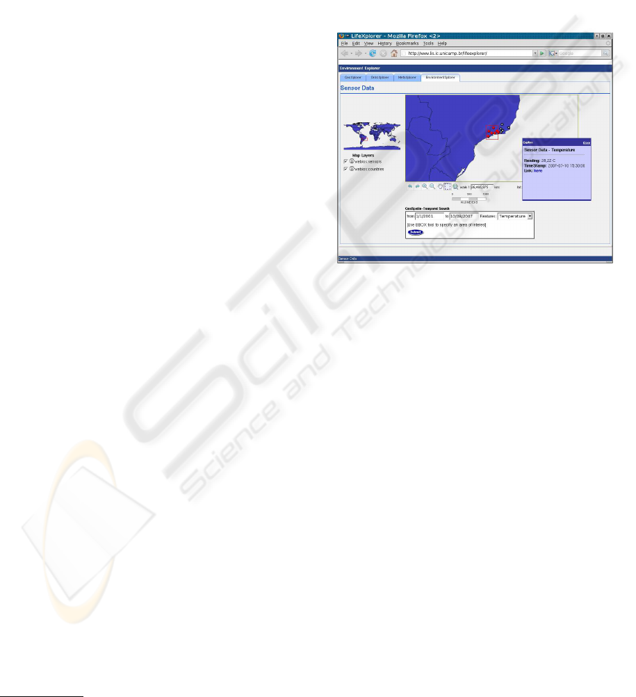
Figure 4: A screen capture of the application.
Figure 4 shows a screen capture of the client appli-
cation. Air temperature data is available in real-time
and as time-series, both with the option of using the
summarization feature.
5 RELATED EFFORTS
Efforts related to our work include scientific and sen-
sor data manipulation and publication.
General approaches are also possible. The ones
considered are: (i) Specialized implementations; (ii)
Software components and communication middle-
wares, such as CORBA, COM+ and .NET, EJB,
and others. The first approach has the classic over-
head of unnecessary repetition of work, hard main-
tenance, poor standardization and interoperability.
Components and middleware lack flexibility, seman-
tic descriptions, and, more importantly, homogeneous
treatment of data, sources and software.
(Iamnitchi et al., 2002) address collaboration in
a peer-to-peer scientific data sharing scenario. They
claim that emerging patterns typical of scientific col-
laboration can be exploited to improve data shar-
ing and search mechanisms. Although we are not
SENSOR DATA PUBLICATION ON THE WEB FOR SCIENTIFIC APPLICATIONS
141

concerned with network organization issues, DCC’s
caching mechanisms (Santanch
`
e et al., 2007) have a
similar effect, reducing latency time for frequently ac-
cessed resources.
(Aloisio et al., 2006) propose a grid architecture
to integrate sensor networks. The architecture regards
sensors as grid resources and employs SML to de-
scribe them. The proposal does not consider publi-
cation of sensor data outside their grid infrastructure,
hampering data reuse. (Chu et al., 2006) follow a
similar approach, employing grid technology. Their
architecture is strongly based on OGC standards for
sensor data, which is in line with our approach.
6 CONCLUDING REMARKS
This paper presented a solution for homogeneous ac-
cess on the Web to sensor generated data, for scien-
tific research. By extending OGC service standards
and implementing them as DCCs, our solution fosters
interoperability in situations where geospatial sensor
data need to be combined with other kinds of data
sources, a common scenario in scientific research.
Moreover, thanks to DCC construction principles, the
solution supports posting of schematics (e.g., a work-
flow) to pre-process data before publication.
Ongoing work includes developing new kinds of
DCC for implementing new mappings. We are also
extending the DCC design and combination frame-
work of (Santanch
`
e et al., 2007) to support automated
publication of DCCs as Web services.
ACKNOWLEDGEMENTS
This work is supported by FAPESP (grant 04/14052-
3), CNPq, CAPES, and an HP Digital Publishing
grant.
REFERENCES
Aloisio, G., Conte, D., Elefante, C., Marra, G. P., Mastran-
tonio, G., and Quarta, G. (2006). Globus Monitoring
and Discovery Service and SensorML for Grid Sensor
Networks. In Proc. 15th IEEE WETICE’06.
Chu, X., Kobialka, T., Durnota, B., and Buyya, R. (2006).
Open Sensor Web Architecture: Core Services. In
4th Int. Conf. on Intelligent Sensing and Information
Processing, pages 98–103.
Gay, D., Levis, P., Behren, R., Welsh, M., Brewer, E., and
Culler, D. (2003). The nesC language: A holistic
approach to networked embedded systems. In Proc.
ACM Conf. on Programming Language Design and
Implementation (PLDI’03).
Iamnitchi, Ripeanu, and Foster (2002). Locating Data
in (Small-World?) Peer-to-Peer Scientific Collabo-
rations. In Proc. International Workshop on Peer-to-
Peer Systems (IPTPS), LNCS.
Levis, P., Madden, S., Polastre, J., Szewczyk, R., White-
house, K., Woo, A., Gay, D., Hill, J., Welsh, M.,
Brewer, E., and Culler, D. (2004). Ambient Intel-
ligence, chapter TinyOS: An Operating System for
Wireless Sensor Networks. Springer.
OGC (2007a). OpenGIS Reference Model (ORM).
http://portal.opengeospatial.org/files/?artifact id=3836
(as of Oct 2007).
OGC (2007b). OpenGIS Sensor Web Enablement Architec-
ture. http:// www.opengeospatial.org/pt/14140 (as of
Oct 2007).
Pastorello Jr, G. Z., Medeiros, C. B., and Santanch
`
e, A.
(2007). Providing Homogeneous Access for Sensor
Data Management. Technical Report IC-07-012, In-
stitute of Computing, UNICAMP.
Raskin, R. and Pan, M. (2003). Semantic Web for Earth and
Environmental Terminology (SWEET). In Workshop
on Semantic Web Technologies for Searching and Re-
trieving Scientific Data.
Santanch
`
e, A., Medeiros, C. B., and Pastorello Jr, G. Z.
(2007). User-centered Multimedia Building Blocks.
Multimedia Systems J., 12(4):403–421.
WEBIST 2008 - International Conference on Web Information Systems and Technologies
142
