
How RFID Technology can Assist the Visually Impaired:
The Sesamonet System
Marcello Barboni, Francesco Rizzo, Graziano Azzalin and Marco Sironi
Joint Research Centre of the European Commission
Institute for the Protection and Security of the Citizen
Via E. Fermi 2749, 21020 Ispra (Va), Italy
Abstract. The Project’s objective is the development of an integrated system to
increase mobility of people with disabilities and their personal safety and secu-
rity, by identifying a secure path to walk through selected areas, particularly for
people with visual disability. This is done through the use of mature and proven
technologies (RFID, antennas, bluetooth, etc.) which only have to be integrated
for this specific application.The system is based on 3 main components: a path
made of transponders, a custom- designed walking cane and a smart phone. Each
RFID tag is associated to a message or a small beep. The system describes the en-
vironment and warns the user if there is a potential danger such as a road crossing
or a step.
1 Introduction
According to the World Health Organisation, in 2002 the number of people with sight
impairments worldwide was over 161 million, about 37 million of whom were blind.
Such impairments mostly affect the population older than 50 years of age. This issue is
of particular relevance for Europe because of its ageing population. The limited reality
perception of visually impaired people givesrise to an impressive limitation in their mo-
bility. Their movement capabilities in both outdoor and indoor unknown locations are
limited and dangerous and frequently become impossible without external assistance.
Therefore, the creation of an electronic navigation system for visually impaired people
represents an issue of relevant social importance. Recent improvementsin computer sci-
ence and new technologies have opened new perspectives with respect to the possibility
of helping people with sight disabilities. In particular, in the last years many different
navigation solutions have been investigated and proposed by the scientific community.
A large class of such systems envisage the use of the Global Positioning System
(GPS) to enable outdoor navigation [1], [2], [3], [4], [5], [6]. Although the use of satel-
lite position determination for usual navigation purposes is quite thorough, in this do-
main the error of one meter or more might be limiting in some situations (i.e. in prox-
imity of a crosswalk); moreover, the difficulty in receiving satellite signals indoors with
low-cost GPS receivers makes GPS based navigation systems not viable as a stand-
alone solutions for this domain, whereas they could be successfully used in conjunction
with other systems such as Sesamonet.
Barboni M., Rizzo F., Azzalin G. and Sironi M. (2008).
How RFID Technology can Assist the Visually Impaired: The Sesamonet System.
In Proceedings of the 2nd International Workshop on RFID Technology - Concepts, Applications, Challenges, pages 142-148
DOI: 10.5220/0001733301420148
Copyright
c
SciTePress

Other navigation systems for visually impaired people rely on the presence of var-
ious electromagnetic sources in the navigation environment, such as infrared emitting
diodes, which emit a beam carrying location information. A navigation unit collects and
elaborates such information. The main limitations are the need of constant direct line
of sight between emitters and receiving unit and the necessity of a power supply for the
external emitters.
Finally, recent studies address the integration of different technologies such as GPS,
dead-reckoning sensor positioning and active Radio Frequency Identification (RFID),
in order to obtain better navigation systems with a high accuracy in determining the
user’s position [7], [8]. Altough these systems offer a solution to the absence of indoors
GPS signal availability, they still have some essential lacks in the positioning require-
ments needed for an application for blind users. In particular, the error in the position
determination is about 1 meter or greater. Moreover, these systems are often complex
to use and have a cumbersome and uncomfortable sensors equipment.
Starting from these preliminary remarks, the Joint Research Centre, which repre-
sents the scientifical reference centre for the European Commission supporting the Eu-
ropean legislation, has proposed an innovative system for guiding visually impaired
people. In the continuation of this paper we discuss in detail the hardware infrastructure
of the prototype in section 2 and the software application and the navigation logic in
section 3. Finally, in section 4 we discuss results and possible future developments.
2 System Description
Starting from the state-of-art described in the introduction, we designed an innovative
and affordable navigation system for blind persons, based on the use of passive low
frequency RFID technology, called Sesamonet (Patent Pending). The project’s name is
the acronym of Secure and Safe Mobility Network.
Usually, visually impaired persons feel the environment by means of a greatly de-
veloped sensibility of auditory and tactile channels. In addition, they utilize useful tools,
such as the guide dog or the walking cane, to recognize surroundings and avoid obsta-
cles: our goal is to leverage as much as possible the blind person’s familiarity with
these tools by integrating the well-known walking cane with a navigation system based
on passive RFID technology. The main idea consists in recycling the RFID passive
transponders from animal tagging and installing them into the ground to create a secure
path: the blind person’s walking cane, fitted with an antenna and a reading system, de-
tects and reads the RFID micro-chips and sends a signal, through a bluetooth channel,
to a Smart Phone. The Smart Phone, equipped with a database containing information
on the location, elaborates this signal and communicates to the user, through a bluetooth
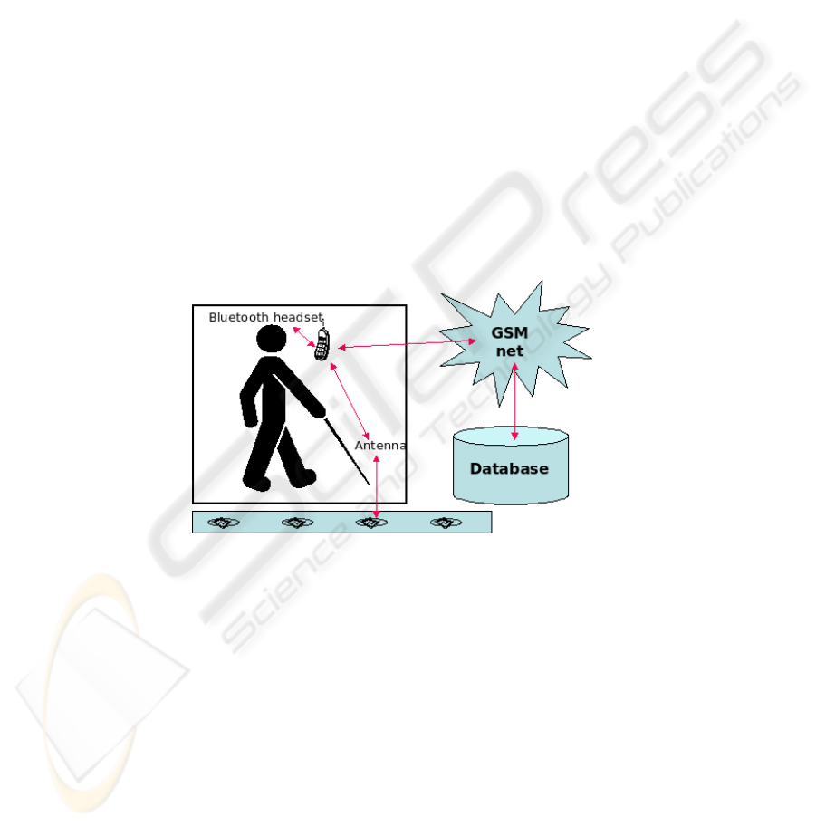
headset, information regarding the path. Figure 1 illustrates the logical operation of the
Sesamonet system.
The system is designed to be as similar as possible to existing mobility-aiding tools,
while enhancing their capabilities and usefulness, and bringing them up to date with
modern technological developments. This does not mean, however, that Sesamonet is a
drop-in replacement for existing tools: the users should foresee a training period before
being able to exploit its full potential. Training should be carried out by qualified train-
143
ing associations such as the Italian ”Association for orientation-mobility and personal
autonomy instructors”.
It is worthwhile noting that a large-scale deployment of the Sesamonet system
would create a need for consultants, instructors and other personnel; this would open
many opportunities of employment for the visually impaired, who would be the most
qualified to fill this particular market’s demand.
The possibility to send information through the bluetooth channel makes it possible
to activate any electro-mechanical device which can be linked to a serial port, such as a
traffic light. Similarly, if the system is deployed on a modern smartphone, there is also
the option of using WiFi to activate electro-mechanical devices.
The technology on which Sesamonet is based is low frequency (LF) RFID, at 134.2
KHz. The choice of LF transponders over other frequenciessuch as high frequency(HF)
or ultra-high frequency (UHF) was made primarily because of the former’s greater ro-
bustness to external interference factors, such as the proximity with liquids or metals.
The choice of passive technology was made because there usually is no fixed power
source available in outdoor environments, and battery power is too expensive and lim-
ited for this application. In passive RFID the antenna irradiates the transponders with
its electromagnetic energy, and the transponders use this energy to reply to the reader.
Thus the tag doesnt need a battery to function, and this makes its lifespan theoretically
infinite.
Fig.1. Sesamonet overview.
A navigation system similar to our Sesamonet project has been recently proposed in
Japan [9], [10]. Some important differences between these navigation systems could be
highlighted. The japanese Free Mobility Assistance project is based on the use of pas-
sive LF RFID tags working at the frequency of 125 KHz. In this system the RFID tags
are embedded into the concrete blocks guiding visually impaired people. Moreover, in
order to obtain an acceptable reading distance, the tag’s antenna have to be extended
over the entire guide block surface. Therefore, a large scale installation of such naviga-
tion paths should become difficult from the economic and architectural points of view.
In addition, the portable information terminal used to elaborate the tags information
is a specific device (Ubiquitous Communicator) while in our solution any commercial
144
Smart Phone, equipped with a minimun processor of 200MHz and a Bluetooth version
1.2 (or greater), should be used.
2.1 The Secure Path
Once the tag is irradiated by the reader, it responds by giving its UID (Unique IDen-
tifier). This is a 12-digit code unique to the single tag. The secure path is made of a
sequence of tags embedded into the pavement, usually at a distance of 60cm one from
the other. In some configurations there is a single line of tags running parallel to a
natural landmark (e.g. a building, a sidewalk, etc), in others there can be a double or
triple line to help keep the user centered inside the path. The final scheme of the secure
path is to be decided with representatives of the blind associations, and in general after
extensive testing of the system by visually impaired users.
The passive RFID transponders are embedded directly into the ground; as a conse-
quence, these components must have a high resistance to physical stress (i.e. vibrations,
humidity, temperature range etc.).
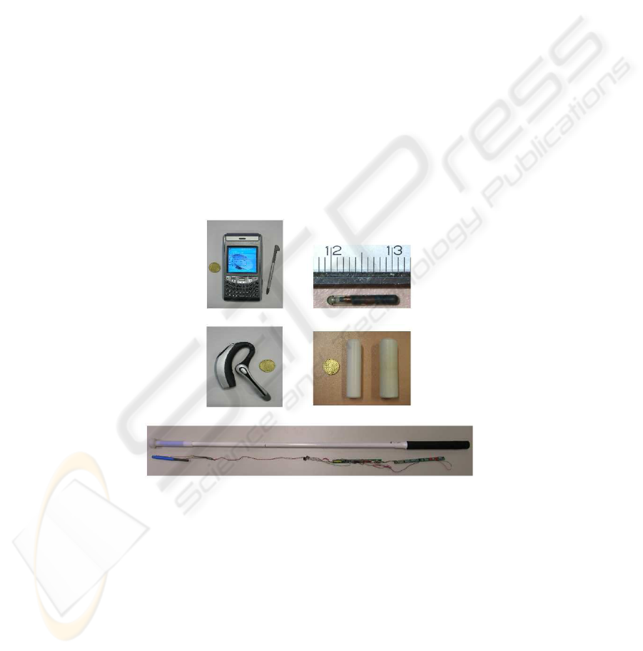
Fig. 2 shows the elements which constitue the system: a generic PDA with a blue-
tooth earphone, LF RFID transponders and the visually impaired stick with the suitable
electronic.
Fig.2. The Sesamonet components: PDA/Smartphone with a earphone, RFID transponders recy-
cled from animal tagging and the RFID-enabled walking cane.
We adopt passive RFID transponders recycled from animal tagging. Livestock iden-
tification through RFID chip tagging, in compliance with ISO standard 11784/85, will
become compulsory in a near future for European Member States with an animal pop-
ulation exceeding 600000 units. The already large number of passive RFID tags avail-
able after the use in the livestock market will therefore see an increase. In Europe each
145

year about 50 million tags used for the tagging of live animals are destroyed because,
for hygenical reasons, they cannot be reused on animals. Therefore, their re-use in the
Sesamonet project saves the cost of their disposal and, at the same time, reduces Sesa-
monet’s cost. Moreover, passive transponders do not require an external power source
because they are powered by the incoming radio frequency signal, thus decreasing the
overall system’s maintenance costs. Being designed for animal tagging, these transpon-
ders have a very high environmental resistance.
The outdoor test paths we deployed so far did not suffer any loss of functionality
due to environmental factors. The oldest on, at JRC premises, is over two years old.
A possible critical situation for the system can occur when in the path are present
obstacles not already recorded in the database. In order to avoid such situation, it is
possible to mark the secure path borders with colourful signs which signal to sighted
persons the presence of the path.
2.2 The RFID-Enabled Walking Cane
The RFID-enabled walking cane has been designed to closely resemble a normal walk-
ing cane, the main difference being that this cane has an antenna with a ferrite core
located in correspondence of its tip as showed in Fig. 2, an electronic circuit that gov-
erns the transmission to and from the tag, a bluetooth module and a battery pack in the
handle. We decided for a bluetooth module Class 2, which has an operating range of 10
meters and a power consumption of 2.5 mW, as a comprise between power saving and
connection reliability. The result is a cane that weights a bit more than a normal cane,
but is well-balanced and usable. The walking cane is designed to detect and read a tag
within a 20 cm radius; a greater reading distance would be technically possible but it
would be counterproductive, as it would lower the precision of the system and raise the
uncertainty on which tag is actually being read.
2.3 The Smartphone
The brain of the system is the smartphone, where data are stored and elaborated. A
smartphone substantially is any PDA (Personal Digital Assistant) or any last (or second-
last) generation cellular phone. For example, any cell phone that supports the installa-
tion of applications such as a GPS navigator is capable of running Sesamonet. The
smartphone is associated by means of to a bluetooth communication to the walking
cane and to an earphone. An important hardware requirement for the smartphone is
that its bluetooth radio is a 1.2 (or greater) version device, in order to manage two or
more connections at the same time. Sesamonet has been developed and tested on PDAs
running Windows Mobile and Symbian operating systems.
The smartphone runs a software that seeks in its internal database the UID received
from the walking cane and retrieves the association between the UID and the voice
message that describes it. It then sends the message to the earphone.
146

3 The Navigation System
The electronic path formed by the RFID tags embedded into the pavement can be
walked in both directions, and entered at any point. The path can fork into different
paths, can merge and can cross another path. These are common situations that have to
be managed by the navigation software. The software must have a way of knowing, at
all times, the position of the user within the path and the direction he/she is moving in.
To do this the path must be divided into logical segments and the tags must be
numbered sequentially within each segment. Each segment can have an arbitrary length.
We associate two numbers to each tag, one indicating the segment number and one
indicating the single tag position within the segment. This way a single ”seek” operation
will yield univocally all data associated to a tag.
The system stores in an internal buffer the last 5 tags read; it can thus recognize a
change in direction and adapt the choice of messages to relay to the user. For example a
”turn right” instruction becomes ”turn left” when navigating in the opposite direction.
If a user enters a path at a random point the system waits for the reading of the second
tag to decide the direction he is walking in. This second tag doesn’t necessarily need to
be consecutive.
3.1 Field Tests
After a first test electronic path deployed at JRC premises, a full scale demonstration
of the system’s capabilities has been done on the 19th of October 2007 in the city of
Laveno (Varese, Italy). Sesamonet’s launch in Laveno gave the opportunity to show all
the features of the system by testing it with a visually impaired user. In particular, the
system’s possibility to guide the user along the electronic path automatically inverting
the navigation logic when the user changes direction, the possibility to enter the path
at any generic position and the capability of activating a traffic light by simply reading
a designated transponder have been given. A second installation has been carried out
in December 2007 in the Prealpi Giulie Park (Udine, Italy). In both cases the system
is now installed and working. Visually impaired users who tried the system expressed
very positive feedbacks regarding its guidance features and its usability.
4 Summary and Future Developments
From a technical standpoint, the basic functionalities are in place and can serve as a
solid foundation for the addition of new features, including:
– addition of navigating functionalities so that the system can guide a person to des-
tination instead of only giving warnings and describing the environment,
– future generation smartphones will have an integrated GPS receiver: the system
will use the GPS data when available,
– addition of specific modules for different environments: for example in railway sta-
tions there could be a blind-friendly booking facility, express check-in in airports,
etc.
147

Finally, the system can rely on a robust and widespread infrastructure such as the
GSM/GPRS network, it can update its database in real time and offer a great number of
additional services.
Our prototypes and test paths been tested in different environments in collaboration
with the Italian Blind Association and constitute a solid proof of principle. Being that
the JRC is a research institute, the next step (industrialization) has to be carried out by
parties interested in the exploitation of this technology. The system is patent pending.
References
1. A. Helal, S. E. Moore and B. Ramachandran: Drishti: An Integrated Navigation System for
Visually Impaired and Disabled . Proceedings of the Fifth International Symposium on Wear-
able Computers, (2001) 149–156
2. Z. Hunaiti, V, Garaj, W. Balachandran, F. Cecelja: An Assessment of 3G link in a Navigation
Systems for Visually Impaired Pedestrians. Proceedings of the Fifth International Symposium
on Wearable Computers, (2005).
3. http://www.esa.int/esaNA/ESAKN58708Dindex0.html
4. Thomas STROTHOTTE, Helen PETRIE, Valerie JOHNSON, and Lars REICHERT: MoBIC:
an aid to increase the independent mobility of blind and elderly travellers. 2nd TIDE Congress,
Paris, La Villette, 26 - 28 April 1995. IOS press, Amsterdam, 348–351
5. L. Ran, S. Helal and S. Moore Drishti: An Integrated Indoor/Outdoor Blind Navigation System
and Service. Second IEEE International Conference on Pervasive Computing and Communi-
cations (PerCom’04), p. 23
6. Balachandran, W.; Cecelja, F.; Ptasinski, P. A GPS based navigation aid for the blind. Applied
Electromagnetics and Communications, 2003. ICECom 2003. 17th International Conference
on Volume , Issue , 1-3 Oct. 2003 Page(s): 34 - 36
7. S. Beauregard and H. Haas Pedestrian Dead Reckoning: A Basis for Personal Positioning. Pro-
ceedings of the 3rd Workshop on Positioning, Navigation and Communication (WPNC2006)
8. M. Kourogi, N. Sakata, T. Okuma, and T. Kurata Indoor/Outdoor Pedestrian Navigation with
an Embedded GPS/RFID/Self-contained Sensor System. Proceedings of the 16th International
Conference on Artificial Reality and Telexistence (ICAT2006), pp.1310-1321 (2006)
9. K. Sakamura, Y. Toya, K. Oka Conduct of free mobility assistance project. Proceedings of the
12th World Congress on Intelligent Transport Systems (ITS 2005)
10. J. Yamada, T. Adachi, S. Setoshita Technical features of the free mobility assistance system.
Proceedings of the 12th World Congress on Intelligent Transport Systems (ITS 2005)
148
