
A GIS DATA UPDATING METHOD WITH VIDEO
Ruijun Liu, Myriam Servi
`
eres and Guillaume Moreau
LUNAM, Ecole Centrale de Nantes, CERMA-IRSTV, 1 Rue de la No
¨
e, 44321 Nantes, France
Keywords:
Geographic Information System (GIS), Architecture Facade Reconstruction, User Knowledge, Video.
Abstract:
We present a method for extracting and updating Geographic Information System (GIS) data from video.
This paper uses a ground-view video sequence as input data. In the first step, feature points are extracted from
video, which provide the structure information for architecture facade reconstruction; after discarding outliers,
we create the footprint and reconstruct a 3D model. The second step is the back-projection process. In the
third step, we correct the footprint and update it by using user knowledge. Finally, this information is used to
update GIS.
1 INTRODUCTION
Model reconstruction is quite important in Computer
Graphics (CG) research field, especially, the recon-
struction of urban 3D model. It can be applied in
Geographic Information System (GIS) field. We will
focus on this interdisciplinary research.
A GIS allows geospatial information manipula-
tion as abstraction, acquisition, storage, analysis and
visualization (Den
`
egre and Salg
´
e, 2004). It describes
an urban information digitally, as vector data or as
raster data. GIS data quality is an important aspect.
However, with the city’s development, GIS data can
be inconsistent with reality due to building construc-
tion or destruction. Therefore, users have to maintain
data consistency and this need arises from frequent
GIS updating. As stated in (Heipke et al., 2008), up-
dating GIS data should consider two aspects: first one
is logical consistency, second one is a comparison be-
tween data and reality.
Many researchs use aerial image to reconstruct 3D
buildings, but there are few studies about the reverse
process, using 3D reconstruction method to update
GIS data (Zebedin et al., 2008). The key motivation
of our research is to focus on a GIS data updating
method only using a ground-based video sequence as
input. This video sequence is easier to be acquired
than aerial images and only requires a handy camera,
which is not a complex equipment. Traditional meth-
ods often use LiDAR to measure building and recon-
struct GIS data (Li et al., 2011).
Our first goal is to update GIS data, such as foot-
print. The first step of our solution is to capture a gr-
ound-view video, from which, we will extract build-
ing information and remove the noise. The second
step is to use this extracted information to build a 3D
model. The first building model is a 3D geolocal-
ized box. Its extent and width are basic, but accurate
enough to update GIS data.
After a brief review of related work in section 2,
we detail our algorithm in section 3 starting with an
overview of the whole pipeline in section 3.1. In sec-
tions 3.2 to 3.4, we present the information extraction
based on data acquisition, the architecture facades re-
construction and the updating process. Preliminary
results are provided in section 4. Conclusions and fu-
ture work are presented in section 5.
2 RELATED WORK
The scientific issues in relation with our method
mainly include two different types of techniques: ar-
chitecture facade reconstruction and GIS data acqui-
sition and updating.
2.1 Architecture Facade Reconstruction
Existing architecture reconstruction methods can be
divided into three categories:
• rule-based architecture reconstruction methods
(M
¨
uller et al., 2006) and (Kelly and Wonka,
2011),
• image-based interactive architecture reconstruc-
tion methods (Pollefeys et al., 2008),
511
Liu R., Servières M. and Moreau G..
A GIS DATA UPDATING METHOD WITH VIDEO.
DOI: 10.5220/0003856905110514
In Proceedings of the International Conference on Computer Graphics Theory and Applications (GRAPP-2012), pages 511-514
ISBN: 978-989-8565-02-0
Copyright
c
2012 SCITEPRESS (Science and Technology Publications, Lda.)
• vision-based automatic architecture reconstruc-
tion methods (Goesele et al., 2007).
2.2 GIS Data Acquisition and Updating
Until now, images and remote sensing are the main
technologies for GIS data acquisition and update.
(Steinocher and Kressler, 2006) and (Heipke et al.,
2008) provide us two good overviews of existing ap-
proaches. (Heipke et al., 2008) is a summary of the
GIS data updating process from images, focused on
the macroscopical updating process, rather than on
the individual algorithm. Users need to participate in
the updating process such as: creation, deletion, split-
ting and merging of objects, and the modification of
GIS data.
3 PROPOSED PROCESS
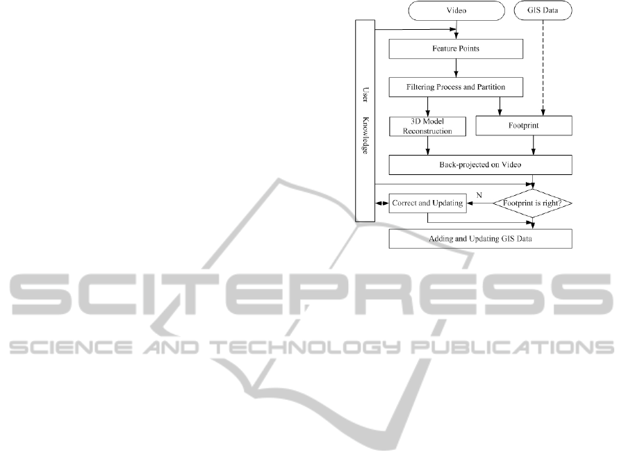
3.1 Overview
GIS users may encounter circumstances where GIS
data are inconsistent with real data and need to be
updated. In our method we design two scenarios to
complete this task depending on the input data. One
is using only video as an input and the other one is
using video and existing GIS data as inputs. The dif-
ference is the footprint acquisition, but the updating
method is the same. Figure 1 presents the pipeline
of our designed scenarios. First, we reconstruct a 3D
model with the help of the user knowledge by using
the feature points extracted from video, and then we
create the footprint or acquire it from GIS data. Sec-
ondly, 2D footprint and 3D model are back-projected
onto the video. Then, if the footprint is inaccurate,
we interactively correct it by user knowledge. Finally,
updating GIS data is achieved.
At present, the whole process is not real-time. We
have finished almost all steps of our scenario recon-
structing a 3D model, only the correction part is in
progress. We will provide some details on our future
work in section 5.
3.2 Information Extraction from Video
3.2.1 Feature Points Extraction
In outdoor environments, many elements may oc-
clude the buildings, such as trees or cars, which make
the feature points tracking fail. Therefore, in or-
der to achieve the main algorithm, as a first test, we
used a simple mockup. The whole acquisition pro-
cess simulates the outdoor environment. Then we
Figure 1: Pipeline of GIS data update.
use a state-of-the-art real-time Structure from Motion
(SfM) algorithm, Parallel Tracking and Mapping sys-
tem (PTAM) (Klein and Murray, 2007), to obtain a
feature points cloud and camera parameters. PTAM
updates the map correspondences using bundle ad-
justment, and extracts several thousands of feature
points. At the end, we also compute the normal of
each point as a preparation of the reconstruction pro-
cess in this step.
3.2.2 Filtering Process and Partition
Due to, for example, bad video quality or track-
ing algorithm instability, there are some outliers in
the feature points cloud that will cause bad result in
the next step. Therefore, we filter the noisy points
with RANSAC algorithm (Fischler and Bolles, 1981).
RANSAC is a general parameter estimation algorithm
designed to cope with outliers in the original data. Af-
ter the filtering process, in order to reconstruct each
facade individually, our approach needs to split the
feature points cloud into several parts.
3.3 Reconstruction
Based on the extracted information, our reconstruc-
tion algorithm aims at reconstructing several facades
fast and effectively.
3.3.1 Footprint Generation from Feature Points
3D world coordinate system is defined as follows: the
red line is X-axis, the green line is Y-axis and the
white line is Z-axis. All facades are parallel with the
Z-axis, therefore we project the 3D feature points onto
the X-Y plane, then a part of footprint is obtained us-
ing RANSAC algorithm. We consider the footprint to
GRAPP 2012 - International Conference on Computer Graphics Theory and Applications
512

be regular. Finally, we can generate the whole foot-
print. In real environment, we have another informa-
tion acquisition, the existing GIS data, which can sup-
ply useful information for footprint generation.
3.3.2 Facades Modeling
Since we have discarded the noisy feature points, and
both the feature points and footprint have been di-
vided after the partition procedure in Section 3.2.2,
the last reconstruction step is to finish facades model-
ing. We use (Liu et al., 2011) method to achieve this
step.
We assume that the bottoms of all facades are
in the same plane and all facades are vertical to the
ground plane. With these hypotheses we need to re-
cover 3 parameters for each facade: left boundary and
right boundary location and height.
Based on section 3.2.2, the vector data of footprint
are divided into different facades. The facade enables
us to estimate the left boundary and right boundary
location, the facade height is the unique parameter
calculated. We consider there is a series of buffer re-
gions (BF) surrounding the footprint limits (Figure 2
(a)), therefore, we use the value of the highest point in
each buffer as the height of corresponding facade, as
shown in Figure 2 (b). After obtaining the max value,
several geometric planes can be modeled as facades.
Figure 2: Reconstruction process: (a) buffer regions sur-
rounding footprint (b) max height point extraction.
3.4 Updating Process
In this section, we describe the back-projection of the
footprint and 3D model onto video. User knowledge
enables us to achieve this stage easily and we update
the GIS data interactively.
3.4.1 Matching Footprint and 3D Model on
Video
For matching, we should calculate the extrinsic cam-
era parameters.
Then the correspondence between the camera co-
ordinate system and the world camera coordinate sys-
tem is established. We have calibrated the camera
before the extraction process, and have obtained the
intrinsic camera parameters.
3.4.2 Footprint Updating
We can know if the footprint exists in GIS from user
knowledge. If it does not exist, it is added into the
GIS. If it exists an old one, we need to compare both
of them. After 2D footprint and 3D model back-
projected on the video, we can confirm which foot-
print is correct using the user knowledge and update it
to replace the old one. This interactive process makes
the footprint more accurate.
4 RESULTS
We have implemented our system and tested it on
street-view videos captured in town.The following re-
sults have been implemented in C++ code and on a
PC with Intel Core i7-870 CPU processor, NVIDIA
Quadro FX 580 graphics card. We tested our algo-
rithm on a video of ”building” model, and it ran well
from the extraction to the reconstruction (Figure 3).
Figure 4 shows another experiment. The video is
acquired by webcam Logitech QuickCam Pro 9000,
fixed on a vehicle. The three bottom figures and the
top-right figure show us the whole pipeline of our al-
gorithm. The video consists of 212 frames lasting
about 9 seconds. At the beginning of the extraction
process, we pause the video every 0.5 second. Then
we use the RANSAC algorithm. Each iteration selects
randomly 3 feature points, and distance threshold is
0.05 measured in world coordinate system. Usually,
we have 3000 to 4000 feature points, and choose the
probability, that at least one of the random samples of
points doesn’t include any outlier, as 0.99.
In this experiment, due to the occlusions in out-
door video, footprint generation is in progress. As
for GIS data, we use ESRI Shapefile and the building
layer of Nantes. Then we load and update it through
the OGR library, which is an open source code to deal
with GIS vector data, as shown in three top figures in
Figure 4.
5 CONCLUSIONS
We have proposed a GIS updating approach using
a video captured along the street, producing the ge-
ometric facades model and updating GIS data fi-
nally. This approach enables us to update footprint
and add information to GIS. This method depends
on some user knowledge to make some interactive
operations. But the whole process reconstruct a 3D
model perfectly only with our box building, however
with outdoor real building, the facades reconstruction
A GIS DATA UPDATING METHOD WITH VIDEO
513
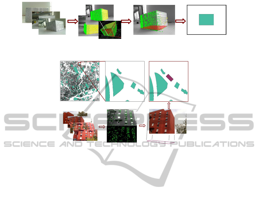
Figure 3: One updating GIS data process with a ”building” model.
Figure 4: Another updating GIS data process: the footprint of new building doesn’t exist in old GIS data.
and footprint generation are not yet available. These
works are in progress. There are several limitations,
such as it is not yet a real-time process and the updat-
ing process in outdoor environment faces the prob-
lem of occlusions. For our future work, we will fol-
low three directions. Firstly, we will make it work in
outdoor environment. Secondly, we will improve the
updating process, for example, the correction part. Fi-
nally, we will update 3D GIS by computing the height
of building and insert this information into GIS data.
REFERENCES
Den
`
egre, J. and Salg
´
e, F. (2004). Les syst
`
emes
d’information g
´
eographiques. Presses Universitaires
de France, 2nd edition.
Fischler, M. A. and Bolles, R. C. (1981). Random sample
consensus: a paradigm for model fitting with appli-
cations to image analysis and automated cartography.
Commun. ACM, 24:381–395.
Goesele, M., Snavely, N., Curless, B., Hoppe, H., and Seitz,
S. (2007). Multi-View Stereo for Community Photo
Collections. In IEEE 11th International Conference
on Computer Vision(ICCV) 2007, pages 1–8.
Heipke, C., Woodsford, P. A., and Gerke, M. (2008). Updat-
ing geospatial databases from images. In Advances in
photogrammetry remote sensing and spatial informa-
tion sciences 2008 ISPRS congress book, pages 355 –
362. CRC.
Kelly, T. and Wonka, P. (2011). Interactive architectural
modeling with procedural extrusions. ACM Trans.
Graph., 30:14:1–14:15.
Klein, G. and Murray, D. (2007). Parallel tracking and
mapping for small AR workspaces. In Proc. Sixth
IEEE and ACM International Symposium on Mixed
and Augmented Reality (ISMAR’07), Nara, Japan.
Li, Y., Zheng, Q., Sharf, A., Cohen-Or, D., Chen, B., and
Mitra, N. J. (2011). 2d-3d fusion for layer decomposi-
tion of urban facades. In IEEE International Confer-
ence on Computer Vision (ICCV), Barcelona, Spain.
Liu, R., Servi
`
eres, M., and Moreau, G. (2011). Facade mod-
eling from a ground view video with map constraints.
In IAPR Machine Vision Applications, Japan, Nara.
M
¨
uller, P., Wonka, P., Haegler, S., Ulmer, A., and Gool,
L. (2006). Procedural modeling of buildings. ACM
Transactions on Graphics, 25(3):614–623.
Pollefeys, M., Nist
´
er, D., Frahm, J. M., Akbarzadeh, A.,
Mordohai, P., Clipp, B., Engels, C., Gallup, D., Kim,
S. J., Merrell, P., Salmi, C., Sinha, S., Sinha, S., Tal-
ton, B., Wang, L., Yang, Q., Stew
´
enius, H., Yang, R.,
Welch, G., and Towles, H. (2008). Detailed real-time
urban 3D reconstruction from video. International
Journal of Computer Vision (IJCV), 78(2-3):143–167.
Steinocher, K. and Kressler, F. (2006). Eurosdr change de-
tection report. EuroSDR Official Publication Series,
50:111–182.
Zebedin, L., Bauer, J., Karner, K., and Bischof, H. (2008).
Fusion of feature-and area-based information for ur-
ban buildings modeling from aerial imagery. Euro-
pean Conference on Computer Vision(ECCV), pages
873–886.
GRAPP 2012 - International Conference on Computer Graphics Theory and Applications
514
