
O-Mopsi: Mobile Orienteering Game using Geotagged Photos
Andrei Tabarcea, Zhentian Wan, Karol Waga and Pasi Fränti
Speech and Image Processing Unit, School of Computing, University of Eastern Finland, Joensuu, Finland
Keywords: Location-aware Gaming, Mobile Gaming, GPS, Orienteering.
Abstract: Location-based mobile gaming combines gameplay with physical activity. We have developed a game, O-
Mopsi, based on the concept of orienteering, which can be played on mobile phones with GPS receiver and
Internet connection. In order to complete a game, a player must visit a set of targets that are photos chosen
from a user-generated geotagged database. Game creation, management and live tracking can be done using
a web interface. The game was presented at an annual international festival which is aimed at introducing
science and technology to school children and the overall feedback received from the players was positive.
1 INTRODUCTION
Whilst using mobile devices for playing games is
very popular and long-established idea, mobile
gaming which uses the player’s location and
involves physical activity is a recent idea, although it
starts to gain popularity. With the fast development
computing devices, mobile location-based gaming
has evolved from using wearable computers and
head-mounted displays (Piekarski and Thomas,
2002) to using mobile phones with access to Internet
and GPS localization.
We introduce a mobile location-aware game, O-
Mopsi, which is based on the classical concept of
orienteering and exploits the multimedia data
available in a geotagged user generated photo
collection (cs.uef.fi/mopsi/photos). A game is
created by defining a set of targets and a player can
complete the game by visiting all the targets in any
order. A target is represented by a photo along with
location information.
O-Mopsi can be played using a mobile
application for Symbian phones, which is available
at cs.uef.fi/o-mopsi/ along with the web interface.
The mobile client has functionalities such as
plotting targets on the map, displaying compass data
and giving audio clue with varying pitch and sound
frequency about the distance to a target. Photos are
used as an additional aid for identifying a target
The web interface allows game management,
real-time player tracking, post-game trail analysis
and suggesting tours calculated by either greedy
heuristics or an ant colony-based optimization.
2 RELATED WORK
One of the first examples of location-aware games is
Pirates! (Björk et al., 2001), which demonstrates
how proximity-triggered technology can be
integrated into computer game design.
A large number of location-aware games are
adaptations of traditional board games or computer
games. including Quake (Piekarski and Thomas,
2002), Pacman (Cheok et al., 2004), Tic-Tac-Toe
(Schlieder et al., 2006), Monopoly (Li et al., 2008)
or Chase and Catch (Misund et al., 2009).
Mobile gaming is often combined with
education. For example, Savannah (Facer et al.,
2004) aimed at children, who use devices with GPS
to navigate and study animal behavior in a virtual
savannah. Education is also the goal of Skattjakt
(Treasure Hunt), (Spikol and Milrad, 2008), which
encourages players to get physically active by
solving a mystery surrounding a castle. It considers
that mobile outdoor games are well suited for novel
learning activities that involve physical motion,
problem solving, inquiry and collaboration.
A common approach is combining game reality
with physical reality. For example, Song of the
North (Lankoski et al., 2004) is game inspired by
Nordic mythology, which combines a virtual spirit
world with the physical world and in which the
players interact by using mobile devices. Another
example of mixed reality is Can you see me now?
(Benford et al., 2006), where players are chased
through a virtual model of a city by runners
(professional performers equipped with Wi-Fi and
300
Tabarcea A., Wan Z., Waga K. and Fränti P..
O-Mopsi: Mobile Orienteering Game using Geotagged Photos.
DOI: 10.5220/0004370203000303
In Proceedings of the 9th International Conference on Web Information Systems and Technologies (WEBIST-2013), pages 300-303
ISBN: 978-989-8565-54-9
Copyright
c
2013 SCITEPRESS (Science and Technology Publications, Lda.)
GPS). The rules are similar with the game of catch,
but the “runners” have to traverse actual city streets
in order to capture the online (virtual) players.
In a location-aware game, photos can be used in
various ways, such as a means of interaction
(Suomela and Koivisto, 2006) or to provide
additional information about game targets, such as in
See It (Neustaedter and Judge, 2012).
O-Mopsi is based on the concept of virtual
orienteering, similarly to applications such as
OrientGames (www.orientgames.com) or Virtual
Orienteering Game (www.vorienteering.com). The
difference between O-Mopsi and most of the other
orienteering-based games are that the targets are
shown as photos and the order of visiting the targets
is freely chosen.
3 GAME RULES
The goal of the game is to visit all targets in the
shortest time. A target is identified by its location,
photo and a short description. A game is created by
selecting photos from the Mopsi photo collection.
A game starts when the player visits the first
target. The order of targets is not fixed and it can be
freely chosen by the player. A game ends when the
player visits all the targets. To visit a target, a player
has to be closer than 20 meters from its location.
This threshold was chosen taking into consideration
GPS inaccuracies. Players are ranked in the order of
completion time. The total distance, the starting
target or the order of visiting targets do not affect
ranking.
The game shares similarity with the concepts of
orienteering and geocaching (Cameron and Ulmer,
2004), which both require identifying and visiting a
number of targets.
Orienteering requires navigating from point to
point in a predefined order using a map and a
compass. Unlike orienteering, in O-Mopsi the
targets can be visited in any order, encouraging
players to develop different strategies and to choose
the starting point. Orienteering is focused on
identifying the location on map whereas O-Mopsi
provides additional hint in the form of photo of the
target.
Geocaching requires finding a hidden treasure (a
collection of things placed in a container called
geocache and placed in a location available to the
public). The GPS location of the cache is published
online and other people need to find the cache and
replace an item from the collection by another. O-
Mopsi also requires find a certain GPS location
defined by another player, but the location is
identified by a photo. Additionally, in Geocaching,
the time does not matter and targets are not grouped
into games or other entities.
O-Mopsi uses virtual targets, whereas
orienteering and geocaching use physical objects.
4 O-Mopsi WEB
O-Mopsi web interface can be used for creating and
managing a game, displaying the proposed shortest
path of a game, displaying game results and viewing
real-time player progress.
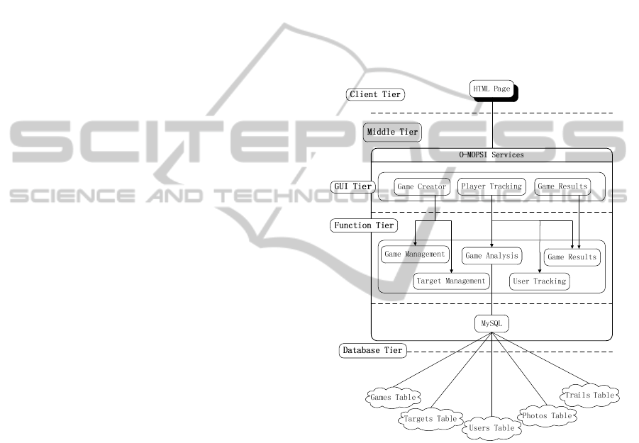
Figure 1: Architecture of the O-Mopsi website.
Fig. 1 shows the architecture of the website,
along with the main functions. We use Google Maps
for displaying targets, the interface is developed
using PHP and JavaScript and the game data is
stored in a MySQL spatial database.
The client tier contains the HTML page which is
presented to the user. The middle tier is composed of
the GUI tier and the function tier. The GUI tier
includes interfaces for the creation of the game, for
the live tracking of the players and for the game
results. The function tier includes all the server logic
operations: game and target management, game
analysis, user tracking and game results. Finally, the
database tier consists of the tables needed to store
game data (games, targets, users, photos and trails).
O-Mopsi:MobileOrienteeringGameusingGeotaggedPhotos
301
4.1 Game Management
A game is created by providing a description for a
set of targets. The targets are selected from the
Mopsi photo collection with the help of keyword
search or using the location-based recommendation
documented in (Waga et al., 2012b).
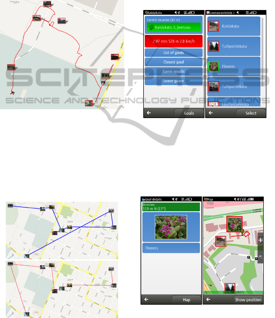
Figure 2: Live player tracking.
4.2 Game Tracking and Analysis
Player’s location and the targets can be seen in real
time on web in the Game Hall (see Fig. 2). This
allows viewing the player’s progress and analyzing
the players’ trails along with other characteristics
such as speed or moving type using the algorithm in
(Waga et al., 2012a). The user has also the option of
viewing the shortest route calculated by ant colony
optimization algorithm (see Fig. 3).
Figure 3: Ant colony optimized route.
5 GAME CLIENT
The game client is available for Symbian phones. It
is developed using C++ and the Qt libraries. A
Windows Phone version is in development and iOS
and Android versions are considered in future. After
logging in, the player can choose to join a new game
or continue an existing active game.
Figure 4: The main screen of the application (left) and a
list of targets (right).
During gameplay, the player’s location is tracked
and stored on server. The main screen of the
application (see Fig. 4) shows the current location,
accuracy and statistics such as playing time, distance
and speed. It also contains shortcuts to the map,
option to highlight the closest target and to view the
full list of targets.
Figure 5. Viewing target details (left) and highlighting the
chosen target on the map, along with the player’s trail
(right).
WEBIST2013-9thInternationalConferenceonWebInformationSystemsandTechnologies
302

A target can be identified by its photo
highlighted on the map (see Fig. 5). For aiding
navigation, the application displays the distance and
bearing to the selected target along with player’s
orientation taken from the phone’s compass sensor.
Additionally, the player is guided by sounds
while the map is open. When the player approaches
a target and is closer than 500m, a beeping sound is
played at fixed intervals. The interval between
sounds is inversely proportional to the distance,
starting from 5 seconds (500 m) and decreasing by 1
second every 100m. The sound frequency increases
or decreases as the player becomes closer or further
away from the target. Reaching the target turns off
the sound guidance.
6 FEEDBACK
O-Mopsi was designed for the annual SciFest
festival (www.scifest.fi), which brings together
thousands of school kids, high school students, and
teachers to learn about science and technology
(Jormanainen and Korhonen, 2010). SciFest is
organized in Joensuu, Finland in April.
O-Mopsi was presented during 2011 and 2012.
Because limited availability of smart-phones, the
players were organized into teams. After the game, a
short feedback survey was filled by the teams.
Table 1: Players’ ratings of the game.
Feedback
Very
good
Good Adequate Bad
Scifest 2011 3 6 0 0
Scifest 2012 3 7 0 2
Feedback (see Table 1) shows that the game as
mostly rated as good or very good. According to
users, game rules are easy to understand and playing
the game is enjoyable.
7 CONCLUSIONS
O-Mopsi is a location-aware game based on the
concept of orienteering, in which targets can be
visited in any chosen order. Testing O-Mopsi in a
real-world situation during an international festival
produced positive feedback.
REFERENCES
Benford S., Crabtree A., Flintham M., Drozd A., Anastasi
R., Paxton M., Tandavanitj N., Adams R., Row-Farr
J., 2006. Can You See Me Now? ACM Trans. on
Computer Human Interaction, 13(1):100–133.
Björk S., Falk J., Hansson .R, Nakao K., Ljungstrand P.,
2001. Pirates – using the physical world as a game
board. Interact 2001, Tokyo, Japan, July 2001
Cameron, L., Ulmer, D., 2004. The Geocaching
Handbook. Globe Pequot Press.
Cheok A., Goh K., Liu W., Farbiz F., Fong S., Teo S., Li
Y., Yang X., 2004. Human Pacman: a mobile, wide-
area entertainment system based on physical, social,
and ubiquitous computing. Personal and Ubiquitous
Computing, 8(2):71-81.
Facer K., Joiner R., Stanton D., Reid J. Hull R., Kirk D.,
2004. Savannah: mobile gaming and learning? Journal
of Computer Assisted Learning, 20(6):399-409
Jormanainen I., Korhonen P., 2010. Science festivals on
computer science recruitment. Koli Calling Int. Conf.
on Computing Education Research
Lankoski P., Heliö S., Nummela J., Lahti J., Mäyrä F.,
Ermi L., 2004. A case study in pervasive game design:
the songs of north. NordiCHI '04, pp. 413–416
Li M., O'Grady M. J., O. Gregory M.P., 2008. Geo-
gaming: The mobile monopoly experience. WEBIST
2008, pp. 220-223.
Misund G., Holonen H., Karlsen J., Tolsby H., 2009.
Chase and catch – simple as that? Old-fashioned fun
of traditional playground games revitalized with
location-aware mobile phones. Int. Conf. on Advances
in Computer Entertainment.
Neustaedter C., Judge, T., 2012. See It: A Scalable
Location-Based Game for Promoting Physical
Activity. CSCW’12, Seattle, USA.
Piekarski W., Thomas B., 2002. ARQuake: The Outdoor
Augmented Reality Gaming System. Communications
of the ACM, 45(1), pp. 36-38.
Schlieder C., Kiefer P., Matyas S., 2006. Geogames –
Designing Location-based Games from Classic Board
Games. IEEE Intelligent Systems, 21(5):40-46.
Spikol D., Milrad M., 2008. Combining Physical
Activities and Mobile Games to Promote Novel
Learning Practices. In WMUTE 2008, pp. 31-38.
Suomela R., and Koivisto A., 2006. My photos are my
bullets – using camera as the primary means of player-
to-player interaction in a mobile multiplayer game.
ICEC 2006.
Waga K., Tabarcea A., Chen M., Fränti P., 2012.
Detecting Movement Type by Route Segmentation
and Classification. CollaborateCom ‘12, Pittsburgh,
USA, October 2012.
Waga K., Tabarcea A., Fränti P., 2012. Recommendation
of Points of Interest from User Generated Data
Collection. CollaborateCom ‘12, Pittsburgh, USA,
October 2012.
O-Mopsi:MobileOrienteeringGameusingGeotaggedPhotos
303
