
Real-time People Detection and Mapping System for a Mobile Robot
using a RGB-D Sensor
Francisco F. Sales, David Portugal and Rui P. Rocha
Institute of Systems and Robotics, University of Coimbra, Coimbra, Portugal
Keywords:
People Detection, Mapping, Mobile Robot, RGB-D Sensor, ROS.
Abstract:
In this paper, we present a robotic system capable of mapping indoor, cluttered environments and, simul-
taneously, detecting people and localizing them with respect to the map, in real-time, using solely a Red-
Green-Blue and Depth (RGB-D) sensor, the Microsoft Kinect, mounted on top of a mobile robotic platform
running Robot Operating System (ROS). The system projects depth measures in a plane for mapping pur-
poses, using a grid-based Simultaneous Localization and Mapping (SLAM) approach, and pre-processes the
sensor’s point cloud to lower the computational load of people detection, which is performed using a classical
technique based on Histogram of Oriented Gradients (HOG) features, and a linear Support Vector Machine
(SVM) classifier. Results show the effectiveness of the approach and the potential to use the Kinect in real
world scenarios.
1 INTRODUCTION
One of the main use of robots is to replace humans
in unpleasant situations, such as repetitive manufac-
turing tasks and dangerous environments. In these
harsh scenarios, robots are usually mobile and should
be able to explore, map and detect people, e.g. in the
case of Search and Rescue (SaR) missions and after
an industrial accident, involving the leakage of toxic
substances, they can be used to assist human first re-
sponders (Rocha et al., 2013).
Such missions are critical and of extreme impor-
tance because their accomplishment might save many
lives. As a consequence, human rescue teams are of-
ten subject to specialized training. However, they usu-
ally face a lack of technological equipment and risk
themselves in this process. Thus, Robotics plays a
fundamental role by reducing this risk, and can be a
great resource to human rescue teams.
Detecting people and mapping the environment
are key tasks in Robotics for SaR missions and other
applications. Since these environments are usually
dangerous, mobile robots must be endowed with ap-
propriate locomotion skills, provide accurate results,
and the whole system should be affordable due to the
risk taken in such harsh environments.
This work has been supported by the CHOPIN re-
search project (PTDC/EEA-CRO/119000/2010) funded by
“Fundac¸
˜
ao para a Ci
ˆ
encia e a Tecnologia”.
In this work, we use a RGB-D sensor, the Kinect,
on top of a mobile robotic platform running Robot
Operating System (ROS) (Quigley et al., 2009), to
map the environment and detect victims from visual
cues. To do so, we project depth measurements to 2D
and run a 2D Simultaneous Localization and Mapping
(SLAM) algorithm. At the same time, we pre-process
the point cloud and compute 3D clusters that might
contain people. Afterwards, we run a HOG-based
classifier on a corresponding portion of the coloured
image to assess the presence of people. Finally, we as-
sociate the obtained map and the detections to localize
people in the map. Although we use a Kinect sensor,
our approach can be applied with any RGB-D sensor.
Note however that, for outdoor scenarios, the Kinect
is unusable due to infra-red interference induced by
the sun, but if the depth measures are made available
by more capable sensors under those conditions, our
approach is still applicable.
This paper is organized as follows: Section 2 re-
views important related work; Section 3 presents the
proposed system; Section 4 describes the experimen-
tal setup and validates the mapping and people de-
tection modules; Section 5 presents and discusses the
results of the integrated system; and in Section 6 we
draw conclusions and suggest future work.
467
F. Sales F., Portugal D. and P. Rocha R..
Real-time People Detection and Mapping System for a Mobile Robot using a RGB-D Sensor.
DOI: 10.5220/0005060604670474
In Proceedings of the 11th International Conference on Informatics in Control, Automation and Robotics (ICINCO-2014), pages 467-474
ISBN: 978-989-758-040-6
Copyright
c
2014 SCITEPRESS (Science and Technology Publications, Lda.)

2 RELATED WORK
There has been considerable research on SLAM and
people detection with laser range finders (LRFs),
stereo cameras and, recently, with RGB-D sensors.
Surprisingly, it is not common to integrate both ef-
forts, i.e. building a map of the environment, localiz-
ing the robot with respect to the map and, simultane-
ously, identifying people within the environment. A
recent approach was proposed in (Soni and Sowmya,
2013). However, in contrast to our approach, it is not
built around a single RGB-D sensor, which requires
performance-oriented approaches to be able to con-
duct these tasks in near real-time while being able to
obtain sufficiently accurate results.
2.1 Mapping
Most popular 2D SLAM algorithms rely on probabil-
ities to cope with noise and estimation errors. There
are some popular implementations based on Kalman
Filters and Particle Filters (Dissanayake et al., 2001).
An alternative approach is graph-based SLAM. In this
case, algorithms use the data to build a graph com-
posed of estimated poses, local maps and their rela-
tions, in order to compute a consistent global map.
ROS, the robotic framework used on this paper, has
already available a set of 2D SLAM algorithms, such
as GMapping, HectorSLAM, KartoSLAM, etc.
More recently, 3D mapping has also been inten-
sively studied. However, it often relies on stereo cam-
eras (Konolige and Agrawal, 2008), range scanners
(Triebel and Burgard, 2005), (May et al., 2009), or
monocular cameras (Clemente et al., 2007), thus re-
quiring heavy computation, including aligning con-
secutive frames, detecting loop closures, and the glob-
ally consistent alignment of all processed frames.
The approach used for frame alignment depends
on the data to process. However, the Iterative Clos-
est Point (ICP) algorithm is a popular technique for
3D mapping applications (Droeschel et al., 2009).
For stereo cameras, Scale-Invariant Feature Trans-
form (SIFT) features (Lowe, 2004), as well as fast
descriptors based on random trees (Michael Calonder
et al., 2008) computed for keypoints, such as Features
from Accelerated Segment Test (Rosten and Drum-
mond, 2006), are often applied. Also sparse feature
points can be aligned over consecutive frames via
RANdom SAmple Consensus (RANSAC) (Fischler
and Bolles, 1981).
Regarding the loop closure problem, most tech-
niques rely on image matching between keyframes.
In graph-based techniques, whenever a loop closure is
detected, the correspondence between data frames can
be used as a constraint in the pose graph, which rep-
resents the spatial relationship between frames. The
optimization of these pose graphs originates a glob-
ally aligned set of frames. In this context, bundle
adjustment (Triggs et al., 2000) simultaneously op-
timizes the pose graph and a map. Other alternatives
have also been explored, such as the g2o framework
(Kuemmerle et al., 2011).
With the recent massification of RGB-D sensors,
most SLAM approaches were adapted to be used with
sensors providing 3D dense depth data. This adap-
tation was required due to the limitation of the field
of view (FoV), usually around 60
◦
, and less precise
depth measurements. The first constraint can cause
problems in the ICP alignment due to the lack of spa-
tial structure, and only a few approaches have been
presented that can deal with this particular issue, e.g.,
the combination of a time-of-flight camera and a CCD
camera makes viable to localize the robot (Prusak
et al., 2008).
Recently, with the popularization of RGB-D sen-
sors, an approach was presented which uses sparse
keypoint matches between consecutive RGB images
as an initialization to the ICP algorithm (Henry et al.,
2010). However, it has been concluded through ex-
perimentation that expensive ICP is not always re-
quired. Still, 3D mapping has clearly shown to require
more computational effort than 2D mapping.
2.2 People Detection from Visual Cues
People detection is important for various Robotics
applications. Much effort has been put in human-
robot interaction for the past few years so that robots
can engage and interact with people in a friendly
way (Ferreira et al., 2013). Detecting and localizing
people is essential before initiating such interaction.
However, some of this research has relied solely on
2D visual information provided by cameras (Menezes
et al., 2003). Some methods involve statistical train-
ing based on local features, such as HOG (Dalal and
Triggs, 2005), Edge Orientation Histogram (EOH)
(Levi and Weiss, 2004), while other methods involve
extracting interest points in the image, such as SIFT
features. Recently, with the popularization of 3D sen-
sors, much research has been done on people detec-
tion. This is also important for intelligent vehicles to
avoid collisions. In this context, there is interesting
work, such as (Premebida et al., 2009), (Keller et al.,
2011), (Llorca et al., 2012).
Another relevant approach using 3D information
was proposed by (Satake and Miura, 2009), wherein
depth templates are used to detect the upper human
body. In (Bajracharya et al., 2009), a reduction of the
ICINCO2014-11thInternationalConferenceonInformaticsinControl,AutomationandRobotics
468

point cloud to a 2.5D map is performed to preserve the
low computational effort so that detection is based on
different 2D features.
Later on, a method that combines both depth in-
formation and color images to detect people was in-
troduced (Spinello and Arras, 2011). A HOG-based
detector is used to identify human bodies from image
data and the Histogram of Oriented Depths (HOD)
method is introduced for dense depth data that derives
from HOG; and, finally, Combo-HOD probabilisti-
cally combines HOG and HOD.
Recently, a method that does not require a Graph-
ics Processing Unit (GPU) implementation and still
presents accurate and real-time results was presented
(Munaro et al., 2012). The only drawback is that
they assume people stand on the ground plane, con-
sequently it does not present accurate results for peo-
ple that stand considerably above or below that plane,
i.e. performs poorly for people climbing stairs or sit-
ting behind a table. It processes information from
the point cloud by downsampling it. Then, it esti-
mates the ground plane with a RANSAC-based least
square method so that it can be removed, thus sep-
arating clusters that might contain people. For each
of these clusters, a HOG-based people detector is ap-
plied to the corresponding part of the RGB image.
2.3 Statement of Contributions
In this work, we aim at providing an insight on per-
forming SLAM and human detection and localization
simultaneously, while achieving reliable results and
acceptable performance using solely one RGB-D sen-
sor in the mobile robot. Even though much research
has been conducted on mapping and people detection
with RGB-D sensors, both subjects are not often in-
tegrated to assemble a functional system for applica-
tions such as SaR missions, where providing rescue
teams with a map of the environment and localizing
possible victims is of inestimable value.
3 SYSTEM OVERVIEW
As seen in Fig. 1, the proposed system uses a Kinect
sensor and comprises two major modules: the People
Detection module and the Mapping module. Addi-
tionally, it runs under ROS which is the most widely
used robotics framework, providing a set of tools, li-
braries, drivers and other resources that make easier
developing robot applications, and provide hardware
abstraction (Quigley et al., 2009). The data from the
Kinect was retrieved using the OpenNI driver
1
and the
driver used for the Pioneer 3-DX mobile robot was
ROSARIA
2
, both already available in ROS.
3.1 Mapping
Although the Kinect allows to perform RGB-D map-
ping, our goal is to run a SLAM algorithm along with
other tasks, such as people detection, and eventually
autonomous exploration.
We opted to project the depth measurements pro-
vided by the sensor in the floor plane and simulate a
2D Laser Scan in order to reduce the computational
cost. This is represented by the “Depth to LaserScan”
block in Fig. 1. It processes the columns of the matrix
and creates a vector with the minimum depth value
per column, thus originating a vector of 640 distance
measures, i.e. a 2D scan.
The 2D range measurements are used as an input
to the GMapping algorithm (Grisetti et al., 2007), al-
ready available in ROS, along with odometry infor-
mation provided by the robot’s driver.
This SLAM algorithm was selected for several
reasons. Firstly, considering our performance con-
straints, it does not present a high computational bur-
den. Secondly, the Kinect has a low FoV, which can
cause problems in scan matching, therefore the mo-
bile robot’s odometry can greatly improve results. Fi-
nally, it was shown to be robust in testing and experi-
ments, when compared to other SLAM approaches.
3.2 People Detection
Several people detection algorithms do not take into
consideration 3D information, while others use that
information to improve results. However, the authors
of (Munaro et al., 2012) proposed an algorithm that
uses the point cloud generated to lower the compu-
tational load of classical people classifiers. Further-
more, ROS provides access to the Point Cloud Li-
brary (PCL) (Rusu and Cousins, 2011), which con-
tains algorithms to process 3D data from RGB-D sen-
sors. Therefore, the technical implementation of the
algorithm becomes much simplified.
The algorithm firstly processes the point cloud, di-
viding the space into volumetric pixels (voxels) with
an edge length of 0.06m, and reduces the 3D points
into a common voxel according to the voxel’s cen-
troid. Therefore, we obtain a reduced number of
1
ROS Wiki - openni kinect, http://wiki.ros.org/
openni kinect (Accessed: 2014-06-21)
2
ROS Wiki - ROSARIA, http://wiki.ros.org/ROSARIA
(Accessed: 2014-06-21)
Real-timePeopleDetectionandMappingSystemforaMobileRobotusingaRGB-DSensor
469
points and also a point cloud with approximately con-
stant point density, avoiding its variation with the dis-
tance from the sensor.
Visual-based People Detection
RGB-D Data
(Kinect)
Depth to
LaserScan
GMapping
Depth image
Virtual Laser Scan
Point Cloud
RGB Image
Robot
(Pioneer 3DX)
Odometry
People
Locator
People Detection
Map
Mapping
Figure 1: System Overview.
With a filtered point cloud, and considering the as-
sumption that people stand on the ground, the ground
plane’s coefficients are estimated and updated at ev-
ery frame using a least square method, therefore it
is robust to small changes such as those experienced
when a mobile robot is moving. At this stage, points
located in the ground plane are removed, by discard-
ing every point located at a distance to the estimated
ground plane lower than a threshold of 6cm. As a con-
sequence, the remaining clusters become no longer
connected by this common plane.
After this first stage of point cloud processing,
the different clusters can now be computed by la-
belling neighbouring 3D points on the basis of their
Euclidean distances. In our case, we started by con-
sidering that points closer than a threshold of 2 times
the voxel edge belonged to the same cluster. How-
ever, this process may lead to errors, e.g. dividing par-
tially occluded people into different clusters, or merg-
ing different people in the same cluster when they are
near each other. As for the second issue, the algorithm
uses the position of the heads, that generally are not so
close and occluded, to divide these clusters into sub-
clusters, so that people merged previously in a single
cluster are separated into different clusters.
For the clusters obtained earlier, a HOG-based de-
tector (Dalal and Triggs, 2005) is applied to the por-
tion of the RGB image corresponding to the fixed
aspect ratio bounding box that contains the whole
cluster. This process includes the computation of
HOG features and their application to a trained lin-
ear SVM
3
. The SVM is a learning model that allows
us to classify the data based on its training.
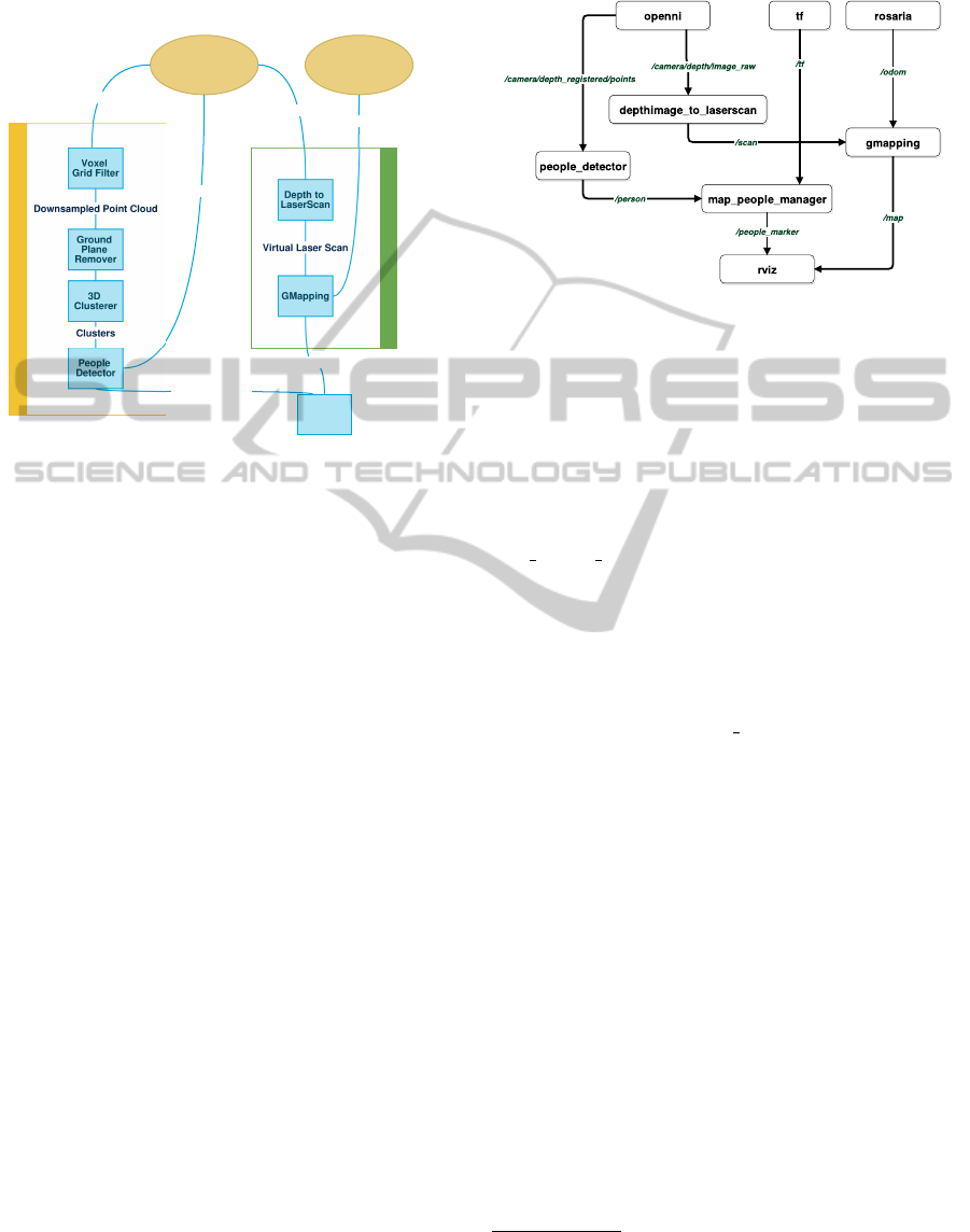
Figure 2: Summarized overview of the system in ROS.
Boxes refer to ROS nodes and arcs to topics.
3.3 Integration
Although both modules run in the same system, their
data is not in the same reference frame: detections
are made on the Kinect frame which is different from
the reference frame of the map. To deal with this is-
sue, we created a an additional ROS node (see node
map people manager in Fig. 2) that subscribes to the
detections, transforms their coordinates to map coor-
dinates, using ROS tools, and manages the detections,
avoiding multiple detections of the same person in the
same position. Also, it publishes the corresponding
markers to allow the visualization of the map and the
detections on the real relative position in the map. The
significant portion of the rqt graph is of the ROS sys-
tem is presented if 2.
4 EXPERIMENTAL SETUP AND
VALIDATION
In order to validate the people detection and mapping
solution, we used the experimental setup depicted in
Fig. 3, with the addition of a laptop on the robot’s plat-
form. The Kinect sensor was tilted 8
◦
up so that the
operating range for people detection is not affected
by the relative position to the ground plane, i.e. point
clouds will contain the whole person instead of half
body at closer distances. The test scenario was indoor
and was located in AP4ISR lab of the Institute of Sys-
tems and Robotics of the Univ. of Coimbra (ISR-UC).
Our experimental work was divided into three stages:
mapping method validation, people detection valida-
tion, and integrated system validation.
3
The SVM was trained using the well known INRIA Per-
son Dataset. (URL: http://pascal.inrialpes.fr/data/human)
ICINCO2014-11thInternationalConferenceonInformaticsinControl,AutomationandRobotics
470
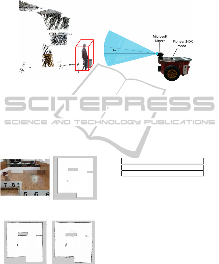
Figure 3: Mobile Robot (Pioneer 3-DX) with a Microsoft Kinect mounted on top.
4.1 Mapping Validation
In order to validate the mapping task with the Kinect
sensor, we attached to our robot a Hokuyo URG-
04LX-UG01 LRF to produce maps to be compared
with the ones obtained using the Kinect and the
method described in sec. 3.1. The environment tested
was a lab arena with approximately 4.6 × 4.0m, as il-
lustrated in Fig. 4. The robot was teleoperated using
an ssh remote connection, while running GMapping.
Figure 4: Photo of the test area (left) and ground truth map
(right).
Figure 5: Maps produced with the Hokuyo URG-04LX-
UG01 LRF sensor (left) and the Kinect sensor (right).
By visually comparing both maps, in Fig. 5, it be-
comes evident that the Kinect is not as accurate as the
LRF and that its limited FoV, range, and lower accu-
racy have a negative impact on the results obtained.
Nevertheless, both maps are easily interpretable by
the human eye. We computed the absolute pixel-wise
matching of all pixels in the maps generated to assess
their quality, and obtained acceptable matching rates,
as shown in Table 1. In order to compute the match-
ing metric, we binarized the maps obtained and the
ground truth, calculated the best fit alignment by ro-
tating the maps, and computed the pixel-wise match
of each pixel in the image.
Table 1: Pixel-wise matching rates.
Maps Matching Rate
Ground truth - Laser 96.9 %
Ground truth - Kinect 94.3 %
4.2 People Detection Validation
Despite the availability of some datasets, they do not
comply with the constraints and our hardware setup in
Fig. 3, mostly because the Kinect is only 24cm above
the ground, so it is tilted up to acquire visual informa-
tion containing people. In order to validate our people
detection method, we captured a dataset of about 100
frames that was manually annotated with the people
present in each frame. It contains one person walk-
ing in several directions at a distance of 1 to 4 meters
to the camera frame (an example is shown in Fig. 6).
Therefore, we have a dataset of binary decision. This
way, we were able to acquire data in similar condi-
tions to the final intended applications.
We applied the people detection method imple-
mented in ROS to process point clouds of the dataset,
and extract results (true positives, true negatives, false
positive and false negatives) in Receiver Operating
Characteristic (ROC) curves (see Fig. 7 and Fig. 8).
The ROC curve is a graphical plot which illustrates
Real-timePeopleDetectionandMappingSystemforaMobileRobotusingaRGB-DSensor
471
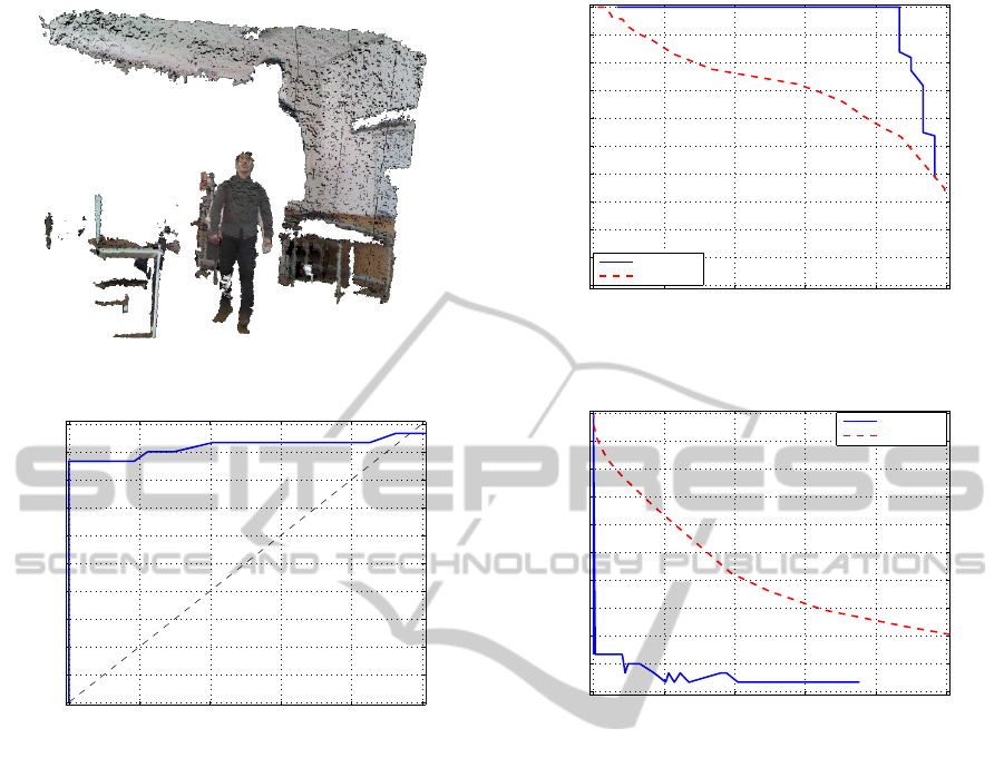
Figure 6: Example of a point cloud from the dataset.
0 0.2 0.4 0.6 0.8 1
0
0.1
0.2
0.3
0.4
0.5
0.6
0.7
0.8
0.9
1
False Positive Rate
True Postive Rate
Figure 7: ROC curve on our dataset.
the performance of a binary classifier system as the
discrimination threshold is varied.
Afterwards, we applied the method to cross val-
idate with the Kinect Tracking Precision (KTP)
Dataset from (Munaro et al., 2012), which contains
sequences of multiple people captured from a static
camera.
Fig. 7 relates the True Positive and False Positive
Rates (TPR and FPR). Perfect results are near the top
left corner with 0% FPR and 100% TPR. Fig. 8 shows
the precision and recall percentages for each exper-
iment. The ideal result is situated on the top right
corner with 100% recall and precision. Fig. 9 is the
Detection Error Tradeoff (DET) curve which relates
the False Rejection Rate (FRR) in percentage and the
number of False Positives per Frame (FPPF). The best
result is located on the bottom left corner.
We observed in the results obtained with our
dataset that the method is very robust in terms of false
negatives, showing a low FPR for high enough TPR,
e.g. 86.87% TPR for ≈ 0.00% FPR. This is also visi-
ble in the high precision shown in Fig. 8, even for high
recall values, e.g. 100% precision for 86.67% recall.
0 0.2 0.4 0.6 0.8 1
0
0.1
0.2
0.3
0.4
0.5
0.6
0.7
0.8
0.9
1
Recall
Precision
Our Dataset
KTP Dataset
Figure 8: Precision-Recall for our dataset and for the KTP
dataset.
0 0.2 0.4 0.6 0.8 1
0
0.1
0.2
0.3
0.4
0.5
0.6
0.7
0.8
0.9
1
FPPF
FRR
Our Dataset
KTP Dataset
Figure 9: Detection Error Tradeoff (DET) for our dataset
and for the KTP dataset.
We were able to achieve an accuracy of 92.98% which
shows the reliability of the method.
Note however that this analysis is performed inde-
pendently for each processed point cloud (each frame
provided by Kinect). In real world applications, with
depth data from Kinect at 30 fps, we will capture sev-
eral frames for each person, which allows us to gain
certainty when detecting a person in short time inter-
vals. In the case of SaR missions, it is very impor-
tant to lower the false positives as much as possible
to avoid wasting resources and time while keeping a
high FPR to be capable of detecting all the victims.
The low number of frames and the presence of
only one person is clear in the curves and led us to
run the method with the KTP dataset. The results ob-
tained on the KTP dataset were comprehensively not
as good as the ones with our dataset, since the former
is a more complex dataset containing up to 5 peo-
ple in the same sequence. Still, the accuracy of the
method for a single frame is enough considering the
amount of frames available that we can process for
detecting each person. We did not compute the ROC
curve for this dataset because it aims to assess a bi-
ICINCO2014-11thInternationalConferenceonInformaticsinControl,AutomationandRobotics
472
nary classification problem and it barely contains bi-
nary decisions due to the nature of the tracking prob-
lem. Still, we can conclude from the Precision-Recall
and DET curves that the results are accurate enough
for our intended applications, e.g. 72.39% precision
for 57.51% recall and 0.39 FPPF for 42.49% FRR.
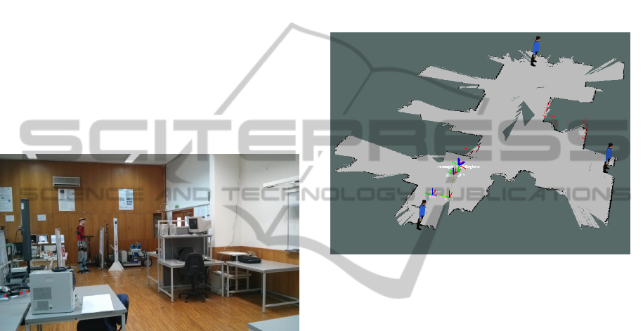
5 EXPERIMENTAL TESTS WITH
A MOBILE ROBOT
To validate the system, we used the previously pre-
sented setup in an indoor uncontrolled and cluttered
environment in the AP4ISR lab of ISR-UC. The envi-
ronment contains desks, tables, placards, chairs, hard-
ware and all kinds of objects (see Fig. 10). The sys-
tems performed all the computation and also displays
the results in real-time.
Figure 10: Photo of the environment used to test the whole
system.
The environment was reliably mapped (see
Fig. 11). We note that the 2D mapping method uses
the desks top edges in the mapping so the space un-
der them are not considered due to the point cloud
downsampling. On the other hand, for people detec-
tion purposes, the whole space is considered, there-
fore if a detection is made under a table, it would still
be represented in the map.
In our experiments, we used three subject stand-
ing on different locations, two real humans (one male
and one female) and a human model (seen in Fig. 10).
In all experiments, the robot was able to map fairly
accurately and detect all of them. Fig. 11 shows a
picture of the ROS visualization software rviz with
the ongoing construction of the map and the detec-
tions made so far. The experiment depicted lasted 4,3
minutes. The robot was teleoperated with a Wii Re-
mote Control connected via bluetooth to the laptop
mounted on top of the robot. The system depicted
in Fig. 1 and in Fig. 2 was run on a laptop with an
Intel Core i7-4700MQ CPU, 16GB of RAM, Ubuntu
12.04, and ROS Hydro. We computed the average
CPU load along the experiment, which resulted in
44.71% of CPU usage and an average of 16.07 fps was
processed. This frame rate could be increased through
the parallelization of the code in a GPU. Also the
results demonstrate that the system performs well in
real word scenarios and its computational load leaves
room to incorporate further modules in the system,
such as additional sensory cues, e.g. audio input, and
perform other tasks in parallel, such as autonomous
navigation and exploration.
Figure 11: Map obtained and people detected.
6 CONCLUSION
This paper proposed an integrated system that is able
to successfully map the environment, localize the
robot with respect to the map and, simultaneously, de-
tect and localize people within the environment, while
relying solely in a RGB-D sensor. However, we in-
tend in our future work to have a system that is also
able to autonomously explore the environment. This
will probably require an upgrade of the current hard-
ware setup of Fig. 3, due to the narrow FoV of the
Kinect which may cause unreliable navigation. Also,
our goal is a system that can be used to perform SaR
missions, the robot should be able to navigate towards
victims, to eventually interact with them. We intend
to study the use of a second Kinect sensor to achieve
a wider FoV. This improvement does not imply great
costs and should yield a safer navigation.
In the future, we also intend to take advantage of
other capabilities of the Kinect sensor, such as pro-
cessing audio information from its microphone array
to improve people detection results. Furthermore, we
would like to test the system in other applications
such as automated patrolling and surveillance with
robotic teams (Portugal and Rocha, 2013).
Real-timePeopleDetectionandMappingSystemforaMobileRobotusingaRGB-DSensor
473

REFERENCES
Bajracharya, M., Moghaddam, B., Howard, A., Brennan,
S., and Matthies, L. H. (2009). A fast stereo-based
system for detecting and tracking pedestrians from a
moving vehicle. Int. Journal of Robotics Research,
28(11-12):1466–1485.
Clemente, L., Davison, A., Reid, I., Neira, J., and Tard
´
os,
J. D. (2007). Mapping large loops with a single hand-
held camera. Proc. Robotics: Science and Systems
Conf.
Dalal, N. and Triggs, B. (2005). Histograms of oriented
gradients for human detection. Int. Conf. on Computer
Vision & Pattern Recognition, 2:886–893.
Dissanayake, M. G., Newman, P., Clark, S., Durrant-
Whyte, H. F., and Csorba, M. (2001). A solution to the
simultaneous localization and map building (SLAM)
problem. Rob. & Automation, IEEE Tr. on, 17(3):229–
241.
Droeschel, D., May, S., Holz, D., Ploeger, P., and Behnke,
S. (2009). Robust ego-motion estimation with ToF
cameras. European Conf. on Mobile Robots, pages
187–192.
Ferreira, J. F., Lobo, J., Bessi
`
ere, P., Castelo-Branco, M.,
and Dias, J. (2013). A Bayesian framework for active
artificial perception. IEEE Trans. on Cybernetics (Part
B), 43(2):699–711.
Fischler, M. A. and Bolles, R. C. (1981). RANdom SAmple
Consensus: a paradigm for model fitting with appli-
cations to image analysis and automated cartography.
Comm. of the ACM, 24(6):381–395.
Grisetti, G., Stachniss, C., and Burgard, W. (2007).
Improved techniques for grid mapping with Rao-
Blackwellized particle filters. IEEE Trans. on
Robotics, 23:2007.
Henry, P., Krainin, M., Herbst, E., Ren, X., and Fox, D.
(2010). RGB-D mapping: Using depth cameras for
dense 3D modeling of indoor environments. Experi-
mental Robotics, 79:477–491.
Keller, C. G., Enzweiler, M., Rohrbach, M., Fernan-
dez Llorca, D., Schnorr, C., and Gavrila, D. M. (2011).
The benefits of dense stereo for pedestrian detection.
ITS, IEEE Trans. on, 12(4):1096–1106.
Konolige, K. and Agrawal, M. (2008). FrameSLAM:
From bundle adjustment to real-time visual mapping.
Robotics, IEEE Trans. on, 24(5):1066–1077.
Kuemmerle, R., Grisetti, G., Strasdat, H., Konolige, K., and
Burgard, W. (2011). g2o: A general framework for
graph optimization. ICRA, pages 3607–3613.
Levi, K. and Weiss, Y. (2004). Learning object detection
from a small number of examples: the importance of
good features. CVPR, pages 53–60.
Llorca, D., Sotelo, M., Hell
´
ın, A., Orellana, A., Gavilan,
M., Daza, I., and Lorente, A. (2012). Stereo regions-
of-interest selection for pedestrian protection: A sur-
vey. Transportation research part C: emerging tech-
nologies, 25:226–237.
Lowe, D. G. (2004). Distinctive image features from scale-
invariant keypoints. Int. Journal Computer Vision,
60(2):91–110.
May, S., Droeschel, D., Holz, D., Fuchs, S., Malis, E.,
N
¨
uchter, A., and Hertzberg, J. (2009). 3D mapping
with ToF cameras. Journal of Field Robotics, sp. is-
sue on 3D Mapping.
Menezes, P., Brethes, L., Lerasle, F., Danes, P., and Dias, J.
(2003). Visual tracking of silhouettes for human-robot
interaction. pages 971–976.
Michael Calonder, Vincent Lepetit, and Pascal Fua (2008).
Keypoint signatures for fast learning and recognition.
In European Conf. on Computer Vision.
Munaro, M., Basso, F., and Menegatti, E. (2012). Tracking
people within groups with RGB-D data. IROS, pages
2101–2107.
Portugal, D. and Rocha, R. P. (2013). Distributed multi-
robot patrol: A scalable and fault-tolerant framework.
Robotics & Auton. Syst., 61(12):1572–1587.
Premebida, C., Ludwig, O., and Nunes, U. (2009). Lidar
and vision-based pedestrian detection system. Journal
of Field Robotics, 26(9):696–711.
Prusak, A., Melnychuk, O., Roth, H., Schiller, I., and Koch,
R. (2008). Pose estimation and map building with a
time-of-flight camera for robot navigation. Int. Jour-
nal Intell. Syst. Technol. Appl., 5(3/4):355–364.
Quigley, M., Conley, K., Gerkey, B. P., Faust, J., Foote, T.,
Leibs, J., Wheeler, R., and Ng, A. Y. (2009). ROS: an
open-source robot operating system. ICRA Workshop
on Open Source Software.
Rocha, R. P., Portugal, D., Couceiro, M., Araujo, F.,
Menezes, P., and Lobo, J. (2013). The CHOPIN
project: Cooperation between Human and rObotic
teams in catastroPhic INcidents. SSRR, pages 1–4.
Rosten, E. and Drummond, T. (2006). Machine learning
for high-speed corner detection. In European Conf.
on Computer Vision, pages 430–443.
Rusu, R. and Cousins, S. (2011). 3D is here: Point Cloud
Library (PCL). ICRA, pages 1–4.
Satake, J. and Miura, J. (2009). Multiple-Person Tracking
for a Mobile Robot Using Stereo. MVA Conf., pages
273–277.
Soni, B. and Sowmya, A. (2013). Victim detection and
localisation in an urban disaster site. ROBIO, pages
2142–2147.
Spinello, L. and Arras, K. O. (2011). People detection in
RGB-D data. IROS, pages 3838–3843.
Triebel, R. and Burgard, W. (2005). Improving simultane-
ous localization and mapping in 3D using global con-
straints. AAAI, 20(3):1330.
Triggs, B., Mclauchlan, P., Hartley, R., and Fitzgibbon, A.
(2000). Bundle adjustment – a modern synthesis. Vi-
sion Algorithms: Theory and Practice, LNCS, pages
298–375.
ICINCO2014-11thInternationalConferenceonInformaticsinControl,AutomationandRobotics
474
