
Police Response Officer Selection
Development of Tool to Aid the Dispatch of Police Response Officers
Johanna Leigh, Sarah Dunnett and Lisa Jackson
Department of Aeronautical and Automotive Engineering, Loughborough University, Loughborough, U.K.
Keywords: Police Response, Vehicle Routing, Multi Objective, Decision Making, Simulation.
Abstract: It’s essential the Police force use their resources to the highest possible efficiency to ensure adequate service
in the face of major funding cuts. Automation of the response officer selection process can improve
efficiency by assisting in selecting the most appropriate response officer to attend an incident. Currently
dispatchers are tasked with selecting the appropriate response officers to send to incidents. This may not
result in the most efficient officer being selected to attend an incident. Providing a software tool to assist in
the decision making process will decrease uncertainty in the decision and hence increase the likelihood of
the most efficient officer being selected to attend an incident. The selection considers response time,
availability, area coverage, driving standard and traffic conditions. The tool is specific to the police dispatch
process and hence accounts for factors which are not which general included in other dispatch tools.
1 INTRODUCTION
The UK police force is facing major funding cuts
which have led to an increasing focus on improving
the running efficiency of the service to ensure the
reduction in funding does not result in a decrease in
quality of service. One main area of concern is the
incident response service, as reducing the quality of
this service would lead to a reduction in public
safety. To keep this service running efficiently, with
reduced funding, improvements must be identified.
One means of increasing efficiency is to ensure that
the most appropriate officer is sent to an incident.
Currently dispatchers must make a fast decision on
which officer must attend each incident using the
information available. Due to a lack of information
the process does not always lead to the most
efficient officer being chosen. The work outlined in
this paper identifies the appropriate selection criteria
for response officers and uses this information to
develop a tool which can be used by dispatchers to
select the most appropriate response officer.
The tool consists of three major elements,
mapping, routing and decision making. The mapping
tool shows the road map of the geographical location
of interest. The routing tool uses the map to
determine the routes officers can take to incidents,
this enables the officer who would reach the incident
in the shortest time to be identified. In determining
these routes the tool currently takes into account the
types of roads and predicted traffic conditions using
road weightings. The decision tool then determines
the most suitable officer to attend an incident taking
into account many factors, as when selecting an
officer the quickest route is not the sole
consideration. Other considerations include officer
availability, effects on area coverage and drivers
driving qualification, these are all considered in the
current decision tool. The tool aims to decrease
uncertainty in the dispatcher’s decision making
process and increase the probability of selecting the
most appropriate officer. It is developed specifically
for police officer dispatch by considering details
such as effects of driving qualification and form of
transport.
In this paper initially a background to the present
study is given and past relevant work is discussed.
The three elements of the officer selection tool
identified previously and how they are implemented
in the tool developed here are then described in more
detail. The final stage of the paper details how
discrete event simulation is used to test the effects
the tool has on the dispatch process. The results can
be verified by comparing them to the current process
for selecting an officer to attend an incident.
Details of policing activities have been taken
from Leicestershire police. In other police forces
processes may vary slightly.
407
Leigh J., Dunnett S. and Jackson L..
Police Response Officer Selection - Development of Tool to Aid the Dispatch of Police Response Officers.
DOI: 10.5220/0005285104070412
In Proceedings of the International Conference on Operations Research and Enterprise Systems (ICORES-2015), pages 407-412
ISBN: 978-989-758-075-8
Copyright
c
2015 SCITEPRESS (Science and Technology Publications, Lda.)

2 BACKGROUND
When incidents are reported they are assigned a
grade which is typically between one and four.
Grades one and two require an officer to be sent
within a certain time limit. Grades three and four
can be dealt with over the phone or by a scheduled
appointment. Grade one incidents are emergencies
which require response within fifteen minutes.
Incidents that qualify include when there is a danger
to life or immediate threat of violence. Grade two
incidents are priority situations which require
response within sixty minutes. Incidents which
qualify include those where a caller is vulnerable.
Police officers are assigned to grade one and two
incidents by a dispatcher. The dispatcher allocates
the police officers as they see fit. When allocating
officers to incidents they aim to minimise the
response time and increase availability and area
coverage. Response time is defined as the time
between the call being answered and officers
reaching the location of the incident. The availability
is defined as the time officers are free to patrol. Area
coverage is the number of officers able to reach a
location within response time guidelines.
Dispatchers often don’t have all the information to
make an informed decision of which officer to send
to an incident and hence ask officers who can attend.
This method typically does not result in the most
suitable officer being selected for maximised
efficiency of resources.
Current research in this area is limited. There are
many other services and businesses which dispatch
resources to locations. These include other
emergency services, maintenance engineers and
taxis. There is more extensive research in these areas
of dispatch than in police dispatch. These studies are
relevant but cannot be used due to the specific
decisions involved in police officer selection.
2.1 Emergency Service Dispatch
Due to its importance there has been some previous
research into the emergency service dispatch
process. The majority of this work has considered
the ambulance and fire services.
The ambulance service faces similar issues to the
police force as they need to deploy their ambulances
to incidents with the highest efficiency. Their aim is
to reach each situation in the shortest period of time.
Extensive studies have been carried out to ensure
efficient positioning of ambulances, for example
(Henderson & Mason, 2004), (Haghani et al, 2003)
and (Bandara et al, 2013). The study by (Henderson
& Mason, 2004) states that the ambulance service
also lacks a dispatch support tool. In this study
decisions were made on dispatching ambulances and
locating ambulances and stations. The ambulance
service planning software ‘BARTSIM’ was
developed to analyse information and simulate
results. The software was implemented in an
ambulance service in Australia.
(Haghani et al, 2003) developed a dispatch tool
for the ambulance service. The tool included;
flexibility in assignment to allow reallocation of
resources as conditions changed, real time traffic
information and weightings to cases depending on
their priority, to give preference to attending more
severe incidents. The computational time of this
process was a major issue as results are required
quickly in emergency situations.
The recent study on the ambulance service by
(Bandara et al, 2013) explained the difficulties
incurred in dispatching the appropriate ambulance to
attend an incident. It explains that the closest
ambulance should not always be selected as it is not
always optimal to aim to minimise the average
response time. Also ambulances shouldn’t be
assigned on a first-come-first-served basis. When
considering selection the severity of the incident and
the effects on area coverage should be considered. In
this case the area coverage is measured by the
number of demand points that can be met by the
paramedic units within the set response time.
A relevant study into the fire service dispatch
process by (Ignall et al, 1982) looked to reduce the
second vehicle response to severe incidents
requiring more than one fire engine. Historical data
was used to predict how many fire engines would be
required.
3 METHOD
The tool developed here has three sections; a
mapping system, route finder and decision maker.
The mapping system details the possible paths which
can be travelled on. The route planner finds the
appropriate routes between officers and incidents.
The decision tool selects the officer depending on
factors such as availability and driving standard.
These sections will now be described in more detail.
3.1 Mapping
In order to enable effective officer selection it is
necessary to have a road network model in which
officers and incidents can be positioned and routed.
ICORES2015-InternationalConferenceonOperationsResearchandEnterpriseSystems
408
The road information needs to be adaptable to allow
information to be changed such as the speed possible
along roads. To allow for this adaptability a road
map will be created using information available
from OpenStreetMaps (OpenStreetMaps, 2014) such
as the longitudinal and latitude points along roads.
From this information it is possible to model the
map as a directed graph using Equation 1:
G = (V, E) (1)
This equation uses a group of vertices (V) to
represent the longitude and latitude points given as
points along a road and uses edges (E) to represent
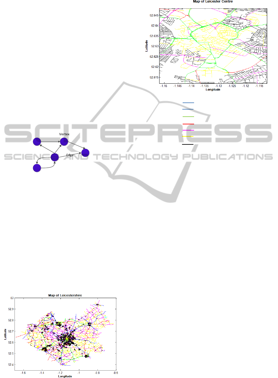
the roads which join the vertices. Figure 1 shows
how this is represented in graph form. The graph is
directed because roads may be one-way and hence
can only be travelled in one direction; this direction
is represented by the arrows.
Figure 1: Directed graph.
Each edge has an associated weighting to
account for the cost of travelling on the edge. The
cost in this case is time, which will be considered
when finding the appropriate route to travel.
From the data provided vertices are plotted and
joined by the edges to create roads. This is used to
develop a map for the entirety of the area of interest.
Figure 2 is the road map of Leicestershire produced
and Figure 3 is a zoned in section of Leicester centre
plotted. The colour of the road illustrated the type of
road, further information can be found in the key.
Information such as direction of the roads and
weightings are contained within matrices within the
mapping tool.
Figure 2: Road map of Leicestershire.
Colour Road type
Motorway
Trunk road
Primary
Secondary
Tertiary
Unclassified
Residential
Figure 3: Map of central Leicester.
To navigate through the road system a method of
finding a path from a current location to a target
location is required, this is found through routing
which is detailed in the next section.
3.2 Routing
This section of the tool is to determine which officer
could reach an incident in the shortest time. In an
emergency the shortest response time is the main
objective for routing. Current methods of deciding
which officer to send to an incident consider the
closest officer which isn’t necessarily the quickest.
The predicted time for each officer to reach the
incident of concern is calculated by finding the
quickest path from officer to incident using
Dijkstra’s algorithm. The possible paths considered
are detailed on the map. The time taken to travel
along each section of the path is calculated using the
distance travelled along the road and the weighting
given to the road. The road weighting considers type
of road and predicted traffic and is discussed further
in section 3.3.4.
The route from every officer in Leicestershire to
an incident is not calculated. To save computational
time the officer must meet certain criteria to be
included in the routing process. For example, in an
emergency situation officers which are unavailable,
as they are busy with other duties, are excluded from
the search. Of those available the n closest officers
to the incident are found using simple ‘as a crow
PoliceResponseOfficerSelection-DevelopmentofTooltoAidtheDispatchofPoliceResponseOfficers
409
flies distance’ and these are the officers who are
considered. n in this case is taken to be four but
requires further testing to find the optimal value.
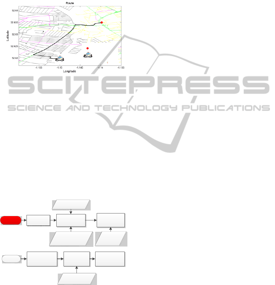
Figure 4 shows the route from an officer to an
incident determined by the tool. The route chosen
utilises main roads due to the road weighting system.
Figure 4: Route from officer to incident.
The quickest route isn’t the only consideration
when selecting an officer. Other criteria are
considered in the decision making tool.
3.3 Decision Criteria
The decision of which officer to select to attend an
incident is based on multiple factors including the
officer location, the officer availability and driving
standard, grade of the incident and area coverage at
the officer location. How each of these factors
impact the decision is discussed further in the
following subsections. Figure 5 shows the two
different selection criteria for emergency and
priority response.
Emergency
Whichofficers
areavailable
Whichofficerwill
gettoincident
quickest
Howmany
officersrequired
Priority
Officerwillget
totheincident
quickest
Typeofdriver :
Basic,standard
oradvanced
Currenttraffic
conditions
Currenttraffic
conditions
No.of
officersin
carorvan
Wouldmoving
officercreatelarge
areasuncovered
Officersavailablein
timetomeettarget
responsetime
Figure 5: Selection criteria.
The emergency situation decision considers
availability and the predicted response times
accounting for traffic and driving standard. The
priority situation considers availability, predicted
response time accounting for traffic and area
coverage.
3.3.1 Response times
The grade of an incident determines the response
time target. The response time targets are set by the
government as fifteen minutes for a grade one and
sixty minutes for a grade two, where grade one is an
emergency situation and grade two is a priority
situation. All other grades are sorted on the phone or
by a scheduled meeting. The tool developed here is
useful for incidents classed as grade one and grade
two, as these both require dispatchers to send an
officer in a timely response.
3.3.2 Availability
Officers have varying availability status markers
depending on what they are currently undertaking.
These can include available, attending to incident,
break, etc. Available officers are ready to be sent to
perform a task. Officers attending to incident are not
available and the time they become available is hard
to predict, officers on a break are unavailable though
the time they become available can be predicted.
The status markers are used to determine
whether an officer can be selected to attend an
incident. In emergency situations a response is
required immediately hence available officers are
the only option. In priority situations response is not
required immediately hence officers who are
predicted to become available in the time window
can also be selected. Of all the status markers,
officers on a break and those processing prisoners
are the two for which the time at which they become
available can be predicted. The use of this factor as a
selection criterion depends on the reliability of
officers remembering to update their status.
3.3.3 Driving Standard
There are currently three main driving standards for
police officers. There are basic drivers; which allows
the officer to drive at the road speed limit. There are
standard drivers; which allows the driver in
emergency situations to use blue lights and sirens
and go above the given speed limit (typically limited
to 20mph over). And finally there are advanced
drivers who can do the same as a standard driver
with the addition of pursuing cars which fail to stop.
Hence in an emergency situation a standard or
advanced driver who is further away from the
incident than a basic driver may be able to reach the
incident quicker. Therefore in an emergency
Incident
Officer
ICORES2015-InternationalConferenceonOperationsResearchandEnterpriseSystems
410

situation, when predicting the time taken to travel
the route, the driving qualification of the officer
driving is considered. The road weightings for a
basic driver remain the same as in a priority
situation. The road weightings for standard and
advanced drivers are reduced to account for the
increase in speed and parting of traffic. These road
weightings are discussed further in section 3.3.4.
3.3.4 Road Weightings
Road weightings are applied to roads to give
preference to travelling on particular roads and give
a fair indication of how long each route will take to
travel for comparison with other officer’s routes.
These weightings allow road type and traffic to be
accounted for. This is necessary as road type
determines the speed which vehicles can travel on
the road under normal road conditions and the traffic
conditions determine the speed which vehicles can
travel down a road during congested times. The
distance travelled along the road is multiplied by the
road’s weighting to give a more accurate prediction
of the time taken to travel along the road. Road type
has a constant effect on the road due to speed limits
and hence the weighting associate with this is
constant. Traffic varies depending on many factors
such as time of day, day of the week, season and
accidents and hence traffic weightings will vary
depending on these factors. Accidents can’t be
predicted and hence won’t be accounted for in the
weighting system.
Different weightings are given officers on foot or
bike so they can also be considered in the decision
process. Whilst routing paths are considered where
in vehicles they are not considered.
3.3.5 Area Coverage
Area coverage is the level of officers who are
present in an accessible location to the area
considered. The area coverage of a road is measured
by the ability of an officer to reach it within the set
response time limits. This officer doesn’t have to be
available, only present in the area where coverage is
required. The level of coverage in an area can be
determined by how many of the officers could reach
a road within the limits of the response time. For
example if two vehicles could reach the road the
area coverage is two. The possible demand is
determined using historical data in each area. Those
areas with a demand of one should maintain an area
coverage level of one.
When selecting an officer to attend an incident the
dispatcher should seek to maintain appropriate area
coverage and not remove all officers from an area.
Within the tool it will recommend not moving
officers if a large area will be left uncovered.
3.4 Simulation
The use of simulation allows the effects of using the
tool developed to be analysed before implementation
into a dispatch team. This is vital as it’s too high risk
to implement into the police force without
validation.
To simulate the use of the officer selection tool a
model of the process which requires the tool is set
up. The simulation runs through a period of time
where incidents occur and uses the tool to decide
which officer should attend each of these incidents.
Information input into the model such as incident
data etc has been taken from historical data from
Leicestershire Police. These scenarios test the
decision making capabilities of the tool. The results
of the decision are to be compared to real life
statistics for average incident response times and
officer availability.
The simulation is a discrete event simulation
where an event is an incident occurring. The
incidents are at variable time increments hence it is a
variable time step simulation. This means the
simulation will skip periods where incidents are not
occurring which leads to a more efficient simulation.
Figure 6 shows the simulation process. Initially
the map of the area of interest is created using data
from OpenStreetMaps, following this the testing
period is set and incident data for this period is
generated. The incidents then trigger the simulation
to run the decision making process to determine
which officers to send to the incident. The selection
runs through different criteria depending on whether
the incident is classed an emegency or priority
incident by the system. When making a decision,
information from the resource list is used to
determine where officers are currently located and
their status and driving ability. Once an officer is
selected their status is updated on the resource list
and the next incident is inserted into the simulation.
For the purpose of the simulation the time the officer
will be undertaking this task is set using historical
information of that type of incident. When using the
tool in the field the officer status will be set to
‘attending incident’ until they update their status.
The simulation records information on response
times, distance travelled by each officer and
availability for the purpose of analysis.
PoliceResponseOfficerSelection-DevelopmentofTooltoAidtheDispatchofPoliceResponseOfficers
411

Figure 6: Simulation process.
4 RESULTS
Preliminary findings from the simulation show
significant differences in efficiency between using
the decision tool to determine which response officer
should attend an incident and selecting a random
officer to attend an incident. The response times are
lower, distance travelled by vehicles is lower and
availability is increased. This shows an increase in
efficiency in the police response service.
5 CONCLUSIONS
A need for an officer dispatch tool has been
expressed by multiple police forces. To identify this
issue a tool has been developed which can be used to
select the most appropriate officer to send to an
incident. The tool takes into account factors which
are not currently used in the dispatch process which
improve the likelihood of selecting the most efficient
officer. The initially results show an increase in
officer efficiency and prove this tool worthy of
further development and implementation.
6 FUTURE WORK
Further work will include improvement to road
weightings by using live traffic information to set
weightings. This will give a more accurate idea of
the traffic conditions and allow accidents to be
accounted for. Also a queuing process to priorities
series incidents will be included.
ACKNOWLEDGEMENTS
The cooperation of the Leicestershire police force is
gratefully acknowledged as without this support this
project would not be possible. This work was
supported by the Economic and Social Research
Council [ES/K002392/1].
REFERENCES
Bandara, D., Mayorga, M., McLay, L., 2013. Priority
dispatching strategies for EMS systems. Journal of the
Operational Research Society, Volume 65, Issue 10.
Haghani, A. Hu, H., Tian, Q, 2003. An Optimization
Model for Real-Time Emergency Vehicle Dispatching
and Routing. Transport Research Board.
Henderson, S., Mason, A., 2004. Ambulance Service
Planning: Simulation and Data Visualisation.
International Series in Operations Research and
Management Science, Volume 70.
Ignall, E., Carter, G., Rider, K., 1982. An Algorithm for
the Initial Dispatch of Fire Companies. Management
Science, Volume 28, Issue 4.
OpenStreetMaps & Contributors. (2014). Maps. Available:
http://www.openstreetmap.org/. Last accessed
01/09/2014.
ICORES2015-InternationalConferenceonOperationsResearchandEnterpriseSystems
412
