
Socializing Public Transportation
Using Situational Context in Public Transportation to Get in Touch with People
Around You
Roman Roor, Olga Birth, Michael Karg and Markus Strassberger
BMW Group Forschung und Technik, Hanauer Str. 46, Munich, Germany
Keywords:
Mobility Patterns, Public Transport, Socializing, Micro Social Network, Recommendation.
Abstract:
Unexpected delays or long traveling times lead often to people who get bored while using public transport.
Whereas some might use their travel time for work or even enjoy the silence, there are still many people that
would welcome an opportunity to use the spatio-temporal proximity to get to know others or meet with friends
that are in the same train. This paper introduces a novel, smartphone based concept to bring people together
while using or waiting for public transport. Based on location and personal preferences, suggestions can be
made for getting in touch with nearby persons. We propose a recommendation system, which identifies the
concrete public transport vehicle and compares the preferences with other users to create recommendations
about people nearby who are also traveling in or waiting for a public transport vehicle.
1 INTRODUCTION
With the megatrend of increasing urbanisation around
the world, more and more people are expected to use
public transportation in the near future. Due to unex-
pected delays or problems on public transport lines,
frequent use of transportation modes like subways,
trains or buses inevitably leads to planned or even un-
expected waiting times at stations, bus stops or sim-
ilar. In particular trips including multiple vehicles
or modes of transport can be subject to unexpected
waiting times due to the possibility of missing a con-
nection trip. Waiting times of up to 30 minutes are
not uncommon, especially when traveling late at late
evening. Commonly, most people waiting at e.g. train
stations today just try to fight their boredom by play-
ing smartphone games or similar. But the upcom-
ing boredom can not only be observed when wait-
ing on e.g. a train or plane, but also during a trip.
While some people might use their travel time for
work or even enjoy the silence, there are still many
people in e.g. a train that are bored and would wel-
come an opportunity to use the spatio-temporal prox-
imity to other bored persons to get to know other peo-
ple or meet with friends that are in the same train.
The missing link to bringing together people with the
same temporal interests is the uncertainty of the in-
tents of the people around, respectively in the same
train. Once this inhibition threshold is overcome by
connecting people with same interests travel or wait-
ing times can be used for socializing instead of be-
ing bored. Due to overall penetration of smartphones
and internet connectivity – even in the subway and on
planes – people are always connected to each other
anywhere. This is an excellent precondition to bring
traveler together. Since built-in smartphone compo-
nents can be used to track nearby traveler, sugges-
tions can be made about friends or other traveler in
the same vehicle, that are available for chatting. This
paper introduces a novel, smartphone based concept
to bring people together while using or waiting for
public transport. Based on location and personal pref-
erences, suggestions can be made for getting in con-
tact with nearby persons. We propose a recommenda-
tion system, which compares location data and prefer-
ences with other users and creates recommendations
about people nearby. This opens up a variety of new
possibilities. For instance, a person missing a con-
necting train can easily experience waiting times of
up to 2 hours until the next train to the destination.
Finding people in a similar situational context could
not only lead to less boredom during waiting time, but
also to shared rides to a common destination. Gener-
ally speaking, our approach enables the use of random
occasions to meet people.
113
Roor R., Birth O., Karg M. and Strassberger M..
Socializing Public Transportation - Using Situational Context in Public Transportation to Get in Touch with People Around You.
DOI: 10.5220/0005492201130118
In Proceedings of the 1st International Conference on Vehicle Technology and Intelligent Transport Systems (VEHITS-2015), pages 113-118
ISBN: 978-989-758-109-0
Copyright
c
2015 SCITEPRESS (Science and Technology Publications, Lda.)
2 RECOMMENDATION SYSTEM
Almost every second person living in Germany has
a smartphone today (data from May 2014, (Statista,
2014)), and generally, the number of smartphone us-
age is increasing. Most smartphones have various
kinds of sensor components built in, which can be
used for location tracking. With rising smartphone
usage, services like texting, social network apps and
app usage in general, provide a good basis for loca-
tion and preference based recommendation systems
(Lenhart, 2012). So there is no need for additional
devices, which could be a barrier.
Also the fact that (long distance) public transport
is often delayed or even spontaneously canceled con-
firms that a recommendation system for bored trav-
eler is a promising concept (AFP/woz, 2010), (Bahn,
2014). In addition, different statistics show that ride
sharing is growing in North America and in Eu-
rope (Chan and Shaheen, 2012), (BlaBlaCar, 2012).
Establishing a real time ride sharing network could
also reduce CO2 pollution. Mobile apps like Tinder,
Lovoo, Grindr and Cuddlr demonstrate that geolo-
cation based matchmaking has a huge potential. 11
times a day on average, people use such kind of apps
and spent between 7.2 and 8.5 minutes per login using
the app (Bilton, 2014). Combining the idea of match-
making with an recommendation system for travelers,
based on short geolocation distance with an intelligent
algorithm for finding potential conversation partners
with the same transportation route and preferences, a
solution for potential boredom during trips can be cre-
ated.
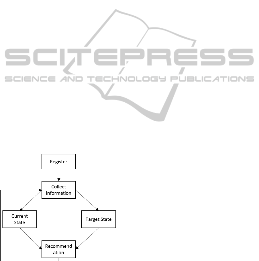
Figure 1: Workflow Recommendation System.
We propose a recommendation system based on
the workflow shown in figure 1. First of all the user
needs to set some preferences according to the at-
tributes of the desired user group. As soon as the sys-
tem knows the user, the person can plan routes while
the system continuously keeps track of the user’s lo-
cation. By gathering information the system can es-
timate the current and target state. By merging the
states and evaluating the differences, recommenda-
tions are made.
2.1 Micro Social Network
One focus of the proposed idea is to connect people
considering their personal preferences. To make it
work, we need to know who the people are. So ev-
ery user needs to register at the service and partici-
pate within the network. It is also conceivable to of-
fer registration using OAuth / connect APIs of major
social networks to be able to collect more information
and preferences and reduce configuration costs for the
user. Intelligent suggestions can only be made if the
service knows the bias of the users.
The intention is not to create another social net-
work where the users maintain their profiles addition-
ally to the existent major social networks but only
provide a minimum set of their bias and one or more
photos. This micro social network is more provider
driven to be able to build graph based databases about
social contacts according to users who are friends and
potential matches while the user is being tracked.
The way to connect others is to press ”Like” on
target profile. Only after the user behind the targeted
profile also has pressed ”Like” they are connected and
can start to communicate. The targeted user does not
know in advance if he/she was liked.
2.2 Habits
Humans tend to pattern daily actions into sequences
which they repeat at particular times in particular
places (Townsend and Bever, 2001). Furthermore,
most people spend a large proportion of their time at
just a few locations, of which the home of a person
as well as his/her workplace(s) have a high impact
(Herder et al., 2014), (Song et al., 2010), (Gonzalez
et al., 2008). Such regularities in persons’ mobility
patterns can be used to predict likely next locations
of a person as well as the corresponding route and
mode of transport that is taken to the destination. To
perform such predictions, there exist various methods
based on heuristics (Froehlich and Krumm, 2008),
different variants of Bayesian networks (Simmons
et al., 2006) or similar. Most of the approaches use
motion tracking data from smartphone sensors and
apply different clustering algorithms about commonly
visited locations, such as a persons home and work-
VEHITS2015-InternationalConferenceonVehicleTechnologyandIntelligentTransportSystems
114

place. Furthermore, statistical models about spatio-
temporal relations between locations are generated to
enable predictions of likely next locations of a person
as well as the corresponding departure time, mode of
transportation and the used routes.
Figure 2: Two different persons traveling the same section
at the same time.
Such information about habitual trips of a person
can be used to intelligently create recommendations
for possible meetings with people, the user is con-
nected with. Figure 2 illustrates a situation in which
such a recommendation could be useful. Person A
usually leaves his/her home at around 10:51am each
Saturday to visit his/her grandmother by train. Person
B, to whom person A is connected by the micro social
network (as described in section 2.1), joined the same
train earlier at 10:42am with the same destination. In
this case, our system could inform both persons about
a possible meeting opportunity. The same scenario
would not only be thinkable for routes with the exact
same destination, also routes with partial similarities
are possible candidates for meetings.
3 IDENTIFICATION OF
CONTEXTUAL DATA
To make our proposed idea work, we need to know
two additional things about the person using our sys-
tem. On the one hand, we need to have a better under-
standing of the localization of a person who is using
public transportation. On the other hand, our system
should be aware of the remaining time the particular
person will spend traveling in or waiting for bus, train
etc. First we will describe, how we can identify the
precise localization of a person using different types
of public transport. Further we will take a closer look
on how we manage to get the remaining travel time.
3.1 Localization
As we suggest a solution, which notifies a person
about possible passengers or friends who are also
traveling in a particular public transport vehicle and
are also looking for a conversational partner, our sys-
tem should be able to identify the concrete means
of transport in which those two people are traveling.
For our solution, we assume that we don’t need to
equip the trains or buses with further hardware, to
make the positioning better and that it can work with
the sensors of a smartphone. Based on that assump-
tion, current systems lack of functionality, to identify
the precise public transport a person is using. Those
systems map only low-level sensors to a generalized
high-level behaviour, e.g. walking, running or driv-
ing, without the concrete distinction between, which
public transport vehicle, route and station is actually
used (Partzsch and Foerster, 2012), (Patterson et al.,
2003), (Reddy et al., 2008). The methodology is
mostly based on a classification model made out of
mobility patterns based on historically collected data.
While it is easy to distinguish between motorized and
non-motorized states, it is difficult to differentiate be-
tween the various motorized states.
Proximity sensing, trilateration or dead reckoning
are the the most common technologies, when it comes
to identify the position of a person. During a trip, a
person can use different kinds of transportation types,
including ”on foot”, using motorbike, car or public
transport. The focus of our proposed system is to
identify the concrete public transport vehicle a person
is currently using as well as the public transport states.
Limitations in areas where for example no GSM or
GPS connection exists, makes it almost impossible
to identify the concrete public transport a person is
currently traveling with just by using the smartphone
sensors. That case applies especially in underground
transportation systems. But we need that kind of in-
formation, to be able to understand whether someone
is traveling in a particular subway using which di-
rections and heading towards which station. Current
research also shows, that as soon contextual data is
used, the success rate is much higher (Patterson et al.,
2003). They showed an increase on the prediction ac-
curacy from 60 per cent to 78 per cent with just addi-
tion additional bus stops, bus routes and parking lots.
Thus, we built a knowledge-based system to over-
come these limitations and used context-information
to identify the current public transport vehicle, the di-
rection and station a person is heading to.
For our knowledge-based system we built a data
base with a representation of a digital map of all kinds
of public transport and stations of Munich, Germany.
Second, we considered to add additional contextual
information like entrances, stairs, elevators to identify
a concrete station, but decided to stay with the stations
as the only information for better public transport ve-
hicle identification, because it was the only source
of contextual data that could be exported from map
content databases, which are publicly available (e.g.
SocializingPublicTransportation-UsingSituationalContextinPublicTransportationtoGetinTouchwithPeopleAround
You
115
Google Maps). we name that contextual information
keypoints. The main focus of keypoints is the rela-
tions to each other. This information was mapped to
a directional graph, wheres every edge is able to rep-
resent multiple lines. Figure 3 shows such an sam-
ple keypoint representation of Munich, wheras the
map represents the real-world example and the graph
shows the abstract representation of that real-world
example. The yellow points represent tram stations,
magenta are bus stations and blue are subway stations.
The small blue points are the entries of a particular
subway station. If a traveler is close to a subway en-
trance, the keyoint logic would return a high proba-
bility for that subway station.
Figure 3: Abstract graph visualization between multiple
keypoints.
After the initialization of the digital map, in-
cluding the contextual information described before,
we’re tracking, by using smartphone sensors, all tar-
geted key-points, if they are approached by the trav-
eler. When the probability of one targeted key-point
falls, then it is sorted out and the key-point resets it-
self to its initial state. As soon as the traveler gets
close enough to the targeted key-point, it switches to
the ”check if stops”-state (compare figure 4). At this
point a decision can be made, and all lines that are as-
signed on that edge are possible public transportation
candidates. With the addition of live departure times
at a station, the likelihood of one line can be shifted
to the most recent line departed. Without the live in-
formation these are excluded as soon as they split up
their route. This closeness factor has about four times
the size to the nearby factor because the traveler is
moving in a faster pace and the algorithm needs to
determine if the traveler will indeed slow down and
stop. If the traveler stops, an ”on public” notifica-
tion is sent, as shown in figure 4. The next targeted
key-point is notified. This is done by an own state to
prevent multiple ”on public” notifications. Hereby it
prioritizes the current possible lines but if additional
lines stop at the current station, or there are transitions
available, they are also tracked in the background, be-
cause the traveler might change the vehicle.
Figure 4: States and transitions in the keypoint logic.
Using this localization methodology, we’re now
able to recognize with a success rate of 95 per cent the
concrete public transport a person is in, the concrete
line and direction and at which station the person is
currently. If various people use our system, we can
identify two people (at least) who are traveling in the
same public transport. Having additional information,
like if the two people are friends, we can inform these
people that there is someone they know in the same
train or bus etc. Then they can either ride the rest
of the trip together. Thus, we have built a technical
solution for bringing friends, who are unknowingly
riding the same public transport, together (compare
figure 5).
Figure 5: Friends, who are using the same public transport
can travel together (Scenario A).
VEHITS2015-InternationalConferenceonVehicleTechnologyandIntelligentTransportSystems
116

3.2 Deviation Detection
The methodology we use to detect deviations allows
us to understand where and for how long a person will
need to wait on the chosen route. Basically, a route
deviation can happen in two dimensions, active and
passive. An active deviation can for example occur
if the user didn’t left at a predetermined time. Also
the user can leave at the right time, but getting lost
or going too slow and thus missing the connection.
Another example for an active deviation is, if the user
accidentally takes the wrong public transport vehicle.
These deviations are capable of being influenced so
the user can be actively warned or informed about any
anomaly to undertake countermeasures.
The passive deviation occurs for example if a pub-
lic transport delay or even cancellation happened. If
the user is traveling by car, then a traffic jam has also a
influence on the deviation. The only deviation which
is important for our presented system is, if the public
transport is late and the person has to wait for or in it.
To identify such a deviation, we need the target and
current state in regards to public transport. The target
state is the time and place a public transport should
be according to the schedule. This is what our sys-
tem gets as the route parameters, which needs to be
observed. The current state of the public transport is
the time and place the vehicle is in real-time. If we
have access to real-time data about the whereabouts
of various public transports, we can easily identify
deviations by comparing the target with the current
state. If we don’t posses this real-time data, we have
to work with the identification of the whereabouts of
the public transport using our knowledge-based sys-
tem as described above. This can only work, if we
have many users who are using our system, so that
we know the current states about any public transport
without having access to real-time data.
Figure 6: Strangers who want to travel with the same train
can get notified if the train delays or gets cancelled so that
they can arrange an alternative to travel to the desired desti-
nation by using car sharing or taxi (Scenario B).
As can be seen in figure 6, person A and person
B want to travel with the same train, which leaves at
10:51 and arrives at 11:01. Person A has another trip
before the train and as person A arrives, he/she notes,
that the desired train has a delay. Our recommenda-
tion system doesn’t only know about the train delay
but also about the habits of person B. Thus, the sys-
tem assumes, that person B wants to travel to a des-
tination using the same train. As both, person A and
B, had pressed ”like” before, the system suggests that
both can either share a car, which is near the train sta-
tion or a taxi to split costs.
4 USE CASE
In the sections before, we have described various
technological solutions for different kinds of prob-
lems. Now we want to bring all of them together and
describe, how they can interact in order to make our
proposed system work.
After a user registered on our system and entered
preferences concerning the potential co-travelers, the
user can now select a route using our system, which
should have at least one public transport route seg-
ment. If the user selected one of the presented route
suggestions, we can start tracking to get a better un-
derstanding of the personal mobility patterns. With
the help of our knowledge-based system described
above, we are able to identify the concrete public
transport vehicle, direction and station, at which a
person is currently heading to. Based on the pref-
erences towards other people and the connection to
existing social networks, we know who the person
would like to travel with. If our knowledge-based
system for identifying the concrete means of public
transport found that, at least, two people are travel-
ing with the same public transport vehicle and if the
set preferences towards each other are positive, we
can show that there is someone in the public trans-
port whom both probably would like to travel with.
If we know, with the access towards various social
networks, that those two people are friends, and each
other pushed the ”like” button in our system when was
asked for meeting that friend, we can notify them.
We also collect information about behavioural
patterns, like when does the user goes where using
which type of transportation. After a while, we have
learned the typical destinations and traveling habits
and thus can predict future trips. In the event of a
public transport deviation, e.g. a train delay, we know
that there are people who either also wanted to take
the same public transport vehicle or are heading to-
wards the same destination. Depending on the set
preferences (either by pressing ”like” in our system
or via social network connection), our system would
pop suggestions like using a car or taxi together in
order to pay less.
SocializingPublicTransportation-UsingSituationalContextinPublicTransportationtoGetinTouchwithPeopleAround
You
117

5 CONCLUSIONS
One possibility to launch this intelligent mobility rec-
ommendation system would be in combination with
a cloud backend and a mobile app. The system
logic and the algorithms would reside in the back-
end. Therefore it is possible to create thin mobile apps
for different mobile OS’ with no need for expensive
high-power CPUs in mobile phones. The mobile app
should be only a client for the cloud backend, which
is more like a GUI. The main task is to transmit infor-
mation for computation, receive the results as well as
notifications and visualize these information. Due to
this approach no additional devices are needed and the
acceptance barrier would be lowered. ”Yet another
app!” could be a barrier for the user, if this idea is not
going to be integrated into existing navigation apps.
Another app must be installed and configured (regis-
tration, settings etc.) before usage. Moreover privacy
is also a valid reason to be concerned to start using
this system. The user has to let the system record the
tracking information, compute mobility patterns and
store personal preferences and relations to other peo-
ple, who are connected with the user.
If the user is willing to let this happen the system
can support him to get a new experience about spare
time usage and socializing while traveling. Even in
reducing costs and saving the environment in case of
delayed or cancelled public transports by sharing non
public transport vehicle costs.
We also think about to use the described subsys-
tems in an inter modal navigation system. The focus
would be on detecting anomalies of different trans-
portation types, which should be used to arrive at the
destination point. The current time and the schedules
of the different transportation vehicles must be con-
tinuously observed and deviations have to be detected
in real time to warn the traveler or do a recalculation,
if there is a high risk to miss a connection. This pro-
vides a high potential for efficient route planning and
time saving especially in todays fast progression of
urbanization.
REFERENCES
AFP/woz (2010). Im winter durchschnittlich 114 zugaus-
flle pro tag bei der bahn. Hannoversche Allgemeine
Zeitung.
Bahn, D. (2014). Pnktlichkeitsentwicklung 2014.
Bilton, N. (2014). Tinder taps an age-old truth. The New
York Times, page E1.
BlaBlaCar (2012). Ridesharing statistics in europe.
Chan, N. D. and Shaheen, S. A. (2012). Ridesharing in
north america: Past, present, and future. Transport
Reviews, 32(1):93–112.
Froehlich, J. and Krumm, J. (2008). Route prediction from
trip observations. Technical report, SAE Technical Pa-
per.
Gonzalez, M. C., Hidalgo, C. A., and Barabasi, A.-L.
(2008). Understanding individual human mobility
patterns. Nature, 453(7196):779–782.
Herder, E., Siehndel, P., and Kawase, R. (2014). Predict-
ing user locations and trajectories. In User Model-
ing, Adaptation, and Personalization, pages 86–97.
Springer.
Lenhart, A. (2012). Teens, smartphones & texting. Pew
Internet & American Life Project.
Partzsch, Ina; Duerrschmidt, G. M. O. and Foerster, G.
(2012). Comparison of vehicle-based and smart-
phone generated acceleration data to determine mo-
tion states of passengers.
Patterson, D., Liao, L., Fox, D., and Kautz, H. (2003).
Inferring high-level behavior from low-level sensors.
In Dey, A., Schmidt, A., and McCarthy, J., editors,
UbiComp 2003: Ubiquitous Computing, volume 2864
of Lecture Notes in Computer Science, pages 73–89.
Springer Berlin Heidelberg.
Reddy, S., Burke, J., Estrin, D., Hansen, M., and Srivas-
tava, M. (2008). Determining transportation mode on
mobile phones. In Wearable Computers, 2008. ISWC
2008. 12th IEEE International Symposium on, pages
25–28.
Simmons, R., Browning, B., Zhang, Y., and Sadekar, V.
(2006). Learning to predict driver route and destina-
tion intent. In Intelligent Transportation Systems Con-
ference, 2006. ITSC’06. IEEE, pages 127–132. IEEE.
Song, C., Qu, Z., Blumm, N., and Barab
´
asi, A.-L. (2010).
Limits of predictability in human mobility. Science,
327(5968):1018–1021.
Statista (2014). Anzahl der smartphone-nutzer in deutsch-
land in den jahren 2009 bis 2014 (in millionen).
Townsend, D. J. and Bever, T. G. (2001). Sentence compre-
hension: The integration of habits and rules, volume
1950. MIT Press.
VEHITS2015-InternationalConferenceonVehicleTechnologyandIntelligentTransportSystems
118
