
Mangrove Suitability for Ecotourism Location in Tuada Village,
Jailolo, West Halmahera
Hernita Pasongli, Vrita Tri Aryuni, and Nurain Sirajudin
Faculty of Teacher Training and Education, Khairun University, Ternate, Indonesia
Keywords: Ecotourism, Land suitability, Mangrove.
Abstract: Tuada Beach in West Halmahera is one of the local tourist destinations in North Maluku which still has
mangrove in the side part. Instead of its beautiful view of the beach, the mangrove's itself have potential to
be developed as ecotourism spot for those who are interesting in a special adventure. The objective of the
research was to identify mangrove ecotourism potential and assessment its suitability as ecotourism in
Tuada Beach, Jailolo, West Halmahera. The research method was by mapping, weighting and scoring
variables, continued with overlay analysis. Variables of the assessment were mangrove density, thickness
and variety, accessibility, slope, and freshwater supply. Slope data were generated from map contour, while
freshwater supply, accessibility, and mangrove variables collected with field surveys. Results showed that
mangrove thickness was suitable. It has a flat slope, which very suitable for ecotourism. Tidal range varies
between 3-1.7 meters which suitable for ecotourism, while water supply located for 0.1 – 0.67 km from the
area and it's considered suitable for ecotourism. This area has good accessibility. For the density of
mangrove varies between rare until very dense, while its variety consists of 8 species. Tuada Beach has the
potential to be developed for mangrove ecotourism, as its suitability varies from moderate suitable (S2) to
highly suitable (S1). For its potential and suitability, the facilities need to improve as this beach
recommended for ecotourism spot. Yet, in some part of the area need cultivation, so that the conservation of
the mangrove could've sustainable.
1 INTRODUCTION
Mangrove is a woody plant that grows on the
surface between the sea and land, both in tropical
and subtropical regions. Generally, these plants are
found in areas with high salinity, calm waves, strong
winds, high temperatures, and muddy anaerobic
soils. Mangrove forests have many functions, both
ecologically and economically. This forest provides
shelter, food, spawning for various kinds of marine
and terrestrial organisms, niche providers for
organisms that depend on coastal ecosystems,
carbon sinks, and as a nursery ground for organisms
living on the sea. Mangrove could also useful for
fisheries, agriculture, forestry, regional protection
coastal areas from erosion, sources of wood raw
materials for firewood and building materials,
tourism and other benefits (Kathiresan and
Bingham,2001; Doydee, Doungnamol and Jaitrong,
2010; Pinto,1986 in Dissanayake and
Chandrasekara, 2014; Lee et. al., 2014; Sirajudin,
2018 ).
North Maluku has potential in coastal ecotourism
development, especially mangrove ecotourism.
Mangrove ecotourism plays an important role in
maintaining the authenticity of nature and the
coastal environment, as well as maintain the
preservation of flora and fauna in the area. Tuada
Beach in West Halmahera was one of the local
tourist destinations in North Maluku which still has
mangrove in the side part. Instead of its beautiful
view of the beach, the mangrove's itself have
potential to be developed as ecotourism spot for
those who are interesting in a special adventure. The
objective of the research was to identify mangrove
ecotourism potential and assessment its suitability as
ecotourism in Tuada Beach, Jailolo, West
Halmahera1.1 Subsection heading
2 METHOD
The research method was by mapping, weighting
and scoring all the variables, continued with overlay
Pasongli, H., Aryuni, V. and Sirajudin, N.
Mangrove Suitability for Ecotourism Location in Tuada Village, Jailolo, West Halmahera.
DOI: 10.5220/0008899702230227
In Proceedings of the 1st International Conference on Teaching and Learning (ICTL 2018), pages 223-227
ISBN: 978-989-758-439-8
Copyright
c
2020 by SCITEPRESS – Science and Technology Publications, Lda. All rights reserved
223
analysis and reclassification with Geographical
Information System, using ArcGis 10.
2.1 Data Collection
Variables of the assessment were mangrove density,
thickness and variety, accessibility, slope, and
freshwater supply, as can be seen on table 1. Slope
data were generated from map contour, while
freshwater supply, accessibility, and mangrove
variables collected with field survey. Range tide
data was collected by secondary data, gathered from
Dishidros Indonesian Navy.
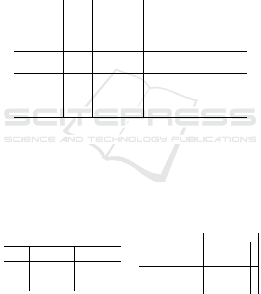
Table 1: Matrix Mangrove Suitability for Ecotourism.
Variables Weight
Highly Suitable
(S1) (score 3)
Moderate
Suitable(S2)
(score 2)
Marginally
Suitable (S3)
(score 1)
Mangrove
diversity
3 > 5 3-5 1-2
Mangrove
thickness (m)
3 > 500 > 200 – 500 50-200
Mangrove
density
3 >15-25 (100m²) >10-15 5-10
Range tide (m) 1 0-1 >1-2 > 2- 5
Freshwater
supply (Km)
1 < 1 1-2 > 2 Km
Accessibility 1 Good average bad
Slope 1
Nearly
level/Very
gently sloping
Steep Very steep
Source: Yulianda, 2007, with modification.
2.2. Suitability Analysis of Ecotourism
for Mangrove Forests on Tuada
Beach
Determination of the suitability of the mangrove
ecotourism class index can be determined based on
the assessment of the mangrove ecotourism
suitability matrix. Based on primary data and
secondary data, the land suitability class is obtained.
This suitability class was established based on
overlay variables thas has been weighted and scored,
thus defined by its class interval as can be seen in
table 2.
Table 2: Suitability Interval Based Category.
Class Category
Suitability
Interval
S1 highly suitable > 31
S2
Moderate
suitable
22-30
S3 not suitable 13-21
3 RESULT AND DISCUSSION
The results obtained from this research study were
presented in form of maps.
3.1 Mangrove Diversity
Mangrove diversity represents the variability of its
species of the area. Higher variability reflects its
potential for ecotourism.
Table 3: Mangrove composition on Tuada Beach, 2018.
No
.
Mangrove
Station
1 2 3 4 5
1. Rhizophora
mucronata L
+ + + + +
2. Bruguiera
g
ymnorrhiza
+ +
3. Ceriops tagal
(perr)
+
ICTL 2018 - The 1st International Conference on Teaching and Learning
224
4.
A
vicennia marina +
5. Rhizophora
apiculata BI
+ +
6 Avicennia
officinalis
+ +
7 Xylocarpus
g
ranatum
+ +
8 Xylocarpus
moluccensis
+ + +
9 N
y
pa
f
ruticans + + - - -
Total 6 6 3 3 3
Average 4,2 ~ 4 (S2)
(+) found
(-) not found
Based on table 3, it can be concluded that mangrove
of Tuada Beach consisted of 9 different species
which are Rhizophora mucronata L, Bruguiera
gymnorrhiza, Ceriops tagal (perr), Avicennia
marina, Rhizophora apiculata BI, Avicennia
officinalis, Xylocarpus granatum, Xylocarpus
moluccensis and Nypa fruticans. Mangrove in each
station could be different, RhizophorRga mucranata
L, Bruguiera gymnorrhiza, Ceriops tagal (perr),
Xylozarpus granatum and Xylozarpus moluccensi
and Nypa fruticans (1
st
station). Rhizophora
mucronata L, Bruguiera gymnorrhiza, Avicennia
marina, Rhizophora apiculata BI, Xylocarpus
moluccensis, and Nypa fruticans (2
nd
station),
Rhizophora mucronata L, Rhizophora apiculata BI
and Xylocarpus granatum (3
rd
station). Rhizophora
mucronata, Avicennia officinalis and Xylocarpus
moluccensis could be found in 4
th
station, while
Rhizophora mucronata L, and Avicennia officinalis
for the 5
th
station. In average there are 4,2 ~4
different species within the area so that concluded as
moderately suitable (S2) for ecotourism.
3.2 Density and Mangrove Thickness
The distribution of mangrove density in the study
area has a very rare, rare, medium and very dense in
density. Its density is considered not suitable (S3).
Mangrove thickness at I-V station has an average
mangrove thickness 550-600 m. The thickness at the
1
st
station to station 5 can be categorized moderately
suitable (S2) because it is in the value of more than
500 m.
3.3 Slope
The slope of the beach in Tuada village is
categorized as flat to almost flat with a value of ˂
3% so that was highly suitable for ecotourism (S1).
Flat slope and sloping is very suitable for bathing
and swimming activities (Purbani, 1999). A slope
can affect the safety of visitors when bathing and
swimming on the beach. Slope could also effect on
abrasion and a land subsidence, which makes the
soil unstable and change its location, thus affects the
saplings of mangroves that grow and expand along
the coast
3.4 Tidal Range
Based on tidal data from the results of the previous
research and tidal data from Dishidros AL (2009), it
is known that in Jailolo has the same type as other
area in the Halmahera island group, which has two
episodes of equal high water and two episodes of
low water each day (Semi-Diurnal Tide Type).
Data showed that tidal ranges generally range
from 3 to 1,7 meters that could cause more shallow
parts of the water to appear on the surface. The tidal
range concluded moderately suitable (S2) because of
its safety reason and its effects on the vertical
distribution of mangroves.
3.5 Freshwater Supply
The existing water resources in an area greatly
influences the economic activities of the population
in the region. The existence of clean water is very
influential in the development of tourism objects and
the surrounding area. In coastal tourism areas, the
availability of fresh water is the main object besides
sea water. Freshwater sources come from
underground springs and rivers that are adjacent to
tourist sites. The result showed that water resources
in Tuada beach for tourism activities came from
Todowongi River and resident wells within 0.1-0.67
Km perimeter. Based on the criteria in the land
suitability matrix, the availability of fresh water is
categorized as highly suitable (S1) because the
freshwater resource located was only < 0.5 km from
the area. With the presence of fresh water sources
that are close to the beach, this can support the
activities of visitors or tourists. The source of fresh
water is absolutely necessary, especially for the
survival of the population and supporting the
development of the potential for tourism in the area
of small islands (Dahuri, 2003). And when
conducting tourism activities, the availability of
clean water is very necessary to support
management facilities and tourism services
(Handayani, 2010).
Mangrove Suitability for Ecotourism Location in Tuada Village, Jailolo, West Halmahera
225
3.6 Accessibility
Accessibility is the the link between zones whose
forms are in the form of transport facilities in the
broadest sense, covering transportation networks,
such as: terminal capacity (airports, ports, and
stations), road networks, and service networks,
including: vehicle availability / transportation
(transportation modes), costs reasonable, and
reliable service. In addition, the frequency and speed
of service can result in long distances as if being
closer. Increased accessibility means shortening the
time and will certainly reduce costs.
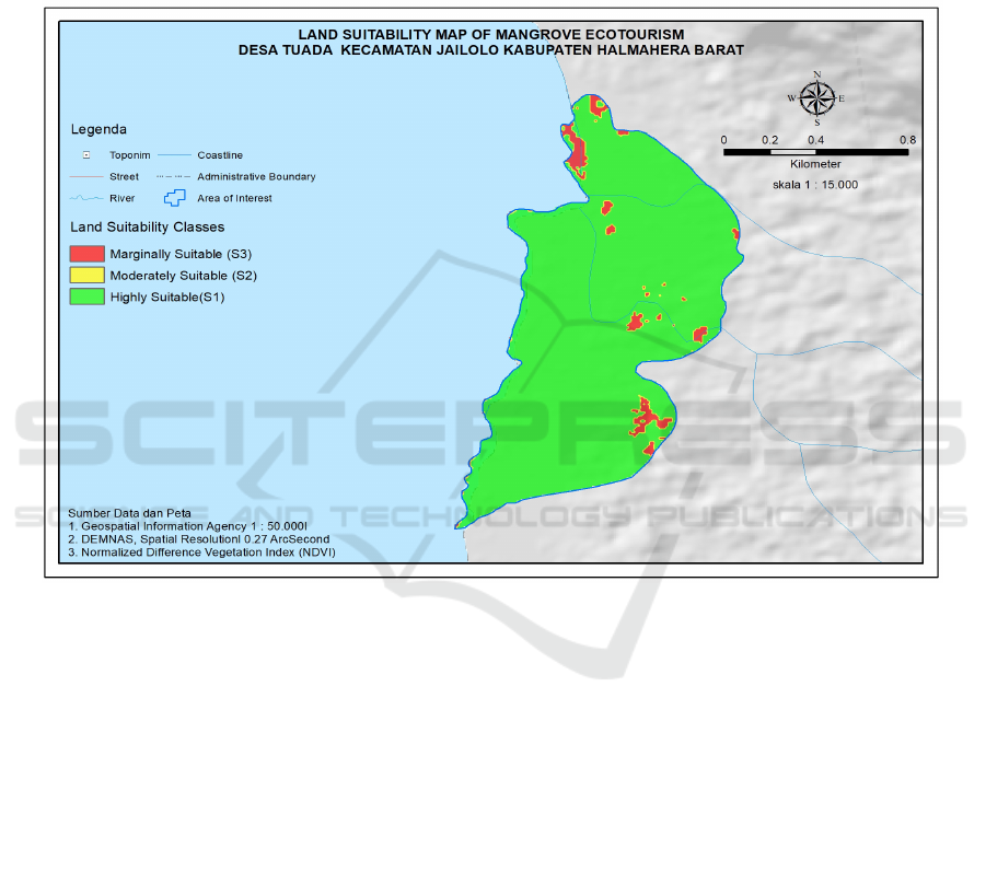
The land suitability class was obtained based on the
suitability interval. As could be seen that the Tuada
Beach categorized as highly suitable (S1) and
moderately suitable (S2).
Figure 1: Mangrove suitability map for ecotourism in Tuada Village, Jailolo, West Halmahera.
Results showed that mangrove thickness was
suitable. It has a flat slope, which very suitable for
ecotourism. Tidal range varies between 3-1.7 meters
which suitable for ecotourism, while water supply
located for 0.1 – 0.67 km from the area and it's
considered suitable for ecotourism. This area has
good accessibility. For the density of mangrove
varies between rare until very dense, while its
variety consists of 8 species.
4 CONCLUSION
Tuada Beach has the potential to be developed for
mangrove ecotourism, as its suitability varies from
suitable to highly suitable (S1). For its potential and
suitability, the facilities need to improve as this
beach recommended for ecotourism spot. Yet, in
some part of the area need cultivation, so that the
conservation of the mangrove could've sustainable.
ACKNOWLEDGEMENTS
The authors of this paper are thankful to Dr
Abdulrasyid Tolangara, M.Si for his support during
the research and PKUPT as the main support for the
funding.
REFERENCES
Dahuri, R., 2003. Keanekaragaman Hayati Laut;
Aset Pembangunan Berkelanjutan
ICTL 2018 - The 1st International Conference on Teaching and Learning
226

Indonesia. Jakarta : Gramedia Pustaka
Utama.
Dinas Hidro-Oseanografi TNI AL. 2009. Daftar
Tabel Pasang Surut (Tide-Tables)
Kepulauan Indonesia Tahun 2009. Jakarta:
Dinas Hidrologi dan Oceanografi, Tentara
Nasional Indonesia Angkatan Laut.
Dissayanake, N., and Chandrasekara., 2014. Effects
of Mangrove Zonation and the Physicochemical
Parameters of Soil on the Distribution of
Macrobenthic Fauna in Kadolkele Mangrove
Forest, a Tropical Mangrove Forest in Sri Lanka.
Advances in Ecology. Vol 2014; 1-13.
Handayani, 2010. Kajian Sumberdaya Pesisir Untuk
Pengembangan Wisata Pantai Cexorok Painan,
Kabupaten Pesisir Selatan Sumatra Barat
(Skripsi).
Lee, S. Y., et.al. 2014. Ecological Role and Services
of Tropical Mangrove Ecosystems:
Reassessment. Global Ecology and
Biogeography. 23, 726-743.
Purbani, D., 1999. Aplikasi Geografi Fisik Indonesia
Kawasan Wisata Pesisir di Pulau Lombok.
Jakarta : Pasca Sarjana Ilmu Geografi UI.
Sirajudin, N., Mas’ud, A., dan Sundari. 2018. A
study of the mangrove community in the coastal
area of Dodinga Bay, South Jailolo District,
West Halmahera Regency, North Maluku
Province. International Conference on Global
Resource Conservation (ICGRC) and AJI from
Ritsumeikan University AIP.pp, 1-3.
Yulianda, F., 2007. Ekowisata Bahari sebagai
Alternatif
Pemanfaatan
Sumberdaya Pesisir
Berbasis Konservasi. Presented at Sains
Seminar February 21
st
2007.
Bogor:
MSP
Department. FPIK. IPB.
Mangrove Suitability for Ecotourism Location in Tuada Village, Jailolo, West Halmahera
227
