
Assessing the Potential of Tambakboyo Retention Basin for Raw Water
Supply in the City of Yogyakarta Indonesia
Edy Sriyono
1
, Agung Purwanto
1
, Sardi
1
, Nindyo Cahyo Kresnanto
1
, Tania Edna Bhakty
1
and
Muhammad Kunta Biddinika
1
1
Civil Engineering Master’s Degree Program, Janabadra University, Jalan Tentara Rakyat Mataram 55-57 Yogyakarta,
Keywords:
Water resources, retention basin, water potential.
Abstract:
This paper presents an assessment of the potential of Tambakboyo basin as one of the potential new water
sources due to the water shortage in some areas of the city of Yogyakarta. It is a retention basin located in the
Sleman Regency, Special Province of Yogyakarta, Indonesia. The basin has overflow elevation of +147,00 m
and retrieval pipe elevation of +141,00 m. This assessment includes an analysis of the inflow, rain fall on the
surface of the reservoir, outflow for water requirements, water loss from evaporation and seepage. By using
the scales of water balance and simulation of water retrieval, we are able to determine water potential of the
basin for clean water.
1 INTRODUCTION
Some areas in Yogyakarta City have experienced wa-
ter crisis. The region consists of 5 (five) subdis-
tricts, namely District Gondokusuman, Mergangsan,
Mantrijeron, Jetis and Umbulharjo. To overcome the
problem, water sources that can be utilized for water
daily usage should be reduced.
The increasing demand for water causes some
areas in Yogyakarta to experience water shortages.
These short comings can be met by utilizing the po-
tential of existing water resources. In Kabupaten Sle-
man there is a potential source of water that is likely
to be used to meet water shortages. The source is Em-
bung Tambakboyo which until now has not been uti-
lized up to its potential. In addition to the overflow,
the embung location is also higher than areas that re-
quire water, making it possible to stream the water
using gravity.
Embung Tambakboyo is one of water retention
basin that was built from 2003 until 2008 in Tambak-
boyo River upstream or in the meeting between Klan-
duan River and the downstream of Sembung River.
The embung location is in Condongcatur Village, De-
pok District, Sleman Regency, Special Region of Yo-
gyakarta. According to the interviews with local resi-
dents around the embung, in the dry season Tambak-
boyo Embung pond is always fully charged and water
always overflowed through the spillway. The condi-
tion gives an illustration that Embung Tambakboyo
has water potential that can be utilized for raw water
usage (Pengairan, 1986) (Kamiana, 2011).
For that we need a study of how much potential
water Embung Tambakboyo can be utilized to meet
the lack of water in the city of Yogyakarta. The study
will be conducted by simulating water retrieval based
on the water balance of embung which is the relation-
ship between inflow, outflow and the number of con-
tainers (Gustian, 2014).
2 LITERATURE REVIEW
2.1 Water Resources Development
According to (Triatmodjo and Terapan, 2008), water
resources development can be grouped into two activ-
ities, namely water utilization and water management
(Figure 1). Water utilization activities include the pro-
vision of water for irrigation water needs,households,
offices, hospitals, education, houses of worship, ho-
tels, river maintenance/raiding, fisheries, livestock,
industry and so on. These various needs can be served
by available water which can be either surface water
or ground water with certain reliability. Water reg-
ulation activities include flood control, drainage and
waste management. These activities are conducted to
96
Sriyono, E., Purwanto, A., Sardi, ., Kresnanto, N., Bhakty, T. and Biddinika, M.
Assessing the Potential of Tambakboyo Retention Basin for RawWater Supply in the City of Yogyakarta Indonesia.
DOI: 10.5220/0009878900960100
In Proceedings of the 2nd International Conference on Applied Science, Engineering and Social Sciences (ICASESS 2019), pages 96-100
ISBN: 978-989-758-452-7
Copyright
c
2020 by SCITEPRESS – Science and Technology Publications, Lda. All rights reserved
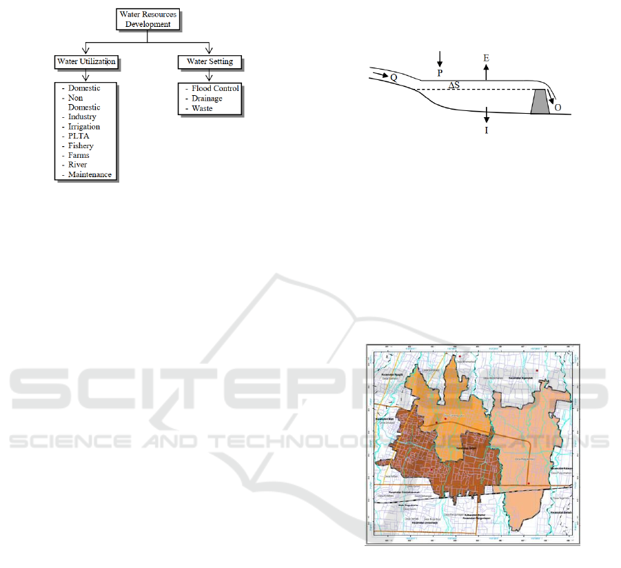
overcome the existence of excessive water in the form
of floods that can cause harm to the community.
Figure 1: Water Resources Development Activities.
The relationship between the two activities is in
the rainy season the water will be abundant so that
should be thrown into the sea so as not to cause
flood. But in the dry season the availability of wa-
ter is significantly reduced, making itdifficult to meet
the needs of water that is relatively fixed and even in-
creases along with the increase of population. To that
end, it takes facilities such as embung to accommo-
date excess water in the rainy season and use it in the
dry season.
Water utilization includes the study of water avail-
ability and water requirements as well as planning fa-
cilities/buildings that can meet these needs from avail-
able water availability. For that we need to know the
amount of water available and the current water needs
and predictions of future needs. From both analy-
sis, we can calculate water balance in a watershed,
by comparing the availability and the need for water.
2.2 Water Balance
Embung is a water retention structure that serves to
store water while at the time of excess water and
released in the event of water shortage. The wa-
ter balance of the embung is based on the continu-
ity equation which is the relationship between in-
let water, outlet water and the number of contain-
ers. Figure 2 shows the water balance in the embung,
which can be mathematically expressed in terms of
the following equation (Asdak, 2018), (Brotowiry-
atmo, 1993)(Hadisusanto, 2010):
Q + P = O + E + I + ∆S (1)
where Q is inlow from the river, rainfall that falls
on the surface of the reservoir, O is outflow for irri-
gation water needs; raw water and so on, E is evapo-
rated, I is water loss from seepage, and ∆S is the water
reservoir in the reservoir.
Figure 2: Embung’s water balance.
3 METHODOLOGY
3.1 Location
The research was conducted at Embung Tambakboyo
in Tambak Bayan River, Condongcatur Village, De-
pok District, Sleman Regency, Yogyakarta Special
Region as presented in Figure 3.
Figure 3: The location of Embung Tambakboyo.
3.2 Inflow
The inflow water discharges consists of the flow of
streams and rain falling on the surface of the embung.
River flow discharge in question is the result of Mock
simulation that has been calibrated with debit data .
While the rain falling on the surface of the embung
multiplied by the surface area of the embung.
3.3 Outflow
The outflow water discharges consist of water require-
ments for various purposes (water requirements for
irrigation and fisheries), and water loss from evapora-
tion and seepage.
Assessing the Potential of Tambakboyo Retention Basin for RawWater Supply in the City of Yogyakarta Indonesia
97
3.4 Water Balance Simulation of Water
Retrieval
The availability of Tambakboyo water pond comes
from the inflow and outflow. Analysis of water avail-
ability is estimated based on the water balance of the
reservoir calculated using equation (1), then the simu-
lation of water harvesting was conducted to determine
the maximum limit of water retention ponds.
4 RESULT AND DISCUSSION
4.1 Inflow
The inflow of Embung Tambakboyo consists of 90%
(Q90) mainstay discharge of Mock simulation result
and 90% rainfall (R90) result of area rainfall analy-
sis multiplied by embung pond area of 60,542.4 m2
as presented in Figure 4. The table shows that the
largest inflow was in February, which was 1989.29
lt/sec while the smallest inflow was in December,
which was 36.12 lt/sec.
Figure 4: Inflow (Q + P).
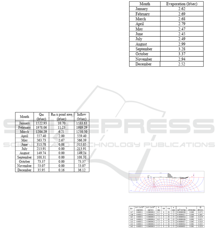
4.2 Water Loss due to Evaporation
Water loss due to evaporation above the water sur-
face of the embung is calculated from the evapora-
tion value of modified Penman method multiplied by
the surface area of the pond. In full conditions, the
water level elevation is at + 147.00 m elevation with
a surface area of 60,542.4 m2. The results of Em-
bung Tambakboyo evaporation calculations are pre-
sented in Figure 5.
The table shows that the largest water loss due
to evaporation was in October, which was 3.37 lt/sec
while the smallest water loss due to evaporation was
in July, which was 2.49 lt/sec.
Figure 5: The evaporation of Embung Tambakboyo.
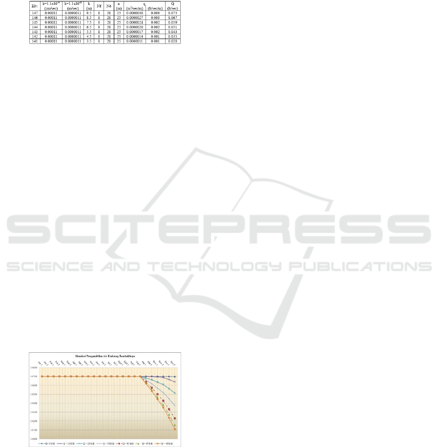
4.3 Water Loss from Seepage (I)
The flow-net projection (Hardiyatmo, 2012), result-
ing in 8 (eight) flow lines (Nf) and 30 (thirty) equipo-
tential lines (Nd). If the water level is at + 147.00
m elevation, there is a high energy difference (h) be-
tween the beginning and end (9,89 m) equipotential
energy line (Nd). From the depiction presented in
Figure 6, water loss from seepage that occurred in
Embung Tambakboyo is 0.073 lt/sec, the full calcu-
lation is presented in Figure 7. The table shows that
the largest water loss from seepage (I) is at + 147.00
m elevation, which was 0.075 lt/sec while the smallest
water loss from seepage (I) is at + 141.00 m elevation,
which was 0.028 lt/sec.
Figure 6: Flownet of Embung Tambakboyo.
Figure 7: Calculating the seepage of Embung Tambakboyo.
4.4 Water Balance and Simulation of
Water Retrieval
The water scale of Embung Tambakboyo Watershed
is the ratio between the inflow and the outflow. The
difference from the comparison provides information
ICASESS 2019 - International Conference on Applied Science, Engineering and Social Science
98
on water availability from January to December. In
the case of a water surplus (+) or water deficit (-
), the pond retention pond remains fully charged at
387,947.47 m3 at +147.00 m elevation. The water
balance of the Tambakboyo Embung Watershed is
presented in Figure 8.
Figure 8: Water balance of Embung Tambakboyo.
In the case of surplus water (excess water), the ful-
fillment of water needs for various purposes (outflow)
using the inflow of water (inflow). If there is still any
residual from the inflow, the water is considered to be
melted.
In the state of water deficit (lack of water), the ful-
fillment of water needs for various purposes (outflow)
using water reservoir embung. This situation resulted
in decreasing embung volume and decreasing of sur-
face water level. Change of embung water storage is
calculated based on water balance of embung.
In Embung Tambakboyo at the rear of the drain
door, there is a 16-inch galvanized tube at + 141.00 m
elevation. The pipe is fitted with the purpose can be
utilized if there is a plan of utilization of Tambakboyo
water pond for raw water.
Based on the water balance of the embung, the
volume of the containment and the presence of the
pipe, a simulation of water harvesting to determine
the maximum limit of water retention ponds from el-
evation +147,00 m to elevation + 141,00 m. The sim-
ulation uses alternate picking, 10 lt/sec, 20 lt/sec, 30
lt/sec, 40 lt/sec, 45 lt/sec and 48 lt/sec. The calcula-
tion of the complete water-taking simulation is pre-
sented in Figure 9.
Figure 9: Graphical simulations of water retrieval at Em-
bung Tambakboyo.
Figure 9 provides information on the influence of
each of the water-taking alternatives. The information
will be explained as follows:
1. Take water of discharge 0 lt/sec The utilization of
the catchment water occurred in December when
Embung Tambakboyo was ina state of water de-
viation. When uses 0 liters/second of water re-
trieval, leaving a volume of 385,928.30 m3 of
contained water at an elevation of + 146.97 m.
2. Take water of discharge 10 lt/sec The utilization
of shelter water occurs from November to Decem-
ber at the time of Embung Tambakboyo in a state
of water deviation. When a 10 liters/second water
discharge is used, it will leave the volume of wa-
ter in the reservoir 352,676.69 m3 at elevation +
146.41 m.
3. Take water of discharge 20 lt/sec The utilization
of shelter water occurs from October to December
when Embung Tambakboyo is in a state of water
deviation. When a 20 liters/second liquefaction
discharge is used, it will leave a water volume in
the reservoir of 278,698.03 m3 at an elevation of
+ 145.15 m.
4. Take water of discharge 30 lt/sec The utilization
of shelter water occurs from October to December
when Embung Tambakboyo is in a state of water
devisit. When a 30 liters/second water discharge
is used, the volume of water in the container will
be 199.210.03 m3 at elevation + 143,74 m.
5. Take water of discharge 40 lt/sec The utilization
of shelter water occurs from October to Decem-
ber when Embung Tambakboyo is in a state of
water deviation. When a 40 liters/second water
discharge is used, it will leave a water volume in
container of 119.722.03 m3 at elevation + 142.31
m.
6. Take water of discharge 45 lt/sec The utilization
of shelter water occurs from October to Decem-
ber when Embung Tambakboyo is in a state of
water deviation. When a 45 lt/sec water discharge
is used, it will leave a volume of 79,978.03 m3 of
water in storage at + 141.54 m elevation.
7. Take water of discharge 48 lt/sec The utilization
of shelter water occurs from October to December
when Embung Tambakboyo is in a state of water
deviation. When a water harvesting rate of 48 lt/dt
is used, it will leave a volume of water in the reser-
voir of 56,131.63 m3 at elevation + 141.09 m.
5 CONCLUSIONS
1. Embung Tambakboyo is a very strategic water
source that can be used to help overcome the lack
of water in some areas in Yogyakarta city. This is
because the location is higher than the area in the
city of Yogyakarta that requires the water.
Assessing the Potential of Tambakboyo Retention Basin for RawWater Supply in the City of Yogyakarta Indonesia
99

2. By utilizing the volume of the embung em-
bankment to reach the dead storage elevation
(+141.00), then dry season with 90% reliability,
the water in Tambakboyo embung can be col-
lected by 48 lt/sec without disrupting the utiliza-
tion of exsisting water, such as for Irrigation and
fish ponds.
REFERENCES
Asdak, C. (2018). Hidrologi dan pengelolaan daerah aliran
sungai. Gadjah Mada University Press.
Brotowiryatmo, S. (1993). Analisis hidrologi.
Gustian, M. (2014). Optimasi parameter model dr. mock
untuk pengelolaan daerah aliran sungai. ETD Un-
syiah.
Hadisusanto, N. (2010). Aplikasi hidrologi, jogja mediau-
tama.
Hardiyatmo, H. (2012). Mekanika tanah i.
Kamiana, I. M. (2011). Teknik perhitungan debit rencana
bangunan air. Graha Ilmu, Yogyakarta.
Pengairan, D. P. U. (1986). Standar perencanaan irigasi kp–
01. Bandung: CV Galang Persada.
Triatmodjo, B. and Terapan, H. (2008). Beta offset.
ICASESS 2019 - International Conference on Applied Science, Engineering and Social Science
100
