
Analysis of Cartographic Generalization based on PYTHON
Programming Language on Digital Topographic Maps
Marko Stojanović
1
, Siniša Drobnjak
1a
, Jasmina M. Jovanović
2
, Nenad Galjak
3
and Ana Vučićević
4
1
Military Geographical Institute, Mije Kovačevića 5, Belgrade, Serbia
2
Faculty of Geography, University of Belgrade, Studentski trg 3/3, Belgrade, Serbia
3
Military Academy, University of Defense, Pavla Jurišića Šturma 33, Belgrade, Serbia
4
PE “Roads of Serbia”, Brodarska bb, Belgrade, Serbia
vucicevic.ana@outlook.com
Keywords: GIS, Automatic Cartographic Generalization, Digital Topographic Maps, Geospatial Database, PYTHON.
Abstract: Cartographic generalization is a creative process of abstraction, which is used in the design and content
preparation of topographic maps. It includes the study of the geographic environment, processing of
geographic data, and an evaluation with regard to type, purpose, and scale of the map, or selecting and
merging their graphical presentation, with a big or small degree of abstraction. In the era of digital
cartography more attention is paid to developing tools for automatic generalization of cartographic content.
In this paper, automatic cartographic generalization is analyzed based on PYTHON programming language
for production of digital topographic map scale 1:50 000 (DTM50) from digital topographic map scale 1:25
000 (DTM25).
a
https://orcid.org/0000-0001-6566-5538
1 INTRODUCTION
Cartographic generalization is generally performed
based on previously developed criteria. These
criteria are formed upon maps development on the
basis of tests before making the map and in the
course of preparation, they do not change. It is a
requirement that the map has uniformed values and
standard quality throughout the territory being
mapped. The need for a broader range of all of the
map, not only in its size and content but also the
form and manner of presentation, cartographer is
bound to seek and find real special cartographic
generalizing criteria for each map. Success in this is
one of the key factors to create good and meaningful
maps.
The research of automatic map generalization
can be connected to different platforms for
development. Automatic cartographic generalization
is the process on which many studies are focused.
The main task of mapping and the generalization
process is to solve the problem of expressing the
core, typical and characteristic features of the
mapping territory and the occurrence of it in
accordance with the purpose and scale of the map.
From a large number of geographic data that exist on
the mapping territory a logical amount of data
should be drawn, which are of general interest and
can be clearly shown on maps. Data selection is the
result of a need for analysis with regard to the
purpose of the map, the opportunities provided by a
map scale and a geographic result of a study of the
situation on the ground. (Burghardt et al., 2008;
Kazemi et al, 2007; Lamy et al., 1999; Lee & Hardy,
2005; Regnauld, 2005).
Following the development of standards in the
field of collection, organization, processing, and
presentation of spatial data in the Military
Geographical Institute (MGI) - Belgrade, spatial data
of digital topographic maps at the scale 1:25 000
(DTM25) are organized in the Central Geospatial
Database at the scale 1:25 000 (GSD25). It is used to
generate other scale-based series maps produced in
MGI, digital topographic maps in the scale of 1:50
000 (DTM50), 1:100 000 (DTM100) and 1:250 000
(DTM250) (Drobnjak et al, 2016; Tatomirović,
2017).
Stojanovi
´
c, M., Drobnjak, S., Jovanovi
´
c, J., Galjak, N. and Vu
ˇ
ci
´
cevi
´
c, A.
Analysis of Cartographic Generalization based on PYTHON Programming Language on Digital Topographic Maps.
DOI: 10.5220/0009396501910198
In Proceedings of the 6th International Conference on Geographical Information Systems Theory, Applications and Management (GISTAM 2020), pages 191-198
ISBN: 978-989-758-425-1
Copyright
c
2020 by SCITEPRESS – Science and Technology Publications, Lda. All rights reserved
191
2 GEOSPATIAL DATABASE AT
SCALE 1:25 000 (GSD25)
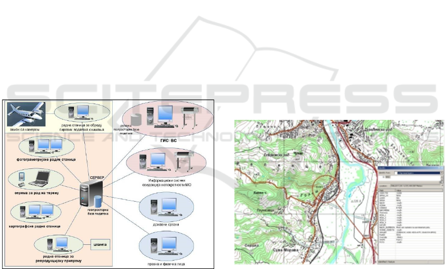
The technological process of production spatial data
for GSD25 is introduced into the technology of
digital photogrammetric restitution, as well as global
positioning technology (GPS) to support the GSD25
update on the ground. Applicability of GSD25 made
this particularly important aspect of the whole
production of different scale series topographic
maps with cartographic generalization tools,
cartographic reviewer and support in printing
topographic map sheets.
The technological process of GSD25 is based on
mapping methods, map content and digital
photogrammetric restitution cartographic, processing
it into a GIS environment, using reference
alphanumeric data. The vectorization process is
implemented in strict compliance with the logical
data model respecting the possibility, or mode of the
selected software environment. Anticipated
technological solutions making GSD25 imply that
the content and update methods also perform digital
photogrammetric restitution. The whole
technological process of developing the capabilities
of GSD25 data distribution is shown in Figure 1.
Figure 1: The technological process of GSD25.
To create GSD25 software, U.S. Company ESRI,
ArcGIS platform was chosen, which contains a
completely new approach to the formulation of
geospatial databases. The software platform
selection has caused the brand new technology in all
phases of the work, but they retained the existing
mapping solution. Given these requirements, the
development process includes the following phases
GSD25 work (Sekulović & Drobnjak, 2011):
Making a logical data model;
Creating a model for generalization;
Making a physical data model;
Creating symbology;
Making a logical model of the process;
Making a physical model of the process;
Creation of procedures for generalizing and
Training.
In the process of developing the logical data
model DTM25, the geographical map elements are
differentiated by the thematic groups. Individual
cases each of system elements are defined by layer
and codes as a unique indicator of belonging to the
appropriate thematic group (Marković, 2009).
The physical data model is defined by the
appearance of a database or “space” to store
elements defined by tasks' logical model. Data types,
method of data storage as well as all columns that
are used for input attributes of object classes and
individual objects are also defined in the design of
the physical data model. Defining the visual
appearance GSD25 physical data modelling in
which will be used in the interface software
determines the order of topics and, further defines
the visual display of GSD25, a level that cannot be
achieved through symbolism. This phase is the last
step in the development of GSD25 in terms of
practical preparation. Figure 2 shows the
visualization of complete produced part of GSD25.
Figure 2: Visualization of complete produced part of
GSD25.
The entire process of making GSD25 was
conducted by relying on the ArcGIS environment,
and the available hardware resources in the MGI-
networked. This resulted in the division of
responsibilities in working with spatial data,
establishing a system of accountability in the process
of sharing and flow of information in the network,
and data archiving. During the whole process of
making GSD25, special attention was paid to the
GISTAM 2020 - 6th International Conference on Geographical Information Systems Theory, Applications and Management
192
backup data and monitoring the implementation of
the entire task in map sheets and operators
(Sekulović & Drobnjak, 2011).
3 AUTOMATIC
CARTOGRAPHIC
GENERALIZATION
The automation of cartographic generalization
processes in the digital environment is increasingly
evolving, with the aim of obtaining accurate and up-
to-date spatial information through high-quality
cartographic representations. Automatic generaliza-
tion procedures are sets of algorithms that can be
modified by parameters, depending on purpose,
theme, and scale of the map. Automatic
generalization should make possibility to obtain
accurate choice as much possible as of the original
data from the same database to different map details.
The complexity of automatic generalization is
determined by the selection of criteria that influence
the choice of object type according to its importance
for display. The generalization system involves a
generalization of the original spatial database, taking
into account the different attributes of spatial data, as
well as adequate graphical solutions when
presenting a generalizable dataset (Jovanović, 2017).
The goal of automation in cartographic
generalization is to perform the steps by software in
map-making process. In addition to speeding up
work, automation avoids repetitive actions that do
not require human decision-making or can be
formulated. It eliminates the possibility of errors that
may occur and optimizes map-making process. The
problem is defining rules by which generalization
would be done and organizing them into a single
system. To translate all the knowledge and
experience, rules and techniques from classical
cartography, in order for a computer to simulate
human decisions is a difficult task and a special
challenge. The operations performed should be as
close as possible to what a person would perform in
each case.
One of the main problems in automation are
steps in execution order, which are interdependent.
All cartographic generalization procedures should be
viewed as a unique process, not as a series of
isolated independent procedures. The displacement
of one content element often results in the
displacement or elimination of another, and it may
be that other elements must neither be eliminated
nor displaced. To reduce complexity, the entire
process is often subdivided into individual
subprocesses (João & Elsa, 1998).
3.1 Mapping Generalization
Subprocesses
The mapping generalization subprocesses perform
some action on map elements. Each subprocess
defines a transformation that can be applied to one
or a group of spatial objects. Some are for one type
of data only (point, line or polygon) and some for
two or more. Despite the frequent use of
subprocesses worldwide, there is no general
agreement on either the number or the terminology
used to describe these subprocesses. Although there
are several classifications with different numbers of
mapping generalization subprocesses, the ones that
stand out to Lee are the following.
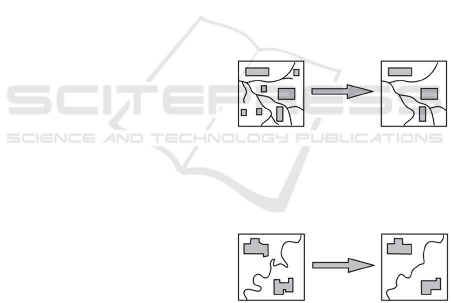
Elimination - This subprocess rejects different
geographic objects because of their small size or less
importance in relation to the map purpose (eg.
elimination of small islands, elimination of short
streets).
Figure 3: Subprocess Elimination (Lee, 1996).
Simplification - This subprocess is the selective
exclusion, rejection, elimination, omission of single
point or groups of points that make up an object.
Parts of the building are discarded in order to
simplify its appearance, but with the preservation of
key parts, in order to maintain recognition.
Figure 4: Subprocess Simplification (Lee, 1996).
Aggregation - By grouping groups of identical
or similar and territorially close objects that do not
touch each other, one object is displayed that
represents them all. It is possible to present a group
of points with polygons related to the surface on
which they are located (eg. merging of small nearby
lakes into one larger lake).
Analysis of Cartographic Generalization based on PYTHON Programming Language on Digital Topographic Maps
193
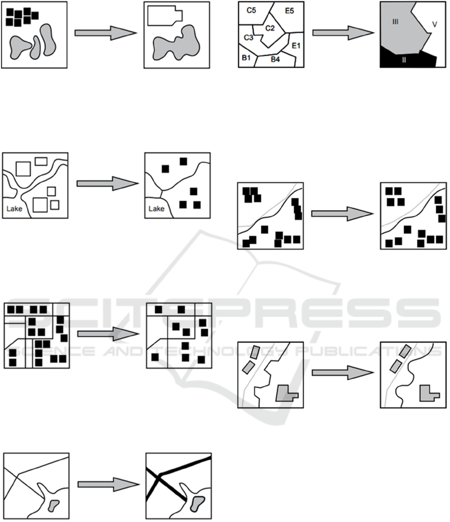
Figure 5: Subprocess Aggregation (Lee, 1996).
Size reduction - This subprocess reduces the
size of a particular geographic object or stack of a
group of parallel or near-parallel lines to a smaller
number of lines.
Figure 6: Subprocess Size reduction (Lee, 1996).
Typification - This subprocess reduces the
density of spatial objects as well as the level of
detail while maintaining a representative distribution
pattern of these objects.
Figure 7: Subprocess Typification (Lee, 1996).
Exaggeration - This subprocess increases the
spatial extension of the geometric representation of a
given object, to focus on its significance and
improve readability.
Figure 8: Subprocess Exaggeration (Lee, 1996).
Classification and Symbolization - This
subprocess combines elements that share similar
geographical attributes into a new object, which in
turn has a higher degree of abstraction, in addition to
the new symbol.
Figure 9: Subprocess Classification and Symbolization
(Lee, 1996).
Displacement - This subprocess is used to
resolve conflicts, that is, used to move an object on
the map if it overlaps with another occurrence or is
too close to it. When moving, the object retains its
shape. This is the most complicated generalization
operator since it requires complex measurements.
Figure 10: Subprocess Displacement (Lee, 1996).
Refinement - This subprocess changes and
adjusts the geometry or appearance of an object to
enhance the aesthetic (visual) aspect while ensuring
its similarity to reality (eg. "smoothing" a line,
modifying the orientation of some symbols).
Figure 11: Subprocess Refinement (Lee, 1996).
3.2 Defining the Automatic Map
Generalization Model
The model of cartographic generalization includes
generalization of the entire content of digital
topographic maps, which essentially can be graphic
and conceptual. Processes related to the graphic
generalization mainly deal with the geometric
component of spatial data so that they can be
automated. Opposed to them, the processes of
conceptual generalization mainly affect component
characteristics that occur, and those are harder to
automate. The problem of automated generalization
of geographical names is even greater due to fact
that processes contain both types of generalization.
(Stoter et al, 2009). This problem is solved by
GISTAM 2020 - 6th International Conference on Geographical Information Systems Theory, Applications and Management
194
additional processing in preparation for printing.
Some subprocesses are present in both
conceptual and graphic generalization, but there are
differences in the causes of their application.
Subprocesses performing graphic generalization are
interdependent and cannot be viewed separately
from other content on the map. Some activities
require concurrent compliance with the resulting
changes resulting from their implementation. For
example, polygons representing a class and being
displaced should merge with polygons of the same
class as soon as they come into contact. Such
simultaneous execution of activities can be upgraded
by dividing the whole process into stages. This
would lead to the activation of a predetermined
subprocess after each phase, which would be
executed if the given condition is fulfilled. For
example, each time after moving polygons for a
certain distance, if they are in contact with polygons
of the same class, the displaced polygons merge with
them. After that comes the second step in which the
others move further and it is checked again that now
these displaced polygons are in contact with
polygons of the same class. Another factor that can
influence the outcome of cartographic generalization
is the order in which subprocesses will be used.
Proper selection of the execution order can influence
the final appearance of the map. Also, there are a
number of different algorithms for each subprocess.
Not all subprocesses are equally represented in the
generalization process. Sublimation of two or more
operators placed in a proper arrangement is a model
of cartographic generalization (Stojanović, 2018).
It is possible to automate those forms of
generalization that can be numerically interpreted
and expressed in mathematical form, as well as those
that necessarily generalize the classifications of
mapped objects by creating models of cartographic
generalization. It is easy to automatically reduce
objects smaller than the established census or to
select objects determined by normative indicators. In
doing so, a set of choice indicators can be used on
the computer at the same time, taking into account
the correlation of an occurrence with other objects, if
it can be expressed in mathematical form (eg. by
setting a minimum distance between adjacent
objects at the expense of reducing less significant
ones) and may change the value indicators in
different regions. The census approach can also be
applied to geometric side of generalization in terms
of automatic contours generalization or other lines,
e.g. automatically reduce curves and fractures on
lines smaller than a given size (Drobnjak, 2016).
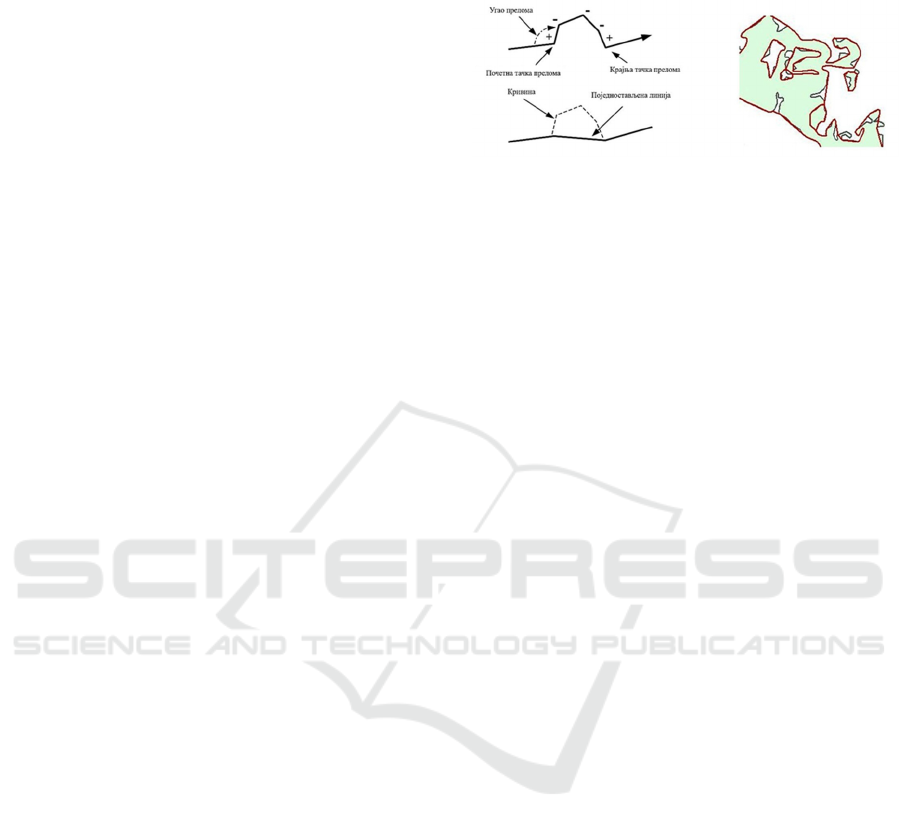
Figure 12 shows an example of automatic curvature
reduction in detail and on an entire object using the
Simplification subprocess.
Figure 12: Automatic curve reduction using simplification
subprocesses, detail view (left) and entire object (right)
(Lee & Hardy, 2005).
3.3 Requirements and Limitations for
Cartographic Generalization
Cartographic generalization is a complex process
because of subjectivity and lack of well-defined
rules in decision making processes necessary to
compensate visual problems. During this demanding
process, it is important to understand why, when,
and how to generalize, in order to select and apply
relevant subprocess to spatial objects (McMaster &
Shea, 1992).
The relevance of the generalization subprocess
depends on the particular design specifications to
which the solution applies. These specifications are
limitations that cartographers have to deal with. The
restrictions apply to the accuracy, scale, and purpose
of the map required, as well as to your visualization
medium (Stoter et al., 2008). For example, when a
tourist map is generated, priority is given to
semantic content elements that represent objects of
tourist interest in a picturesque way. This type of
object does not require the use of complex
subprocesses that offer high geometric accuracy. On
the other hand, such subprocesses may be required
when a map is generated for cadastral or military
use. Moreover, constraints also apply to handle,
readability of spatial objects (visibility threshold),
forms, spatial relationships (positioning of objects
relative to each other), and semantics. Considering
the fact that it is difficult, even impossible, to
overcome all limitations during cartographic
generalization, it is important to identify those that
are prioritized in relation to the purpose and scale of
the map (Plazanet et al, 1998).
For successful cartographic generalization, the
choice of the relevant subprocesses, as well as their
interlocation, are important. The same subprocess
will depend on where it is executed, generalize
different content in different ways. Also, a particular
subprocess may resolve a conflict that may re-occur
Analysis of Cartographic Generalization based on PYTHON Programming Language on Digital Topographic Maps
195
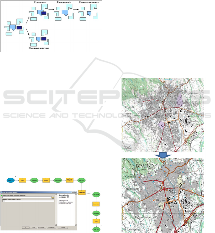
after the execution of other subprocesses. Figure 13
shows the impact of selecting the relevant subprocess,
set in the right place, on cartographic generalization.
The upper part of the picture shows how inadequate
selection of a subprocess can create new conflicts, and
thus necessitates new subprocesses, while the lower
part shows how the correct choice of subprocess
simply ie. with fewer steps, a quality can resolve a
particular conflict (Stojanović, 2018).
Figure 13: Impact of subprocess selection on
generalization results (http://downloads.esri.com).
4 ANALYSIS OF AUTOMATIC
CARTOGRAPHY
GENERALIZATION USING
PYTHON PROGRAMMING
LANGUAGE
Automatic methods of cartographic generalization of
spatial data that are the content of the GSD25 are
additionally programmed using the Python
programming language. Using ArcGIS software
applications based on the development of automated
tools using Model Builder, and their conversion to
Python scripts are very useful tools. These tools are
used for automatic conversion of content GSD25 to
spatial data of digital topographic maps of smaller
scales, primarily DTM50 (Figure 14).
Figure 14: Example of tools for cartographic
generalization of contour lines.
Different aspects of cartographic generalization
can be automated by creating a generalization
model, both numeric interpreted and expressed in
mathematical form as well as those which generally
classify mapped objects. Thus, for example simply is
automatically reduced by objects whose size is less
than the established threshold or select specific
objects normative indicators. In doing so, the
computer can simultaneously exploit a number of
indicators of choice and to take into account the
connection of phenomena with other phenomena, if
it can be expressed in mathematical form (eg.
providing the minimum distances between adjacent
buildings at the expense of reduction of less
important), and finally, it can change the value of the
indicator in different regions. A census approach can
also be applied to geometric side of generalization.
For example, automatically reduce lines curve and
fractures less than some specified size. In modern
software, there are options that support reduction of
curvature on the lines. For example, within the
ArcGIS software, there is an option Smooth Lines
performing this procedure.
Figure 15: Example of urban area generalization in
switching DTM25 (above) to DTM50 (below).
GISTAM 2020 - 6th International Conference on Geographical Information Systems Theory, Applications and Management
196
The main source for the cartographic
generalization was DTM25 with predefined model
data in a central database. The use of different, pre-
defined tools and generating new and using Model
Builder gave a very powerful tool for automated
map generalization, which enabled the creation of a
new, generalized DTM50.
The highest degree of generalization was defined
by using thematic areas of populated places, where
individual objects are grouped into two different
sections, the city property, and settlement blocks.
Objects of public interest are exempt from this kind
of generalization so that they are a simple
generalization of selection and reduction of
geographic content (Figure 15).
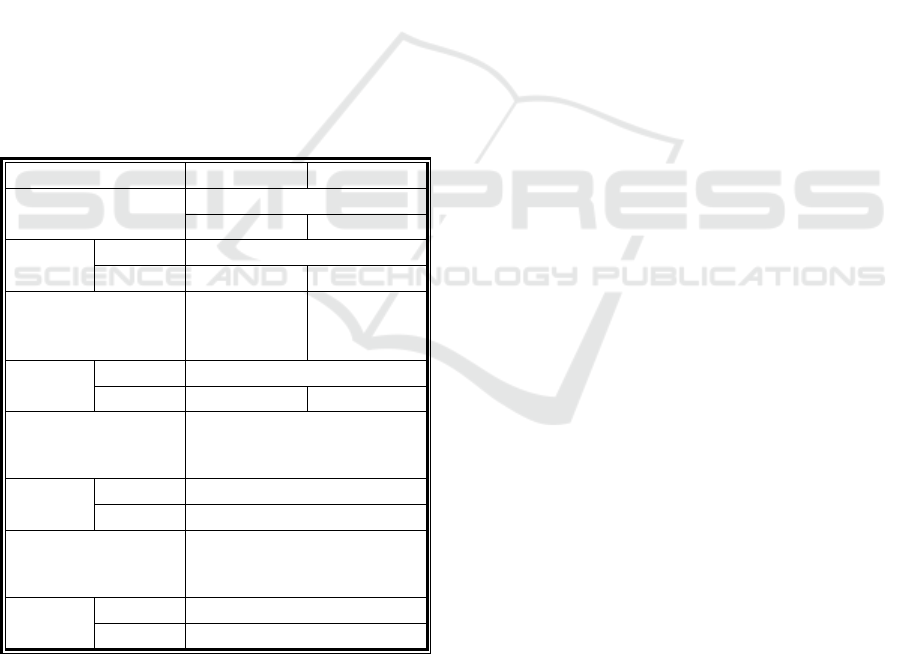
Table 1 shows a portion of cartographic
generalization model for thematic layer “Stagnant
water 3” which is the content of the GSD25 and
represents a conceptual generalization which define
certain limitations and conditions for transfer from
topographic map, scale 1:25 000 topographic maps
at the scale of 1:50 000 1: 100 000 and 1: 250 000.
Table 1: A portion of cartographic generalization model
for thematic layer “Stagnant water 3”.
Number 246 247
Name of the symbol
A lake
smaller bigger
DTM25
LAYER
46
SIFRA
461 462
Generalization
condition
DТM25>DТM50
An area
greater than
5.000 m
2
An area
greater than
10.000 m
2
DTM50
LAYER
46
SIFRA
461 462
Generalization
condition
DТM50>DТM100
An area greater than
20.000 m
2
DTM100
LAYER
46
SIFRA
461
Generalization
condition
DТM100>DТM250
An area greater than
125.000 m
2
DTM250
LAYER
46
SIFRA
461
Other aspects that have a great influence on
position accuracy assessment are cartographic
generalization and symbolization processes. In this
way, it should be left clear, as in some product
specifications, the hierarchy applied in the
generalization processes, since this affects possible
displacements of the GSD25 elements.
5 CONCLUSIONS
Automatic cartographic generalization is the
integration of many theories, methods, and
techniques. Generalization quality and estimation is
the main problem in contemporary cartography. In
this article, during the technological process GSD25,
we translate the content of the raster topographic
map sheet 1:25 000 publication of the Military
Geographical Institute in vector form with
referential alphanumeric data and the direct
photogrammetric mapping with modern substrates
such as orthophotos. That can be achieved by using
a mixture of generalization techniques (such as
selection, merging, simplifying, symbology and
displacement). The results of the analysis of tested
areas on the topographic map show that the
efficiency of automatic generalization can be
improved, and the loss of information or distortion
reduced.
Despite the current limitations, tested software
can be applied in the production with automatic
generalization. Finding complete solutions in
commercial software requires a huge investment,
given the small number of potential customers and a
lot of effort in adapting commercial solutions in
partial fulfilment of a specific request.
REFERENCES
Burghardt, D., Schmid, S., Duchêne, C., Stoter, J., Baella,
B., Regnauld, N., Touya, G., 2008. Methodologies for
the evaluation of generalised data derived with
commercial available generalisation systems. In 11th
ICA Workshop on Generalisation and Multiple
Representation. Montpellier, France.
Drobnjak, S. M., 2016. Doctoral dissertation. Ocena
kvaliteta digitalnih topografskih karata. Univerzitet u
Beogradu, Građevinski fakultet.
Drobnjak, S., Sekulović, D., Amović, M., Gigović, L.,
Regodić, M., 2016. Central geospatial database
analysis of the quality of road infrastructure data. U
Geodetski Vestnik. https://doi.org/10.15292/
geodetski-vestnik.2016.02.269-284
João, Elsa, M., 1998. Causes and consequences of map
generalization. In CRC Press.
Jovanović, J., 2017. Kartografija i internet. U Zbornik
radova Prirodno-matematičkog fakulteta, Banja Luka.
Kazemi, S., Lim, S., Ge, L., 2007. An international
research survey: Cartographic generalisation practices
at mapping agencies. In Spatial Science Institute
Biennial International Conference, Hobart, Tasmania,
Australia (Vol. 18).
Lamy, S., Ruas, A., Demazeau, Y., Jackson, M.,
Mackaness, W., Weibel, R., 1999. The application of
Analysis of Cartographic Generalization based on PYTHON Programming Language on Digital Topographic Maps
197

agents in automated map generalisation. In Presented
at the 19th ICA Meeting Ottawa Aug (Vol. 14, p. 1).
Lee, D., 1996. Automation of map generalization: The
cutting-edge technology. In ESRI White Paper Series.
Lee, D., Hardy, P., 2005. Automating Generalization–
Tools and Models. In 22nd ICA Conference
Proceedings, A Coruña, Spain. Citeseer.
Marković, V., 2009. Opšti principi logičkog modelovanja
strukture podataka za potrebe izrade digitalne
topografske karte razmere 1:25 000. U 13. Zbornik
radova Vojnogeografskog instituta, Beograd.
McMaster, R. B., Shea, K. S., 1992. Generalization in
digital cartography. Association of American
Geographers Washington, DC.
Plazanet, C., Bigolin, N. M., Ruas, A., 1998. Experiments
with learning techniques for spatial model enrichment
and line generalization. GeoInformatica, 2(4).
Regnauld, N., 2005. Spatial structures to support
automatic generalisation. In Proceedings of XXII Int.
Cartographic Conference.
Sekulović, D., Drobnjak, S., 2011. Primena savremenih
tehnologija u procesu izrade geoprostorne baze
podataka u rezoluciji 1:25 000 (GBP25). U
Međunarodno – naučno stručni skup: „Arhitektura i
urbanizam, Građevinarstvo, Geodezija – Juče, Danas,
Sutra“, Zbornik radova (elektronski izvor - CD).
Banja Luka, BiH.
Stojanović, M., 2018. Master thesis. Kartografska
generalizacija pri izradi digitalnih topografskih karata.
Univerzitet u Beogradu, Geografski fakultet.
Stoter, J., Anders, K. H., Baella, B., Burghardt, D., Davila,
F., Duchêne, C., … Touya, G, 2008. A study on the
state-of-the-art in automated map generalisation
implemented in commercial out-of-the-box software.
In 11th ICA Workshop on Generalisation and Multiple
Representation.
Stoter, J., Burghardt, D., Duchêne, C., Baella, B., Bakker,
N., Blok, C., … Schmid, S., 2009. Methodology for
evaluating automated map generalization in
commercial software. Computers, Environment and
Urban Systems, 33(5).
Tatomirović, S., 2017. Using the Military Geographical
Institute Photogrammetric Documentation Archive.
Data for Scientific and Other Research-The Necessity
and Importance of Digitization. In Sinteza 2017-
International Scientific Conference on Information
Technology and Data Related Research . Singidunum
University.
GISTAM 2020 - 6th International Conference on Geographical Information Systems Theory, Applications and Management
198
