
Standards-Based Geospatial Services Integration for Smart Cities
Platforms
Bruno Rienzi, Raquel Sosa, Gast
´
on Abell
´
a, Ana Machado, Daniel Susviela and Laura Gonz
´
alez
Instituto de Computaci
´
on, Facultad de Ingenier
´
ıa, Universidad de la Rep
´
ublica, Montevideo, Uruguay
fi
Keywords:
Geospatial Services, Smart Cities Platforms, Standards.
Abstract:
Smart cities usually refer to the use of information and communication technologies to provide citizens with
improved city services and quality of life, in an affordable and sustainable way. Geospatial technologies,
especially those based on standards, are relevant to this purpose, as location is crucial for organising, pro-
cessing, and analysing urban information and services. During the last years, many smart cities platforms
have emerged to provide support for the design, implementation, deployment, and management of smart cities
applications (e.g. FIWARE). Although these platforms frequently consider the spatial dimension, they do not
usually provide native support for typical geospatial services (e.g. data access, portrayal, and processing ser-
vices). Therefore, geospatial-related features provided by applications are usually developed from scratch and
on a per-case basis, which leads to code duplication and hinders their implementation agility, maintainability,
and reuse. This paper proposes a standards-based solution for geospatial services integration for smart cities
platforms, which comprises an overall architecture as well as a reference implementation based on FIWARE
and includes three smart cities applications.
1 INTRODUCTION
Smart cities usually refer to the use of Information
and Communication Technologies (ICT) to provide
citizens with improved city services and quality of
life, in an affordable and sustainable way (Santana
et al., 2017). Initiatives in the area have tackled differ-
ent types of city services (Santana et al., 2017), such
as transportation, traffic control, air pollution, public
safety and waste management, among others.
Geospatial technologies are of paramount rele-
vance towards this purpose, as location is crucial for
organising, processing, and analysing urban informa-
tion and services (Ahad et al., 2020)(Daniel and Do-
ran, 2013)(Sharma et al., 2021). These technolo-
gies comprise integrative and analytical technologies
(e.g. geographic information systems: GIS), data ac-
quisition and processing technologies (e.g. remote
sensing), visualisation and representation technolo-
gies (e.g. data models, 3D visualisation), and data
management technologies (e.g. relational databases)
(de Vries, 2021). Furthermore, geospatial standards
are key to easing the access, integration, analysis,
and presentation of geospatial data across heteroge-
neous and distributed computing environments (Lee
and Percivall, 2008)(Saborido and Alba, 2020).
During the last years, different software platforms
have emerged in order to support the development
of smart cities (e.g. FIWARE, InterSCity) (Alberti
et al., 2019)(Saborido and Alba, 2020)(Santana et al.,
2017). Smart City Platforms (SCP) provide an inte-
grated infrastructure for the design, implementation,
deployment, and management of smart cities applica-
tions (Santana et al., 2017).
Although SCPs frequently consider the spatial di-
mension, they do not usually provide native sup-
port for typical geospatial services (e.g. data access,
portrayal, and processing services). Therefore, the
geospatial capabilities of applications are usually de-
veloped from scratch and on a per-case basis, which
leads to code duplication and hinders their implemen-
tation agility, maintainability, and reuse.
This paper proposes a standards-based solution for
geospatial services integration for SCPs, which com-
prises an overall architecture as well as a reference
implementation based on FIWARE and includes three
applications (i.e. bus detours, beach ranking, and sen-
sor management). The proposal is also aligned with
a reference architecture for SCPs proposed by key re-
searchers (Santana et al., 2017).
The rest of the paper is organised as follows. Sec-
tion 2 presents background. Section 3 describes a mo-
Rienzi, B., Sosa, R., Abellá, G., Machado, A., Susviela, D. and González, L.
Standards-Based Geospatial Services Integration for Smart Cities Platforms.
DOI: 10.5220/0011853500003473
In Proceedings of the 9th International Conference on Geographical Information Systems Theory, Applications and Management (GISTAM 2023), pages 167-175
ISBN: 978-989-758-649-1; ISSN: 2184-500X
Copyright
c
2023 by SCITEPRESS – Science and Technology Publications, Lda. Under CC license (CC BY-NC-ND 4.0)
167

tivational scenario, issues, and requirements. Section
4 presents the proposal and Section 5 analyses im-
plementation as well as assessment details. Section
6 analyses related work. Finally, Section 7 presents
conclusions and future work.
2 BACKGROUND
This section presents background on smart cities plat-
forms and geospatial standards.
2.1 Smart Cities Platforms
An SCP has been defined as “an integrated middle-
ware environment that supports software developers
in designing, implementing, deploying, and managing
applications for Smart Cities” (Santana et al., 2017).
These platforms aim to ease the development of ap-
plications for smart cities by means of services and
abstractions (ITU, 2018)(da Silva et al., 2021). They
use data from Internet of Thing (IoT) devices and in-
formation systems deployed in the city, and provide
integration of services promoting the creation of ap-
plications to improve citizens’ well-being (da Silva
et al., 2021).
The unified reference architecture for smart cities
platforms proposed by Santana et al. (Santana et al.,
2017) identifies key components for SCPs which are
described next.
The Cloud and Networking component is respon-
sible for managing and communicating city network
nodes. The IoT Middleware is responsible for manag-
ing the city IoT network and for the communication
with user devices, city sensors, and actuators. The
Service Middleware is responsible for managing the
services provided by the platform to applications (e.g.
monitoring services). The User Management compo-
nent stores user data and preferences, while the Social
Network Gateway enables the platform to integrate
with existing social networks.
The Big Data Management module is responsible
for managing all the data in the platform and it com-
prises different components such as: App Repository,
which stores applications (e.g. source code); Model
Repository, which stores city models (e.g. data mod-
els, city maps); Data Repository, which stores data
collected from sensors, citizens, and applications; and
other components (e.g. for analytics, stream process-
ing, data cleaning, visualization, machine learning).
The architecture also includes security mecha-
nisms and a development toolkit that enable, along
with the other components: Developers to implement
smart cities applications, Citizens to use these appli-
cations, and Managers to govern them.
2.2 Geospatial Standards
The Open Geospatial Consortium (OGC)
1
defines an
abstract specification (Percivall, 2020), as the concep-
tual foundation for geospatial information exchange
and interoperability, and over sixty implementation
standards that provide the necessary structures and
interfaces. OGC also proposes a spatial information
framework for smart cities (Percivall, 2015), follow-
ing a service-oriented architecture and using a subset
of their standards. Some key standards from that sub-
set are depicted in Fig. 1, following the OGC Stan-
dards Architecture Diagram
2
.
The Data Access Services include the Web Fea-
ture Service (WFS) (Vretanos, 2010) and the API
Features (Portele et al., 2018), which enable a client
to query, modify and delete geospatial information.
The Portrayal Services include the Web Map Service
(WMS) (de la Beaujardiere, 2006) and the Web Map
Tile Service (WMTS) (Mas
´
o et al., 2010). WMS pro-
vides an interface for requesting geo-registered map
images in compressed formats (e.g. JPEG). WMTS
provides spatially referenced tile images with prede-
fined content, extent, resolution, and coordinate ref-
erence system. The Processing Services include the
Web Processing Service (WPS) (Mueller and Pross,
2018) and the API Processes (Pross and Vretanos,
2021), which enable a client to request the execution
of geospatial processes (e.g. calculating an intersec-
tion) either synchronously or asynchronously. These
processes are not built-in; they have to be imple-
mented in high-level languages (e.g. Java, Python).
The Data Models and Encodings package includes
CityGML (Kolbe et al., 2021), which addresses the
representation of virtual 3D city models, and Sim-
ple Features Access (SFA) (Herring, 2011), which
addresses the representation of 2D vector data. The
Discovery package includes standards for geographic
information discovery (e.g. using metadata or on-
tologies). The Sensors package includes standards
for modelling, managing, and querying sensors, such
as the SensorThings API (Liang et al., 2021) and
the Sensor Observation Service (SOS) (Br
¨
oring et al.,
2012).
1
https://www.ogc.org
2
https://www.ogc.org/docs/is
GISTAM 2023 - 9th International Conference on Geographical Information Systems Theory, Applications and Management
168
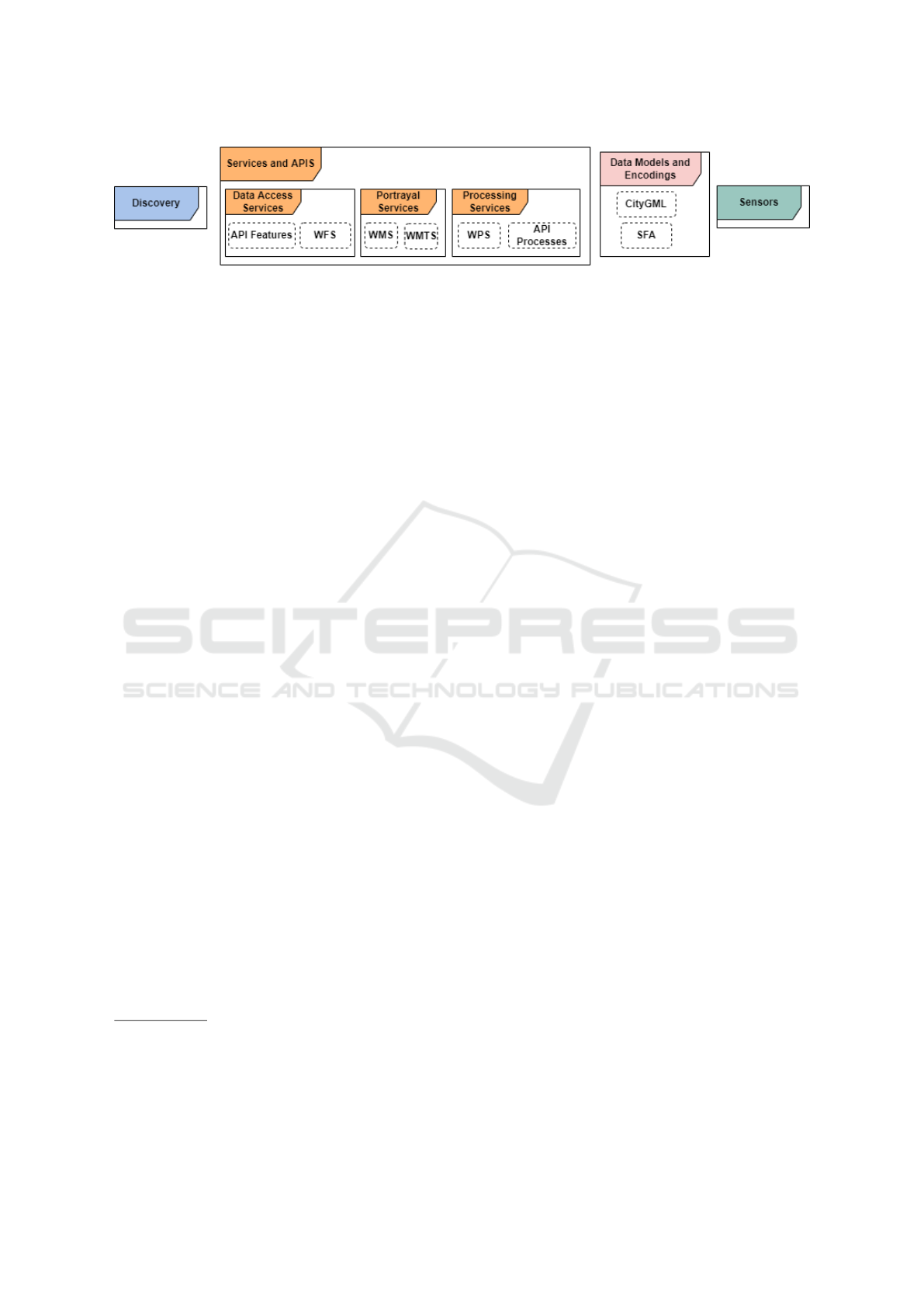
Figure 1: Selected OGC geospatial standards for smart cities.
3 MOTIVATING SCENARIO
This section describes a real-world smart city plat-
form in order to illustrate geospatial issues and re-
quirements within smart cities scenarios.
3.1 Montevideo Smart City Platform
and Applications
The Municipality of Montevideo (MM) deploys a
FIWARE-based SCP (MM SCP) that receives data
from a city-wide IoT sensor network (cf. Fig. 2.).
Data are generated by smart things (sensors and pri-
vate apps) and sent to IoT Agents, which invoke Con-
text Management components: Orion Context Bro-
kers
3
to process the incoming data, Apache Flume to
create an intermediate buffer before persisting data,
and MongoDB
4
and other databases to persist data.
The Data Viewing and Management applications
display real-time and statistical data using dashboards
and maps. The Public Applications include the MM
Portal and two geospatially-enabled applications that
use dynamic maps from server-side geospatial ser-
vices: the Buses App
5
and the Beaches App
6
.
The Buses App shows the real-time location of
buses on a map. The location is automatically sent by
every bus to the MM SCP. The Beaches App displays
information (e.g. current beach flag, algal bloom
warnings, etc.) that are daily uploaded to the MM
SCP by the staff (e.g. lifeguards) using a private app.
The following limitations are identified in this
scenario: (i) each application integrates geospatial
and smart things data using its own client-side code;
(ii) each application implements geospatial logic with
client-side code or server-side (not platform-side) ser-
vices; (iii) the MM SCP does not provide applications
with platform-side, geospatial components.
3
a Context Broker manages the entire lifecycle of con-
text information including updates, queries, registrations
and subscriptions in a smart cities platform
4
https://www.mongodb.com/
5
http://www.montevideo.gub.uy/buses/mapaBuses.html
6
http://montevideo.gub.uy/playas
3.2 Geospatial Issues and Requirements
for Smart Cities Platforms
Scenarios like the one described in Section 3.1 present
the following issues, which are depicted in Fig. 3.
1. Lack of an explicit geospatial integration
mechanism at the platform level: Since the SCP
does not provide an explicit mechanism to inte-
grate advanced geospatial capabilities, it is up to
each application to provide the integration logic
between SCP and geospatial logic, adding com-
plexity to each application and potential code du-
plication among applications.
2. Lack of complex geospatial logic at the plat-
form level: Since SCPs only support basic
geospatial capabilities, it is up to each application
to implement complex geospatial logic, resulting
in overly complex, unreusable logic in each appli-
cation, and potential code duplication among ap-
plications.
3. Sub-optimal use of geospatial standards: Since
geospatial capabilities are not available at the
platform level, applications often resort to non-
standard Web APIs (e.g. Google Maps API), mak-
ing standards adoption more difficult than when
the platform provides them.
To tackle the described issues, the following re-
quirements are proposed for a Geospatial Smart Cities
Platform (GeoSCP).
1. Provide an Explicit SCP and Geospatial Inte-
gration Mechanism: To facilitate application de-
velopment, the integration logic must be provided
at the platform level rather than at the application
level.
2. Support Standards-based Geospatial Logic: To
facilitate application development and promote
code reuse, the GeoSCP must support the incre-
mental deployment of complex geospatial logic
at the platform level, avoiding complex geospatial
logic at the application level.
3. Provide a General Architecture that Includes
Standards-Based Geospatial Capabilities: To
Standards-Based Geospatial Services Integration for Smart Cities Platforms
169
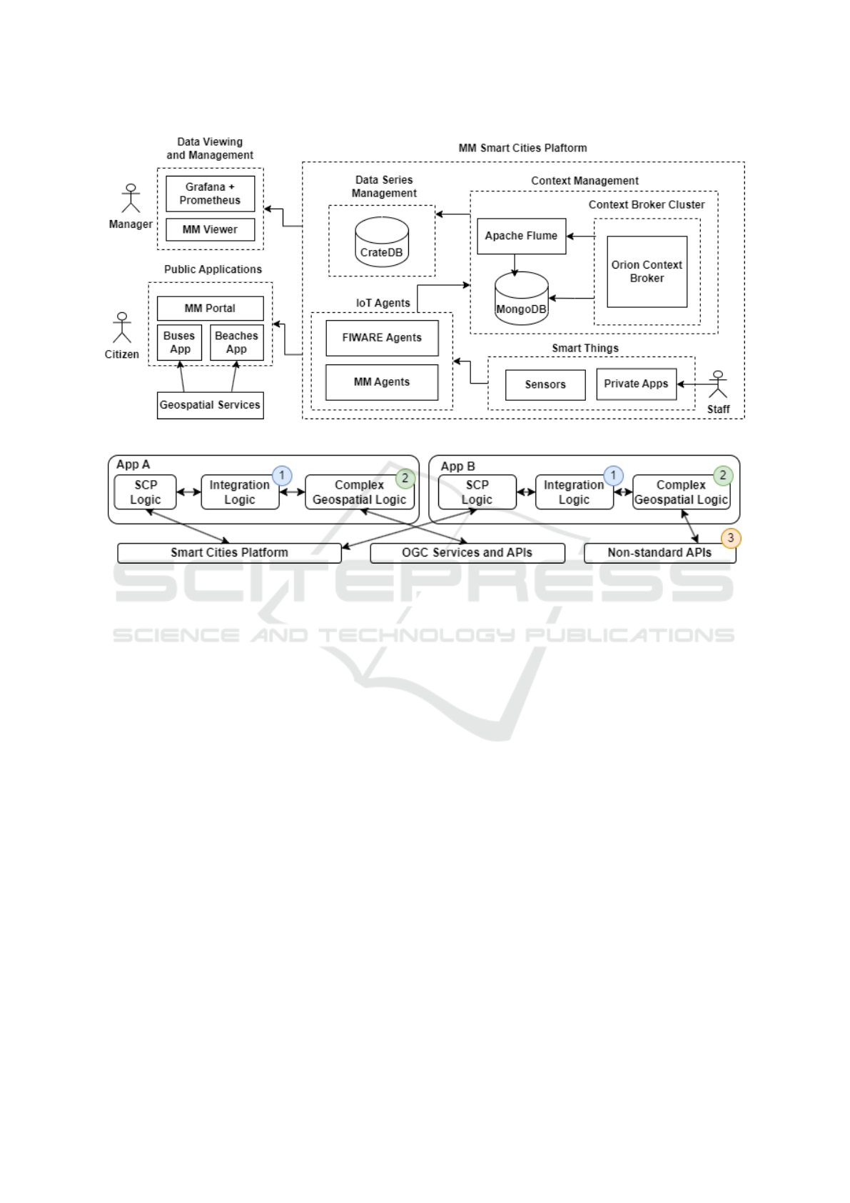
Figure 2: General architecture of MM SCP.
Figure 3: Issues in typical scenarios (numbers correspond to each issue).
prevent the use of geospatial capabilities through
non-standard APIs, the GeoSCP must provide the
equivalent standards-based capabilities in a well-
defined architecture.
In order to facilitate the long-term evolution of the
proposal and widen its applicability and interoperabil-
ity in the scope of other public smart cities initiatives,
the following non-functional aspects should be con-
templated: (i) low coupling of components to facil-
itate the substitution of any component; (ii) extensi-
bility of the provided geospatial standards; (iii) feasi-
bility to be implemented with open source software;
(iv) alignment to the reference architecture presented
in Section 2.1.
4 PROPOSED SOLUTION
This section describes the proposed solution in or-
der to provide a standards-based geospatial services
integration for smart cities platforms. A high-level
overview of the solution and its architecture is pre-
sented, as well as a description of the main compo-
nents and their interactions.
4.1 General Description and Main
Components
The proposed solution is a Geospatial Smart Cities
Platform (GeoSCP) that combines a Geospatial
Server with an SCP. A Geospatial Server is a spe-
cialised middleware that implements OGC standards.
More than one geospatial server type may be used to
implement all the necessary standards. The general
architecture of the solution is shown in Figure 4 and
its main components are described in what follows.
Other SCP components can be added for specific sce-
narios.
The Smart Cities Platform in this architecture rep-
resents an SCP with no native support for geospa-
tial capabilities. The main components are the IoT
Agents and the Context Broker, which are inspired by
the FIWARE architecture. The IoT Agents interact
with smart things and send data to the Context Broker
using a common Context Information Model (CIM)
API. Since not every smart thing implements the same
transport protocol (e.g. MQTT) or data exchange for-
mat (e.g. JSON), a specialised subtype of IoT Agent
with a different API for each combination of protocols
is needed. The Context Broker acts as the primary ac-
cess point to context information, using the same CIM
GISTAM 2023 - 9th International Conference on Geographical Information Systems Theory, Applications and Management
170
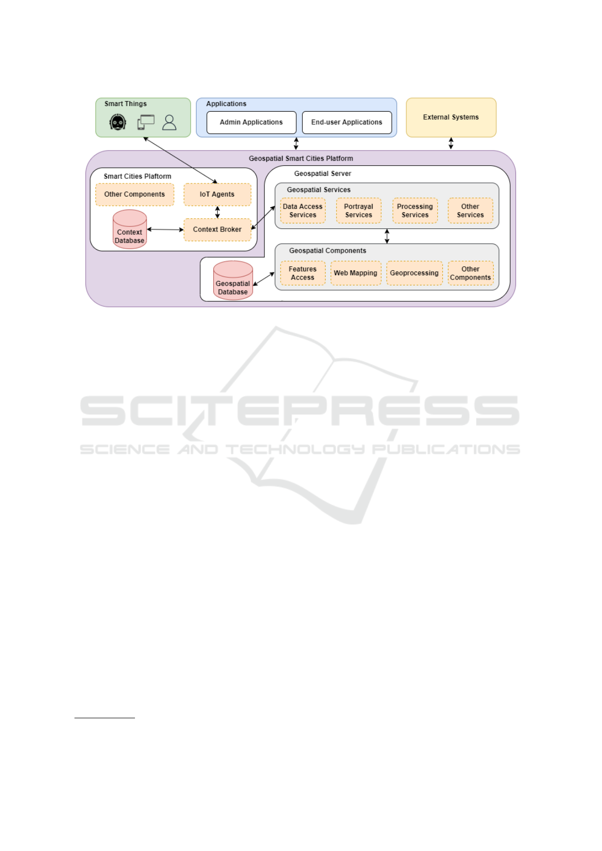
Figure 4: GeoSCP General Architecture.
as the IoT Agents. The Context Broker stores data
that is sent by IoT Agents in the Context Database
and uses the Publish-Subscribe pattern to send data to
subscribers.
The Geospatial Server, which offers an extensi-
ble set of services that can be invoked either by ap-
plications or by SCP components, is divided into
two layers. The Geospatial Services layer consists
of Data Access, Portrayal, and Processing services
among other services. The Geospatial Components
layer comprises components used by the services to
execute the business logic. The Features Access com-
ponent handles CRUD
7
operations on vector data,
stored in a Geospatial Database. The Web Mapping
component generates map images. The Geoprocess-
ing component provides the executable processes for
the Processing services.
The Smart Things component represents all the
devices that interact with a corresponding IoT Agent.
The Applications component represents the end-user
and admin applications that could potentially use the
geospatial capabilities of the GeoSCP. The Exter-
nal Systems component groups Web APIs, external
Geospatial Services, other SCPs, etc., that could be
used by the GeoSCP to complement its internal data
or functionalities.
4.2 Components Interactions
This section depicts the most common interaction
flows between components.
The Registration and Subscription Flow, shown
7
CRUD is the acronym of Create, Read, Update, Delete
in Figure 5, is performed when a new smart thing
is created in the SCP. First, an admin application or
an external system invokes the appropriate method
(e.g. CreateSmartThing) on the IoT Agent API. At
least the smart thing id and its type must be provided.
Next, the IoT Agent invokes a method (i.e. RegisterS-
martThing) to register the smart thing on the Context
Broker. The IoT Agent API may vary according to
its subtype, but the Context Broker always uses the
same CIM API, as was explained in Section 4.1. Fi-
nally, the admin application or external system creates
a new subscription in the Context Broker. The sub-
scription tells the Context Broker that when a smart
thing of a certain type sends a notification that satis-
fies a certain condition, some geospatial service end-
point has to be invoked. For instance, the smart thing
could be a bus (type=Bus) that reports certain values
like its location, speed, etc. The condition in the sub-
scription could specify that a Data Access Service is
invoked each time the bus sends a new location value.
The Notification Flow, shown in Figure 6, is per-
formed when a smart thing sends some updated data
to the SCP. First, the smart thing invokes the appro-
priate method (e.g. UpdateValue) on the IoT Agent
API. At least, the smart thing id, the attributes that
are being reported (e.g. the location, speed) and the
new values for those attributes type must be provided.
Next, the IoT Agent invokes a method (e.g. Update-
Context) to send the updated values to the Context
Broker and the Context Broker updates the values be-
longing to the originating smart thing in the Context
Database. At this moment, the Context Broker has to
verify that there is a subscription that matches the type
(e.g. type=Bus) and that the attributes being updated
Standards-Based Geospatial Services Integration for Smart Cities Platforms
171
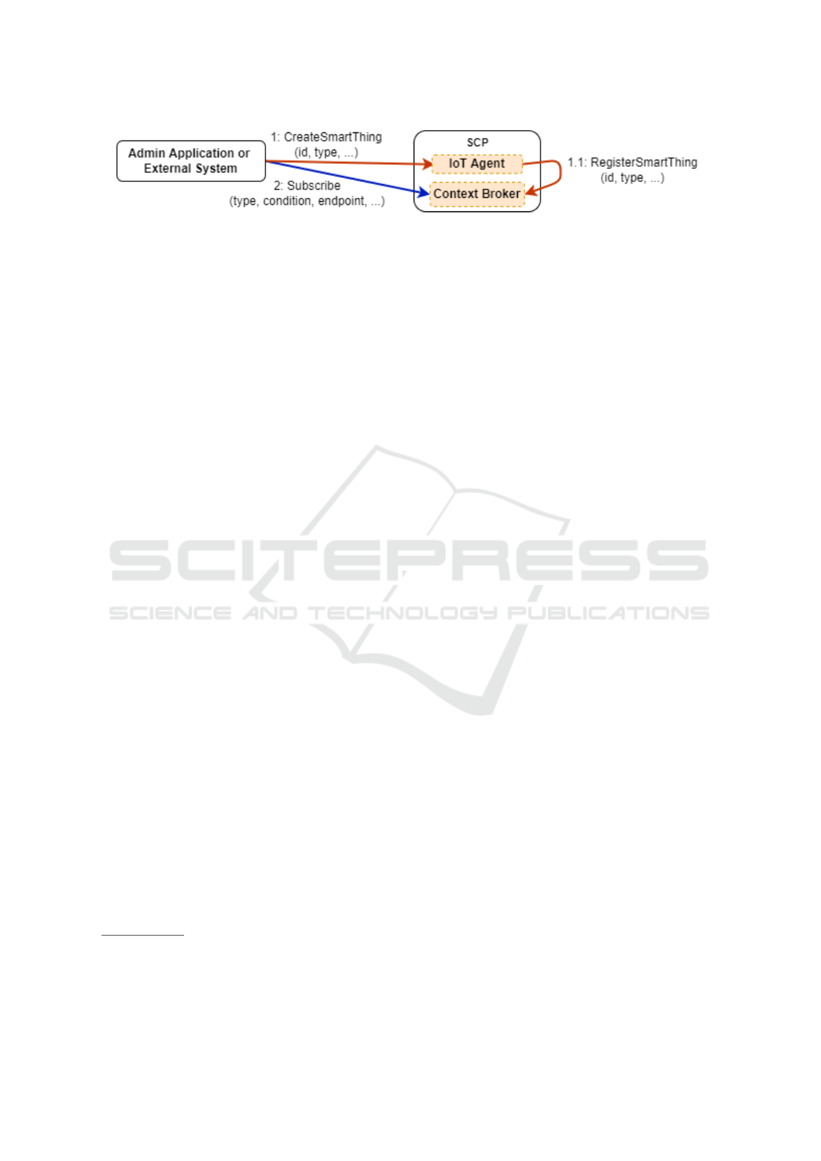
Figure 5: Smart thing registration and subscription creation.
(e.g. location) match the condition of the subscrip-
tion. If both conditions hold true, the endpoint that
was specified with the subscription is invoked (e.g.
the GeospatialOperation of a Geospatial Service).
5 IMPLEMENTATION AND
ASSESSMENT DETAILS
A prototype of the proposed GeoSCP and three smart
cities applications (based on GeoSCP) were devel-
oped, which provides a reference implementation for
the proposal. This section provides implementation
and assessment details.
5.1 Implementation Details
The GeoSCP implementation (Abell
´
a et al., 2021),
whose architecture is shown in Fig. 7, is based on FI-
WARE and includes a Geospatial Server provided by
Pygeoapi
8
(Python implementation of the OGC API
suite of standards). The OGC APIs (e.g. API Pro-
cesses) were favoured over the OGC Web Services
(e.g. WPS) because they are based on RESTful inter-
faces with JSON payloads, which goes in line with
FIWARE APIs. The Geoprocessing subcomponent
is used by the API Processes and includes the sup-
porting processes for the developed applications, but
may be reused by other applications. The SFA com-
ponent is used by the API Features and allows access
to 2D vector data (e.g. bus routes) in the PostgreSQL
9
database.
Based on the implemented GeoSCP prototype,
three smart cities applications were developed: Bus
Detours, Beach Ranking, and Sensor Management
10
.
The Sensor Management application manages the
sensor’s life cycle, using the Registration and Sub-
scription Flow (cf. Section 4.2), and generates
simulated data for the other applications, using the
platform-side SensorProcess.
The Beach Ranking application let citizens know
if a beach is too crowded before arriving. It leverages
8
https://pygeoapi.io
9
https://www.postgresql.org/
10
Code and screenshots available at: www.fing.edu.uy/
owncloud/index.php/s/WxOommkYExin427
sensors at beach entrances to detect people coming in
and out and uses the platform-side RankingProcess,
which receives data from sensors, counts the people at
a certain beach, and divides that number by the beach
area, generating a crowding index.
The Bus Detours application shows unexpected
bus detours (e.g. because of accidents) using the
platform-side DetourProcess, which receives the real
position of every bus and informs its location as well
as route changes in real-time.
The Ranking and Detour processes follow the No-
tification Flow (cf. Section 4.2) and are published
through the API Processes.
In conclusion, the GeoSCP-based applications
(Beach Ranking and Bus Detours) show that it is pos-
sible to achieve a similar level of functionality than
that provided by the MM SCP applications (Busses
and Beaches Apps) with the following advantages: (i)
the integration between the SCP and the geospatial
logic is transparent to the applications, (ii) complex
geospatial logic is implemented as platform-side pro-
cesses, facilitating application development and code
reuse and (iii) promoting the use of an unified service
interface based on OGC standards.
5.2 Assessment and Discussion
The assessment of the technical feasibility of the so-
lution was carried out through the development of a
platform prototype and three applications, which con-
stitute a reference implementation of the solution (cf.
Section 5.1).
The three main requirements that were proposed
in Section 3.2 are met in the solution. The first
one was achieved by leveraging the platform-level
Publish-Subscribe mechanism to invoke geospatial
services in an event-driven fashion, which prevents
applications from implementing the integration logic.
The second requirement was achieved by provid-
ing standards-based Processing Services to support
platform-level, reusable geospatial processes, simpli-
fying the geospatial logic in applications. The third
requirement was achieved by integrating a standards-
based Geospatial Server with a well-defined architec-
ture of geospatial services and components.
The non-functional requirements were addressed
in the following way. The low coupling was achieved
GISTAM 2023 - 9th International Conference on Geographical Information Systems Theory, Applications and Management
172
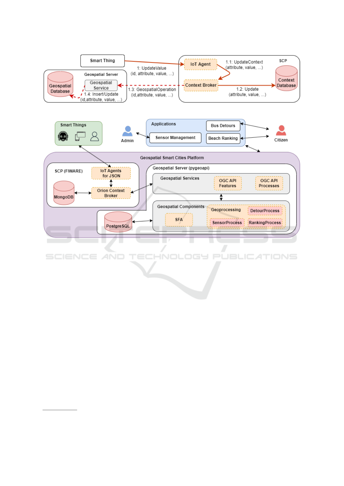
Figure 6: Update values and invoke Geospatial Service.
Figure 7: High-level architecture of the implemented solution.
by the use of the Publish-Subscribe mechanism,
which makes the inclusion or substitution of geospa-
tial services completely transparent to the other com-
ponents of the architecture (i.e. SCP, applications,
smart things, etc.). By using this mechanism, pub-
lishers (e.g. smart things) are loosely coupled to sub-
scribers (e.g. geospatial services) since there are not
any direct calls between them (Hohpe and Woolf,
2003). The extensibility of standards was achieved
by the inherent extensibility provided by the Geospa-
tial Server and the possibility to add other types of
geospatial servers (e.g. GeoServer
11
could be added
to support WFS and WPS that are not supported by
pygeoapi). The feasibility of a complete implementa-
tion based on open-source software was demonstrated
with the use of open-source components exclusively
(e.g. Orion, pygeoapi). The alignment to the refer-
ence architecture is established by the following map-
ping between component types in each architecture:
a Portrayal component is a Visualization component,
the Features Access, and Geoprocessing components
are Analytics components, the Geospatial Database is
a Model Repository, the Geospatial Services are Ser-
11
https://geoserver.org/
vice Middleware, the ContextBroker and IoT Agents
are IoT Middleware; the Context Database is a Data
Repository; Bus Detours and Beach Ranking are Cit-
izen Applications, Sensor Management is a Manager
application.
6 RELATED WORK
The integration of geospatial technologies within
smart cities solutions has been addressed in differ-
ent proposals (Bhattacharya and Painho, 2018)(Al-
Hader et al., 2009)(Souza et al., 2017)(Yan et al.,
2022)(Chaturvedi and Kolbe, 2019).
Souza et al. (Souza et al., 2017) describe the im-
plementation of the Smart Geo Layers middleware
and its use in an urban planning application for a
smart cities initiative in Natal, Brazil. The main goals
of this middleware are to unify and normalise data
from various sources, to insert geospatial information
related to physical spaces, and to include visualisation
as well as data analysis functionalities. Compared to
our work, this proposal performs the integration at
the data level (not supporting advanced functionali-
Standards-Based Geospatial Services Integration for Smart Cities Platforms
173

ties such as geospatial processes), and it is not based
on OGC standards for geospatial services and APIs.
Yan et al. (Yan et al., 2022) propose a Geo
Cyber-Physical System Platform for designing smart
cities, which leverages cyber-physical systems, GIS,
and touchable user interfaces (TUI). The platform
provides mechanisms for connecting these three el-
ements, enabling interactive sensing, processing, and
actuation in smart city development. Compared to our
work, this proposal is broader since it addresses inte-
gration with TUI. However, it is neither as detailed as
ours regarding the specific geospatial services to pro-
vide nor is based on OGC standards.
Bhattacharya et al. (Bhattacharya and Painho,
2018) propose SmaCiSENS: a globally shared open
spatial expert system, providing a geo-enabled knowl-
edge based for smart cities. The proposal addresses
the integration of interfaces and functions of Spatial
Data Infrastructures (SDI) and Sensor Web (SW), as
well as sensor data application program interfaces for
smart cities. Compared to our work, this proposal also
leverages OGC standards but it focuses on the integra-
tion of SDI and SW.
Chaturvedi et al. (Chaturvedi and Kolbe, 2019)
propose a Web service called InterSensor Service that
allows to connect to multiple IoT platforms, simula-
tion data, databases, and simple files to retrieve ob-
servations independently of data storage and specific
APIs. The service encodes these observations “on-
the-fly” according to interfaces such as the OGC SOS
and OGC SensorThings API, offering a unified API
for the applications. Compared to our work, this
proposal does not address the integration of generic
geospatial services (e.g. Data Access Services, Pro-
cessing Services, etc.) into an existing SCP to pro-
vide complex geospatial logic to applications, but in-
stead it focuses on providing a standardized interface
to applications that can act as SOS and SensorThings
clients.
7 CONCLUSIONS AND FUTURE
WORK
This paper proposed GeoSCP: a standards-based so-
lution for geospatial services integration for SCPs.
The proposal comprises an overall architecture as
well as a reference implementation based on FIWARE
and includes three applications.
The development of the proposal was driven by
requirements of smart cities scenarios, illustrated by
a real-world case (i.e. MM SCP), in which SCPs do
not provide built-in components to support geospa-
tial capabilities. The proposed solution addressed
the identified requirements by: i) providing an ex-
plicit SCP and geospatial integration mechanism;
ii) supporting standards-based geospatial logic; and
iii) providing a general architecture with standards-
based geospatial capabilities. In addition, it contem-
plates non-functional aspects regarding the low cou-
pling of components, geospatial standards extensibil-
ity, open-source implementation, and alignment with
a reference architecture. The technical feasibility of
GeoSCP was assessed through the development of a
prototype and three applications.
The main contribution of this work is the overall
architecture proposal for integrating standards-based
geospatial services with SCPs as well as its refer-
ence implementation. These results can be leveraged
by smart cities initiatives to enhance their SCPs with
geospatial capabilities, to enable and promote im-
plementation agility, maintainability, reuse, and stan-
dards adoption for their smart cities applications re-
quiring geospatial support.
Future work includes: i) assessing the proposal
with other SCP (e.g. InterSCity) and other geospatial
servers (e.g. GeoServer); ii) extending the reference
implementation with other geospatial services and ap-
plications; and iii) advancing in the validation of the
proposal in real-world cases.
ACKNOWLEDGEMENTS
The authors would like to thank the Department of
Sustainable and Smart Development of the Munici-
pality of Montevideo for providing us with the re-
quired insight into their Smart City Platform which
was a key asset for the definition of the motivating
scenario.
REFERENCES
Abell
´
a, G., Machado, A., and Susviela, D. (2021). Tec-
nolog
´
ıas geoespaciales en plataformas de smart cities.
Undergraduate thesis, Facultad de Ingenier
´
ıa, Univer-
sidad de la Rep
´
ublica (Uruguay).
Ahad, M. A., Paiva, S., Tripathi, G., and Feroz, N. (2020).
Enabling technologies and sustainable smart cities.
Sustainable Cities and Society, 61:102301.
Al-Hader, M., Rodzi, A., Sharif, A. R., and Ahmad, N.
(2009). Soa of smart city geospatial management.
In 2009 Third UKSim European Symposium on Com-
puter Modeling and Simulation, pages 6–10.
Alberti, A. M., Santos, M. A. S., Souza, R., Da Silva, H.
D. L., Carneiro, J. R., Figueiredo, V. A. C., and Ro-
drigues, J. J. P. C. (2019). Platforms for smart envi-
GISTAM 2023 - 9th International Conference on Geographical Information Systems Theory, Applications and Management
174

ronments and future internet design: A survey. IEEE
Access, 7:165748–165778.
Bhattacharya, D. and Painho, M. (2018). Location intel-
ligence for augmented smart cities integrating sen-
sor web and spatial data infrastructure (smacisens).
In GISTAM 2018-Proceedings of the 4th Interna-
tional Conference on Geographical Information Sys-
tems Theory, Applications and Management, volume
2018, pages 282–289. SciTePress-Science and Tech-
nology Publications.
Br
¨
oring, A., Stasch, C., and Echterhoff, J. (2012). OGC
Sensor Observation Service Interface Standard. Re-
port, Open Geospatial Consortium.
Chaturvedi, K. and Kolbe, T. H. (2019). Towards estab-
lishing cross-platform interoperability for sensors in
smart cities. Sensors, 19(3).
da Silva, T. P., Batista, T., Lopes, F., Neto, A. R., Deli-
cato, F. C., Pires, P. F., and da Rocha, A. R. (2021).
Fog computing platforms for smart city applications -
a survey. ACM Trans. Internet Technol.
Daniel, S. and Doran, M.-A. (2013). Geosmartcity: Geo-
matics contribution to the smart city. In Proceedings
of the 14th Annual International Conference on Digi-
tal Government Research, dg.o 13, page 65–71, New
York, NY, USA. Association for Computing Machin-
ery.
de la Beaujardiere, J. (2006). OpenGIS Web Map Server
Implementation Specification. Report, Open Geospa-
tial Consortium.
de Vries, W. (2021). Trends in the adoption of new geospa-
tial technologies for spatial planning and land man-
agement in 2021. Geoplanning: Journal of Geomatics
and Planning, 8(2):85–98.
Herring, J. (2011). OpenGIS Implementation Standard for
Geographic information - Simple feature access - Part
1: Common architecture. Report, Open Geospatial
Consortium.
Hohpe, G. and Woolf, B. (2003). Enterprise Integration
Patterns: Designing, Building, and Deploying Mes-
saging Solutions. Addison–Wesley.
ITU (2018). Recommendation ITU-T Y.4201: High-level
requirements and reference framework of smart city
platforms. Technical report, International Telecom-
munication Union.
Kolbe, T. H., Kutzner, T., Smyth, C. S., Nagel, C., Roens-
dorf, C., and Heazel, C. (2021). OGC City Geogra-
phy Markup Language (CityGML) Part 1: Concep-
tual Model Standard. Report, Open Geospatial Con-
sortium.
Lee, C. and Percivall, G. (2008). Standards-based comput-
ing capabilities for distributed geospatial applications.
Computer, 41(11):50–57.
Liang, S., Khalafbeigi, T., and van der Schaaf, H. (2021).
OGC SensorThings API Part 1: Sensing Version 1.1.
Report, Open Geospatial Consortium.
Mas
´
o, J., Pomakis, K., and Juli
`
a, N. (2010). OpenGIS Web
Map Tile Service Implementation Standard. Report,
Open Geospatial Consortium.
Mueller, M. and Pross, B. (2018). OGC WPS 2.0.2 Interface
Standard. Report, Open Geospatial Consortium.
Percivall, G. (2015). OGC Smart Cities Spatial Information
Framework. Report, Open Geospatial Consortium.
Percivall, G. (2020). OGC Abstract Specification Topic 0 -
Overview. Report, Open Geospatial Consortium.
Portele, C., Vretanos, P. P. A., and Heazel, C. (2018). OGC
API - Features - Part 1: Core. Report, Open Geospa-
tial Consortium.
Pross, B. and Vretanos, P. P. A. (2021). OGC API - Pro-
cesses - Part 1: Core. Report, Open Geospatial Con-
sortium.
Saborido, R. and Alba, E. (2020). Software systems from
smart city vendors. Cities, 101:102690.
Santana, E. F. Z., Chaves, A. P., Gerosa, M. A., Kon, F.,
and Milojicic, D. S. (2017). Software platforms for
smart cities: Concepts, requirements, challenges, and
a unified reference architecture. ACM Comput. Surv.,
50(6).
Sharma, P., Singh, R., and Srivastava, A. (2021). Analyzing
the Role of Geospatial Technology in Smart City De-
velopment, pages 1–20. Springer International Pub-
lishing, Cham.
Souza, A., Pereira, J., Oliveira, J., Trindade, C., Cavalcante,
E., Cacho, N., Batista, T., and Lopes, F. (2017). A
data integration approach for smart cities: The case of
natal. In 2017 International Smart Cities Conference
(ISC2), pages 1–6.
Vretanos, P. P. A. (2010). OpenGIS Web Feature Service
2.0 Interface Standard. Report, Open Geospatial Con-
sortium.
Yan, W., Kiyoki, Y., and Murakami, Y. (2022). The Geo
CPS Platform for Designing Smart Cities.
Standards-Based Geospatial Services Integration for Smart Cities Platforms
175
