
Combining Clustering Algorithms to Extract Symmetric Clusters from
Noisy Data, Applied to Parking Lots
Gyulai-Nagy Zolt
´
an-Valentin
a
Department of Computer Science, Babes¸-Bolyai University,
1, M. Kogalniceanu Street, 400084, Cluj-Napoca, Romania
Keywords:
Clustering, SOM Clustering, HDBSCAN, K-Means, Real-Time Application, Automation, Parking Lot Space
Detection, Feature Extraction.
Abstract:
The paper presents an approach for detecting symmetrical clusters in noisy data, using parking space de-
tections as a real-world example. The paper proposes a plug-and-play solution that uses camera systems to
automatically detect parking spaces and provide metrics about availability and accuracy. The approach uses
clustering algorithms and image detection for data acquisition and mapping, which can be easily adapted to
any application that requires geometrical data extraction. The paper also presents the different phases involved
in mapping parking spaces and the challenges that need to be addressed. Overall, the proposed approach can
benefit both parking lot administrators and drivers by providing real-time information on available parking
spaces and reducing emissions, fuel costs, traffic, and time spent searching for a spot.
1 INTRODUCTION
Detecting where there are free spaces in a parking
lot has always been a complex problem. In previ-
ous years, as cars play a great role in our day-to-day
means of transportation, cities got agglomerated and
therefore, it is harder and harder to find free spaces
in parking lots. One might spend more time search-
ing for an available space in big cities than traveling
to the destination. We need to also take into account
the pricing of leaving your car at a lot. When in high
demand due to having a preferential placement in the
central area, the price might be a bit higher when com-
pared to other options. One might park farther from
their destination to avoid paying higher fees. Lately,
there have been a few initiatives to incentivize peo-
ple to use public transportation for daily activities, but
this does not seem to solve the problem of parking
lot availability, as space is limited in crowded cities.
(Cooke and Behrens, 2017) It would be helpful to just
open an application and see in real-time where we
might have the chance to find available spaces. This
would also contribute to reduced emissions, therefore
a greener environment, cost savings on fuel, reduced
traffic, and time efficiency, due to not being required
to search for a space.
a
https://orcid.org/0000-0001-6506-4679
This paper will focus on combining clustering al-
gorithms to detect parking spaces based on positional
data. Unlike other approaches, we provide a plug-
and-play solution that does not require user-provided
information at all, provides metrics and insights, re-
lies on potentially existing equipment, can automati-
cally adapt to any topology, and does not require com-
plex setup or hardware.
2 LITERATURE REVIEW
In the past, the topic of detecting the occupancy of
parking lots has been answered with different kinds
of approaches. One of the most straightforward ones
is manually marking the spaces and using simple im-
age recognition on cars to predict occupancy. This has
evolved into a race where applications try to detect the
spaces automatically using the available data from im-
ages. This approach uses features that might delimit
a space, like markers placed on the ground (Acharya
et al., 2018). Other similar approaches try to optimize
the images further to reduce the impact of lightning
conditions or glare (Huang et al., 2022). Further re-
search has been conducted to rely only on the position
of the vehicles. Although a camera is still required,
using positional data also has advantages when con-
sidering unmarked spots. This involves using cluster-
362
Zoltán-Valentin, G.
Combining Clustering Algorithms to Extract Symmetric Clusters from Noisy Data, Applied to Parking Lots.
DOI: 10.5220/0012624400003687
Paper published under CC license (CC BY-NC-ND 4.0)
In Proceedings of the 19th International Conference on Evaluation of Novel Approaches to Software Engineering (ENASE 2024), pages 362-369
ISBN: 978-989-758-696-5; ISSN: 2184-4895
Proceedings Copyright © 2024 by SCITEPRESS – Science and Technology Publications, Lda.

ing and predefined information about the lot (Grbi
´
c
and Koch, 2023). Another more popular approach,
due to its applicability to a large variety of topolo-
gies, is to use sensors placed in the ground or above
the cars to detect occupancy. This approach has the
advantage of not requiring a camera. Therefore, in-
formation that might be private to drivers but embed-
ded in the images, like car plates, doesn’t need to be
trimmed off, and potential security breaches are ex-
cluded. It requires more manual setup, but once done,
it provides accurate data (Zhang et al., 2015). Mod-
ern vehicles are being equipped with multiple types
of sensors and cameras. Some approaches try to use
them to provide information about parking lots. This
has the advantage of not requiring the installation of
new sensors (Luo et al., 2017).
Previous research has explored the combination
of clustering methods, revealing that leveraging re-
sults from multiple algorithms can indeed enhance
accuracy in distinguishing members across multiple
clusters. (Khedairia and Khadir, 2022) Another pa-
per delves into the effectiveness of amalgamating K-
means with Genetic Algorithms, leading to processes
that are both more accurate and efficient. (Zeebaree
et al., 2017) Additionally, research has demonstrated
that combining weak clustering algorithms can fur-
ther enhance the accuracy of the outcomes. (Topchy
et al., 2003). In conclusion we can state that there
can be benefits in terms of performance and accuracy
when well known algorithms are combined.
Furthermore, a noteworthy aspect pertinent to our
methodology is the intriguing research where it was
proven that by inputting initial recognition data from
image processing into a neural network with the inten-
tion of retraining it, we can attain improved classifi-
cation performance (Doulamis et al., 2000). All these
findings contribute to our methodology and provide
the basis for our contribution.
3 PROBLEM STATEMENT AND
RESEARCH QUESTIONS
Mapping of parking spaces is a complex operation
and requires multiple phases to achieve adequate re-
sults without relying on any kind of user input. The
adaptability to changes in the topology and providing
metrics also means that we need to do continuous pro-
cessing, and the results need to be as accurate as they
can get between each mapping phase to provide value
in real-world applications. In the following subsec-
tions, we are going to provide details on each phase
and the problem that they need to solve.
3.1 Data Acquisition and Preprocessing
First of all, we need to acquire the data that will be
used further in the next phases. In our application, we
want to rely on camera images as lots of parking lots
already have them placed due to security measures.
This also means that images should cover most of the
available area. In this paper, we will exclusively fo-
cus on scenarios where a single camera constructs the
topology of a parking lot. This choice doesn’t com-
promise the plug-and-play functionality of the sys-
tem; rather, it maintains it for single-camera setups.
However, future enhancements can extend this capa-
bility to derive topology from multiple camera angles,
resulting in more precise data.
Most cameras are placed higher above ground to
cover as much space as they can. The angle of view
and lens distortion are factors that we need to take into
consideration. We can work with non-uniform data
as it is going to be presented in the next sections, but
transforming the data is going to provide further bene-
fits in distinguishing symmetrical features. Therefore
the first research question is phrased as follows:
RQ1 What is the most appropriate transformation for
the data to illustrate the symmetrical features?
3.2 Data Denoising
By using the detected cars in the image, we are go-
ing to have lots of noise. This is because even if we
process the images from a feed at a given time inter-
val, there is going to be movement of departing and
arriving cars.
We also need to take into consideration that we
might have such areas in a parking lot where illegal
parking occurs. By illegal parking, we don’t mean it is
punishable by law to leave the car there; that’s a factor
that might be unreliable to be extracted purely from
images, and it’s not in our scope. We actually mean
that space is not designated to be used as a parking
space, and even so, people leave their cars there as it
won’t impact other drivers’ access to other spaces.
This would provide valuable insight for drivers to
determine by their arrival how likely it is to find their
chosen space occupied. Given the previous informa-
tion, we can conclude our interests:
RQ2. What algorithm can denoise and regularize the
data?
3.3 Determining the Number of Parking
Spaces
We need to take into consideration lots of variables in
the detected data when we want to determine the num-
Combining Clustering Algorithms to Extract Symmetric Clusters from Noisy Data, Applied to Parking Lots
363
ber of available parking spaces. Depending on how
people park their cars, in the more accessible spaces,
we are going to have much denser data, whereas in ar-
eas that are like a fallback to if the main places are oc-
cupied, we are going to have much fewer data points.
Therefore if a parking lot is frequently at its peak ca-
pacity, we have a greater uniformity in data, but we
can’t solely rely on that as we want our approach to
work on less frequented lots too. If the detected data
is not dense enough, we might want to consider them
as noise, but in time as the samples increase, it is de-
sired that they get to be detected as valid points.
A small memory-like approximation is also de-
sired. As the topology of a parking space does not
really change too often and the camera is also kept in
the same place, remembering on a short term where
there were the previous detections it’s a helpful fea-
ture. We can also extract further data from these de-
tections and we can make sure that if, for instance, the
camera deteriorates and it’s noticed in a short period
of time, we still have stable estimations based on past
data.
RQ3. What algorithm can delimit clusters via data
frequency and can keep them in memory?
3.4 Parking Space Assignments and
Real-Time Detection
As a final phase, we want to detect a lot’s occupancy
in real time. For this, we need an estimate for the size
of each parking space and their center point. We also
need to detect the center points of the clusters in such
a way that they’re placed in the most dense area. It
is important to delimit the parking spaces by priori-
tizing the Euclidean distances between them to avoid
putting more clusters than needed over areas that are
highly dense in data.
RQ4. What algorithm is capable of accurately posi-
tioning centroids based on Euclidean distance?
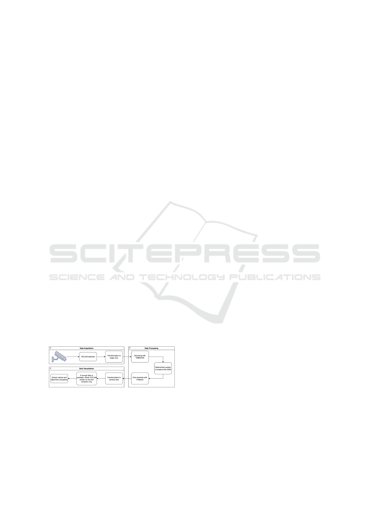
Figure 1: Steps of data processing.
4 METHODOLOGY
We will use a multi-step process to provide real-time
data about the occupancy of parking spaces. We can
differentiate two streams in this process: one is re-
sponsible for creating the parking lot model, and the
second is providing real-time metrics and data. In the
following subsections, we are going to describe them.
An overview of the following steps can be found in
Figure 1.
4.1 Data Acquisition and Preprocessing
For this section, we are going to use the PKLot dataset
(de Almeida et al., 2015). It provides images of a
parking lot over a longer period of time, and it covers
multiple scenarios like daytime images, nighttime im-
ages, and different types of weather conditions. The
angle of the camera is positioned in such a way that
it covers the lot. It contains scenarios where the cars
are not only in preferred positions, like stationed in a
parking lot, but also when they are moving in and out
of the parking spaces. It also contains images where
people leave cars in unmarked spots. Basically, it con-
tains most scenarios that are going to be covered when
we use a camera stream and pick a few images at pre-
defined time distances to be processed. As we want to
cover real-world scenarios, this is a viable database.
To detect the cars in the images, we are going to
use YOLOv8 (8th version of YOLO model). In the
past few years, it has been one of the best solutions
when talking about real-time detection of different
types of objects (Terven and C
´
ordova-Esparza, 2023).
The accuracy of detections is good, the lighting con-
ditions do not have such a significant impact on the
results, and it has configurable models depending on
what accuracy we want to achieve. It is a good can-
didate to be used on small devices like Raspberry Pi’s
that can be extended with camera modules. This is
important because, as previously mentioned, data pri-
vacy is an essential factor when images are involved.
Using a device that can do the processing on the spot
reduces the risk of leaking additional, potentially pri-
vate, information via internet connections. We as-
sume that having the flexibility to choose between dif-
ferent types of models can bring further advantages
in the cost optimization domain. Going forward we
are going to use the YOLOv8n (8th version of YOLO
model with 3.2 million parameters) model, but we are
going to include in the tests other models too.
Once the cars are detected in the images, we are
going to store the center points of the bounding boxes.
These points need to be processed further to better
indicate the symmetry between the parking spaces.
Due to a lack of raw dept information, the eagle view
seems to be the desired way of viewing the data, as the
dimensionality of the points is reduced from 3D to 2D
by trimming out the depth of field. We can achieve
this by various methods, but via recent research, we
ENASE 2024 - 19th International Conference on Evaluation of Novel Approaches to Software Engineering
364

can easily do so with geometric approaches (Abbas
and Zisserman, 2020). We can use the vertical van-
ishing point and ground plane vanishing lines to com-
pute a homography matrix that will transform the
data. These can be computed by using a Convolu-
tional Neural Network (CNN) trained in this scope.
The network is trained on a large amount of synthetic
images with known camera configurations.
After the perspective transformation is applied, we
are going to pass the data to the next phase.
In the next step, we are going to use HDBSCAN
clustering. It extends DBSCAN into a hierarchical
clustering algorithm that is able to find clusters with
varying densities. The only parameter that we are go-
ing to use as input is the number of minimum cluster
sizes. As we don’t have an exact number for that,
we are going to iterate over a few values to remove
the noise. If our data is entirely evenly distributed
in the parking lot, we could use 2882 as the starting
value, and the resulting cluster number should be 24.
This won’t be the case as the spaces on the right side
of the image are less frequented, and the YOLOv8n
model will have fewer detections due to image dis-
tortion. We are going to use this value as a starting
point, and we are going to decrease it until we get to
at least 24 detected clusters. Once we have that value,
we consider a simple rule to eliminate clusters that
are too large and present irregularities. For each itera-
tion going forward, we calculate the average width of
the clusters. Everything that is larger than the average
times two is going to be flagged. We chose this met-
ric because we assume that the spaces are symmetric,
meaning that if the width of a cluster is double com-
pared to the average, it can be split into two additional
clusters. We decrease the minimum cluster size by
100 and clusterize the data again. The 100 is a num-
ber that provides enough granularity in the iterations.
A smaller number can be used, but it would result in
more iterations. In case a larger cluster breaks into
smaller ones, and the total number of flagged clus-
ters also decreases, having noise points increasing,
we remove the previously flagged clusters. We aim
to find scenarios where clusters are not separated and
symmetrical enough, and they are connected in some
grade. This ensures we remove clusters that are too
large and can’t be clearly classified as parking spaces.
To better understand the iterations, the following bul-
let points summarize the steps: (1) Determine the av-
erage max width of clusters. (2) Flag the clusters that
are larger than the double of average width. (3) If
there are fewer flagged clusters compared to the pre-
vious step and there is additional noise, remove the
previously flagged clusters. (4) Decrease min cluster
size with 100 (or any smaller number).
The process stops once we get to a minimum clus-
ter size smaller or equal to the decrease value (100) or
when the number of detected clusters on the original
data is closest to the maximum number of detected
cars in an image, which is 64 in this case.
The presented method defines constraints for up-
per and lower boundaries for the denoising algorithm,
efficiently removing noise and clusters with ambigu-
ous symmetry. As we can see in the images, the num-
ber of resulting clusters is approximately close. How-
ever, further processing needs to be done to define the
exact number of parking spaces due to the wide vari-
ety of densities.
4.2 Determining the Number of Parking
Spaces
This phase aims to determine the number of parking
spaces that are available in the parking lot. For this
purpose, we are going to use the self-organizing maps
(SOM) (Miljkovi
´
c, 2017).
Due to other neural network properties, we will
have the benefit of short-term memory. This is useful
if the network is retrained with faulty data; previous
information will leave its mark on the model, and we
might be able to detect previously presented spaces
that have been removed from the lot for a short period
of time. This provides further metrics for the input
data in determining the probability of detecting park-
ing spaces.
Once we have trained the SOM model, we are go-
ing to extract the distance map. This enables us to
visualize the distance of nodes compared to neighbor-
ing ones. We are going to map the values to white and
black, white representing the most distant nodes and
black the closest ones. To further extract information
from the image, we are going to apply a few image
processing algorithms to make everything more inter-
pretable. We apply an adaptive histogram equaliza-
tion to increase the contrast. This is also useful be-
cause where we have color information, they are go-
ing to be more accentuated, but where we have black
shades, the new values are still going to be close to
each other. (Pizer et al., 1987) This approach has a
slight drawback; even though the information is eas-
ier to interpret, the noise can get overamplified. To
solve this issue, we are going to apply a local mean
filter with a low neighboring pixel check to the image.
This ensures that noise is reduced, and we can easily
extract the number of clusters shown in the image.
To do so, we will use a simple watershed algorithm
where the number of clusters will represent the num-
ber of parking spaces in our lot. The algorithm places
the starting points for the fill process in the areas of
Combining Clustering Algorithms to Extract Symmetric Clusters from Noisy Data, Applied to Parking Lots
365

the image that have the least gradient change.
Now that we have the actual number of spaces and
we have access to the denoised data, we can continue
to the following phase.
4.3 Parking Space Assignments
At this step and also the final processing step, we
have access to the denoised data and the number of
available spaces. We need to define the cluster cen-
ters precisely and transform them back to the original
information presented in the image to be visually in-
spected. For this purpose, we are going to use the
KMeans algorithm. It is highly efficient in assigning
each data point to the nearest cluster and minimizing
distance variances in clusters based on the Euclidean
distance. Even though it is a computationally de-
manding process, the partitioning converges quickly
to the local minimum (Ahmed et al., 2020). Only one
input parameter is required, that being the number of
clusters, but we already know that value from previ-
ous steps. With this algorithm, we have the assurance
that the centroids are placed in the most optimum po-
sition.
Once we have all the data, we store them for
real-time detection and retraining in case it’s needed.
We store the transformed data (with nodes marked as
noise, parking slot, and illegal parking), the median
width of a cluster, the SOM model, including the dis-
tance map, the number of detected clusters, and the
transformed centroids, including the real-world cen-
troids.
4.4 Finetuning Our Model
Once we have all the clusters placed, it is essential
that we train our YOLOv8 model to increase the ef-
fectiveness of our real-time processing. Our initial de-
tections are going to have a below-average accuracy.
To improve this, we are going to take the bounding
boxes of the detected cars that overlap with the previ-
ous clusters, and we are going to retrain the YOLOv8
model based on them. We will reuse the already exist-
ing label of a car and assign it to the previous bound-
ing boxes then feed it to the YOLOv8 training pro-
cess.
This ensures that we improve the accuracy of our
detections and that we customize the model to fit our
parking lot, by retraining the YOLOv8 model once.
Previous detections are going to be stored. This ap-
proach is suitable to increase the accuracy only if
there is enough data to be processed, but in case there
are not enough detections, the system will wait until
enough data is collected.
4.5 Real-Time Detection
To detect whether a parking space is occupied and
provide metrics about the lot, we will use a short pro-
cessing of live feeds to provide real-time data. The
process starts with selecting images from the feed at
a predefined time distance. Depending on how accu-
rately we want to access information, it can be defined
as a shorter or longer period. We will propose time-
frames of one minute as it will be accurate enough
for scenarios where drivers are in search of spaces.
On the selected images, we are going to apply the
YOLOv8 classification with any kind of model de-
pending on the topology of the parking lot. If there
are only a few cars and they are all clearly visible,
YOLOfv8n would be enough. Otherwise, it makes
more sense to use a more performant model. The
bounding box centroids from the detected vehicles are
then transformed into the eagle view. These are going
to be stored in a backlog for further retraining and
passed to the next step. Using the centroid positions
of the parking spaces and the bounding box centers,
we can easily conclude which one is the closest based
on the Euclidean distance.
We are going to extract further metrics from the
data to evaluate the accuracy of the previous classifi-
cation. The first metric is the overlap with other park-
ing spaces. In case we detect a car centroid in the
range of multiple parking spaces, where double the
average cluster width is still in range for all of them,
we can conclude that each space can be wrongly occu-
pied. This is an irregularity that might still allow an-
other car to park near the wrongly parked car. There-
fore, we are going to treat it as a flag for each space.
The next metric is given by the removed clusters that
were not uniform. If a car is detected multiple times
in the same spot, we can say it is stationary. If we
extend this constraint so that the centroid of the car
overlaps with the area of a removed cluster, we can
extract a flag that indicates a car parked in an illegal
spot. The total number of such flags helps to detect
the overcrowdedness of a parking lot.
The last metric is the confidence factor for all pre-
vious classifications and flags. By using the SOM dis-
tance map translated into the pixels of the image, we
can generate a confidence factor based on the distance
of the node that is being triggered inside the model.
The red boxes mark positions where the filtered
parking spaces have been detected, and the dots rep-
resent by color the mapped distance of the SOM node.
If it is red, it means it is a very distant node, whereas
if it’s blue, it means it’s from a crowded area. We
will use another variable, whether the node is a win-
ner node or not. We say that a node is a winner if it is
ENASE 2024 - 19th International Conference on Evaluation of Novel Approaches to Software Engineering
366

Table 1: Accuracy of detected spaces.
Subset Official spaces Detected Spaces Actual spaces Accuracy
UFPR04 28 30 26 95.56%
UFPR05 45 45 43 92.86%
PUCPR 100 excluded excluded excluded
triggered for the training data.
For the parking spot classification values, we can
state that in case a spot is occupied, and the triggered
node is a winner node with a low distance value, we
are confident that the detection is accurate; otherwise,
it is not.
In case a parking space or more of them are
wrongly occupied, and the triggered node is either not
a winner node or the distance value of it is higher than
0.5, we are confident that the detection is accurate;
otherwise, it is not.
In the last scenario where a car is marked as ille-
gally parked, we can state that we are confident about
the detection in case the activated node has a lower
distance value than 0.5. Unfortunately, due to the fact
that SOM requires higher and lower boundaries for
the input data to be segmented, we can not conclude
that we have no confidence in our detection. There-
fore, we are only left with a positive confidence value
if applicable.
Lastly, we are going to define the cases where the
system detects a change in the topology and will re-
iterate the training steps to gain improved accuracy.
If a car can not be classified in any of the previously
mentioned categories and is detected to be stationary
for a longer time, on multiple occasions, the system
will grab the historical data from the last training pro-
cess and retrain itself. Another case is going to trigger
the same behavior, and that is when, on multiple oc-
casions in the same spots, cars are detected to occupy
more than one space by being wrongly parked.
Whenever such a scenario occurs, until the prede-
fined amount of repetitions is not reached, the system
is going to show a flag that states that lot maintenance
or topology change has been detected. The retraining
process ensures future proofing and automated main-
tenance for the system.
To achieve optimal results for the system, it is nec-
essary to accumulate data over a period of at least one
month. This ensures that an adequate number of sam-
ples are collected from both high and low traffic times
and the YOLOv8 model can be retrained. Results
with sub optimal precision can be observed within the
first week from deployment.
5 RESULTS
Our results, by using the previously mentioned ap-
proach, can make use of a short interpretation before
we dive into the testing values and comparison. As il-
lustrated in the previous images, the system is able to
automatically recognize parking spaces and detect the
occupancy of spaces in real-time while also providing
additional metrics. Interestingly, even though we de-
tected 45 parking spaces, which is the exact number
of spaces seen on the camera, we missed two spots but
added two unmarked spots. The two spaces that have
been left out are at the top of the image. The first one
has been removed due to the constraints of the HDB-
SCAN algorithm. This means the distance and den-
sity of that cluster regarding the symmetry between
clusters were not met. The SOM algorithm removes
the second space. This is due to the fact that we do
not have enough samples in that cluster to be classi-
fied as a completely different cluster. This can be be-
cause we used the YOLOv8n model, which adds fur-
ther noise to the data by having less accurate bound-
ing box placements and fewer detected cars on the
images. But this also demonstrates that the process
works as designed and has a high flexibility.
The two spaces that were added satisfy the con-
straints for each step. Now the question would be:
would it be accurate to classify those two spaces as
an error if they look and act as regular parking spaces
and no regulation is applied to use them? These detec-
tions could also provide insights into further parking
topologies that can be implemented to enable more
usable spaces; therefore, for now, we are not going to
treat it as an error but as an insight.
5.1 Testing
In the methodology section, we saw the capabilities
of the approach and the benefits. To further com-
pare the approach with other implementations and
validate the benefits, we will first compare the best
and worst YOLOv8 models available used in our pro-
cess. From the parking spaces point of view, although
YOLOv8n was able to detect exactly 45 spaces, two
of them were unmarked spaces. This results in an
accuracy of 95.(5)% for space detection in case we
Combining Clustering Algorithms to Extract Symmetric Clusters from Noisy Data, Applied to Parking Lots
367

count only the 43 actual spots. In our tests for detect-
ing the number of parking spaces, there were no dif-
ferences between YOLOv8n and YOLOv8x 8th ver-
sion of YOLO model with 68.2 million parameters),
although, in the denoising process, there were differ-
ences at which step the clusters got removed. This
empowers the flexibility of the system by providing
support and accuracy for heavier and lighter detec-
tion models. In 1 we can see the accuracy of de-
tecting parking spaces. The detected spaces column
gives us the total detected spaces, whereas the actual
spaces column is calculated by subtracting the num-
ber of parking spaces that are found in addition to the
actual number of spaces. For example, if we detect
45 spaces and two additional spaces are found that
are not included in the official spaces, we are going
to use only 43. The accuracy is going to be given by
the percentage between the official spaces and actual
spaces columns. The rows represent different subsets
of the PKLot database, where UFPR04 and UFPR05
are different camera views of the same parking lot,
and PUCPR is a different lot.
We need to mention that for UFPR04, the sys-
tem actually detects 30, of which 4 are actual parking
spaces, but trees obscure them; therefore, the official
database did not include them in the visible parking
spaces count. 2 spaces are not found at the edge of
the image due to a lower amount of samples. In this
subset there is a camera movement that results in the
shift of the perspective. As a unique feature, our sys-
tem automatically detects and adapts this change. For
a short period of time, it will retrain itself, and after
a few steps where it acquires samples, it will give the
same results as before the perspective shift.
The PUCPR subset is excluded from the test due
to the unreliable amount of detections provided by
YOLOv8. The images can be further segmented, or
YOLOv8 can be retrained (Carrasco et al., 2021) to
provide more accurate detections, but this requires
further development to be applicable for a general-
purpose application, and we chose not to include this
scenario as we want to focus in this paper on the clus-
tering approaches and methodology.
To further provide insights we compare our ap-
proach with two other classifiers. For this, we are go-
ing to use the real-time detection feature of our appli-
cation and compute the accuracy values by iterating
each image as if it were a video stream. We consider
it an accurate detection if a car is parked in a parking
space detected by our system, and that space is also
included in the official spaces. In Table 2 we can see
the comparison with mAlexNet (Amato et al., 2017)
and CarNet (Nurullayev and Lee, 2019).
Out of the box, the YOLOv8x model provided a
Table 2: Real-time detection accuracy.
Subset mAlexNet CarNet Ours
UFPR04 99.54% 95.60% 84.97 %
UFPR05 99.49% 97.60% 86.08 %
PUCPR 99.90% 98.80% excluded
72% accuracy when compared to the ground truth.
The impact of the improved model is consistent, as
seen in the previous table, and the test results were
measured after training the YOLOv8n model only for
two epochs with a precision coefficient above 0.7 for
detections. This demonstrates the flexibility of this
approach and its applicability to devices that do not
have too much processing power. As seen in (Car-
rasco et al., 2021), the accuracy after retraining the
YOLOv8 model can get up to 96.34%.
6 CONCLUSION AND FUTURE
WORK
In the current research, we have developed a refined
data processing framework specifically tailored to ad-
dress the challenges associated with geospatial data
acquired from camera systems. This new framework
incorporates denoising algorithms that improve the
quality of the collected data, can extract metrics, and
features a short-term memory, facilitating the effec-
tive clustering of parking lot data based on transient
usage patterns.
Furthermore, we have explored the capacity for
performance enhancement in neural network mod-
els through a process of retraining. We observed a
substantial increase in model accuracy and reliability
post-retraining by initiating the process with a base-
line neural network model conditioned on the ini-
tial dataset (comprising visual recognition of park-
ing space occupancy). This approach emphasizes the
practical benefits of our processing framework in op-
timizing neural network applications for categorizing
and predicting parking lot usage.
We can conclude that the presented approach is a
good fit for general-purpose applications. It is highly
flexible in terms of platforms where it can be hosted,
and it’s also adaptable to the topology of the parking
lot while providing further metrics. It can be applied
to also other types of purposes like pedestrian traffic
analysis or, with the change of the input stream even,
seismical data analysis, as its key feature is to detect
the symmetry between data clusters.
Despite appearing less effective than other ap-
proaches, the method proposed in this article priori-
tizes flexibility and user-friendliness. Its accuracy is
expected to improve over time. One of its main ad-
ENASE 2024 - 19th International Conference on Evaluation of Novel Approaches to Software Engineering
368

vantages lies in its automatic adaptability and the ad-
ditional metrics it offers for assessing various condi-
tions within a parking lot. While further research may
lead to enhanced accuracy, the current methodology
can represent added value when applied to business
scenarios.
Based on the accuracy of up to 95.56% of our ap-
proach, we can answer the research questions in the
following ways:
• RQ1: the eagle view is the most appropriate
transformation of the data to understand the sym-
metry between topological data better.
• RQ2: HDBSCAN combined with a descending
min cluster sample value can denoise data and re-
move irregularities.
• RQ3: SOM clustering can better delimit clusters
based on data frequency and keep track of previ-
ous clusters for a short time.
• RQ4: K-means algorithm can place the cluster
centers accurately based on Euclidean distance.
One of the improvements for future work might
be the approximation of delimiting spacing lines be-
tween the parking spaces. As long as all spaces are
marked, placing a separator line between them should
be possible. This would provide further possibili-
ties for evaluating the existence of additional parking
spaces that can exist at the edge of the image.
Another topic for future work would be to evalu-
ate the accuracy of the clustering approach after the
YOLOv8 model has been trained. It should be able
to provide further insights into the topology of data
points.
REFERENCES
Abbas, A. and Zisserman, A. (2020). A Geometric Ap-
proach to Obtain a Bird’s Eye View from an Image.
Acharya, D., Yan, W., and Khoshelham, K. (2018). Real-
time image-based parking occupancy detection using
deep learning.
Ahmed, M., Seraj, R., and Islam, S. M. S. (2020). The k-
means Algorithm: A Comprehensive Survey and Per-
formance Evaluation. Electronics, 9(8).
Amato, G., Carrara, F., Falchi, F., Gennaro, C., Meghini, C.,
and Vairo, C. (2017). Deep learning for decentralized
parking lot occupancy detection. Expert Systems with
Applications, 72:327–334.
Carrasco, D., Rashwan, H., Garc
´
ıa, M., and Puig, D. (2021).
T-YOLO: Tiny vehicle detection based on YOLO and
multi-scale convolutional neural networks. IEEE Ac-
cess, PP:1–1.
Cooke, S. and Behrens, R. (2017). Correlation or cause?
the limitations of population density as an indica-
tor for public transport viability in the context of a
rapidly growing developing city. Transportation Re-
search Procedia, 25:3003–3016. World Conference
on Transport Research - WCTR 2016 Shanghai. 10-
15 July 2016.
de Almeida, P. R., Oliveira, L. S., Britto, A. S., Silva, E. J.,
and Koerich, A. L. (2015). PKLot – A robust dataset
for parking lot classification. Expert Systems with Ap-
plications, 42(11):4937–4949.
Doulamis, A., Doulamis, N., and Kollias, S. (2000). On-line
retrainable neural networks: improving the perfor-
mance of neural networks in image analysis problems.
IEEE Transactions on Neural Networks, 11(1):137–
155.
Grbi
´
c, R. and Koch, B. (2023). Automatic vision-based
parking slot detection and occupancy classification.
Expert Systems with Applications, 225:120147.
Huang, C., Yang, S., Luo, Y., Wang, Y., and Liu, Z. (2022).
Visual Detection and Image Processing of Parking
Space Based on Deep Learning. Sensors, 22(17).
Khedairia, S. and Khadir, M. T. (2022). A multiple clus-
tering combination approach based on iterative voting
process. Journal of King Saud University - Computer
and Information Sciences, 34(1):1370–1380.
Luo, Q., Saigal, R., Hampshire, R., and Wu, X. (2017). A
Statistical Method for Parking Spaces Occupancy De-
tection via Automotive Radars. In 2017 IEEE 85th Ve-
hicular Technology Conference (VTC Spring), pages
1–5.
Miljkovi
´
c, D. (2017). Brief review of self-organizing maps.
In 2017 40th International Convention on Information
and Communication Technology, Electronics and Mi-
croelectronics (MIPRO), pages 1061–1066.
Nurullayev, S. and Lee, S.-W. (2019). Generalized Parking
Occupancy Analysis Based on Dilated Convolutional
Neural Network. Sensors, 19(2).
Pizer, S. M., Amburn, E. P., Austin, J. D., Cromartie, R.,
Geselowitz, A., Greer, T., ter Haar Romeny, B., Zim-
merman, J. B., and Zuiderveld, K. (1987). Adaptive
histogram equalization and its variations. Computer
Vision, Graphics, and Image Processing, 39(3):355–
368.
Terven, J. R. and C
´
ordova-Esparza, D.-M. (2023). A Com-
prehensive Review of YOLO: From YOLOv1 and Be-
yond.
Topchy, A., Jain, A., and Punch, W. (2003). Combining
multiple weak clusterings. pages 331– 338.
Zeebaree, D. Q., Haron, H., Abdulazeez, A. M., and Zeeba-
ree, S. R. M. (2017). Combination of k-means clus-
tering with genetic algorithm : A review.
Zhang, Z., Tao, M., and Yuan, H. (2015). A Parking Oc-
cupancy Detection Algorithm Based on AMR Sensor.
IEEE Sensors Journal, 15(2):1261–1269.
Combining Clustering Algorithms to Extract Symmetric Clusters from Noisy Data, Applied to Parking Lots
369
