
Studying Seismic Events via Satellite Interferometry for the Territory
of the Balkan Peninsula
Mila Atanasova-Zlatareva
1a
and Hristo Nikolov
2b
1
Department of Geodesy, National Institute of Geophysics Geodesy and Geography,
Bulgarian Academy of Sciences, Sofia, Bulgaria
2
Remote Sensing Systems Department, Space Research and Technology Institute,
Bulgarian Academy of Sciences, Sofia, Bulgaria
Keywords: Co-Seismic Deformations, SAR Data, GNSS Networks, Balkan Peninsula.
Abstract: The prime focus of the current article is to present a pilot study in the project "Study of co-seismic
deformations of the Earth's crust for the territory of the Balkan Peninsula based on satellite data" that started
in December 2023. The purpose of the project is the regular monitoring of co-seismic deformations of the
Earth's crust using innovative methods for processing remotely sensed data. The main task is to demonstrate
the operational readiness to determine the magnitude of the deformations of the earth's surface, the size of
the affected areas and to prepare maps of the displacements that have occurred. This goal will be achieved
through the creation and realization of a methodology for extracting high-quality information from SAR
products aimed at continuous monitoring of areas that could be considered as potential foci of strong
earthquakes, integrating information from interferometric images and GNSS observations. As a result, a
working prototype of an information system for monitoring and prevention of the consequences of co-
seismic deformation of the earth's crust (landslides, collapses, etc.) based on freely available data provided
by ESA and national agencies will be created. The core of this system is an archive that will be created with
data from satellite SAR instruments for regions of the Balkans overlap in area and time registered
earthquakes with a magnitude above 5.0 for the period 2015-2025. The expected results are the created
deformation maps that, comparable to the position of the faults in the area and analysed with the tectonic
setting.
a
https://orcid.org/0000-0002-3105-3266
b
https://orcid.org/0000-0001-5764-1499
1 INTRODUCTION
Earthquakes are natural disasters that cause damage,
which is measured by human lives and destruction
of infrastructural objects and elements of the urban
environment. An important task after the occurrence
of such an event is the preparation of a plan for
overcoming them based on reliable scientific data
reveal the status of the affected territory.
Earthquakes most often occur at the boundaries of
tectonic plates, in zones of subduction. For the
region of Europe the strongest earthquakes occur
around the Hellenic arc and more rarely in the
interior of the Eurasian plate.
2 ANALYSIS OF THE CURRENT
STATE OF RESEARCH IN THE
INVESTIGATED AREA
2.1 Timeliness and Relevance of
Scientific Problems Addressed by
the Project
The Balkan Peninsula is one of the dangerous
seismic zones on Earth, where several seismic
events with a magnitude above 7 have occurred from
1900 up to now. Most of the seismic events were
generated near or in the fault zone known as the
Hellenic Arc located near the territory of Bulgaria
and earthquakes that occur on it are often felt. In the
152
Atanasova-Zlatareva, M. and Nikolov, H.
Studying Seismic Events via Satellite Interferometry for the Territory of the Balkan Peninsula.
DOI: 10.5220/0012689900003696
Paper published under CC license (CC BY-NC-ND 4.0)
In Proceedings of the 10th International Conference on Geographical Information Systems Theory, Applications and Management (GISTAM 2024), pages 152-159
ISBN: 978-989-758-694-1; ISSN: 2184-500X
Proceedings Copyright © 2024 by SCITEPRESS – Science and Technology Publications, Lda.
past century, several destructive earthquakes with a
magnitude above 7.0 have been registered on the
territory of the country. Fortunately, they happened
at the beginning of the twentieth century, but these
events cannot be predicted and no territory is
immune from the possibility of this scenario
repeating itself (Solakov D. et al., 2018a.)
In this project we aim to investigate and
determine the deformation of the Earth's surface that
occurred in the Balkan Peninsula region after
earthquakes with a magnitude greater than 5.0 Mw
along the Mediterranean Seismic Zone that occurred
in the last 8 years (after 2015) recorded by NOA
(National Observatory of Athens) and USGS
(Geological Survey USA). The main task is to
demonstrate operational readiness to determine the
magnitude of deformations on the earth's surface, the
size of the affected area and to prepare maps of
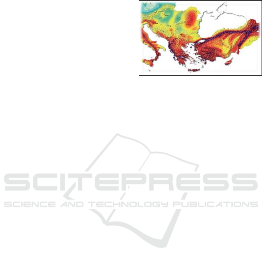
displacements. Figure 1 shows the coverage of the
Mediterranean seismic zone with a fragment of the
map showing the risk of seismic activity in Europe.
Bulgaria has registered high seismic activity in
several areas. The most risky are: Kresnenska,
Plovdivska, Sofiiska, Gornooryakhovska and
Shablenska zones. The strongest earthquake had a
magnitude of 7.8 on the Richter scale and was
located in the valley of the Struma River in 1904.
The last strong earthquake was in the area of Pernik
on 22.05.2012 with a magnitude of 5.8 on the
Richter scale near Sofia and was felt by most of its
residents. The last stronger earthquake in Bulgaria
was in 2012 with a magnitude Mw of 5.6 near the
capital Sofia (Solakov D. et al., 2018b).
The last event that shook the whole world was the
earthquake doublet on February 6, 2023. in southern
Turkey near the northern border of Syria with
magnitude M 7.8, which was followed later by an
event with magnitude M 7.5 at about 90 km north of
the first. The location of the first earthquake is near
the triple junction of the Arabian and African plates
and the Anatolian block. In scientific community it is
widely accepted that seismicity in Turkey is due to
the relative movement of three large tectonic plates
(Arabian, Eurasian and African), as well as one
smaller tectonic block (Anatolian).
The geological development of the region is the
result of several boundary interactions between these
plates, which include subduction, large scale
faulting, compressional mountain uplift, and
extension of the Earth's crust. When the African and
Arabian plates converge the Eurasian plate leads to
the closure of the Mediterranean Sea and at the same
time is the reason for the westward movement of the
Anatolian block.
Figure 1: The Mediterranean Seismic Zone.
This movement is taking place mainly along the
fault lines on the two Anatolian fault lines –
Northern and Eastern. (Kalafat et al., 2021) The
westward movement of the Anatolian block is
mainly carried out by the North Anatolian fault
system evidenced by the large number of
earthquakes registered during the second half of the
last century. On the other hand, the same block
moves in a southwest direction towards the Arabian
Plate, as the movement is realized along the Eastern
Anatolian, where also earthquakes with magnitude
above 7 were recorded. Based on event from
27.01.2020 as well as other ones since the beginning
of the century it can be said that the Eastern
Anatolian fault is the more active (Utkucu M. et al.,
2023), (Reitman et al., 2023)
Co-seismic deformations of the Earth's crust
occur at the time of a strong seismic event, with a
magnitude above 5.0 on the Richter scale and have
manifestations on the Earth's surface at points near
to the epicentre of the event. They are determined
mainly by the satellite observations using
technologies based GNSS and SAR data, that was
applied successfully in the recent years.
The basic way to register and measure the
strength of an earthquake is through the use of a
seismic station, equipped with different types of
seismic receivers. In the last decade seismic stations
are supplemented by ground-based networks of
GNSS receivers, which provide the possibility to
determine displacements, occurring at the Earth's
surface and the propagation of seismic waves.
The Global Navigation Satellite System (GNSS)
is used to study the velocity field of the Earth's crust,
as well as Earth's deformations, attributed to
seismic, volcanic, geological or anthropogenic
activity. Using the GNSS method it is possible to
determine the 3D vector of displacement on the
earth's surface and calculate errors of 2–3 mm for
the horizontal and 5–8 mm respectively for the
Studying Seismic Events via Satellite Interferometry for the Territory of the Balkan Peninsula
153

vertical components confined to the position at the
point of measurement.
By processing data from Earth observation
satellites registering data with radar instruments by
DinSAR method provides greater spatial coverage,
but information about displacements is in the line-
of-sight (LoS) on the antenna. Additional analysis is
necessary to obtain all components of the Earth's
motion vector. The main sources of data that are
planned for use are the SAR products from the
Sentinel-1 mission thus achieving extensive
territorial coverage. This allows preparation of maps
that reveal the scale of deformations on the Earth's
surface. Along with these data other data for the
epicentre of earthquakes and for the established
faults in the research areas are used as well. Due to
the fact that the DInSAR method requires the
availability of two radar images obtained during a
time interval between the registrations of the SAR
data the mentioned maps reflect the cumulative
effect of all seismic events in this interval. This
means that it is not possible determine the
contribution of a single event to the produced
displacements.
2.2 Current State of the Research in
the Investigated Area
As mentioned, the Balkan Peninsula, and in
particular the territory of Bulgaria and Greece, show
active tectonics and seismicity. Currently advanced
space geodetic techniques and methods are used for
better understanding of long term geological and
geophysical processes. Based on the analysis and
processing of GNSS data, a number of studies show
the recent activity of the region and try to give a
reasonable and adequate interpretation of the
obtained results regarding the processes of
movement of the earth's crust in the region
(Burchfiel et al ., 2006), ( Burchfiel et. al., 2008),
(Georgiev et. al., 2013), (Kotzev et.al., 2006),
(Milev, Dabovski, 2006) (Matev, 2011), (Reilinger
and al., 2010), (Vassileva, Atanasova, 2014), (
Zagorchev, 2011) and others.
On July 20, 2017, an earthquake occurred near
the island of Kos with Mw 6.6 and a depth of 2 km.
The epicentre of the earthquake is located in the
Aegean Sea, about 1 km south of the uninhabited
island of Karaada and also the Greek islands of Kos
and town Bodrum with in the southwestern part of
Turkey was affected. Maps of the displacement were
created and the values of the southern time sinking
of Karaada Island in the LoS direction from
descending and ascending orbits were determined
(Atanasova § Nikolov 2018); (Atanasova § Nikolov
2019).
The surface deformations that occurred after an
earthquake on October 25, 2018 located about 45 km
southwest of the island of Zakynthos with Mw 6.8
and a depth of 10 km (Ganas et al., 2020) (Nikolov
et al., 2021) were also determined based on the
prepared interferograms. On November 26, 2019,
the most devastating earthquake in the last 40 years
for the region occurred in the north-western part of
Albania, which was the second such event in a
period of three months and was located about 8 km
northeast of the port city of Durres. The
interferometric results are presented in (Nikolov et
al., 2020) and (Nikolov et al., 2021).
The devastating earthquake that struck Croatia
on December 29, 2020 had a magnitude of 6.4 on
the Richter scale. This is the biggest earthquake in
Croatia recorded in the last century. An earthquake
of similar magnitude occurred in 1880 near Zagreb.
Three earthquakes of magnitude 6 and greater have
occurred since 1900 to date within 200 kilometres of
the epicentre of the said earthquake. The main shock
and most of the aftershocks are located on the
Petrinja Fault, which is well described in the
European Database of Seismogenic Faults (EDSF)
(Basili R et al., 2013). This phenomenon is
investigated by InSAR data and supplemented with
seismological results by using Okada method
(Dimova, Raykova 2023).
The surface deformations that occurred after an
earthquake of Mw 6.0, which occurred on March 3,
2021, 20 km northwest of Larissa, Greece were
determined. (see fig 2). Usually, using the applied
method, the total changes of the Earth’s crust are
registered for the period between two passes of the
satellites, which for the Sentinel mission (for 2021)
is a minimum of 6 days (Atanasova § Nikolov 2021)
(Atanasova et al., 2021). In the (Dimova, Raykova
2023) comparison of the results from pre-calculated
vertical (up–down) and horizontal (E–W)
displacements and the theoretical results obtained
from Okada`s model was made and good
coincidence for both of the suggested focal
echanisms for Larisa earthquake was found.
(Dimova, Raykova 2023) calculated three types of
geometry for the seismic fault near Larissa varying
the length, the width and the slip over the fault.
GISTAM 2024 - 10th International Conference on Geographical Information Systems Theory, Applications and Management
154
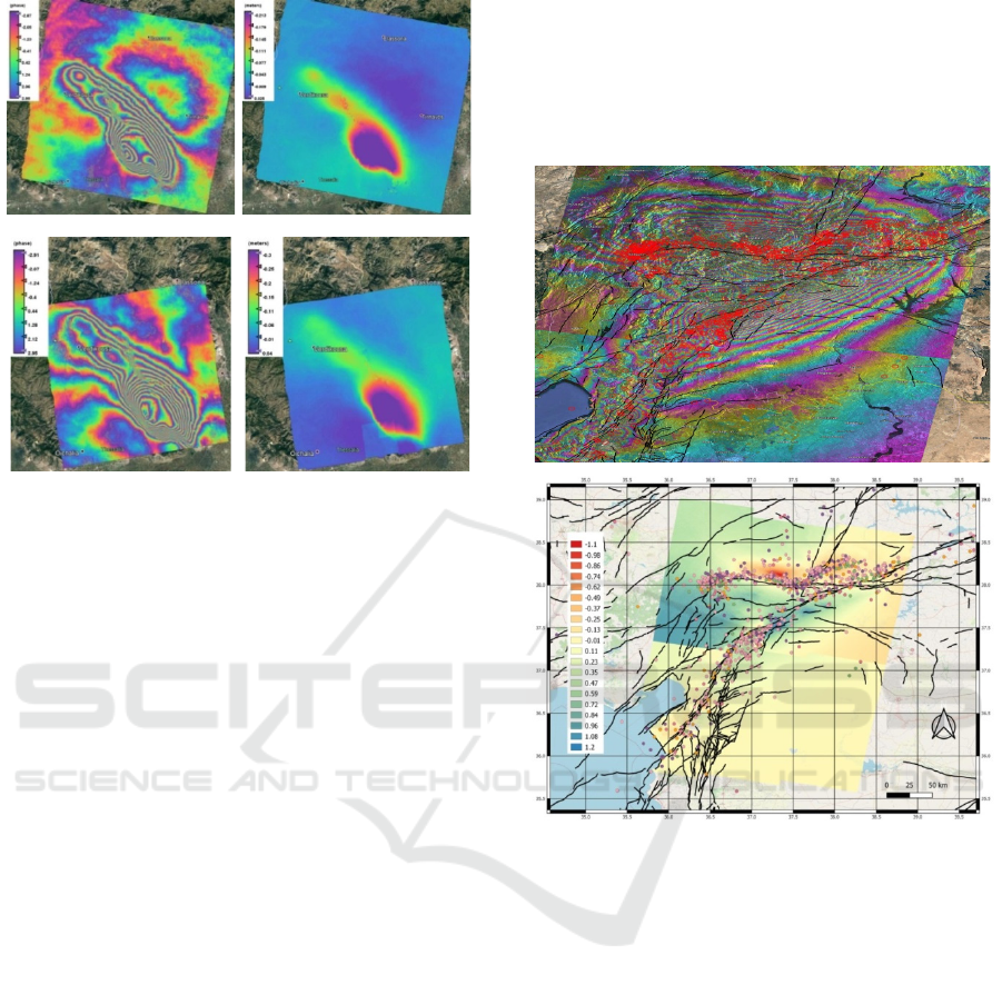
Descending orbits 80 orbit 02-14 March 2021
Ascendin
g
orbits 175 orbit 02-14 March 2021
Figure 2: Interferometric images of the area of the Larissa
earthquake and maps of the deformations along the LoS
direction determined by the two types of orbits.
The area covered by the displacements is quite
similar, although the Okada model underestimates a
little the values obtained by the DInSAR procedure.
It can be due to the uncertainties of the input
parameters used in the theoretical computation of the
displacement as well as the simplifications of the
Okada’s model.
The latest presented results obtained as a result
of the processing of SAR data, based on which
movements of the Earth’s surface caused by the
series of earthquakes that occurred in the border
region between Turkey and Syria were detected. The
latest challenge is to determine the deformations of
the wide areas, following the two devastating
earthquakes of magnitude M 7.8 and M 7.5 on
February 6, 2023. The earthquakes occurred in the
East Anatolian Fault Zone, west of Gaziantep,
Turkey.
The earthquake was followed by intense
aftershocks, the effect of which was proven after
interferometric processing of SAR data from the
European Space Agency's Sentinel-1 mission and
revealed the size of the affected area and the
magnitude of the deformations that occurred after
the earthquakes.
The maps created are combined data from
several sources: event epicenters from EMSC and
active faults from EDAF (Basili R.,, et al., 2013)
both considered to be the driving forces of ground
motions. SAR data, used to obtain information
indicating the actual surface displacements. It should
be emphasized that the mentioned information does
not reflect the consequences of one seismic event,
but the effect of all earthquakes that occurred in the
studied region between the dates of registration by
the SAR instrument (Atanasova et al., 2023),
(Nikolov & Atanasova, 2023).
Figure 3: Interferometric images of the area of the Turkey
earthquake registering the vertical deformations by
descending orbit SAR data, earthquake area and
epicentres, active faults.
3 OBJECTIVES AND
HYPOTHESES FOR
DEVELOPMENT OF THE
PROJECT
The purpose of this study is the regular monitoring
of seismic deformations of the Earth’s crust using
innovative methods. The main task is to demonstrate
operational readiness to determine the magnitude of
the deformations of the Earth’s surface, the size of
the affected areas and to prepare maps of the
displacements that have occurred. This goal will be
achieved through the creation and realization of a
methodology for extracting high-quality information
from SAR products aimed at continuous monitoring
Studying Seismic Events via Satellite Interferometry for the Territory of the Balkan Peninsula
155

of areas that could be considered as potential foci of
strong earthquakes, integrating interferometric
images (IFI) and GNSS data. As a result, a working
prototype of an information system for monitoring
and prevention of the consequences of co-seismic
deformation of the Earth’s crust (landslides,
collapses, etc.) based on freely available data
provided by ESA and national sources will be
created.
Achievement of the set goal is realized through
interrelated and complementary scientific and
scientific-applied tasks:
– Creation of a catalogue with earthquakes in the
Balkan Peninsula having magnitude of 5.0 or
more Mw
– Creation of automated methodology for
extraction of data from SAR and their unified
processing for geocoding.
– Obtaining the coordinates and speeds of the
permanent GNSS stations coordinates and
velocity of permanent GNSC stations from the
national network of NIGGG and freely available
data from other types of GNSS stations for the
territory of the Balkan Peninsula.
– Analysis of GNSS time series to register changes
(jumps) due to seismic events
– Determination of the deformations of the Earth’s
crust by the method of Okada on geophysical and
seismic data and their comparison with the
results obtained from the SAR data
– Formation of a data base for the investigated
areas , including IFI , geodetic data from
permanent stations, seismic and geophysical
data, as well as carrying out spatial analysis
regarding the presence of deformational
processes ;
– Determining the possibility of searching for a
connection between the location of the epicentre
of an earthquake and the tectonics of the research
area, lithospheric plates and the possibility of
predicting the occurrence of an event based on
changes in the magnetic field or other
geophysical factors.
After the implementation of the above
formulated tasks, it will be reached the fulfilment of
the second goal of presenting the information system
not only among the scientific community, but also
before the national and local authorities, the
academic community and other interested parties. In
this way we hope to give them the opportunity to use
a new tool to solve the problem before it occurs on a
specific disaster of natural or anthropogenic
character.
One of the scientific tasks envisaged to be solved
include the development of methodological
approaches for the comparison of the results of the
joint processing of interferometric images from the
SAR, the data from the permanent GNSS stations
and the obtained results for the deformations of the
Earth’s crust by Okada's method on geophysical and
seismic data.
After the primary processing of the three types of
data, their fusion and subsequent spatial analysis in a
GIS environment is foreseen. In this way, the degree
of preparedness of national and local authorities, as
well as society as a whole, will be increased, the
prevention will improve and the consequences of
this kind of disasters overcomed.
4 METHODS, RESEARCH
EQUIPMENT AND
TECHNIQUES
4.1 Global Navigation Satellite Systems
Global navigation satellite systems (GNSS) consist
of a ground network of receivers, space and control
segments. The use of GNSS for seismic monitoring
in Bulgaria and the Balkans has great potential,
using data from GNSS networks with free access
such as: international- ITRF, IGS; Regional - EPN
on EUREF; National GNSS network.
Registration of seismic movements of the Earth's
crust on the territory of Bulgaria on the basis of data
received from permanent GNSS networks can be
used for operational seismic monitoring and
supplementing information related to the occurrence
and tracking of events, thus delivering information
on the Earth's crust movements at Balkan Peninsula.
In the present project it is anticipated to use the data
from the National Geodetic Network, maintained by
NIGGG-BAS.
4.2 Bulgarian Seismological Network
NIGGG-BAS runs the Bulgarian seismological
network-NOTSSI (National Operative Telemetric
System for Seismological Information). NOTSSI
was founded at the end of 1980. The network
comprises today 17 permanent seismic stations and
two local networks. In 2005 the modernization of the
seismological network was performed. The overall
objective for the NOTSSI is continuous monitoring
of seismicity on the territory of Bulgaria and
adjacent areas within the Balkan region. After the
GISTAM 2024 - 10th International Conference on Geographical Information Systems Theory, Applications and Management
156
modernization, NOTSSI became a world-class
digital network providing reliable, real-time seismic
monitoring and rapid earthquake information to both
scientific communities and authorities in Bulgaria
for seismic risk mitigation. Recently developed
Methodology for analysis, assessment and mapping
of the seismic risk of Bulgaria; and the new seismic
hazard assessment for Bulgaria are based on the high
quality seismological information.
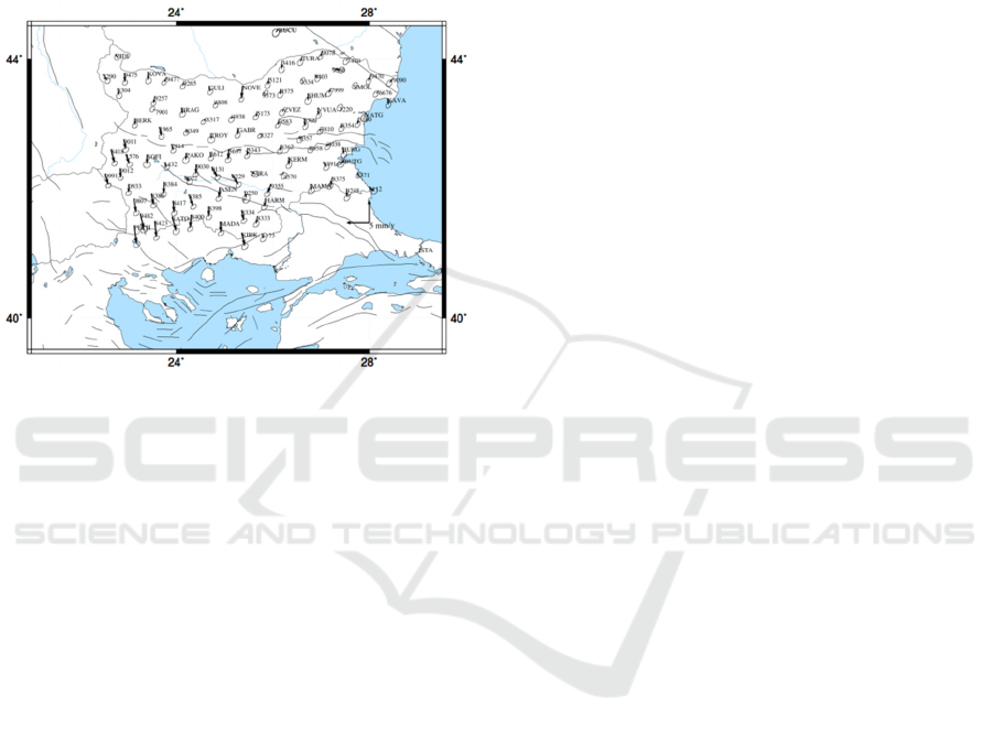
Figure 4: The horizontal velocities of the points of the
Basic class of the State GPS network - 2014-
2018.
https://ngic.bg/.
The area subject to research in the proposed project
covers the Balkan Peninsula, which justifies the
need for additional GPS/GNSS infrastructure in it,
since successful monitoring of modern crustal
movements implies: permanent stations with
sufficient density and GNSS points.
4.3 Differential Interferometry
Differential interferometry (DinSAR) is a method
for processing radar data from synthesized aperture,
derived from remote Earth observation, that can be
used to quantify small displacements on the surface.
For example, using data from the Sentinel-1 satellite
and applying DInSAR, mapping of topography over
a large area or registration of movements on the
Earth's surface is performed. The DInSAR method is
based on using two images of the phase signal
backscattered from the Earth's surface obtained for
the same region at different times. In processing the
SAR data, co-registration of the two SAR images is
performed and then a differential interferogram is
generated, which shows the magnitude of the
deformation using the change in the phase signal.
The horizontal and vertical movements are
registered in LoS vector that needs to be
decomposed. At the stage of formation of the
interferogram a digital terrain model (DEM) with a
resolution of 1 arcsec is used, since it is essential
that the spatial resolution of the final interferometric
image (IFI) be as high as possible.
4.4 Okada's Method
The surface displacement, due to the elastic
deformations of the earth's crust, after generated
earthquake was obtained as an analytical solution of
Okada's formulas (Okada, 1985, 1992).
The co-seismic deformation is calculated as a
function of the geometrical parameters of the fault
and the elastic properties of the medium. The
geometry of the modelled faults was calculated
using the formulas of Mai and Beroza (2000) for the
relationship between the seismic moment of a given
earthquake and its magnitude.
4.5 GIS Data
Initially, a register will be created of all registered
earthquakes with a magnitude above 5.0 in the last
eight years (after 2015) for the Balkan region and
neighboring territories. This database will continue
to be populated throughout the duration of the
project. Based on it, the location and time interval of
the seismic event will be identified, which will make
it possible to proceed to the creation of the
specialized archive with SAR data.
Here, additional terrain elevation data will be
required, so DEM data must be available from
external sources, such as SRTM or ASTER
repositories, and must be included in the local
archive already created. After that, it is planned to
integrate the IFI and GNSS data from the
geodynamic network. Here, both data types must be
in the same coordinate reference system and
projection.
Based on this, we will prepare displacements maps
in GIS layers for the Balkan region in a time interval
of 6 or 12 days, based only on IFI, which will allow
us to obtain the movements that occurred during the
earthquakes.
5 CONCLUSIONS
The purpose of the project is formulated on the basis
of previous scientific and scientific applied research
on the team. The implementation of the project will
help to increase the quantity and quality of
fundamental scientific research related to problems
Studying Seismic Events via Satellite Interferometry for the Territory of the Balkan Peninsula
157

of regional and national importance. The tasks of the
project include both the intensification of the
relationship between science and education and
society as a whole and the enhancement of the
quantity and quality of the internationally visible
scientific output.
The public challenges to which the project is
focused are minimizing the damages from natural
disasters and accidents and for protecting the
environment. The project also responds to them by
studying geodynamic processes in the Earth's crust
and providing up-to-date information about them.
ACKNOWLEDGEMENTS
This study was supported by the Contract № KP-06-
N74/2 from 14.12.2023, (project “Study of co-
seismic deformations of the earth's crust for the
territory of the Balkan Peninsula based on satellite
data” financed by Competition for financial support
of basic research projects – 2023.
The authors would like to express their gratitude
to European Space Agency for providing Sentinel-1
SAR data and processing software SNAP at no cost.
REFERENCES
Atanasova M., Nikolov H., Protopopova V., (2018)
Determining the deformations of the earth's crust after
an earthquake using DInSAR. IX National Conference
on Geophysics - CD, 2018, ISSN:1314-2518 (in
Bulgarian)
Atanasova M., Nikolov H., Protopopova V., (2019).
DInSAR in displacement detection after seismic
events. Proceeding 10th Congress of Balkan
Geophysical Society, 18-22 September 2019, Albena
Resort, Bulgaria, EAGE, 2019, DOI: 10.3997/2214-
4609.201902642, 1-4. SJR (Scopus):0.11
Atanasova Mila, Nikolov H., (2021) Determining the
deformations of the earth's crust using DInSAR that
occurred after the earthquake in the Larisa region of
March 3, 2021. 10TH NATIONAL CONFERENCE ON
GEOPHYSICS / National Institute of Geophysics,
Geodesy and Geography, BA Sofia, CD 10, X, Society
of Geophysicists in Bulgaria, 2021, ISSN:1314-2518,
1-8, (in Bulgarian) https://www.niggg-bas.com/
periodicals/x-national-geophysical-conference-4th-
june-2021/n3/
Atanasova Mila, Nikolov Hristo, (2022) A STUDY OF
SEISMIC DISPLACEMENTS IN THE BALKANS
FROM SATELLITE DATA, Proceeding XXX
International symposium on modern technologies,
education and professional practice in geodesy and
related fields, Sofia, 02 – 04 November 2022
ISSN:2367-6051, 1-11
Atanasova M., Nikolov H., Oynakov E. (2021) Co-
Seismic Surface Displacements After The Earthquakes
In Larissa, 3 March 2021, Derived By Dinsar.
Proceedings of 21th International Multidisciplinary
Scientific GeoConference SGEM 2021, Volume: 21,
Book number: 2.1, International Multidisciplinary
Scientific Geoconference, 2021, ISBN:1314-2704,
ISSN:978-619-7603-22-4,
DOI:10.5593/sgem2021/2.1/s10.64, 521-528.
Atanasova M, Raykova P, Nikolov H., (2023)
Determining the Deformations of the Earth's Surface
after the Earthquakes in Turkey-Syria of 06 February
2023 - Initial Results. Comptes rendus de l’Académie
bulgare des Sciences, 76, 4, Bulgarian Academy of
Sciences, 2023, ISSN:1310–1331, DOI:https://doi.org/
10.7546/CRABS.2023.04.07, 554-562
Atanasova Mila. (2023) Determination of coseismic
deformations in the Balkan Peninsula area based on
SAR data. XI National Geophysical Conference, 9th
June 2023. Proceedings of the XI National
Geophysical Conference, 9th June 2023., XI, NIGGG-
BAS, CD, 2023, DOI: https://doi.org/10.48368/BGS-
2023.1.N12 (in Bulgarian)
Basili R., V. Kastelic, M. B. Demircioglu, D. Garcia
Moreno, E. S.Nemser et al. (2013) The European
Database of Seismogenic Faults (EDSF) compiled in
the framework of the Project SHARE,
https://doi.org/10.6092/INGV. IT-SHARE-EDSF.
Burchfiel, B.C., King, R.W., Todosov, A., Kotzev, V.,
Durmurdzanov, N., Serafimovski, T., Nurce, B. (2006)
GPS results for Macedonia and its importance for the
tectonics of the Southern Balkan extensional regime.
Tectonophysics, 413, 239-248
Burchfiel, B.C., Nakov, R., Dumurdzanov, N.,
Papanikolaou, D., Tzankov, T., Serafimovski, T.,
King, R.W., Kotzev, V., Todosov, A., Nurce, B.
(2008) Evolution and dynamics of the Cenozoic
tectonics of the South Balkan extensional system.
Geosphere, 4, 919-938, doi:10.1130/GES00169.1 1.
Copernicus. Sentinel-1 data 2017 to 2021. Retrieved from
ASF DAAC (8 Nov 2019), Processed by ESA.
Available online: https://asf.alaska.edu/ (accessed on
May 2021).
Dimova, L. R. Raykova. (2023) Complex analysis of
earthquake deformations using SAR images:
Examples from Croatia and Greece. Journal of
Physics: Conference Series (JPCS). 2668(1):012011,
DOI: 10.1088/1742-6596/2668/1/012011
Ganas, А., P. Briole, G. Bozionelos, A. Barberopoulou, P.
Elias, V. Tsironi, S. Valkaniotis, A. Moshou, I.
Mintourakis, (2020) The 25 October 2018 Mw = 6.7
Zakynthos earthquake (Ionian Sea, Greece): A low-
angle fault model based on GNSS data, relocated
seismicity, small tsunami and implications for the
seismic hazard in the west Hellenic Arc, Journal of
Geodynamics, 137, 2020
Georgiev, I., Dimitrov, D. and Botev, E. (2013) Crustal
Motion Monitoring in Bulgaria and Surrounding
GISTAM 2024 - 10th International Conference on Geographical Information Systems Theory, Applications and Management
158

Regions by Permanent GPS Array. Proceedings of 7th
Congress of Balkan Geophysical Society, Tirana,
Albania, 7-10 October 2013, 5
Kalafat D., A. C. Zülfikar and S. Okuyan Akcan (2021)
Seismicity of Turkey and Real-Time Seismology
Applications in Determining Earthquake Hazard,
Academic Platform Journal of Natural Hazards and
Disaster Management, vol. 2, no. 2, pp. 96-111, Dec.
2021, doi:10.52114/apjhad.1039670
Kotzev, V., Nakov, R., Georgiev, Tz., Burchfiel, B.C.,
King, R.W. (2006) Crustal motion and strain
accumulation in western Bulgaria. Tectonophysics,
413, 127-145.
Mai, P. M., Beroza, G. C., (2000), Source scaling
properties from finite-fault-rupture models, Bull.
Seismol. Soc. Am., 90, 3, 604-615.
Matev, K. (2011) GPS constrains on current tectonics of
southwest Bulgaria, northern Greece and Albania.
Thesis, Doctor of university of Grenoble, 203.
Milev, G. and Dabovski, C. (Eds) (2006) Geodynamics оf
the Balkan Peninsula, Monograph, Reports on
Geodesy. Warsaw University of Technology, Institute
of Geodesy and Geodetic Astronomy, 647.
Nikolov H., Atanasova M., Protopopova V.,(2021).
Application of satellite SAR data to detect
deformations of the Earth's crust after earthquakes.
Proceedings of 2nd National Workshop with
International Participation on COPERNICUS, S, pace
Research and Technology Institute - Bulgarian
Academy of Sciences (SRTI-BAS), Sofia, Bulgaria,
2021, DOI:10.5281/zenodo.6497513, 25-37
Nikolov H., Valentina P., Atanasova M.(2020) Studying
seismic events via satellite interferometry.
Proceedings Volume 11524, Eighth International
Conference on Remote Sensing and Geoinformation of
the Environment (RSCy2020); Paphos, Cyprus,
15241B, 11524, SPIE 2020, Proceedings of SPIE -
The International Society for Optical Engineering,
2020, 11524, 115241B, 2020, ISBN:978-151063857-
0, ISSN:0277786X, DOI:10.1117/12.2570676, 1-16.
Nikolov, H., & Atanasova, M. (2023). Co-seismic ground
motions from earthquakes in Turkey-Syria as
registered by SAR data. XI National Geophysical
Conference, 9th June 2023. https://doi.org/10.48368/
BGS-2023.1.N11 (in Bulgarian)
Okada, Y., 1985, Surface deformation due to shear and
tensile faults in a half-space, Bull. Seismol. Soc. Am.,
75, 4, 1135-1154.
Okada, Y., 1992, Internal deformation due to shear and
tensile faults in a half-space, Bull. Seismol. Soc. Am.,
82, 2, 1018-1040.
Solakov, DSimeonova. S., Raykova P., Aleksandrova I
(2018a). Empirical Relations Converting Md and Mp
Magnitudes Applied In Bulgarian Seismological
Routine Practice To Moment Magnitude. Comptes
rendus de l’Acad´emie bulgare des Sciences, 71, 8,
DOI:10.7546/CRABS.2018.08.09, 1076-1085
Solakov, D., Simeonova, S., Raykova, P., Aleksandrova, I
(2018b). Seismological analysis of the low frequencies
Mw5.6 earthquake in Sofia Seismogenic zone. Procc.
9th International INQUA Meeting on
Paleoseismology, Active Tectonics and
Archeoseismology, PATA, 267-270.
Reilinger, R., McClusky, S., Paradissis, D., Ergintav, S.
and Vernant, Ph.(2010) Geodetic constraints on the
tectonic evolution of the Aegean region and strain
accumulation along the Hellenic subduction zone.
Tectonophysics, 488, 22-30.
Reitman N, еt al., (2023) Preliminary fault rupture
mapping of the 2023 M7.8 and M7.5 Türkiye
Earthquakes. DOI: https://doi.org/10.5066/P985I7U2
Utkucu M. Et al., A preliminary report on the 2023
Gaziantep (Mw=7.7) and Elbistan (Mw=7.5),
earthquakes in Southeast Türkiye, February 2023, doi:
10.13140/RG.2.2.17088.40963
Vassileva, K. and Atanasova, M. (2014) Study of
transition boundaries in Bulgaria from GPS.
International symposium on modern technologies,
education and professional practice in geodesy and
related fields, Sofia, 06-07 November, 2014, 8.
Zagorchev, I. (2011) Cenozoic Block Rotations in the
Balkan Peninsula. Proceedings of 3rd nternational
Symposium of the Black Sea region, 1-10 October,
2011, Bucharest, Romania, 220-222
https://scihub.copernicus.eu/
http://step.esa.int/main/toolboxes/snap/
https://storymaps.arcgis.com/stories/355bfc8b3c5941e683
d4f258e8fb2dfa
Studying Seismic Events via Satellite Interferometry for the Territory of the Balkan Peninsula
159
