
Designing and Building a Low-Cost IoT Solution for Natural Disaster
Monitoring and Mitigation: An Experience Report
Anselmo P. R. Costa
1,3 a
, Claudia L. R. Motta
2,3 b
and Daniel Schneider
2,3 c
1
Polytechnic Institute UFRJ - Macaé, Rio de Janeiro, Brazil
2
Tércio Pacitti Institute of Computer Applications and Research, NCE/UFRJ, Rio de Janeiro, Brazil
3
Postgraduate Program in Informatics, PPGI/UFRJ, Rio de Janeiro, Brazil
Keywords: Low-Cost IoT System, Natural Disaster Monitoring, Crowdsourcing, Design Science, Problem-Based
Learning.
Abstract: Mitigating natural disasters is a global concern and a social challenge, and new technologies and social
inclusion mechanisms have been applied to improve prevention and response to these events. Several
initiatives seek to mitigate natural disasters and rely on technologies such as the Internet of Things,
crowdsourcing, volunteer training, society involvement, among others. Although there are many initiatives in
this regard, building a model enabling real mitigation of natural disasters remains a major challenge. This
study aims to present a Natural Disaster Mitigation model, which combines different technologies through
the construction of a multidisciplinary group composed of researchers, students, civil defense technicians, and
the municipal school network. The goal is to develop and implement a meteorological monitoring network
using low-cost technological artifacts installed in school systems in the target cities.
1 INTRODUCTION
Digital technologies like the Internet of Things (IoT)
and environmental education have been explored to
improve prevention and response to natural disasters.
However, to the best of our knowledge, no proposals
were found in the literature leveraging such a myriad
of strategies and technologies like Project-Based
Learning (PBL), IoT, crowdsourcing, meteorological
education, and environmental education, applied in
the context of protection and defense actions.
The goal of this work is to present a natural
disaster mitigation model that combines the
construction of IT artifacts with training for the public
involved. The idea is to build a set of low-cost
meteorological stations leveraging IoT technology,
crowdsourcing, robotics training, notions of
meteorology, and civil defense techniques. The
proposed model was prototyped and implemented by
an interdisciplinary group made up of researchers and
students from four universities, civil defense
technicians, and a group of teachers and students from
a
https://orcid.org/0000-0002-9041-3989
b
https://orcid.org/0000-0002-4069-1462
c
https://orcid.org/0000-0003-2987-4732
schools in the municipal education network, using the
PBL strategy and the Design Science Research (DSR)
method. This paper also describes the methodology
used to build and implement the proposed model, the
actions taken, and the applied technology, in addition
to presenting the results achieved so far and future
works.
This article is organized as follows. Section II
presents the theoretical foundation of digital
technologies and strategies applied in disaster
mitigation. Section III depicts the related works, and
Section IV describes the proposed model. Section V
presents the conclusions, and section VI describes our
future work.
2 BACKGROUND
Emerging technologies like IoT have been explored
to improve prevention and response to these events.
The literature highlights the importance of using the
crowdsourcing strategy in collecting voluntary
Costa, A., Motta, C. and Schneider, D.
Designing and Building a Low-Cost IoT Solution for Natural Disaster Monitoring and Mitigation: An Experience Report.
DOI: 10.5220/0012703900003690
Paper published under CC license (CC BY-NC-ND 4.0)
In Proceedings of the 26th International Conference on Enterprise Information Systems (ICEIS 2024) - Volume 1, pages 1005-1012
ISBN: 978-989-758-692-7; ISSN: 2184-4992
Proceedings Copyright © 2024 by SCITEPRESS – Science and Technology Publications, Lda.
1005

geographic information to better understand natural
disasters (Tulloch, 2014), especially leveraging the
participatory sensing paradigm (Oliveira et al., 2015).
Furthermore, studies have analyzed socio-
environmental vulnerability and disaster risk
reduction, recognizing that natural threats are not
unexpected events and that preparation is essential
(Freitas et al., 2012). The analysis of the situation of
natural disasters in Brazil has also been the subject of
study, highlighting the need to understand the
interactions between natural disasters and public
health (Freitas et al., 2014).
Literature reviews on natural disaster information
and surveillance systems are relevant to
understanding how technologies can be applied in this
context (Sobral et al., 2010). Studies have sought to
help plan preventive and mitigating actions, as in the
case of meteorological diagnosis of natural disasters
(Barcellos et al., 2016).
On the other hand, the theoretical analysis of
natural disasters has been explored in several areas of
knowledge, emphasizing the importance of risk and
disaster management due to the increase in the
magnitude and frequency of these events (Machado
& Machado, 2019; Kobiyama et al., 2018). The use
of IoT technologies for humanitarian logistics and for
search and rescue in natural disasters has also been
the subject of a literature review (Monteiro et al.,
2018). Vulnerability to natural disasters and their
nursing implications have also been addressed,
highlighting the importance of preparation to face
these events (Bandeira et al., 2014).
Meteorological monitoring in Brazilian cities is
carried out through a network of meteorological
stations distributed throughout the country. These
stations collect data on atmospheric conditions, such
as temperature, air humidity, atmospheric pressure,
wind speed, and direction, among other
meteorological parameters. The main institution
responsible for this monitoring in Brazil is the
National Institute of Meteorology (INMET), which is
linked to the Ministry of Agriculture, Livestock and
Food Supply.
INMET operates an extensive network of
automatic and conventional meteorological stations
located in urban and rural areas. Automatic stations
collect data continuously and in real time,
transmitting the information to processing centers. In
addition, there are conventional stations where human
observers manually record meteorological data. In
addition to INMET, other institutions, such as
universities and research centers, also contribute to
meteorological monitoring in Brazil. The information
collected is used to produce weather forecasts,
weather alerts, and climate studies, providing data for
various areas, such as agriculture, aviation, water
resources management, and natural disaster
prevention (INMET. 2024).
Considering INMET's limited resources and the
country’s territorial extension, the involvement of
various institutions and the very civil society through
transversal, collaborative and low-cost alternatives is
crucial, aiming to address the challenges related to
meteorological monitoring. One of these alternatives
lies in the proposal of a natural disaster mitigation
model leveraging IoT technology and crowdsourcing,
with the use of low-cost meteorological sensors,
cloud applications with various collaborative
resources, and the direct involvement of the school
community and its surroundings, supported by the
offer of robotics courses, notions of meteorology and
civil defense. With this methodology, microregions
can be equipped with low-cost stations, and a clear
picture of the meteorological response can be
obtained.
Regarding the inclusion of crowdsourcing in our
mitigation model, we were inspired by the work of
Chaves et al. (2019), who highlight that citizen
involvement has been increasingly used in the
prevention and management of urban disasters, in
addition to the fact that current networked citizens are
in direct contact with institutions and companies
(Schneider and de Souza, 2015). This scenario thus
creates a unique opportunity to leverage the work of
crowd volunteers.
3 RELATED WORK
An example that uses the DSR approach and values
integrating IoT resources with education is presented
by Costa et al. (2022). It describes a proposal to
integrate IoT concepts and technologies into the
curriculum of a high school technical course in
Agriculture, using a technological artifact based on
IoT as a teaching tool. In an evaluation with course
teachers, interest in applying the proposal and the
great potential of the artifact for improving teaching-
learning processes was demonstrated.
Several works seek to mitigate natural disasters
using software and hardware artifacts. Simoes and De
Souza (2016) demonstrate technologies for
implementing low-cost stations using the MQTT
protocol and the ESP8266 microcontroller. On the
other hand, Math and Dharwadkar (2018) propose a
cloud-based intelligent system weather station. The
storage and processing of data obtained to predict the
effect of climate change is done in the cloud, and the
ICEIS 2024 - 26th International Conference on Enterprise Information Systems
1006

system is designed to effectively monitor
environmental weather conditions such as
temperature, humidity, wind speed, pressure and
precipitation. The authors aimed to design a low-cost
system requiring less maintenance and minimal
human intervention.
Kodali and Mandal (2016) present the way in
which a weather station can be described as an
instrument or device that provides us with
information about the weather in our neighboring
environment. The authors also show how it can
provide details about ambient temperature,
barometric pressure, humidity, etc. Therefore, this
device basically detects temperature, pressure,
humidity, light intensity and rainfall amount. They
further describe that several types of sensors are
present in the prototype, through which all the
aforementioned parameters can be measured. With
the help of temperature and humidity, we can
calculate other data parameters such as dew point.
In addition to the resources mentioned above, the
study presents the possibility of monitoring the light
intensity of the location, the atmospheric pressure in
the room, and the amount of rain. The core of the
presented prototype is the Nodemcu (12E) WiFi
module based on ESP8266 with connected sensors.
Such sensors are parameterized so that whenever
values exceed a chosen limit, warnings are sent via
email and a tweet alerting the device owner to take
the necessary measures.
Banara, Singh and Chauhan (2022) present a
bibliographical review of an existing meteorological
monitoring system, including its sensors,
microcontrollers, and means of communication. The
chronological review of meteorological monitoring
system literature presented by the authors provides a
chronological table with publication date, sensors
used, parameters used, description, and platform used
of fourteen studies.
As previously stated, in the literature, we did not
find a model similar to the one proposed by this study,
where it was decided to: a) combine the competence
of researchers and university students in a set of
activities that involved different actors in the
mitigation control process; b) bring the municipal
school network into the mitigation control process; c)
implement meteorological stations in schools; d)
include in the project a teaching and training model
(for teachers, technicians, students and volunteers
involved) addressing fundamental concepts related to
the problem of mitigating natural disasters as well as
notions of meteorology and civil defense.
4 PROPOSED MODEL
The methodology used in this work was DSR because
it aims to build innovative artifacts proposed to solve
real societal problems based on the production of
scientific knowledge (Dresch et al., 2015). The DSR
process is divided into highly interconnected steps
that may overlap, allowing the results of some steps
to influence the review of a previous step.
Development in cycles allows new functionalities to
be developed and integrated into previous cycles,
according to the evaluation of the results (Goecks et
al., 2021).
DSR begins with the stages of identification and
awareness of the problem, where the possibility of
integrating universities, civil defense and municipal
school networks through a disaster mitigation model
was discussed. The goal is to reduce the effects of
natural disasters and build more participatory,
resilient societies with a preventive culture.
From the problems encountered to the final
proposal of the model, collective intelligence
concepts were used both in generating ideas and in
decision support, enabling the aggregation of
information, decision-making, the improvement of
scientific practice, and work management (Pentland,
2006). Initially, the model was proposed to include
only a couple of actors, emphasizing developing a
station prototype and the necessary tools for data
collection and analysis. However, it became clear that
building such a model would require more actors,
with a structure being built that encompassed several
entities acting through an iterative DSR process.
Although the goal of the proposed model was to
serve the school networks of the target cities, it was
crucial to give the starting point by building a pilot
project. This paper describes the first pilot application
of our natural disaster mitigation model, designed for
the city of Macaé, in the state of Rio de Janeiro,
Brazil. Several activities were carried out
collaboratively using an iterative DSR process to
develop and implement this network of stations.
Figure 1 depicts the core of our proposed model,
showing key tasks covering the various entities
involved.
● Creation of a multidisciplinary working group
involving students and researchers from four
higher education institutions with Educational
management, Hardware Development Team,
Software Development Team, Marketing Team,
Robotics Training Team, BI Data Analysis
Training Team, Deployment Team, Management
and quality team;
Designing and Building a Low-Cost IoT Solution for Natural Disaster Monitoring and Mitigation: An Experience Report
1007
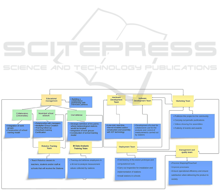
● Strategic definition of the points where
meteorological stations would be located;
● Low-cost, real-time, Internet-enabled station
construction/assembly with IOT technology;
● Development of a tool for collaborative use for the
analysis and control of measurements carried out
by stations;
● Field testing of the station prototype and
computational tools;
● Building a collaborative partnership with
interested parties, including Macaé City Hall –
(Secretary of education and civil defense), the
Universidade Norte Fluminense (UENF) through
its meteorology laboratory (LAMET)
● Development of a relationship with the municipal
school network providing robotics training for
staff and students (construction of a
meteorological station), notions of meteorology
and notions of civil defense;
● Training civil defense employees in a BI tool to
analyze data collected by stations.
Before understanding the process, we describe the
entities involved and their relationships (Figure 1).
4.1 Multidisciplinary Working Group
A multidisciplinary group was created with
researchers and students from different courses from
four higher education institutions distributed in
teams, as shown in Figure 3.
The courses involved were Mechanical
Engineering, Production Engineering, Pharmacy,
Nutrition, Chemistry, Medicine, Information
Systems, Mathematics, Electrical Engineering and
Meteorological Engineering. The purpose was to use
free robotics with the application of active
methodologies in solving and testing practical
problems (PBL), seeking to contribute significantly
to the improvement of learning, in addition to
enabling the construction of robotic devices that assist
in the learning process and construction of
knowledge. Integrating the university with partner
institutions will allow it to respond to social,
environmental, and organizational challenges in the
context of the continued training of professionals in
the school network and civil defense.
4.2 Strategic Definition of
Meteorological Stations
Macaé is located at latitude S -22º22'33" and
longitude W -41º46'30", with 23 kilometers of
coastline. The climate is hot and humid most of the
year, with temperatures varying between 18ºC and
30ºC, with considerable thermal amplitude caused
due to the exchange of winds between the coast and
the mountains, which are relatively close. The schools
were defined through a study carried out by civil
defense looking for important areas for
meteorological studies or vulnerable to natural
disasters, taking into account that the city has
characteristics of mountains and sea. The school
community plays a fundamental role in the model, as
it functions as a center for collecting and
disseminating information.
Figure 1: Relationship of the entities that comprise the process (multidisciplinary working group).
ICEIS 2024 - 26th International Conference on Enterprise Information Systems
1008
Teachers and students are trained to understand and
interpret a weather station’s construction mechanism
and the alerts issued by the IoT system, transforming
schools into crucial points of contact for communica-
tion with civil defense and the wider community.
Figure 2: Teams that make up the project.
4.3 Low-Cost Station Assembly with
IoT Technology
A low-cost real-time station prototype was
developed. It was crucial that the station had the
following characteristics: easy to build, weather
resistant, insectproof, lightweight, easy to install, and
sustainable. We also aimed that the sensors had the
following technical capabilities: internet-enabled,
consuming little energy, auxiliary power,
computationally efficient, easily programmable, with
over-the-air (OTA ) updates.
Figure 3: Part of the multidisciplinary group
Thinking about functionality and ease of
maintenance, which should be carried out in
partnership with teams from schools, civil defense
and employees, it was decided to build the stations in
modules, which were categorized into four groups
that include: microcontroller, circuit, sensors for
humidity, temperature, wind speed, wind direction,
rainfall volume, atmospheric pressure and auxiliary
outputs for new sensors, solar power supply and
hardware peripherals.
A prototype station was developed based on the
ESP32 microcontroller platform with Wi-Fi functio-
nality and using OTA updates. The microcontroller is
connected to a custom circuit board, as seen in Figure
4. It acts as the central location to which all electronic
and electrical components and sensors are connected,
as shown in Figure 5.
Figure 4: Weather station central.
Figure 5: Station components, including sensors.
4.4 A Tool for Collaboratively
Analyzing Measurements
The application was developed according to the needs
established by civil defense, using a set of
programming languages and technologies (such as
Designing and Building a Low-Cost IoT Solution for Natural Disaster Monitoring and Mitigation: An Experience Report
1009
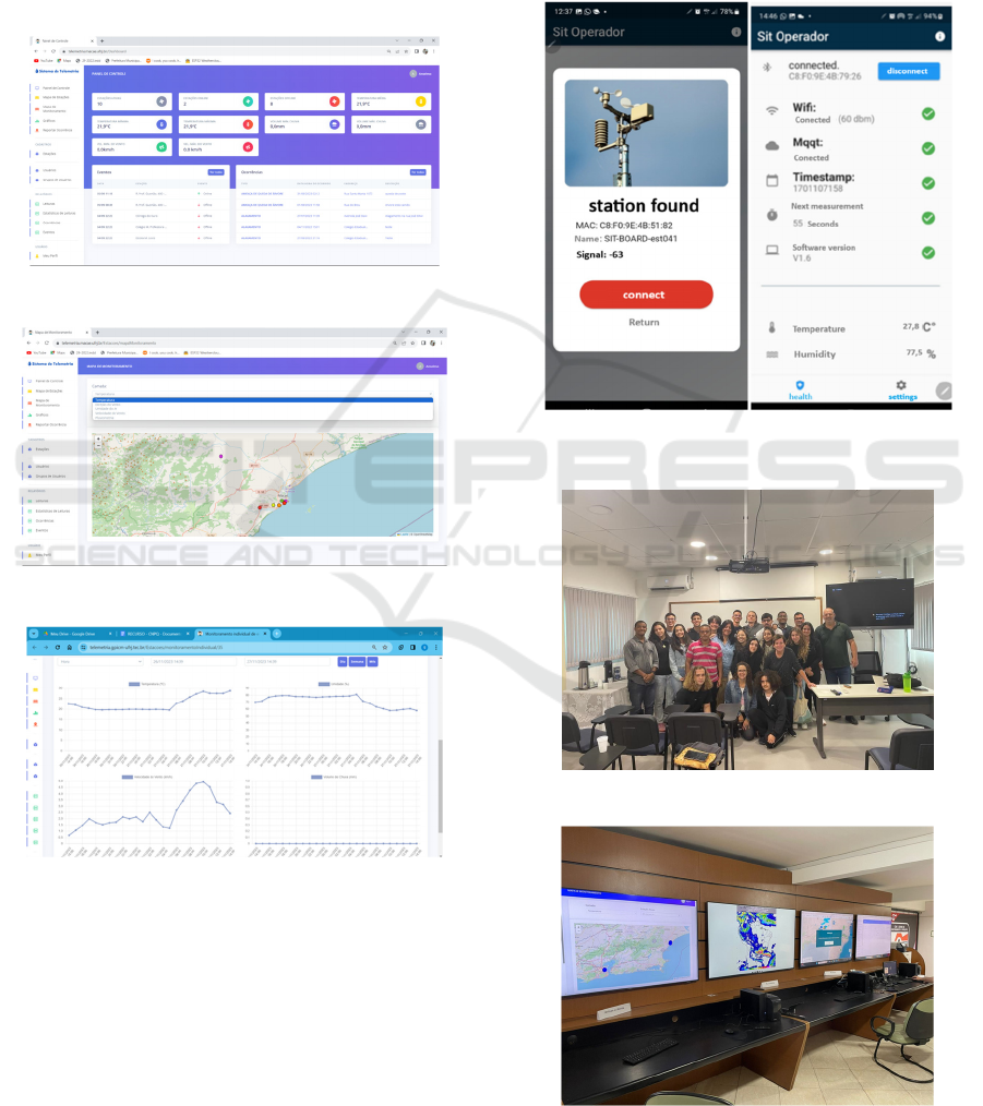
PHP, apache web server, Codeigniter framework, and
MySQL database). Figures 6-8 depict various
features of the application, such as control panel
functions displaying general statistics and event
control; visualization of station status and monitoring
with color scale on georeferencing; statistical
visualization of readings through graphs, control of
incidents throughout the city reported by users;
registrations for station management.
Figure 6: Real-time application main screen.
Figure 7: Station map screen per alert.
Figure 8: Station graphics screen.
4.5 Field Testing
After prototyping, the stations were produced and
programmed with embedded software in C language.
A service analysis and configuration tool was also
developed using Bluetooth Low Energy (BLE)
technology to facilitate the maintenance and
installation of stations in schools (Figure 9).
4.6 Collaborative Partnership
A collaborative partnership was developed with
interested parties, including Macaé City Hall (civil
defense department), municipal education
department, and UENF through its meteorology
laboratory (LAMET), where we have several
researchers and students from different courses.
Figure 9: Service analysis and configuration tool using
Bluetooth Low Energy (BLE) technology.
Figure 10: Part of the team of project collaborators.
Figure 11: Civil defense monitoring center.
ICEIS 2024 - 26th International Conference on Enterprise Information Systems
1010

Such partnership has become fundamental to building
knowledge and the feeling of belonging. A
monitoring center (Figure 11) was created to support
the analysis of collected data and civil defense
decision-making with real-time readings.
4.7 Development of a Relationship with
the School Network
The participation of school representatives in
robotics, meteorology, and civil defense courses is
essential for disseminating information and building
a sense of belonging with each station being
implemented as well as the project as a whole, aiming
to mitigate natural disaster actions.
Training in robotics, notions of meteorology, and
civil defense techniques was offered to thirty-five
schools in the municipal network. At this stage, it was
possible to serve a number of forty-nine employees
and students from sixteen schools.
In the robotics course, theoretical and practical
classes were offered with an ESP32 microcontroller
and a set of sensors, enabling the student to obtain
robotics concepts through the construction of
experiments and the development of a station similar
to the one implemented in their school. The goal was
to involve the school group in the use and
maintenance of it.
In meteorology training, relevant topics were
presented, such as the World Meteorological
Organization (WMO), global observation system,
meteorological radars, frontal systems and
extratropical cyclones, meteorological systems,
mesoscale convective complexes, extreme events,
cloud observation, how to monitor season data,
changes climate, renewable energy, weather forecast,
air pollution, climate and arboviruses.
The civil defense training was composed of
notions of civil defense, disasters and monitoring, a
set of prevention, mitigation, preparation, response
and recovery actions, national defense system,
concepts of prevention, mitigation, preparation,
response, recovery and restoration, what is a disaster,
types of disasters, Brazilian classification and coding
of disasters (cobrade), differentiating floods from
overflow, risks in flooded or overflow streets, storms
and hangovers.
4.8 Training Civil Defense Employees
in a BI Tool
The training aimed to train civil defense employees in
data analysis in order to allow the generation of
relevant information from data generated by
meteorological stations. Google Looker Studio was
used as a data analysis and business intelligence tool
emphasizing meteorological data. Training was
offered in a virtual learning environment due to the
dynamics of the technical activity of civil defense
agents. Participation in the training was voluntary and
we had significant participation, with a 65%
completion rate. Training of technicians in the
analysis of meteorological data using the Google
Looker tool was considered to be positive, where 83%
of students gave grades nine and ten after being
questioned with the following question: Considering
all aspects evaluated, globally, what grade would you
give the Course on a scale of 1 to 10?
5 CONCLUSIONS
The strategy of combining the expertise of
researchers and university students in a set of
activities that involve several actors in the mitigation
control process is neither simple nor trivial, and the
results related to the challenge of disaster mitigation
must be evaluated in a medium and long term. Part of
the challenge was to bring the municipal school
network into the mitigation control process and offer
the possibility of training in addition to implementing
meteorological stations in schools. However,
evidence of positive results has already been
collected, despite the very recent implementation of
the project, highlighting the integration of
universities, through their various courses, with the
local government and the education department.
In addition, a set of results was achieved in the
context of the project in 2023:
● Savings of 4 million Brazilian reais in
implementing a low-cost station monitoring
system.
● 16 meteorological stations installed.
● 16 schools in the municipal school network had
groups trained in robotics, meteorology
concepts and civil defense.
● Integration of 42 students from 4 universities in
the knowledge construction process, with the
exchange of skills between different courses.
● 36 civil defense employees participated in BI
training, using the Google Looker Studio tool
emphasizing meteorological data.
● Organization of the First Meeting on Climate,
Technologies and Accident Risk Reduction,
involving the academic community, local
government, and society.
Designing and Building a Low-Cost IoT Solution for Natural Disaster Monitoring and Mitigation: An Experience Report
1011

6 FUTURE WORK
Future work will include creating sustainability
indicators for monitoring and prevention of natural
disasters, contributing to achieving the goals of the
2030 Agenda, the Sendai Framework for Disaster
Risk Reduction 2015-2030, the National Civil
Protection and Defense Policy through Law
12608/2012; promoting actions within the scope of
the Innovation Ecosystem established in Macaé; and
supporting the development of projects with the
potential to generate technology-based businesses.
It is also planned to analyze the collected data,
geoprocess it, and adapt or resize the models
according to the needs of the Deputy Secretariat for
Civil Defense. In the educational area, an adjustment
of technical and scientific cooperation is planned and
carried out through teaching and/or research, and the
development of projects in the area of Protection and
Civil Defense aligned with Civil Defense projects in
schools.
In a second development cycle, prediction
mechanisms will be implemented through the
analysis of data stored on servers. BI tools (such as
Google Looker) have been applied in the training of
Civil Defense technicians, who, in the second
development cycle, will be advised by
Meteorological Engineering specialists belonging to
the multidisciplinary group in the analysis and
construction of predictability patterns.
REFERENCES
Banara, S., Singh, T., & Chauhan, A. (2022). IoT based
weather monitoring system for smart cities: a
comprehensive review. In 2022 International
Conference for Advancement in Technology. IEEE.
Bandeira, A. G., Marin, S. M., & Witt, R. R. (2014).
Vulnerability to natural disasters: implications for
nursing. Ciên Cuid Saúde, 13(4), 776-1.
Barcellos, P. D. C. L. et al. (2016). Diagnóstico
meteorológico dos desastres naturais ocorridos nos
últimos 20 anos na cidade de Duque de Caxias. Revista
Brasileira de Meteorologia, 31, 319-329.
Chaves, R., Schneider, D., Correia, A., Motta, C. L., &
Borges, M. R. (2019). Crowdsourcing as a tool for
urban emergency management: Lessons from the
literature and typology. Sensors, 19(23), 5235.
da Cruz Costa, J., & Guedes, L. A. (2022). Proposta de
integração curricular com Internet das Coisas na
Educação Profissional Técnica de Nível Médio. In
Anais do XXXIII Simpósio Brasileiro de Informática na
Educação (pp. 244-254). SBC.
de Freitas, C. M., de Carvalho, M. L., Ximenes, E. F.,
Arraes, E. F., & Gomes, J. O. (2012). Socio-
environmental vulnerability, disaster risk-reduction and
resilience-building: lessons from the earthquake in
Haiti and torrential rains in the mountain range close to
Rio de Janeiro in Brazil. Ciência & Saúde Coletiva,
17(6), 1577.
de Freitas, C. M. et al. (2014). Natural disasters and health:
an analysis of the situation in Brazil. Ciência & Saúde
Coletiva, 19(9), 3645.
Dresch, A., Lacerda, D. P., & Júnior, J. A. V. A. (2015).
Design science research: Research method for
advancement of science and technology. Porto Alegre:
Book.
Goecks, L. S., Souza, M. D., Librelato, T. P., & Trento, L.
R. (2021). Design Science Research in practice: review
of applications in Industrial Engineering. Gestão &
Produção, 28.
INMET (2024) Available at: https://portal.inmet.gov.br/ .
Accessed on: January 24, 2024.
Kobiyama, M., Monteiro, L. R., & Goerl, R. F. (2018).
Integração das ciências e das tecnologias para redução
de desastres naturais: Sócio-hidrologia e sócio-
tecnologia. Revista de gestão & sustentabilidade
ambiental. Palhoça, SC. vol. 7,.
Kodali, R. K., & Mandal, S. (2016). IoT based weather
station. In 2016 international conference on control,
instrumentation, communication and computational
technologies (ICCICCT) (pp. 680-683). IEEE.
Machado, C. C., & Machado, J. P. (2019). Análise teórica
dos desastres naturais: Gestão e política de assistência
social. Revista Grifos, 28(46), 160-174.
Math, R. K. M., & Dharwadkar, N. V. (2018). IoT Based
low-cost weather station and monitoring system for
precision agriculture in India. In 2018 2nd international
conference on I-SMAC (pp. 81-86).
Monteiro, V. L., SILVA, I. T. S., & FREITAS, T. D. S.
(2018). ANÁLISE DE TECNOLOGIAS DA IOT
PARA USO EM LOGÍSTICA HUMANITÁRIA E
BUSCA E SALVAMENTO DE PESSOAS.
CIMATech, 1(5).
Oliveira, L. F., Schneider, D., de Souza, J. M., & Rodrigues,
S. A. (2015). Leveraging the crowd collaboration to
monitor the waiting time of day-to-day services. In
2015 CSCWD.
Pentland, A. (2006). Collective intelligence. IEEE
Computational Intelligence Magazine, 1(3), 9-12.
Schneider, D., & De Souza, J. (2015). Engaging citizens
with news stories through social curation: A design
research project. In Proceedings of the 14th Brazilian
Symposium on Human Factors in Computing Systems.
Simões, N. A., & de Souza, G. B. (2016). A low cost
automated data acquisition system for urban sites
temperature and humidity monitoring based in Internet
of Things. In 2016 (INSCIT). IEEE.
Sobral, A. et al. (2010). Desastres naturais-sistemas de
informação e vigilância: uma revisão da literatura.
Epidemiologia e Serviços de Saúde, 19(4), 389-402.
Tulloch, D. (2014). Crowdsourcing geographic knowledge:
volunteered geographic information (VGI) in theory
and practice.
ICEIS 2024 - 26th International Conference on Enterprise Information Systems
1012
