
Differential Interferometric Synthetic Aperture Radar-Based
Landslide Monitoring: A Case Study of Wayanad, India
Manvi Kanwar
1a
and Samsung Lim
2b
1
School of Civil and Environmental Engineering, University of New South Wales, Australia
2
Associate Professor, School of Civil and Environmental Engineering, University of New South Wales, 2052, Australia
Keywords: Rainfall-Induced Landslides, D-Insar, Sentinel-1, Remote Sensing.
Abstract: On July 30th, 2024, the Wayanad region of Kerala, India, experienced a devastating landslide triggered by
intense monsoon rainfall. This event highlighted the region's need for effective landslide monitoring and early
warning systems. Differential Interferometric Synthetic Aperture Radar (DInSAR) is a powerful and efficient
remote sensing technique for detecting ground deformation and monitoring landslides. This study utilizes
Sentinel-1 SAR images to monitor the Wayanad landslide by processing and analyzing SAR data using the
DInSAR technique to identify ground displacement patterns. The results demonstrate the effectiveness of
DInSAR in capturing pre- and post-event deformations, offering valuable insights into the landslide dynamics.
This study underscores the potential of SAR-based real-time landslide monitoring and risk mitigation in
landslide-prone regions.
1 INTRODUCTION
Wayanad, a district in Kerala's Western Ghats, India,
is highly susceptible to landslides, a hazard
exacerbated by both natural and anthropogenic
factors. The region's topography, characterized by
elevated slopes and a soil cover consisting mainly of
boulders, colluvium, and laterite, combined with the
region's propensity for heavy monsoon rainfall,
makes it particularly vulnerable to landslide events
(Kuriakose et al., 2009). On July 30th, 2024, a massive
rainfall event which brought over 14 cm of rain in a
single day — 493% above the average — triggered
multiple landslides in Chooralmala, Mundakkai, and
Vellarimala villages (Mishra, 2024). These landslides are
not isolated; Wayanad has a history of similar events,
such as the over 3,000 landslides reported during the
2018 floods and the multiple landslides in Puthumala
in 2019 (National Remote Sensing Centre, 2023).
While natural factors such as topography and
rainfall primarily contribute to landslides,
anthropogenic activities have increasingly
significantly exacerbated these events. Studies
following the 2018 and 2019 floods identified
extensive land-use changes, particularly the
a
https://orcid.org/0009-0006-6680-6068
b
https://orcid.org/0000-0001-9838-8960
establishment of tea and rubber plantations and the
construction of houses and other infrastructure in
landslide-prone areas (Premlet B, 2019). These
activities obstruct natural drainage systems and
saturate the soil, making it more susceptible to
landslides during heavy rains. Moreover, the velocity
of rivers such as Iruvazhinji, which runs through steep
terrain before descending rapidly in elevation, can
intensify the impact of floods and landslides.
Kerala's Western Ghats, including Wayanad, have
long been recognised as vulnerable. In 2011, the
Madhav Gadgil-led Western Ghats Ecology Expert
Panel recommended that a sizeable portion of the
Western Ghats, including areas in Wayanad, be
designated as Ecologically Sensitive Zones (ESZ)
(Gadgil Madhav, 2011). This designation would have
restricted industrial activities, mining, and
construction in these areas. However, these
recommendations were not implemented, exposing
the region to the ongoing risks of landslides and other
environmental disasters.
In areas affected by excessive rainfall, using
optical images to determine landslide extent can be
severely hindered by cloud cover and adverse weather
conditions. However, microwave-based Synthetic
Kanwar, M. and Lim, S.
Differential Interferometric Synthetic Aperture Radar-Based Landslide Monitoring: A Case Study of Wayanad, India.
DOI: 10.5220/0013080700003935
Paper published under CC license (CC BY-NC-ND 4.0)
In Proceedings of the 11th International Conference on Geographical Information Systems Theory, Applications and Management (GISTAM 2025), pages 113-120
ISBN: 978-989-758-741-2; ISSN: 2184-500X
Proceedings Copyright © 2025 by SCITEPRESS – Science and Technology Publications, Lda.
113
Aperture Radar (SAR) images offer a significant
advantage in such scenarios. Unlike optical imagery,
SAR can penetrate clouds and provide consistent data
irrespective of weather conditions, making it an
invaluable tool for monitoring large and inaccessible
areas quickly and reliably. This advantage is evident
in recent studies (Debevec Jordanova et al., 2024; Lau
et al., 2024), demonstrating DInSAR's utility in
mapping and monitoring landslides. Similarly, this
research applies DInSAR to assess the Wayanad
landslide, a rainfall-induced event, by leveraging the
phase differences between SAR images captured at
different times. While other studies have used
advanced techniques like SBAS or integrated in-situ
monitoring, this study focuses on rapid assessment of
ground deformation using Sentinel-1 SAR data,
which is freely accessible. This approach offers
valuable insights into hazard assessment and disaster
management, allowing response teams to prioritise
the most vulnerable areas and overcome the
limitations of traditional optical methods.
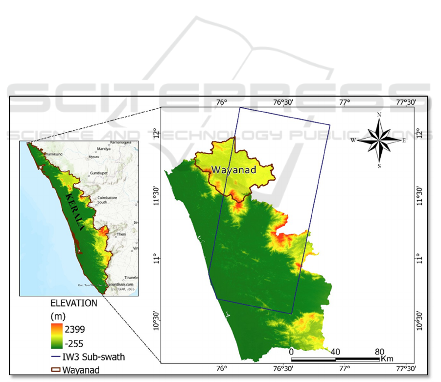
2 STUDY AREA
Wayanad District, located in the northeastern part of
Kerala, India, is known for its diverse geography and
significant natural beauty. The district is
characterized by its hilly terrain, with elevations
ranging from 700 to 2,100 meters above sea level and
is part of the Western Ghats Mountain range.
Wayanad’s landscape includes dense forests, lush
green tea and coffee plantations, and numerous rivers
and waterfalls. The region experiences a tropical
monsoon climate, with an average annual rainfall of
2,500 to 3,000 millimetres (India Meteorological
Department, 2024), contributing to its rich
biodiversity and dense vegetation. It is bordered by
the districts of Kannur to the west, Kozhikode to the
south, and Malappuram to the southwest. To the east,
Wayanad shares its boundaries with the state of
Karnataka. The district's geographical and climatic
conditions make it highly susceptible to landslides,
particularly during the monsoon season, which
highlights the importance of effective monitoring and
disaster management in the region. The present study
focuses on one sub-swath of a Sentinel-1 SAR image,
which encapsulates approximately 20,825 km² of
area, as shown in Figure 1.
Figure 1: Study Area.
GISTAM 2025 - 11th International Conference on Geographical Information Systems Theory, Applications and Management
114

Table 1: Data Characteristics of the Pre-Event Sar Images Using Stack Overview in Snap.
Acquisition date Track Orbit Temporal
Baseline (days)
Perpendicular
Baseline (m)
Modelled
Coherence
8 July 2024 (reference) 165 54662 0 0 1
20 July 2024 (secondary) 165 54837 12 -123 0.89
Table 2: Data Characteristics of the Post-Event Sar Images Using Stack Overview in Snap.
Acquisition date Track Orbit Temporal Baseline
(days)
Perpendicular
Baseline (m)
Modelled
Coherence
1
August
2024 (reference) 165 55012 0 0 1
13 August 2024 (secondary) 165 55187 12 -142 0.87
3 METHODOLOGY
3.1 Data Acquisition
This research leverages SAR datasets obtained from
the Sentinel-1A and 1B missions, launched in 2014
and 2016. These satellites are equipped with C-band
SAR technology, which offers open-access data
capable of capturing Earth's surface imagery under all
weather conditions, day and night. Sentinel-1
provides data well suited for medium-resolution
applications, with a revisit period of 12 days,
allowing for extensive area coverage. The satellites
operate in the Interferometric Wide (IW) swath mode,
utilizing Terrain Observation by Progressive Scans
(TOPS) to achieve a ground coverage of
approximately 250 km. The geometric resolution of
the SAR products is 5 m by 20 m in range and
azimuth, respectively.
For the application of the D-InSAR method, two
images were acquired before the landslide event
happened, and two were after the Wayanad landslide
to demonstrate the changes in the landform. Data
processing was performed using SeNtinel
Applications Platform (SNAP) version 10.0.0, a free
software provided by the European Space Agency
(ESA). The SAR data was sourced from the Alaska
Satellite Facility (ASF) and provided by the European
Space Agency (2023) as part of the Sentinel-1
mission. Each Sentinel-1 Single Look Complex
(SLC) product consists of three Interferometric Wide
Swaths (IW1, IW2, and IW3) and nine bursts. The
IW3 sub-swath was selected for this study as it
encompasses the area of interest. The acquired images
were in both VH and VV polarization modes. Tables
1 and 2 present the features of the pre-event and post-
event datasets, respectively.
The perpendicular baseline was kept within 200
meters to maintain data quality. This restriction helps
ensure accurate interferometric measurements and
reliable results in SAR data processing. The
perpendicular baseline is a critical parameter in SAR
interferometry, affecting the interferograms' spatial
resolution and coherence (Li & Bethel, 2008).
Keeping it within this limit helps minimize errors and
maintain the overall quality of the interferometric
data (Zhang et al., 2005).
3.2 Preprocessing
Preprocessing of the Sentinel-1 SAR data involves
several steps to ensure the accuracy of the DInSAR
analysis:
Orbit File Application: Accurate orbit data are
applied to the SAR images to correct for satellite
position errors. Precise orbit files provided by ESA
were utilized to ensure accurate geolocation and
alignment of the Sentinel-1 imagery.
Radiometric Calibration: This step involves
converting the SAR image data from digital numbers
(DN) to radar backscatter intensity, which is essential
for quantitative analysis.
Multilooking: The SAR images are multilooked to
reduce speckle noise inherent in SAR data by
averaging adjacent pixels. This study used a multi-
look factor of 4 in range and 1 in azimuth, reducing
noise while maintaining spatial resolution suitable for
analyzing landslide deformation.
Differential Interferometric Synthetic Aperture Radar-Based Landslide Monitoring: A Case Study of Wayanad, India
115

Co-registration: Pre and post-event SAR images are
precisely aligned to ensure accurate phase difference
calculations. This step minimizes phase errors due to
misalignment.
Interferogram Generation: An interferogram is
generated by computing the phase difference between
the co-registered SAR images. This interferogram
represents the ground displacement in the radar line
of sight (LOS).
3.3 DInSAR Processing
The core of the DInSAR technique involves the
following steps:
Phase Unwrapping: The interferometric phase is
wrapped between -π and π, necessitating a phase
unwrapping process to retrieve the actual
displacement values. The Statistical-cost Network-
flow Algorithm for Phase Unwrapping (SNAPHU)
algorithm is commonly used. This study employed
SNAPHU with a coherence mask to restrict
unwrapping to areas with a coherence threshold of
0.3, ensuring accurate displacement retrieval in high-
coherence regions.
Topographic Phase Removal: The influence of
topography on the interferometric phase is removed
using a Digital Elevation Model (DEM), such as the
Shuttle Radar Topography Mission (SRTM) DEM, to
isolate the phase related to ground deformation. A 30
m resolution SRTM DEM was used in this study to
ensure the precise removal of the topographic
component in the Wayanad region, characterized by
hilly terrain.
Temporal and Spatial Filtering: Temporal and
spatial filtering techniques reduce noise and enhance
the signal related to ground deformation. With an
adaptive window size of 32 x 32 pixels, the Goldstein
filter preserves deformation-related signals while
reducing noise.
Displacement Map Generation: The unwrapped
phase is converted into displacement maps
representing the ground movement in the radar LOS
direction. These maps are then geocoded to produce
spatially accurate deformation maps. This study
projected the displacement maps onto the WGS84
coordinate system for spatial analysis and visual
interpretation of ground deformation pattern.
4 RESULTS AND DISCUSSIONS
The results obtained after the dataset's preprocessing
demonstrate the landform change before and after the
event. The LOS displacement and coherence maps
were generated. This analysis helps us showcase the
land movement that happened towards or away from
the radar line of sight. P et al. (2025) used machine
learning models to determine the landslide
susceptibility in the Wayanad district and found that
the western part was most susceptible to landslides.
Thus, the coherence and displacement values of these
areas are discussed.
The observation from the Maps in Figures 2 to 5
from the estimated coherence suggests several
important conclusions:
4.1 Coherence Analysis
Before the Landslide: The pre-landslide surface
stability of the Wayanad region is evident from the
coherence map in Figure 2, where 57.8% of the pixels
exhibit coherence values above 0.6. This indicates
predominantly stable ground. 25.3% of the region
displays high coherence values (0.8–1.0), typically
associated with undisturbed surfaces like rocky
terrain or dense vegetation. Such areas reflect
minimal displacement or deformation.
Conversely, regions with coherence values below
0.4, constituting 15.7% of the pixels, primarily occur
in riverbeds and forested areas, as seen from the
histogram in Figure 3. These zones experience
temporal decorrelation due to vegetation growth, soil
moisture variations, or minor ground movements,
which are unstable precursors. Some areas' relatively
lower coherence values (0–0.53) suggest potential
surface instability or subtle deformations, even before
the landslide event.
After the Landslide: Following the landslide
triggered by intense monsoon rainfall, significant
displacement and surface disruption are observed,
particularly in areas near Mundakkai Hills,
Punchrimattom, Mundakkai, and Chooralmala
(Figure 4). These locations were selected for
monitoring due to their proximity to steep slopes,
historical landslide occurrences, and the presence of
vulnerable settlements and infrastructure.
The coherence values in these regions decreased
notably, reflecting ground instability and
displacement. At Mundakkai Hills, coherence
dropped from an average of 0.75 (pre-event) to 0.42
(post-event). Similarly, Punchrimattom experienced
GISTAM 2025 - 11th International Conference on Geographical Information Systems Theory, Applications and Management
116

a reduction from 0.81 to 0.46, and Mundakkai
decreased from 0.84 to 0.48. The most severe
displacement occurred near Chooralmala, where
coherence dropped from 0.77 to 0.32, indicating
significant material flow and surface disruption.
Figure 5 demonstrates only 34.2% of the pixels-
maintained coherence above 0.6 after the landslide,
compared to 57.8% before the event. Regions with
coherence values in the range of 0.2–0.4 increased
significantly, from 9.8% (pre-event) to 28.6% (post-
event), indicating widespread ground displacement.
Additionally, areas with coherence below 0.2,
representing 12.3% of the pixels, correspond to zones
of extreme surface disturbance caused by material
displacement during the landslide.
The spatial analysis of displacement highlights
the utility of SAR-based techniques in mapping and
quantifying ground movement. The coherence maps
provide a reliable measure of surface stability, with
changes in coherence values reflecting the severity
and extent of the landslide. These findings align with
observations by (Ferretti et al., 2001), who
emphasized the effectiveness of SAR coherence
analysis in monitoring ground deformation following
natural disasters.
From all above, it can be observed that the
coherence analysis underscores the substantial
alterations in surface properties caused by the
landslide, with significant changes in coherence
values reflecting both the extent of the ground
displacement and the areas of severe surface
disturbance. These results are critical for
understanding the landslide's overall impact, as they
provide detailed insights into the spatial distribution
of ground instability and the transformation of surface
conditions. The observed increase in coherence in
certain regions post-event suggests the exposure of
more stable and homogeneous surfaces, likely due to
the compaction and redistribution of material during
the landslide. This analysis highlights the event's
severity and establishes a reliable foundation for
developing future monitoring strategies, enabling
better risk assessment, mitigation efforts, and
informed planning for disaster-prone regions.
4.2 Displacement and Surface Stability
Figures 6 and 7 illustrate the LOS displacement maps
of the Wayanad region before and after the landslide
event, respectively. These maps provide critical
insights into the extent and movement of the landslide
as detected by the radar system. The LOS
displacement, measured in the radar line-of-sight
direction, highlights surface movement both towards
and away from the radar sensor.
Before the Landslide: The displacement map before
the event, shown in Figure 6, indicates stable surface
conditions with relatively uniform displacement
values across the region. Displacement values
predominantly range between -0.0014 m and 0.0048
m, suggesting minor ongoing ground movement
potentially related to environmental or geological
activity. Areas such as Mundakkai Hills,
Punchrimattom, and Chooralmala exhibit minimal
displacement, underscoring the absence of significant
pre-event deformation.
After the Landslide: The post-event displacement
map, shown in Figure 7, demonstrates substantial
changes in surface movement triggered by the
landslide. Negative displacement values (presented in
blue) represent movement away from the radar sensor
and are prominently observed in the areas most
impacted by the landslide, such as Chooralmala.
Maximum negative displacement values reach
approximately -0.0118 m, reflecting the material's
downward and outward movement from the hillside
during the landslide's initiation. In contrast, high
positive displacement values (depicted in yellow)
correspond to regions where the surface moved
towards the radar sensor, likely indicating debris
accumulation. This phenomenon is evident in the
towns of Mundakkai and Chooralmala, where
positive displacement values of up to 0.0118 m are
observed, suggesting debris flow and subsequent
compaction. The displacement maps effectively
capture the dynamic nature of the landslide. The pre-
event SAR images reveal small-scale displacements
indicative of ongoing ground activity, while the post-
event deformation map highlights pronounced
changes resulting from the landslide. The stark
contrast between the negative and positive
displacement values represents the landslide’s
impact, illustrating the initiation of material flow
from the hillside and the accumulation of debris in
surrounding areas, including Mundakkai and
Chooralmala. These results underscore the utility of
InSAR-derived LOS displacement data in detecting
and quantifying surface changes. The analysis
demonstrates the radar system’s capability to track
the landslide's initiation and the subsequent debris
flow, providing valuable insights into the event's
impact and progression.
Differential Interferometric Synthetic Aperture Radar-Based Landslide Monitoring: A Case Study of Wayanad, India
117
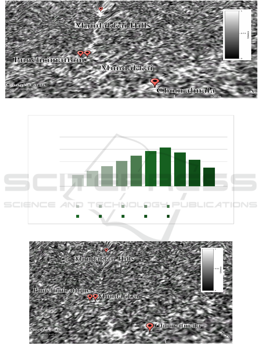
Figure 2: Coherence monitored before the landslide event.
Figure 3: Pixel-based analysis of coherence before the landslide event.
Figure 4: Coherence monitored after the landslide event.
1837
2491
3246
4105
4952
5701
6310
5473
4295
3019
0
2000
4000
6000
8000
Pixel Count
Coherence Range
Pixel Coherence Before the Landslide event
0.0 - 0.1 0.1 - 0.2 0.2 - 0.3 0.3 - 0.4 0.4 - 0.5
0.5 - 0.6 0.6 - 0.7 0.7 - 0.8 0.8 - 0.9 0.9 - 1.0
GISTAM 2025 - 11th International Conference on Geographical Information Systems Theory, Applications and Management
118
Figure 5: Pixel-based analysis of coherence after the landslide event.
Figure 6: Displacement towards radar LOS before the landslide event.
Figure 7: Displacement towards radar LOS after the landslide event.
2114
2785
3398
4321
5223
6012
6584
5547
4198
3109
0
2000
4000
6000
8000
Pixel Count
Coherence values
Pixel Coherence after the Landslide event
0.0 - 0.1 0.1 - 0.2 0.2 - 0.3 0.3 - 0.4 0.4 - 0.5
0.5 - 0.6 0.6 - 0.7 0.7 - 0.8 0.8 - 0.9 0.9 - 1.0
Differential Interferometric Synthetic Aperture Radar-Based Landslide Monitoring: A Case Study of Wayanad, India
119

5 CONCLUSION
This study demonstrated the successful application of
DInSAR using Sentinel-1 SAR data to monitor the
Wayanad landslide of July 30, 2024. By analyzing
four SAR images captured before and after the event,
coherence and LOS displacement maps were
generated, providing a detailed assessment of the
landslide’s extent and dynamics. The pre-event
coherence map revealed stable surface conditions,
with 57.8% of pixels maintaining coherence above
0.6. In contrast, the post-event coherence map
indicated significant ground deformation, with
coherence values above 0.6 dropping to 34.2% and
regions with coherence below 0.2 increasing to
12.3%. These changes highlight the substantial
disturbance caused by the landslide.
The LOS displacement map further quantified
surface movement, with negative values (up to -0.011
m) reflecting downward displacement in the affected
areas and positive values indicating debris
accumulation. This displacement pattern revealed the
spatial dynamics of the landslide, from initial material
displacement to subsequent debris deposition in the
Mundakkai, Punchrimattom, and Chooralmala
regions.
Triggered by slope instability due to intensified
rainfall, the Wayanad landslide demonstrates the
utility of DInSAR for rapid and accurate assessment
of rainfall-induced landslides. The technique
effectively detected and quantified ground
deformation, providing critical insights into the
event's mechanisms and extent. These results
emphasize the importance of integrating SAR-based
remote sensing into landslide monitoring systems,
enabling timely assessments for emergency response
and long-term hazard mitigation. Future studies could
incorporate advanced InSAR techniques to monitor
the annual rate of slope movement and improve early
warning systems in regions prone to recurring
landslides. This research highlights the potential of
DInSAR to enhance our understanding of landslide
dynamics and support disaster management efforts in
vulnerable areas.
REFERENCES
Debevec Jordanova, G., Popović, Z., Yastika, P. E.,
Shimizu, N., Oštir, K., & Verbovšek, T. (2024). SBAS
DInSAR and in situ monitoring of the Šumljak
landslide (SW Slovenia) dynamics driven by rainfall
and piezometric-level fluctuation. Landslides.
https://doi.org/10.1007/s10346-024-02408-4
European Space Agency (ESA). SNAP-Sentinel
Application Platform, v.10.0.0. https://step.esa.int/
main/toolboxes/snap.
Ferretti, A., Prati, C., & Rocca, F. (2001). Permanent
scatterers in SAR interferometry. IEEE Transactions on
Geoscience and Remote Sensing, 39(1), 8–20.
https://doi.org/10.1109/36.898661
Gadgil Madhav. (2011). Report of the Western Ghats
Ecology Expert Panel Part I.
India Meteorological Department. (2024). Cumulative
Rainfall For Kerala-Sw Monsoon 2024.
Kuriakose, S. L., Sankar, G., & Muraleedharan, C. (2009).
History of landslide susceptibility and a chorology of
landslide-prone areas in the Western Ghats of Kerala,
India. Environmental Geology, 57(7), 1553–1568.
https://doi.org/10.1007/s00254-008-1431-9
Lau, R., Seguí, C., Waterman, T., Chaney, N., & Veveakis,
M. (2024). InSAR-informed in situ monitoring for
deep-seated landslides: insights from El Forn
(Andorra). Natural Hazards and Earth System
Sciences, 24(10), 3651–3661. https://doi.org/10.5194/
nhess-24-3651-2024
Li, Z., & Bethel, J. (2008). Image Coregistration In Sar
Interferometry.
Mishra, A. (2024, August 1). Explained with maps: How
topography, human density led to devastation in
Kerala’s Wayanad. The Print. https://theprint.in/the
print-essential/explained-with-maps-how-topography-
human-density-led-to-devastation-in-keralas-wayanad/
2202631/
National Remote Sensing Centre, I. S. R. O. (2023).
Landslide Atlas of India (Mapping, Monitoring and
R&D studies using Remote Sensing data).
https://www.nrsc.gov.in
P, L., C, M., Mathew, A., & Shekar, P. R. (2025). Machine
learning and deep learning-based landslide
susceptibility mapping using geospatial techniques in
Wayanad, Kerala state, India. HydroResearch, 8, 113–
126. https://doi.org/10.1016/j.hydres.2024.10.001
Premlet B. (2019). Landslides In Kerala 2018 Chair,
Educational activities IEEE Kerala Section (Vol. 23).
Zhang, H., Zeng, Q., Liu, Y., Li, X., & Gao, L. (2005). The
Optimum Selection of Common Master Image for Series
of Differential SAR Processing to Estimate Long and
Slow Ground Deformation. Master Image for Series of
Differential SAR Processing to Estimate Long and Slow
Ground Deformation. http://dx.doi.org/10.1109/IGAR
SS.2005.1526688.
GISTAM 2025 - 11th International Conference on Geographical Information Systems Theory, Applications and Management
120
