
ADAclassifier: Trying to Ascertain Why the Ground Is Moving
Jos
´
e A. Navarro
1 a
, Anna Barra
1 b
, Mar
´
ıa Cuevas-Gonz
´
alez
1 c
, Pablo Ezquerro
2 d
,
Silvia Bianchini
3 e
, Marta B
´
ejar-Pizarro
2 f
, Riccardo Palam
`
a
1 g
and Oriol Monserrat
1 h
1
Centre Tecnol
`
ogic de Telecomunicacions de Catalunya-CERCA, Castelldefels, Spain
2
Geohazards InSAR Laboratory and Modelling Group (InSARlab), Geohazards and Climate Change Department,
Geological and Mining Institute of Spain (IGME-CSIC), Madrid, Spain
3
Universit
`
a Degli Studi di Firenze (UNIFI), Dipartimento di Scienze della Terra, Firenze, Italy
fi
Keywords:
Ground Motion, Ground Motion Classification, Active Deformation Areas.
Abstract:
The large availability of ground deformation measurements generated using Multi-Temporal Synthetic Aper-
ture Radar (MT-InSAR), further increased by the contribution made by the European Ground Motion Service
(EGMS), made displacement maps an increasingly common tool. However, their analysis is a complex task
due to the large volume of Measurement Points (MPs) provided. ADAfinder, a tool within the ADAtools
suite, allows for a reduction in the volume of information to be analyzed by identifying Active Deformation
Areas (ADAs), i.e., areas of the terrain that actually move in a coherent and perceptible manner, including an
estimate of the reliability of said identification. From here, the natural next step is identifying the reason why
these areas are moving. This work presents ADAclassifier, another tool included in the ADAtools suite, still
under development, aimed at evaluating up to five possible causes of ground movement, such as subsidence,
landslide, uplift, sinkhole, and constructive settlement.
1 INTRODUCTION
In recent years, the widespread availability of dis-
placement maps over large areas, generated us-
ing Multi-Temporal Synthetic Aperture Radar (MT-
InSAR) satellite interferometry techniques, has sig-
nificantly grown. The launch of the Copernicus
Sentinel-1 satellites in 2014, which provide global
and consistent data acquisitions under an open-access
and free data distribution policy, represented a major
shift in both their use and application.
A key result of this advancement has been the
creation of regional, national, and continental ground
motion services, offering detailed displacement maps
that deliver in-depth insights into both human activ-
ities and natural events. Since 2022, the European
a
https://orcid.org/0000-0001-7877-1516
b
https://orcid.org/0000-0001-6254-7931
c
https://orcid.org/0000-0002-4988-5669
d
https://orcid.org/0000-0001-8667-5030
e
https://orcid.org/0000-0003-2724-5641
f
https://orcid.org/0000-0001-7449-4048
g
https://orcid.org/0000-0001-6121-9485
h
https://orcid.org/0000-0003-2505-6855
Ground Motion Service (EGMS) (EGMS, 2017) has
been freely offering billions of displacement Mea-
surement Points (MP), updated annually, with cover-
age spanning almost all of Europe. These maps are
known for their high accuracy and precision.
Although these maps hold great potential for ter-
ritorial management and risk assessment, they remain
underutilized due to the difficulties related to their in-
terpretation; thus, automated tools that can streamline
and speed up the processes of data extraction, anal-
ysis, and interpretation are needed. The creation of
derived and simplified maps is essential to increase
the adoption of said products by both expert and non-
expert InSAR users. In this context, we introduce
the ADAtools (Active Deformation Area tools (Barra
et al., 2017; Tom
´
as et al., 2019; Navarro et al., 2020).
The ADAtools include several tools; among them,
it is important to highlight ADAfinder and ADAclas-
sifier. The first one, ADAfinder, facilitates the au-
tomatic extraction and selection of the most signifi-
cant Active Deformation Areas (ADAs) (Barra et al.,
2017), serving as a critical first step in transforming
a large number of individual MPs into a more man-
ageable set of polygons for further analysis or appli-
128
Navarro, J. A., Barra, A., Cuevas-González, M., Ezquerro, P., Bianchini, S., Béjar-Pizarro, M., Palamà, R. and Monserrat, O.
ADAclassifier: Trying to Ascertain Why the Ground Is Moving.
DOI: 10.5220/0013195100003935
In Proceedings of the 11th International Conference on Geographical Information Systems Theory, Applications and Management (GISTAM 2025), pages 128-135
ISBN: 978-989-758-741-2; ISSN: 2184-500X
Copyright © 2025 by Paper published under CC license (CC BY-NC-ND 4.0)
cation.
Figure 1 shows the process performed by
ADAfinder. At the top, all existing MPs in some area
can be observed. It can be seen that the volume of
available information makes the analysis a difficult
task. At the bottom, the ADAs detected by ADAfinder
are displayed. It is important to emphasize that the
amount of information the expert needs to analyze is
significantly lower. Additionally, together with the
polygons describing the areas of interest, an assess-
ment of the reliability associated with the polygons
is included, which establishes a scale of four values,
ranging from 1, “very reliable” to 4 “very unreliable.”
This quality index let the expert focus on those find-
ings that have a greater likelihood of being accurate.
Figure 1: ADAfinder: from a plethora or measurement
points to a few polygons depicting the Active Deformation
Areas (ADAs). The quality index stands for the reliability
of the results. ADAs in class 4 (“very unreliable”) are not
shown. Source: (Barra et al., 2017).
ADAfinder is a well-seasoned tool, used in nu-
merous projects since 2017, including U-Geohaz (So-
lari et al., 2020) and MOMPA (Gasc-Barbier et al.,
2021) among others. One of the most recent projects
(Navarro et al., 2022; Navarro et al., 2023) aimed to
publish ADAs for almost all of Europe on the web,
processing MPs published by the EGMS (see Fig-
ure 2). (Navarro, 2024b) includes a very detailed de-
scription of the ADAfinder tool.
Once moving areas or ADAs have been iden-
tified, ADAclassifier—–this work’s primary focus–
—enables an initial assessment of the processes likely
responsible for the displacement. By integrating aux-
iliary data—such as inventories of several kinds and
a Digital Terrain Model (DTM)—each ADA is given
a preliminary characterization with regard to five dif-
ferent ground movement processes: landslides, sub-
sidence, sinkholes, construction settlements, or up-
lift. Like ADAfinder, ADAclassifier also provides an
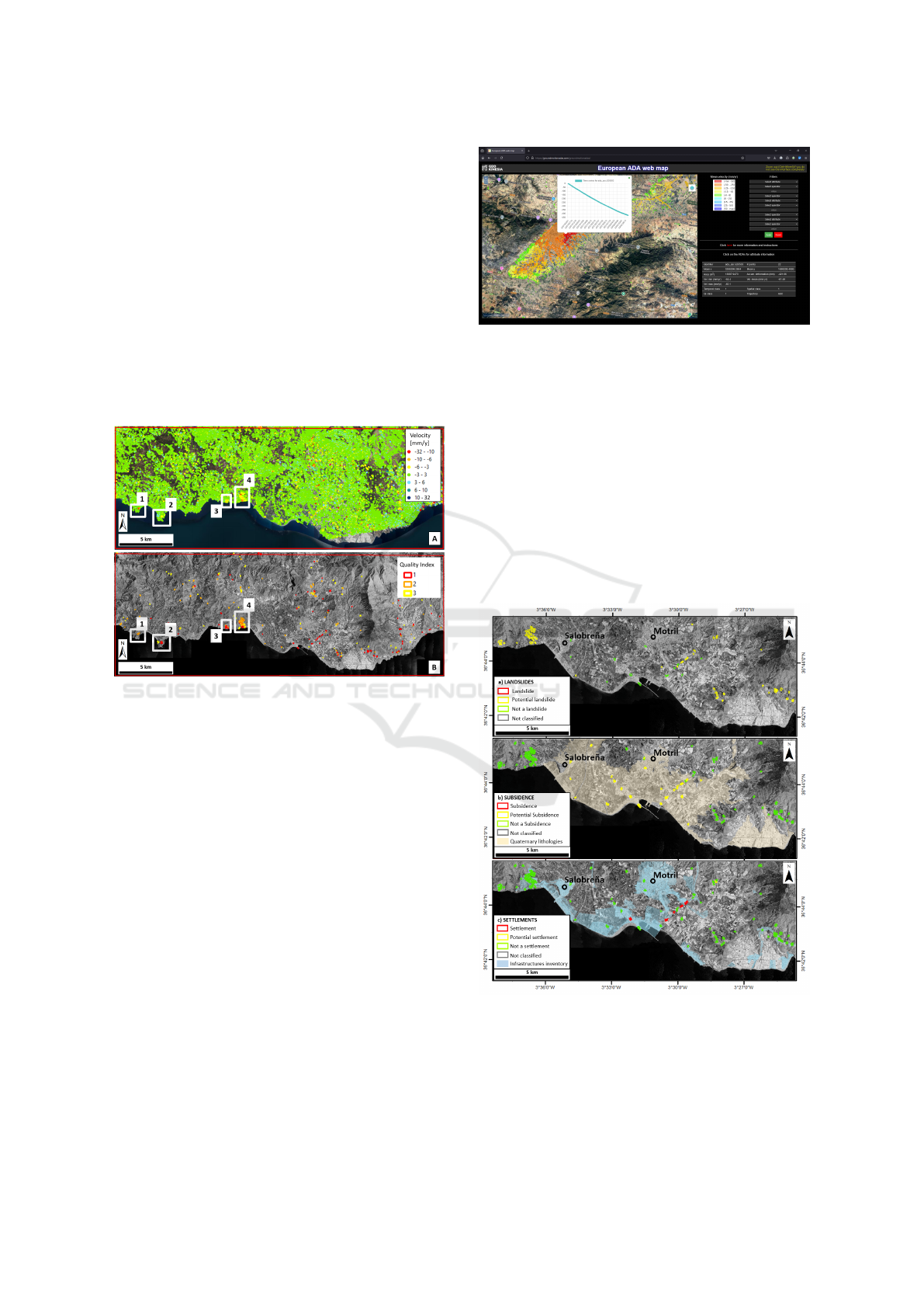
Figure 2: The European ADA web map (https://
groundmotionadas.com). The ADAs were identified by the
ADAfinder tool.
assessment of the reliability of the results obtained,
again with the goal of helping the expert to analyze
said results. This assessment is once again summa-
rized into four levels of reliability, from best to worse.
Figure 3 shows the classification results produced
by the original version of ADAclassifier for the ex-
ample area shown in Figure 1, considering only three
processes: landslides, subsidence, and constructive
settlement. The reliability of the results has been
highlighted using different colors: red, yellow and
green (from positive to negative certainty).
Figure 3: ADAclassifier (original version): for each ADA,
its potential correspondence to one of the different types of
analyzed ground movements is assessed. Source: (Navarro
et al., 2020).
The first implementation of the ADAtools dates
to 2017. Since then, they have been used in numer-
ADAclassifier: Trying to Ascertain Why the Ground Is Moving
129
ous projects and have undergone a series of improve-
ments leading to the current version. ADAclassifier
was included in the ADAtools since their very first
version. However, unlike ADAfinder, its initial re-
lease had many limitations, which have recently been
addressed. This work discusses how.
2 ADAclassifier
As just mentioned, the original version of ADAclas-
sifier had several flaws, making it highly advisable to
replace it with a new implementation that addressed
these issues. This section describes these flaws and
explains how the new version of the tool addressed
them.
2.1 The First Version of the Tool
The core problem lay in the simplicity of the algo-
rithms used to determine whether a ground movement
corresponded to one phenomenon or another. Those
algorithms were an initial approach to solving the
problem. In fact, each of the tests aimed at determin-
ing whether a ground movement was due to a specific
type of process (i.e., landslide or settlement) relied on
a unique decision tree (one per process). For exam-
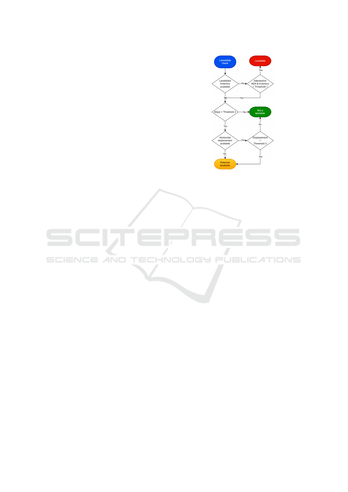
ple, Figure 4 depicts the tree used by the landslide
test. Additionally, the number of variables these al-
gorithms considered, such as the slope value or hor-
izontal ground displacement, was relatively limited.
These algorithms were still far from modeling reality
reasonably, as they can be considered a first and early
attempt at approaching the problem.
Furthermore, these algorithms largely depended
on the availability of inventories related to the type of
process being evaluated, such as geological or con-
struction settlement inventories. Their absence in-
evitably led to results that never confirmed that the
ground movement in question was caused by the
tested process. In other words, if a landslide inven-
tory was not available, the ground movement would
never be classified as a landslide; at best, it would be
labeled as a “potential landslide”. See again Figure 4.
The simplicity of the algorithms and the lim-
ited availability of inventories explain the low con-
fidence in ADAclassifier’s results. These algorithms
only consider a small portion of the reality of ground
movements, overlooking many factors. Additionally,
the lack of inventories forces the algorithms into a
more conservative mode, hindering their ability to
confidently affirm the occurrence of a specific phe-
nomenon. This undermines trust in the results.
Figure 4: The unique algorithm (decision tree) used by the
old version of ADAclassifier to decide whether a ground
movement was produced by a landslide. The threshold val-
ues are provided by the user. Excerpted from (Tom
´
as et al.,
2019).
Another significant issue plaguing the first ver-
sion of ADAclassifier was performance. As previ-
ously mentioned, inventories played a crucial role in
the implementation of the old version of the tool. In
fact, they were used (when available) by the algo-
rithms implementing every ground motion detection
process. From ADAclassifier’s perspective, an inven-
tory is a file containing polygons that define the areas
of the terrain where a specific phenomenon occurs.
Some inventories may also include additional data re-
lated to each polygon; the geological inventory is a
clear example: a value states the type of lithology re-
lated to the polygon. The typical “inventory check”
consisted of computing the percentage of intersection
of the polygon defining the ADA with those included
in said inventory. Due to the very poor implementa-
tion of this process, ADAclassifier’s performance was
far from satisfactory, making its use on projects with
territorial coverage beyond the local level impossible.
The team responsible for both the development
(and on many occasions also for the exploitation) of
ADAclassifier were aware of the need for a redesign
of the tool that could be relied upon. These are the
reasons that led to the decision to create the new ver-
sion of ADAclassifier that is described in the next sec-
tion.
2.2 The New ADAclassifier
This section analyzes the changes undergone by
ADAclassifier from different perspectives: its inputs,
algorithms, outputs, performance and reliability.
GISTAM 2025 - 11th International Conference on Geographical Information Systems Theory, Applications and Management
130

2.2.1 The Inputs
From a user standpoint, the new version of ADAclas-
sifier is virtually identical to the original. In fact, al-
most all of the input files are the same in both cases.
The following is a brief list of these files, indicating
when applicable which ones are needed only in the
new version.
1. ADAs (polygons) and the points used to construct
them.
2. Digital Terrain Model (DTM) or, alternatively,
slope and aspect maps (the last two being exclu-
sive to the new version).
3. Inventories: landslides, sinkholes, subsidence,
constructive settlements, geological.
4. Horizontal displacement and, only for the new
version, vertical displacement.
From the previous list, only the files from points
1 and 2 are mandatory, and, in fact, in point 2, it is
possible to choose between the DTM or slope and as-
pect data. If the DTM is provided, then ADAclassi-
fier computes both the slope and aspect; if not, the
user must provide these two files as input instead of
the DTM. The rest of the files are optional, as in the
original version.
Actually, there are two additional input files in the
latest version of ADAclassifier (scores and score-to-
classes defaults). However, it is very rare for the end
user to have to manipulate them, as they include de-
fault values that should not normally be changed un-
less you are an expert in the subject. The content of
these files will be discussed later, since they are cru-
cial to making ADAclassifier a very flexible tool.
2.2.2 The Algorithms
The most significant changes have been made to
ADAclassifier’s algorithms. Within the framework of
the RASTOOL project (Montserrat et al., 2024; RAS-
TOOL project, 2024), a major effort has been made
to characterize the reasons behind different types of
ground movements. Specifically, for landslides, con-
structive settlements, sinkholes, subsidence and, new
for this version of ADAclassifier, also uplifts.
Several changes have affected the algorithms.
Firstly, their complexity has increased. Unlike the ini-
tial version, where a single decision tree based on a
few parameters was used to check a specific ground
movement process, now multiple trees have been in-
corporated. More specifically, these are 4 for land-
slides, 6 for constructive settlements, 5 for sinkholes,
5 for subsidence, and 4 for uplifts. This sums up to
a total of 24 checks, compared to the original 5. Fig-
ure 5 shows two of the four decision trees implement-
ing the landslide detection process. Note the THLAnn
(thresholds) and SCLAnn (scores) labels in said Fig-
ure. These are values input by the user controlling
the behavior of the algorithms and will be discussed
below.
This increase in the number of decision trees used
by the tool makes the detection processes for the dif-
ferent kinds of ground movements more exhaustive.
Additionally, the set of physical magnitudes being
checked has been expanded, including horizontal and
vertical displacement velocities, line of sight veloc-
ity, aspect, slope, the percentage of intersection of the
ADA with different inventories, and the r
2
coefficient
of fit of the deformation time series and an inverse ex-
ponential function. Some relationships between these
magnitudes are also checked. This is expected to re-
sult in greater reliability of the obtained results.
Together with the notable improvement resulting
from the increased number of decision trees and phys-
ical magnitudes involved, another significant key im-
provement factor is the way in which all these ele-
ments (trees, magnitudes, relationships) contribute to
the final outcome. In the first version of ADAclas-
sifier, all decision trees reached a definitive conclu-
sion about whether a given ground movement could
be labeled one way or another. This was materialized
with three possible outcomes for each kind of process:
“Not X”, “Potential X” or “Is X”, where “X” stands
for the different process types being checked (such as
sinkhole or subsidence). The user could only control
the values of the thresholds used in the decision trees
(see Figure 4).
Now, the procedure (for each type of process) con-
sists of adding or subtracting points to a cumulative
total or score. Each leaf of the decision trees con-
tributes a specific number of points, either positive or
negative, to the process evaluation.
These points are represented by the labels named
SCLAnn in the leaves of the decision trees in Fig-
ure 5, where SC stands for “Scoring”, LA indicates
that this score refers to the landslide process, and nn
is a numeral to distinguish one score from another.
These labels change depending on the detected pro-
cess; for example, in the case of sinkholes, the pattern
is SCSInn, where SI denotes the said sinkhole process.
Note that the thresholds for some magnitudes follow a
similar pattern; in this case these start with the letters
TH instead of SC.
Each of the leaves of the decision trees involved in
the detection contributes a certain number of points to
the final score, which will subsequently be used to de-
cide the status of the ground movement with respect
ADAclassifier: Trying to Ascertain Why the Ground Is Moving
131
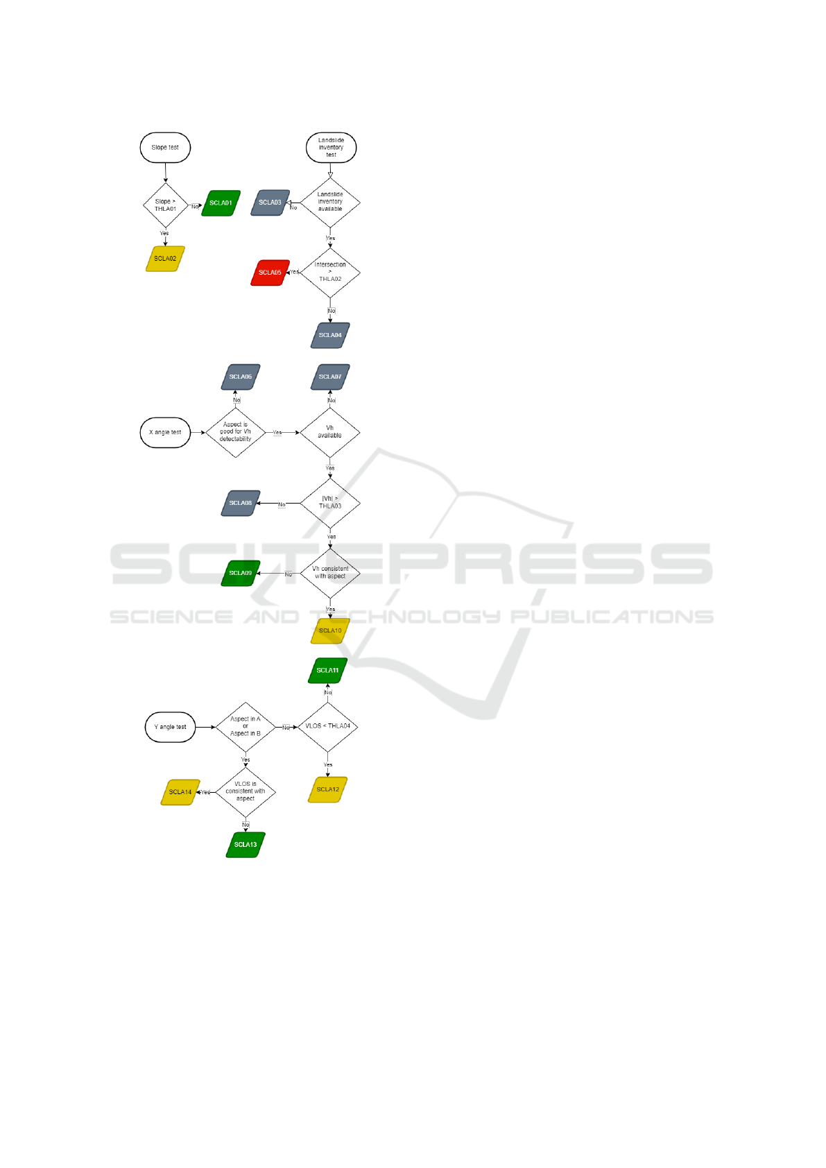
Figure 5: The four decision trees used by the new version
of ADAclassifier to determine if a ground movement might
be a landslide. Thresholds and scores are denoted by labels
like THLAnn and SCLAnn.
to the process being identified. For instance, in the
case of subsidence, there are five decision trees; con-
sequently, the final score will consist of the sum of the
points obtained in each of them.
The sum of both improvements (better decision
trees plus scoring) makes the detection of the type of
ground movement in which an ADA is involved more
reliable than before, since more situations are now
evaluated. In fact, it can be stated that the new version
of ADAclassifier is more resilient, as the score as-
signed to a given process is obtained through a combi-
nation of algorithms (the decision trees) and not from
a single one as before. The unavailability of some
data does not prevent an attempt to reach a conclu-
sion.
It is worth noting that the values of thresholds
and the number of points rewarded are customiz-
able through the tool’s configuration files. This of-
fers experts a high degree of flexibility, allowing them
to fine-tune those parameters without requiring code
changes. For example, to accurately model real-world
phenomena, threshold values such as slopes or hori-
zontal velocities may need adjustment. With regard
to scoring, changing the number of points assigned
to the leaves makes possible giving more or less im-
portance to the different cases depicted by the deci-
sion trees. Obviously, having greater flexibility im-
plies greater complexity: only experts are capable of
changing said values without breaking the applica-
tion.
2.2.3 From Scores to Classes
Despite the increased flexibility and reliability pro-
vided by the scoring system, it is necessary to offer
a final, simple categorization of the results. This im-
plies that these must be expressed through a reduced
number of classes. ADAclassifier performs this pro-
cess, translating the points obtained for each process
into a value that can be one of the following: “It is
not X”, “It may be X”, “It should be X”, and finally,
“It is X, where X, once again, represents each of the
processes being checked.
The key here is how the points are translated into
classes. This is done through a configuration file that
the expert can modify to fine-tune the system. In this
file, for each process, the ranges of points correspond-
ing to each class are specified. In this way, the tool
becomes even more flexible, allowing the expert to
make adjustments without needing to modify the tool
itself.
2.2.4 The Output
The unique output file is an extension of the input
file with ADAs. There, the original attributes are pre-
served, such as the polygon defining the perimeter of
the ADA or the Quality Index (QI) stating its relia-
bility. The interested reader may check the complete
GISTAM 2025 - 11th International Conference on Geographical Information Systems Theory, Applications and Management
132

list of attributes in (Navarro, 2024b) or in (Navarro,
2024a).
The extra fields added by ADAclassifier for each
ADA in the data set, which are related to the results
of the classification process, are:
• The mean values of slope and aspect for the ADA,
• as well as an extra flag stating whether the value
of the aspect above is good for some tests,
• the r
2
coefficient, measuring how good is the fit of
the ADA’s deformation time series and an inverse
exponential function,
• the percentage of intersection between the ADA’s
polygon and those in every available inventory or
geological maps,
• the score obtained and the corresponding class for
each of the five processes tested and, finally,
• a summary of the results, stating which is (or
are) the predominant process(es) making the ADA
move.
As can be observed in the list above, ADAclas-
sifier not only generates an answer regarding which
process(es) possibly originate(s) the ADAs, but also
exposes all the information used to reach that conclu-
sion. This not only serves to justify the answer pro-
vided but also allows the expert to analyze the results
in case they do not correspond to reality. Having this
information will allow the adjustment of algorithms,
thresholds, and scores, if necessary.
2.2.5 Performance Assessment. A Nationwide
Project
As stated in section 2.1 the low performance of the
first version of ADAclassifier was a serious problem,
caused, mainly, but among other issues, by the poor
implementation of the inventory checks. This new
release has solved all the problems the authors were
aware of, which has produced a noticeable boost in
performance that makes it possible to tackle not only
regional, but even nationwide projects.
In fact, to put the tool to the test, a total of 661
ADA datasets have already been processed, cover-
ing the entire surface of Spain, which is 506,000 km
2
and includes 21,526 ADAs. The ADAs were already
available since they were computed using ADAfinder
for the project described in (Navarro et al., 2022;
Navarro et al., 2023). To this data, we added a DTM,
as well as geological, landslide, and constructive set-
tlement inventories covering the entire territory. The
sinkhole inventory was only available for a very small
region measuring 17,274 km
2
, so its impact on perfor-
mance is negligible. The slope and aspect maps for all
Spain were calculated only once using the DTM. This
way, ADAclassifier did not need to regenerate them
when processing each data set.
The characteristics of the hardware follow:
• Processor (64-bit): 2 × Intel® Xeon® Silver
4309Y CPU @ 2.80 GHz, 2801 MHz, 8 Core(s),
16 Logical Processes.
• RAM: 384 Gb.
• Disk: 18 Tb, Magnetic (not SSD).
• Operating system: Microsoft Windows Server
2022 Standard.
• Year: 2020.
Processing the complete datasets (all Spain) took
just 8 hours, that is, less than 0.06 seconds per km
2
,
1.34 per ADA or 43.6 per data set. Note that the server
described above was not fully dedicated to ADAclas-
sifier for it is shared by about a dozen users launch-
ing CPU-consuming tasks. Therefore, results could
be still better if no concurrent processes competed for
the server’s resources.
Looking at these results, the authors believe that
the tool is well suited to process nationwide projects.
Said results also seem to indicate that it could be used
at a continental level.
2.2.6 Reliability Assessment
The reliability of the results has been continuously
verified since the first release of the new version of
ADAclassifier using some of the already available
datasets. The results of these initial analyses have
served to fine-tune the threshold and scoring files.
Thanks to the availability of EGMS data and thus
the processing of the entire Spanish datasets, we now
have a much larger volume of information to perform
this verification. Obviously, this is a large task due to
the overabundance of data (661 datasets), but it is pre-
cisely such abundance that will allow us to determine
with a reasonable level of certainty whether the con-
clusions of ADAclassifier are correct or if, in some
cases, the system needs further tuning.
In fact, and this is because the determination of
the causes of ground movements is not a settled is-
sue, some inconsistencies have already been detected
in a very small number of cases: apparently, a few
ADAs seems to be moving, according to ADAclassi-
fier, because of both landslide (down) and uplift (up)
processes, which is completely contradictory.
At the time of writing this work, the reason for
this problem was being analyzed. These cases will
be used to understand the algorithm behavior, thus
to adjust some thresholds and scores or to modify
ADAclassifier: Trying to Ascertain Why the Ground Is Moving
133

some of the decision trees that control the affected
processes—thus modifying the application.
Except for these rare exceptions, most ADAclas-
sifier’s results are reliable. However, verification by
an expert will always be recommended to ensure that
situations like the one just described do not go unno-
ticed.
3 CONCLUSION
Despite being available since 2018 as an integral part
of the ADAtools, the original version of ADAclassi-
fier has not been regularly used to attempt to deter-
mine the causes of ground movement due to this tool’s
performance issues but, primarily, because of the low
reliability of the results offered, which were obtained
by means of overly simplistic algorithms.
Recently, and within the framework of the RAS-
TOOL project, a great effort has been made to identify
the reasons why the five analyzed ground movement
processes occur. Ultimately, this effort was aimed
at improving the understanding of these processes,
which has resulted in a set of detection algorithms
closer to reality, materialized in the aforementioned
decision trees.
ADAclassifier is not yet a mature tool, but today
it is much closer to being able to be exploited regu-
larly in expert environments not necessarily involved
in research. It is true that notable defects have still
been detected, such as the already mentioned land-
slide/uplift dichotomy, but this is one more step to be
solved like the many others that have been overcome
to reach the current state of ADAclassifier. The avail-
ability of a large volume of EGMS data making possi-
ble the processing of ADAs at a national level opened
the doors to an extensive validation task, thanks to
which the authors are reasonably satisfied with the re-
liability of the results produced by tool.
Perhaps it is adventurous to advance a date on
which ADAclassifier can be considered a production
tool (in expert environments), but the authors consider
that, despite the aforementioned defects, that moment
is not far off. Probably this will happen by the end of
2024 or the beginning of 2025.
ADAclassifier is part of the ADAtools, which can
be downloaded for free at https://adatools.cttc.es.
ACKNOWLEDGMENTS
This work is part of the Spanish grant
SARAI, PID2020-116540RB-C21, funded by
MCIN/AEI/10.13039/501100011033.
REFERENCES
Barra, A., Solari, L., B
´
ejar-Pizarro, M., Monserrat, O.,
Bianchini, S., Herrera, G., Crosetto, M., Sarro, R.,
Gonz
´
alez-Alonso, E., Mateos, R. M., Lig
¨
uerzana, S.,
L
´
opez, C., and Moretti, S. (2017). A methodology to
detect and update active deformation areas based on
Sentinel-1 SAR images. Remote Sens., 9(10).
EGMS (2017). European Ground Motion Service (EU-
GMS) - A proposed Copernicus service element.
White paper, European Ground Motion Service.
Gasc-Barbier, M., Barra, A., Bux
´
o, P., Trapero, L.,
Crosetto, M., Colell, X., Fabregat, I., Echeverria,
A., and Marturia, J. (2021). Monitoring deforma-
tions related to geological risks with InSaR data – the
MOMPA project. IOP Conference Series: Earth and
Environmental Science, 833(1):012142.
Montserrat, O., Barra, A., B
´
ejar-Pizarro, M., Rivera, J.,
Galve, J. P., Guardiola, C., Cuevas-Gonz
´
alez, M., Ma-
teos, R. M., Ezquerro, P., Aza
˜
n
´
on, J. M., Shahbazi, S.,
Navarro, J., Crosetto, M., and Luzi, G. (2024). ADA-
tools: herramientas gratuitas y f
´
aciles de usar para
extraer y analizar semiautom
´
aticamente mapas de de-
splazamiento basados en interferometr
´
ıa multitempo-
ral. aplicaciones al European Ground Motion Service
(EGMS). In Proceedings of XX Congreso de la Aso-
ciaci
´
on Espa
˜
nola de Teledetecci
´
on.
Navarro, J., Garc
´
ıa, D., and Crosetto, M. (2023). New
challenges in the implementation and exploitation of
a low-cost web map of the Active Deformation Ar-
eas across Europe. In Proceedings of the 9th Interna-
tional Conference on Geographical Information Sys-
tems Theory, Applications and Management - Volume
1: GISTAM,, pages 192–199.
Navarro, J. A. (2024a). ADAclassifier’s user guide. In-
cluded in the ADAtools software package. Available
at: https://adatools.cttc.es.
Navarro, J. A. (2024b). ADAfinder’s user guide. In-
cluded in the ADAtools software package. Available
at: https://adatools.cttc.es.
Navarro, J. A., Garc
´
ıa, D., and Crosetto, M. (2022). An
in-house, self-developed low-cost WebGIS relying on
open-source and self-made tools to show the Active
Deformation Areas across Europe. In Proceedings of
the 8th International Conference on Geographical In-
formation Systems Theory, Applications and Manage-
ment.
Navarro, J. A., Tom
´
as, R., Barra, A., Pag
´
an, J. I., Reyes-
Carmona, C., Solari, L., Vinielles, J. L., Falco, S., and
Crosetto, M. (2020). ADAtools: Automatic detection
and classification of Active Deformation Areas from
PSI displacement maps. ISPRS Int. J. Geo-Inf., 9:584.
RASTOOL project (2024). RASTOOL.
https://rastool.cttc.es. Accessed on October 25,
2024.
Solari, L., Bianchini, S., Franceschini, R., Barra, A., Mon-
serrat, O., Thuegaz, P., Bertolo, D., Crosetto, M., and
Catani, F. (2020). Satellite interferometric data for
landslide intensity evaluation in mountainous regions.
Int. J. Appl. Earth Obs. Geoinf., 87.
GISTAM 2025 - 11th International Conference on Geographical Information Systems Theory, Applications and Management
134

Tom
´
as, R., Pag
´
an, J. I., Navarro, J. A., Cano, M., Pastor,
J. L., Riquelme, A., Cuevas-Gonz
´
alez, M., Crosetto,
M., Barra, A., Monserrat, O., L
´
opez-S
´
anchez, J. M.,
Ram
´
on, A., Iborra, S., del Soldato, M., Solari, L.,
Bianchini, S., Raspini, F., Novali, F., Ferreti, A.,
Constantini, M., Trillo, F., Herrera, G., and Casagli,
N. (2019). Semi-automatic identification and pre-
screening of geological-geotechnical deformational
processes using Persistent Scatterer Interferometry
datasets. Remote Sens., 11(14).
ADAclassifier: Trying to Ascertain Why the Ground Is Moving
135
