
Characterizing Machine Guidance in Geospatial Analysis
Yue Hao
a
and Guoray Cai
College of Information Sciences and Technology, The Pennsylvania State University, University Park, PA, U.S.A.
Keywords:
Geographic Information Systems, Geospatial Analysis, Machine Guidance.
Abstract:
Geospatial analysis poses challenges for individuals with limited expertise in Geographic Information Science
(GIScience) methods and tools, requiring complex decision-making and spatial reasoning, often leading to
difficulties or even failures. This research explores machine guidance as a novel approach to support domain
analysts throughout the geo-analytical process. This approach can be implemented as an intelligent inter-
face agent that is capable of recognizing user’s analytical difficulties and providing proactive assistance. We
propose a conceptual framework that characterizes the cooperative role of machine guidance in geospatial
analysis. We focus on answering two key research questions: (1) when to guide? and (2) how to guide?. The
framework provides a foundation for future research on machine-guided geospatial analysis, informing the de-
velopment of other computer-aided systems that enhance usability and analytical effectiveness in GIScience.
1 INTRODUCTION
Geospatial analysis is crucial to scientific investiga-
tion and decision-making in various domains (Good-
child and Longley, 1999), ranging from human-
environment interactions (De Smith et al., 2007), un-
derstanding the health impact of COVID-19 and vac-
cines (Sun et al., 2020; Wang et al., 2021; Mol-
lalo et al., 2021), healthcare resources (Kang et al.,
2020), to public health policies (Ram
´
ırez and Lee,
2020; Ahasan and Hossain, 2021). These demands
for geospatial analysis stimulated the rapid growth
of analytical tools and methods (Goodchild et al.,
2000). As Geographic Information Systems (GISys-
tems) grow into a type of high-functionality system, it
becomes increasingly harder to learn and use (Lieber-
man et al., 2015).
Despite its significance, geospatial analysis
presents challenges due to its complexity. It involves
processing and analyzing geographic data by repre-
senting spatial phenomena, utilizing tools and statis-
tical methods, and interpreting spatial relationships
(Bailey et al., 1995; Goodchild, 2006). Analysts must
recognize patterns in spatial data and understand their
underlying significance (Haining, 1994). At the tech-
nical level, geospatial analysis makes use of a variety
of analytical tools and techniques to understand geo-
graphic patterns and events (Goodchild, 1992). How-
ever, these tasks are often cognitively demanding and
a
https://orcid.org/0000-0002-8368-4924
require specialized knowledge and skills in geography
and GISystems, which are not universally accessible.
The complexity of geospatial analysis tools, com-
bined with the need for GIS expertise, creates barriers
for analysts, particularly those outside the GIS field.
Existing solutions primarily focus on two approaches.
The first approach involves empowering analysts by
offering education and training programs in geogra-
phy and GIScience (Council et al., 2005). While these
programs are valuable, they are not scalable due to
their high costs in terms of time and money. Sec-
ond, GISystem user interfaces have been enhanced
to better reflect how humans perceive, interact with,
and conceptualize the world to improve usability and
analytical capabilities (Goodchild, 2009). However,
even with improved interfaces, analysts still face sig-
nificant burdens, such as forming effective analytical
strategies, preparing data, and executing the required
spatial functions. These limitations highlight the need
for innovative solutions to make geospatial analysis
more accessible and efficient. To make geospatial
analysis practical to a diverse range of applications
and analysts, solutions are needed to bridge the cog-
nitive and skill gap.
Motivated by addressing the human cognition and
expertise barriers during spatial analysis, we propose
machine guidance (Ceneda et al., 2018) as a novel
approach to make geospatial analysis more accessi-
ble. The key idea of our approach is to introduce an
intelligent interface agent that offers timely help and
Hao, Y. and Cai, G.
Characterizing Machine Guidance in Geospatial Analysis.
DOI: 10.5220/0013240300003935
In Proceedings of the 11th International Conference on Geographical Information Systems Theory, Applications and Management (GISTAM 2025), pages 39-50
ISBN: 978-989-758-741-2; ISSN: 2184-500X
Copyright © 2025 by Paper published under CC license (CC BY-NC-ND 4.0)
39

guidance when analysts encounter difficulties in ad-
vancing their analytical goals. A machine guidance
agent is able to recognize when users are facing dif-
ficulties and take the initiative to guide them with
appropriate actions (Liu et al., 2018; Ceneda et al.,
2019). By leveraging the guidance agent’s expertise,
human analysts’ efforts and cognitive load in identify-
ing clues or suitable solutions when facing challenges
can be reduced. Thus, the machine guidance agent is
particularly valuable for domain experts who are pro-
ficient in their specific problem domain but with lim-
ited expertise in GISystems or GIScience (Nyerges,
1995; Traynor, 1998).
Effective machine guidance agent requires two
key capabilities. First, the guidance agent must be
able to recognize when analysts are facing challenges
and whether guidance is needed. Second, it must be
able to determine what types of guidance will be pro-
vided based on the nature of user challenges. The
overall goal is to make an analytic process produc-
tive and effective even in cases where users’ exper-
tise is inadequate. Towards defining the conceptual
framework for machine guidance in geospatial analy-
sis, we explore two key questions to inform its design
and implementation:
1. When is guidance needed during the geospatial
analytical process? This involves understanding
the nature of geospatial analysis process and iden-
tifying the points when users might face chal-
lenges.
2. How should guidance be provided? Answering
this question involves understanding alternative
messages and media for communicating guidance
and how to choose them to ensure effectiveness
and keep them minimally intrusive.
By addressing these two research questions, we
aim to characterize a conceptual framework for ma-
chine guidance in geospatial analysis. We begin by
conceptualizing the geoanalytical process to identify
when guidance is most needed. Using a hypotheti-
cal scenario, we illustrate how machine guidance can
be integrated into the analytical process in various
forms. A better understanding of when and how guid-
ance should be designed contributes to the develop-
ment of a science of design for machine guidance.
It can fill the gap that there is a lack of understand-
ing of the machine guidance behaviors in facilitating
geospatial analysis. It also can be reused or further
developed regarding the mixed-initiative guidance de-
sign in the GIS domain. Potentially, it can advance the
GIScience agenda on the design and use of effective
machine guidance to amplify human capacity for spa-
tial problem-solving.
2 LITERATURE REVIEW
2.1 Conceptualize Geospatial Analysis
Geospatial analysis is a complex problem-solving
process that integrates spatial thinking to address sci-
entific questions and support decision-making (Good-
child and Longley, 1999; Fischer et al., 2011). Unlike
other analytical domains, geospatial analysis requires
viewing problems with a “geographical eye”, empha-
sizing spatial relationships, patterns, and interconnec-
tions (Downs, 1997). This process involves systemat-
ically handling spatial data and extracting meaningful
insights, ensuring that spatial objects and their rela-
tionships are accurately represented and understood
(Haining, 1994). As an iterative analytical method,
it involves multiple stages, including problem identi-
fication, strategy formation, analysis, and evaluation
(De Smith et al., 2007; Bednarz et al., 2013). We cat-
egorize this process into Figure 1. Each step demands
cognitive and computational efforts to effectively in-
terpret spatial phenomena, manage uncertainties, and
optimize solutions (Goodchild and Janelle, 2010).
The problem-solving aspect of geospatial analy-
sis requires structuring ill-defined spatial problems
into well-represented phenomena using spatial con-
cepts such as distance, orientation, connectivity, and
scale (Huisman et al., 2009; Miller and Wentz, 2003).
Analysts must carefully choose external representa-
tions and operations based on the inherent uncer-
tainties in geographic data, as spatial representations
and scales influence analytical outcomes (Couclelis,
2003; Grekousis, 2020). Effective geospatial analy-
sis also depends on the strategic integration of data,
logical task sequencing, and cognitive reasoning to
synthesize and evaluate spatial information dynam-
ically (D
¨
orner and Kreuzig, 1983; Thomas, 2005).
Since spatial problems lack predefined solutions, iter-
ative refinement, and expert judgment are necessary
to improve decision-making and ensure analytical ac-
curacy (Pretz et al., 2003; Bednarz, 2004).
Figure 1 illustrates the workflow and components
involved in geospatial analysis conducted by a human
analyst. Analysts, as domain experts, typically start
by defining a problem within their specific field. The
problem should then be translated into a spatial repre-
sentation based on the analytical phenomena and their
interactions. Next, the spatial problem can be bro-
ken down into a series of questions that GIS tools
can address. Addressing these questions often re-
quires executions and operations in a coherent work-
flow within GISystems. Based on the GIS outputs,
the analyst compares and selects strategies. The ana-
lyst also needs to synthesize and evaluate the outputs
GISTAM 2025 - 11th International Conference on Geographical Information Systems Theory, Applications and Management
40
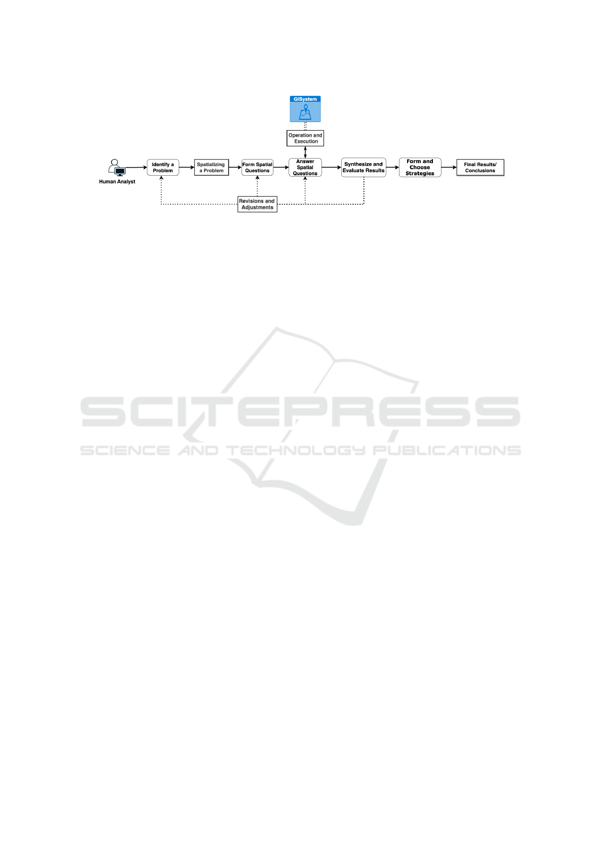
Figure 1: The geoanalytical process that requires a series of tasks and decisions.
and intermediate results to actively evaluate and ad-
just their analytical workflow as well as the problem-
solving strategies.
2.2 Cognitive Challenges of Geospatial
Analysis and the Need for Support
Geospatial analysis includes an essential goal of mak-
ing critical decisions based on locations. It improves
one’s understanding of the geographic phenomenon
presented by the data by discovering and revealing the
previously unknown patterns (Huisman et al., 2009).
Cognitively, it is challenging to see things and situ-
ations spatially for structuring problems, finding an-
swers, and expressing solutions (Council et al., 2005).
Generating new knowledge from the result requires
human reasoning and understanding (Ward et al.,
1999). It requires thinking and operational skills from
three different dimensions: spatial concepts, spatial
representation, and spatial reasoning (Council et al.,
2005).
However, constraints of human perception and
cognition, such as limited field of view in percep-
tion and working memory in cognition, have been
documented in psychological studies (Baars, 1997;
Baddeley, 1992; Creem-Regehr et al., 2005). These
limitations impact how we perceive and comprehend
complex data and situations. Choosing the suitable
representation, for instance, is a demanding task that
requires one’s cognitive efforts in deciding the ex-
plicit relation and structures of the space as well as
the unknown parts (e.g. data scale and aggregation
level) that one is going to explore (Freksa et al., 2017;
De Smith et al., 2007). Spatial representation should
match the spatial phenomenon as well (Dungan et al.,
2002). At an operational level, proper choice and
use of analytical tools are critical (De Smith et al.,
2007). Generated outputs entail spatial patterns that
vary greatly depending on particular methods that are
applied (De Smith et al., 2007). Making these critical
decisions is inherently a demanding process that re-
quires adequate training to gain spatial thinking skills
(Dramowicz et al., 1993). External assistance is of-
ten required in facilitating the analysts to go through
these procedures.
2.3 Inadequate Support to Geospatial
Analysis
Efforts to support an effective spatial analytical pro-
cess exist in two tracks. One track is to train ana-
lysts to think spatially about geographic phenomena
and their representations through education and train-
ing (Council et al., 2005). The second track is to im-
prove analytical tools and their interfaces in support-
ing geospatial analytical tasks.
GIScience education and geographical education
are interconnected and complement each other in pro-
viding students with a comprehensive understanding
of geography and the tools needed to address geo-
graphic challenges in various domains (Roche, 2014;
Shin et al., 2016). Based on the geographic foun-
dations, the concept of spatial thinking serves as a
framework for structuring problems, finding solu-
tions, and expressing answers. GIScience education
and geographical education share common goals of
enhancing spatial thinking, using geospatial data, and
preparing students to address real-world challenges.
Efforts and research findings suggest that GISciences
and geospatial education are more than learning tech-
nical skills but the cognitive ability to solve practi-
cal questions at different stages (Downs et al., 1988;
Verma and Estaville, 2018). However, researchers are
afraid that the use of GISystems as a means will be-
come the end so that the users are not able to think
and solve problems spatially without the help of phys-
ical tools (Downs, 1997). The process is also hard to
scale up considering the relevant cost of money and
time (Johnson and Sullivan, 2010).
On the other hand, the design and usability
of GISystems are improved by making them more
closely resemble the way humans reason about the
world (Goodchild, 2009). User handbook and sup-
porting documentation can be one important facilita-
Characterizing Machine Guidance in Geospatial Analysis
41

tion. It shows its power and usefulness when users
are new to a certain field when timely instructions can
significantly improve their analytical process (Ceneda
et al., 2016). The emergence of tutorials and guide-
lines (Perry et al., 2002; Kurland and Gorr, 2007)
offer a means of doing spatial analysis by learning.
Help resources offered by the software vendors (e.g.
ArcGIS Online services) make the GISystems easier
to learn and use (Goodchild, 2000). Implementation
of question-based GISystem (Scheider et al., 2021;
Scheider et al., 2019; Schulze, 2021; Gao and Good-
child, 2013), workflow-based GISystem used for an-
alyzing general or domain-specified problems (Lim
et al., 2005; Yeo and Yee, 2016; Badea and Badea,
2013; Kruiger et al., 2021), and sketch-based GISys-
tem (Curtis, 2012) offered new ways for users in inter-
acting with the GISystems in order to ease analyst’s
difficulties when doing geospatial analysis. For in-
stance, users can express spatial relations more effi-
ciently by applying the electronic pen to the map dis-
play (Cohen et al., 1997).
When treating geospatial analysis as an activity,
however, it is an incremental process that involves
a continuous loop of observing and evaluating the
outcomes so that the analytical goal can be refined
(Figure 1). Help is needed from the system’s side
as a mediation tool in reducing the cognitive diffi-
culties (Rogers, 2004). Forming the question itself
also involves the efforts in simplifying and divid-
ing the problem into sub-goals and the analytical ap-
proach should actively manage and link a series of
tasks logically (De Smith et al., 2007). Therefore, the
question-based systems and workflow-based systems
fail to solve complex spatial analytical problems. Ad-
vancement of the design should go beyond the sim-
ple automation process without the involvement of in-
teractions and feedback on new information. How-
ever, there is still a lack of design in current sys-
tems that support or guide interactive spatial analyt-
ical behaviors. Human ability and skills like commu-
nication and coordination contribute to collaborations
with other people and can be extended to the com-
putational systems in forming human-computer col-
laborations that are the joint efforts of the computer
system(s) and human user(s) towards a shared anal-
ysis goal (Terveen, 1995). One promising research
avenue is to investigate a mixed-initiative approach
that combines system-initiated guidance with user-
initiated guidance to enhance human-machine intel-
ligence (P
´
erez-Messina et al., 2022).
3 TOWARDS MACHINE
GUIDANCE TO GEOSPATIAL
ANALYSIS
We define Machine Guidance in geospatial analysis as
a mixed-initiative approach designed to help analysts
navigate complex spatial tasks when they meet diffi-
culties. The concept of machine guidance originates
from early automation and industrial control systems,
particularly in manufacturing and robotics (Kendoul,
2012; Li et al., 2009). Over time, fields such as Visual
Analytics (VA), enabling user-interactive guidance
developed to enhance data visualization and analy-
sis through computer assistance (Ceneda et al., 2016;
Collins et al., 2018). Unlike autonomous agents or
other systems that provide assistance only upon re-
quest, guidance proactively identifies when help is
needed and delivers timely, context-aware support
throughout the analytical workflow, enabling analysts
to make well-informed decisions.
Research on conceptualizing the machine guid-
ance design as well as their physical implementa-
tions thrived in VA and data science domains which
have plentiful discussions and years of accumulation
(Ceneda et al., 2016; Ceneda et al., 2018; Ceneda
et al., 2020; P
´
erez-Messina et al., 2022; Sperrle et al.,
2022). However, the GIS domain has yet to fully for-
malize its integration. There is no formal discussion
on how the guidance approach in guiding geospatial
analysis can be achieved and thus calls for an attribu-
tion. Users of the GIS applications are no longer re-
stricted to the GIS experts but a wider range of users
with expertise in specific domains (Slocum et al.,
2001). We define the target users of the machine guid-
ance as those who have occasional needs to conduct
geospatial analytical tasks based on their domain in-
terests and expertise. This group of users are experts
in a particular problem domain but are novices in the
tool domain related to GISystems (Nyerges, 1995).
They are without or with only a little knowledge of
geography or GISceince (Traynor, 1998). More im-
portantly, they have a goal of doing geospatial analy-
sis for critical decision-making.
When supporting geospatial analysis to solve do-
main problems, guidance should assist human ana-
lysts across various analytical stages (P
´
erez-Messina
et al., 2022). Its essential capability is recognizing
when the user needs help and what kind of help should
be offered at the moment (Ceneda et al., 2016). Fol-
lowed Figure 1, Figure 2 highlighted the moments
when guidance can be introduced. Since geospatial
analysis consists of interconnected sub-tasks and con-
tinuous decision-making, guidance must dynamically
adapt to changes throughout the process. It should
GISTAM 2025 - 11th International Conference on Geographical Information Systems Theory, Applications and Management
42
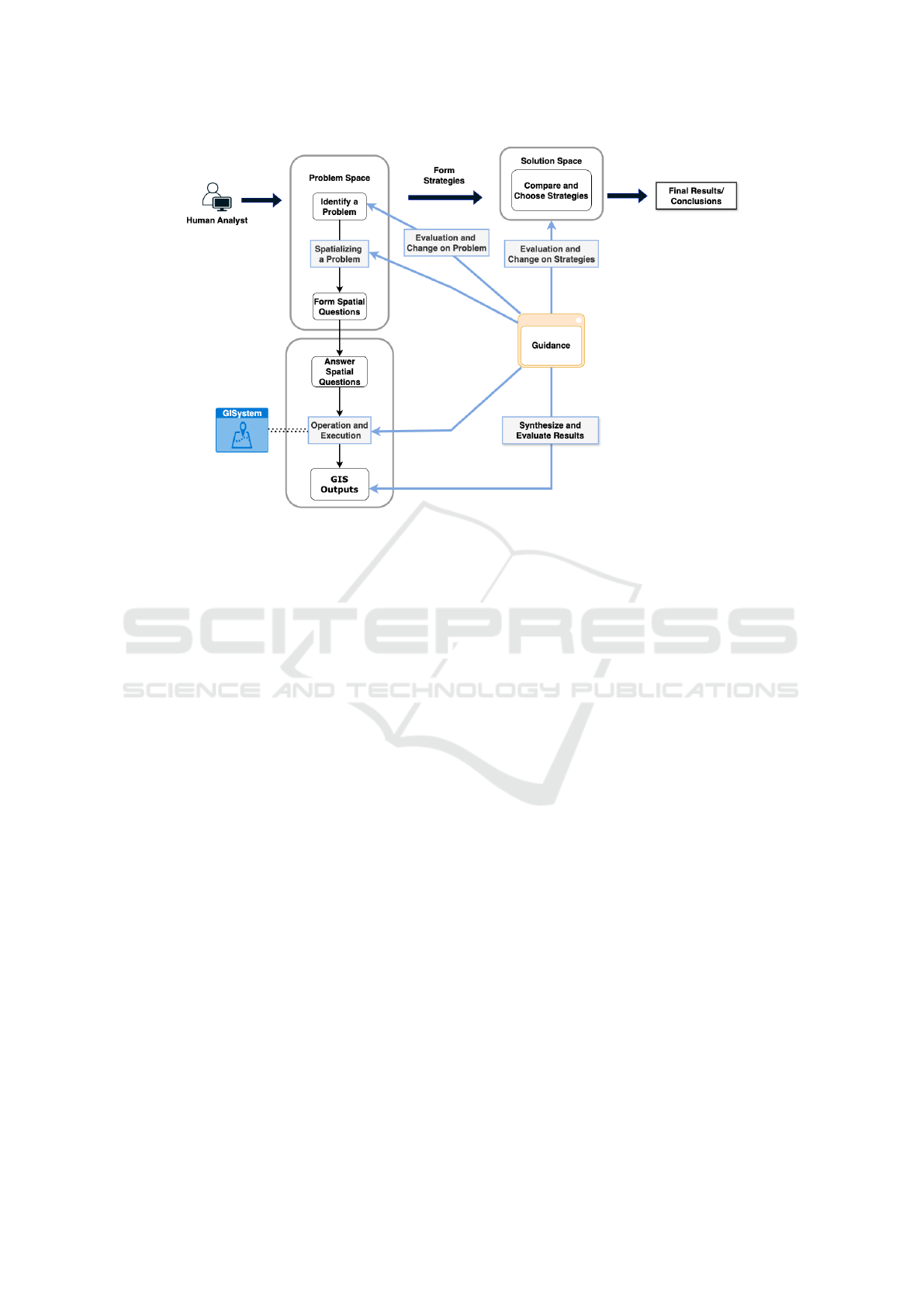
Figure 2: When or where machine guidance can enhance a geospatial analytical workflow (outlined in blue).
provide both high-level analytical strategies and com-
putational support, such as selecting appropriate tools
and parameters (Ceneda et al., 2020). Therefore, the
core challenge in designing effective guidance lies in
accurately identifying analytical difficulties and de-
livering support with appropriate content.
In the following sections, we first identify when
guidance can be needed based on the conceptualized
geospatial analytical process. We then frame and ex-
plain how guidance can be provided in the process. To
demonstrate when and how a human analyst interacts
with and benefits from machine guidance, we present
a hypothetical scenario:
Lucy, a public health promotion analyst, is
working to improve the local food environ-
ment in Wisconsin. Her objective is to iden-
tify counties with limited food access, focus-
ing on those with a high prevalence of food
deserts. Additionally, she aims to prioritize
densely populated counties, as interventions
in these areas would have a greater impact.
With limited state funding, she must strategi-
cally allocate resources to maximize effective-
ness.
Based on this scenario, Table 1 outlines several mo-
ments when guidance can be introduced (MG) along-
side the analyst’s requests and feedback (User).
3.1 When to Provide Guidance
Addressing the question of when guidance is needed,
we propose that timely intervention is essential
whenever analysts face challenges that hinder their
progress. As noted in Figure 2, guidance can be in-
troduced throughout the process from different as-
pects. Particularly, we introduce a conceptual frame-
work that informs the design and development of ma-
chine guidance that operates on three levels:
• Problem-solving Level Guidance helps analysts
spatialize and refine problems. User 1 indi-
cates the analytical goal of understanding the food
shortage conditions so MG 1 provided guidance
by retrieving a dataset representing counties and
food deserts, which offered insights into the cur-
rent food environment in each county. This en-
abled the analyst to develop a foundational un-
derstanding of the phenomenon and prepared the
analyst for subsequent exploratory steps using
the available data. Additionally, analytical goals
may need refinement based on intermediate find-
ings. For instance, the initial problem may be ill-
defined or unrealistic. Guidance can assist ana-
lysts in evaluating their goals and making neces-
sary adjustments.
• Operational Level Guidance supports analysts in
developing GIS workflows and executing specific
spatial functions within a GISsystem. When an-
alysts are uncertain about how to tackle a partic-
ular question, guidance can help construct work-
flows by suggesting appropriate methods and op-
erations. Additionally, if analysts are unfamiliar
with specific tasks, guidance can automate pro-
cesses to abstract operational complexities and
Characterizing Machine Guidance in Geospatial Analysis
43
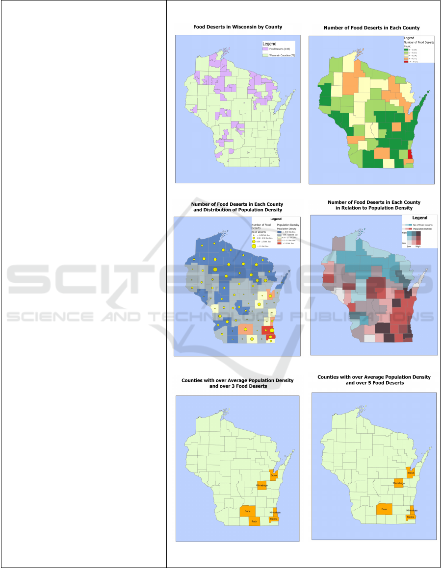
Table 1: Interactions between the Lucy (User) and the machine guidance agent (MG) when assisting her in locating targeted
counties.
Dialogue Guidance Response
User 1: I want to find counties in
Wisconsin with food shortages.
MG 1: Counties in Wisconsin and the
food deserts in the state are presented.
We found 110 food deserts.
User 2: For each county, I need to
know how many food deserts are there.
MG 2: We counted how many food
deserts by county as a measurement.
User 3: I need to find counties with a
large number of food deserts and are
densely populated. How can I do that?
MG 3: We have two strategies. (a)
Manual Selection: You can analyze the
distribution of food desert counts in
relation to population density and
manually select counties that meet
your criteria. While a-1 offers more
flexibility in analyzing each variable
individually, a-2 enhances pattern
recognition by integrating both factors
into a single visual representation,
making it easier to identify areas of
concern at a glance. If the goal is to
detect broad trends and prioritize
interventions efficiently, a-2 is the
preferable choice. However, if a more
detailed breakdown of each factor is
required before drawing conclusions,
a-1 may be more useful. (b)
Automated Selection: We have
identified 6 counties where both the
number of food deserts and the
population density exceed the mean
which may pinpoint areas of interest.
User 4: Strategy (b) results are easier
to follow but I can not deal with all
these counties. How about using more
than 5 food deserts for selection?
MG 4: After adjusting the selection
condition, we found 5 counties.
User 5: I will do more exploration
visually. Thank you.
MG 5: Any other requests? ...
MG 1 MG 2
MG 3 (a)-1 MG 3 (a)-2
MG 3 (b) MG 4
GISTAM 2025 - 11th International Conference on Geographical Information Systems Theory, Applications and Management
44

streamline execution. For instance, User 2 explic-
itly expressed the goal of determining the num-
ber of food deserts in each county, prompting the
guidance system to assist by performing the nec-
essary operations, such as a Spatial Join, to di-
rectly achieve this objective (MG 2). This support
alleviated the analyst’s burden of figuring out how
to obtain the counts and which operations to exe-
cute within the GISystem.
• Strategy Level Guidance aids analysts in devis-
ing and selecting problem-solving strategies. In
MG 3, the guidance offers two different strategies
with three different methods. Multiple solutions
may exist for a given problem, requiring analysts
to simulate different processes and explore “what-
if” scenarios (MG 4) to determine the most suit-
able approach. The guidance agent facilitates this
process by assisting analysts in exploring, evaluat-
ing, and comparing different strategies to identify
the optimal solution.
From another perspective, guidance can be initi-
ated either through explicit requests or by inferring
implicit hints. In MG 1, the system proactively as-
sists the analyst by interpreting the phenomenon as a
starting point, fetching data it deems relevant to the
current analytical goal without requiring explicit in-
put. Instead, it infers the specific data needs based on
the stated objective. In contrast, MG 2 through MG 4
were triggered by the analyst’s direct feedback, where
the guidance responded to explicit requests for assis-
tance regarding their current intention. It ensures that
guidance can take the initiative to help by adapting to
inferred needs as well as meet user-initiated demands,
enhancing human-system collaboration.
3.2 How to Provide Guidance
3.2.1 Guidance in Different Formats
Based on how the guidance is delivered and commu-
nicated to its user, we can categorize the guidance de-
sign based on its output format (P
´
erez-Messina et al.,
2022). Guidance can be offered with:
• Numeric reports and textual information, like
describing what to do next in words or a list of val-
ues. In our scenario, the guidance provides con-
tinuous textual explanations, enabling the analyst
to clearly understand both the ongoing processes
and the specific support being offered by the sys-
tem.
• Visual displays, like showing a map, chart, or
diagram on the screen. With the visual clues,
the user does not need to rely on their memo-
ries or imaginations when scoping their questions.
Throughout MG1 to MG4, the guidance system
generates maps as outputs, enabling the analyst
to visualize spatial patterns and facilitating easier
comparisons. This visual evidence improves the
analyst’s ability to track and advance the analyti-
cal process, ensuring it aligns effectively with the
intended goals.
• Physical operations, like direct operation on the
system end to derive the expected output or an-
swer. In MG2, for instance, the Spatial Join oper-
ation was done as part of the guidance behavior.
• Other formats. Other possible formats like
videos, animations, and audio also can be consid-
ered.
The listed formats are not exclusive from each
other and can be combined to provide more details if
needed. For instance, texts and maps are combined to
guide the analyst in our scenario. In MG3, textual ex-
planation offers hints on how to compare and decide
which strategy can be more suitable. Need to men-
tion that incorporating excessive content into a single
guidance—such as using multiple formats, offering
overly detailed information, or combining too many
elements—can lead to cognitive overload. To en-
sure clarity and usability, guidance should avoid over-
whelming analysts with excessive details that may
hinder their ability to make informed judgments. In-
stead, it should prioritize simplicity and focus on de-
livering concise, relevant information tailored to the
user’s immediate needs.
3.2.2 Guidance in Different Degrees
Degree of guidance means how much assistance is
provided (Ceneda et al., 2019; Ceneda et al., 2016).
The guidance that is orienting or directing the user
has a higher degree of freedom and flexibility com-
pared to prescribing guidance that demonstrates a
fixed solution.
• Orienting guidance orients “where to go”. It
only suggests high-level hints and suggestions. It
is aimed at maintaining users’ current thinking
process (“mental map”) and offering the poten-
tial solutions that can be adopted (Ceneda et al.,
2016). At the problem-solving level, it guides
the user to think about and decide on what is the
proper next step.
• Directing guidance directs “what can be cho-
sen”. It offers concrete recommendations like the
possible options and alternatives that can lead to
desired results (Ceneda et al., 2016). It is more
detailed and concrete than the orienting guidance.
In MG3, the guidance provides two strategies in
Characterizing Machine Guidance in Geospatial Analysis
45

three methods to identify densely populated coun-
ties with a high number of food deserts. By pre-
senting multiple options, it not only offers flexi-
bility but also empowers the analyst to retain con-
trol, allowing them to choose and decide the most
suitable approach for their next steps.
• Prescribing guidance prescribes “what to do”.
It can offer step-by-step directions to solve a
specific problem. Unlike cases where the ana-
lyst is unsure of the next steps, here the analyst
knows the goal but may not know how to achieve
it. This prescriptive process can largely be au-
tomated (Ceneda et al., 2016). For instance, the
process of calculating counts (MG2), and the task
of applying a different selection condition (MG4),
are both automated. This approach conceals the
operational complexities and presents only the fi-
nal outputs.
3.3 Design Challenges and
Opportunities
Designing a computational system capable of provid-
ing effective machine guidance for spatial problem-
solving presents several challenges. One of the pri-
mary difficulties lies in recognizing when and how to
intervene without disrupting the analyst’s workflow.
The assistance should only be provided when it is
genuinely needed and when the analyst is ready to re-
ceive it (Maes, 1995). Otherwise, unnecessary inter-
ruptions could confuse the analyst and interfere with
the analytical process (Ceneda et al., 2020). Detect-
ing the need for assistance can be achieved through
explicit user requests or implicit behavioral moni-
toring, such as tracking user interactions, detecting
recurring difficulties, or even analyzing physiolog-
ical indicators like stress-related facial expressions
(Ceneda et al., 2016; Ceneda et al., 2021). A well-
designed system must balance responsiveness with
non-intrusiveness to ensure a seamless analytical ex-
perience (Maes, 1995).
Another significant computational challenge in-
volves equipping the system with reasoning and plan-
ning capabilities. The system must be able to track
the progress of an analysis, recognize what has been
completed, identify gaps in the current strategy, and
suggest appropriate next steps. This requires integrat-
ing structural knowledge, which enables the system
to monitor and manage analytical workflows (Arm-
strong et al., 1990). Furthermore, a control process
is needed to oversee and guide execution, ensuring
that if an approach fails, alternative solutions can be
explored (Hayes-Roth and Hayes-Roth, 1979). The
system must also infer the analyst’s current stage and
anticipate their information needs, adjusting guidance
accordingly. Recent advancements in Artificial In-
telligence (AI), particularly Large Language Mod-
els (LLMs) and GeoAI, offer promising solutions for
enhancing the design of machine guidance agents.
These technologies can improve the agent’s ability
to interpret user queries, infer analytical goals, and
adaptively learn from user interactions to refine fu-
ture assistance (Li and Ning, 2023). A learning mod-
ule could be integrated to analyze user behavior over
time, helping the system provide more personalized
and context-aware recommendations (Smith et al.,
1987). Leveraging AI-driven techniques can signif-
icantly enhance the effectiveness of computational
guidance systems by making them more intuitive,
adaptive, and capable of supporting complex spatial
analyses.
How to store and represent the required expertise
is another essential challenge. The mentioned ex-
pertise should encompass various types of informa-
tion, including declarative knowledge (basic informa-
tion about spatial and non-spatial objects), procedu-
ral knowledge (strategies for applying spatial opera-
tions), and control knowledge (heuristics for evaluat-
ing the validity of actions and solutions) (Hofer et al.,
2017). The system must be able to intelligently select
and compare spatial operations based on their pur-
pose and suitability for different analytical goals. For
instance, when selecting datasets for Wisconsin, the
representation could vary based on the scale and pur-
pose of analysis, whether as a point on a small-scale
map or as a polygon in a larger-scale map. Knowl-
edge of metadata such as geometry type, spatial ex-
tent, and scale is crucial for ensuring that the correct
datasets are retrieved and applied computationally.
4 DISCUSSION
To ensure the successful implementation of the ma-
chine guidance approach, several critical research
questions must be addressed. First, the conceptual
framework requires further evaluation and refinement.
While our characterizations (Sections 3.1, 3.2) pro-
vide an initial understanding of the machine guidance
approach in geospatial analysis, it remains uncertain
whether they accurately reflect real-world analytical
workflows, the specific challenges analysts face, and
the most effective formats for delivering guidance.
One way to bridge this gap is through observational
studies to examine how analysts approach geospatial
problem-solving in real-world scenarios. Addition-
ally, empirical research is needed to determine the
optimal timing and presentation of guidance to maxi-
GISTAM 2025 - 11th International Conference on Geographical Information Systems Theory, Applications and Management
46

mize its effectiveness. A user-centered approach will
offer valuable insights for designing more intuitive
and effective machine-guided systems.
Secondly, it is computationally challenging to de-
termine when to provide the guidance. Although we
have outlined potential strategies in Section 3.3, their
implementation is still limited, particularly in the con-
text of geospatial analysis. Future research should
explore methods to intelligently recognize the need
for guidance, ensuring that it is provided in a timely
and non-disruptive manner. This could involve devel-
oping adaptive systems that learn from user behavior
and context to offer guidance only when it is most
beneficial.
Third, ensuring the scalability of the expertise
embedded within the guidance while maintaining its
specificity across diverse domains is critical. This
raises important questions about what information or
knowledge should be captured, how it should be rep-
resented, and the level of detail required to balance
generality and domain-specific relevance. Addressing
these questions is essential for creating guidance sys-
tems that are both adaptable to a wide range of appli-
cations and sufficiently detailed to provide meaning-
ful support in specialized contexts. Future research
should explore methods for capturing and structuring
domain knowledge in a way that ensures scalability
without sacrificing precision and ultimately ensures
machine guidance applications are effective across
various analytical domains.
To sum up, our study is to establish proof-
of-concept design principles for machine guidance.
While we have identified various design opportu-
nities, our work remains at the conceptual stage
and lacks computational implementation and prac-
tical evaluation. Future efforts are needed to de-
velop concrete computational frameworks for ma-
chine guidance and to conduct empirical evaluations.
Implementing these systems in real-world applica-
tions will provide valuable insights through user feed-
back, which can help refine and validate the proposed
design features. Addressing the mentioned challenges
will not only advance the field of machine-guided
geoanalytical systems but also pave the way for
broader applications in other domains where human-
machine collaboration is critical.
5 CONCLUSIONS
We propose using machine guidance as a new ap-
proach to support analysts’ geospatial analytical pro-
cess. As a complex and mentally demanding en-
deavor, geospatial analysis poses a significant chal-
lenge for individuals with limited GIS knowledge and
experience. This challenge highlights the importance
of machine guidance, which encapsulates reasoning
and processing steps within the system itself, allow-
ing analysts to focus on interpreting analytical outputs
rather than navigating complex workflows.
As a starting point, we characterized a conceptual
framework focusing on (1) when guidance should be
introduced and (2) how guidance can be delivered to
help the analyst. Specifically, our approach suggests
that machine guidance should be placed when the user
meets difficulties when doing geospatial analysis. At
these moments, users may struggle with decision-
making due to the need for extensive mental effort, of-
ten lacking sufficient knowledge or expertise to solve
the issue at hand. Using the hypothetical scenario, we
presented various machine guidance that are in differ-
ent degrees and formats.
To the best of our knowledge, this research marks
the first attempt to integrate machine guidance into
GISystems, with the potential to drive advancements
in the broader field of GIScience. As an initial ef-
fort, this study introduces the concept of the machine
guidance approach in supporting geospatial analysis
as well as its design opportunities and potential. Our
ongoing efforts are focused on refining these guid-
ance design strategies and evaluating their feasibil-
ity in real-world scenarios. We seek to foster further
academic discussion and social engagement around
the role of machine guidance in facilitating geospa-
tial analysis. Ultimately, we hope this work sparks
further investigation and encourages the development
of innovative approaches along the way.
REFERENCES
Ahasan, R. and Hossain, M. M. (2021). Leveraging gis
and spatial analysis for informed decision-making in
covid-19 pandemic. Health policy and technology,
10(1):7.
Armstrong, M., De, S., Densham, P., Lolonis, P., Rushton,
G., and Tewari, V. K. (1990). A knowledge-based
approach for supporting locational decisionmaking.
Environment and Planning B: Planning and Design,
17(3):341–364.
Baars, B. J. (1997). Some essential differences between
consciousness and attention, perception, and working
memory. Consciousness and cognition, 6(2-3):363–
371.
Baddeley, A. (1992). Working memory: The interface be-
tween memory and cognition. Journal of cognitive
neuroscience, 4(3):281–288.
Badea, A.-C. and Badea, G. (2013). The advantages of
creating compound gis functions for automated work-
Characterizing Machine Guidance in Geospatial Analysis
47

flow. International Multidisciplinary Scientific Geo-
Conference: SGEM, 1:943.
Bailey, T. C., Gatrell, A. C., et al. (1995). Interactive spa-
tial data analysis, volume 413. Longman Scientific &
Technical Essex.
Bednarz, S., Heffron, S., and Huynh, N. (2013). A road map
for 21st century geography education. Washington,
DC: Association of American Geographers.
Bednarz, S. W. (2004). Geographic information systems: A
tool to support geography and environmental educa-
tion? GeoJournal, 60:191–199.
Ceneda, D., Andrienko, N., Andrienko, G., Gschwandtner,
T., Miksch, S., Piccolotto, N., Schreck, T., Streit, M.,
Suschnigg, J., and Tominski, C. (2020). Guide me
in analysis: A framework for guidance designers. In
Computer Graphics Forum, volume 39, pages 269–
288. Wiley Online Library.
Ceneda, D., Arleo, A., Gschwandtner, T., and Miksch, S.
(2021). Show me your face: towards an automated
method to provide timely guidance in visual analyt-
ics. IEEE Transactions on Visualization and Com-
puter Graphics, 28(12):4570–4581.
Ceneda, D., Gschwandtner, T., May, T., Miksch, S., Schulz,
H.-J., Streit, M., and Tominski, C. (2016). Character-
izing guidance in visual analytics. IEEE transactions
on visualization and computer graphics, 23(1):111–
120.
Ceneda, D., Gschwandtner, T., May, T., Miksch, S., Streit,
M., and Tominski, C. (2018). Guidance or no guid-
ance? a decision tree can help. In EuroVA@ EuroVis,
pages 19–23.
Ceneda, D., Gschwandtner, T., and Miksch, S. (2019). A
review of guidance approaches in visual data analy-
sis: A multifocal perspective. In Computer Graphics
Forum, volume 38, pages 861–879. Wiley Online Li-
brary.
Cohen, P. R., Johnston, M., McGee, D., Oviatt, S., Pittman,
J., Smith, I., Chen, L., and Clow, J. (1997). Quickset:
Multimodal interaction for distributed applications. In
Proceedings of the fifth ACM international conference
on Multimedia, pages 31–40.
Collins, C., Andrienko, N., Schreck, T., Yang, J., Choo, J.,
Engelke, U., Jena, A., and Dwyer, T. (2018). Guid-
ance in the human–machine analytics process. Visual
Informatics, 2(3):166–180.
Couclelis, H. (2003). The certainty of uncertainty: Gis and
the limits of geographic knowledge. Transactions in
GIS, 7(2):165–175.
Council, N. R. et al. (2005). Learning to think spatially.
Creem-Regehr, S. H., Willemsen, P., Gooch, A. A., and
Thompson, W. B. (2005). The influence of restricted
viewing conditions on egocentric distance perception:
Implications for real and virtual indoor environments.
Perception, 34(2):191–204.
Curtis, J. W. (2012). Integrating sketch maps with gis to ex-
plore fear of crime in the urban environment: A review
of the past and prospects for the future. Cartography
and Geographic Information Science, 39(4):175–186.
De Smith, M. J., Goodchild, M. F., and Longley, P. (2007).
Geospatial analysis: a comprehensive guide to prin-
ciples, techniques and software tools. Troubador pub-
lishing ltd.
D
¨
orner, D. and Kreuzig, H. W. (1983). Prob-
leml
¨
osef
¨
ahigkeit und intelligenz. Psychologische
Rundschau.
Downs, R. M. (1997). The geographic eye: Seeing through
gis? 1. Transactions in GIS, 2(2):111–121.
Downs, R. M., Liben, L. S., and Daggs, D. G. (1988).
On education and geographers: The role of cogni-
tive developmental theory in geographic education.
Annals of the Association of American Geographers,
78(4):680–700.
Dramowicz, K., Wightman, J. F., and Crant, J. S. (1993).
Addressing gis personnel requirements: A model for
education and training. Computers, Environment and
Urban Systems, 17(1):49–59.
Dungan, J. L., Perry, J., Dale, M., Legendre, P., Citron-
Pousty, S., Fortin, M.-J., Jakomulska, A., Miriti, M.,
and Rosenberg, M. (2002). A balanced view of scale
in spatial statistical analysis. Ecography, 25(5):626–
640.
Fischer, A., Greiff, S., and Funke, J. (2011). The process of
solving complex problems. Journal of Problem Solv-
ing, 4(1):19–42.
Freksa, C., Barkowsky, T., Dylla, F., Falomir, Z., Oltet¸eanu,
A.-M., and van de Ven, J. (2017). Spatial problem
solving and cognition. In Representations in mind and
world, pages 156–183. Routledge.
Gao, S. and Goodchild, M. F. (2013). Asking spatial ques-
tions to identify gis functionality. In 2013 Fourth In-
ternational Conference on Computing for Geospatial
Research and Application, pages 106–110. IEEE.
Goodchild, M. and Longley, P. (1999). The future of gis and
spatial analysis. Geographical information systems,
1:567–580.
Goodchild, M. F. (1992). Geographical information sci-
ence. International journal of geographical informa-
tion systems, 6(1):31–45.
Goodchild, M. F. (2000). Part 1 spatial analysts and gis
practitioners: The current status of gis and spatial
analysis. Journal of Geographical Systems, 2:5–10.
Goodchild, M. F. (2006). The fourth r? rethinking gis edu-
cation. ESRI ArcNews, 28(3):1.
Goodchild, M. F. (2009). Geographic information systems
and science: Today and tomorrow. Annals of GIS,
15(1):3–9.
Goodchild, M. F., Anselin, L., Appelbaum, R. P., and
Harthorn, B. H. (2000). Toward spatially integrated
social science. International Regional Science Re-
view, 23(2):139–159.
Goodchild, M. F. and Janelle, D. G. (2010). Toward critical
spatial thinking in the social sciences and humanities.
GeoJournal, 75:3–13.
Grekousis, G. (2020). Spatial analysis methods and prac-
tice: describe–explore–explain through GIS. Cam-
bridge University Press.
Haining, R. (1994). Designing spatial data analysis modules
for geographical information systems. Spatial analy-
sis and GIS, pages 45–64.
GISTAM 2025 - 11th International Conference on Geographical Information Systems Theory, Applications and Management
48

Hayes-Roth, B. and Hayes-Roth, F. (1979). A cognitive
model of planning. Cognitive science, 3(4):275–310.
Hofer, B., M
¨
as, S., Brauner, J., and Bernard, L. (2017).
Towards a knowledge base to support geoprocessing
workflow development. International Journal of Ge-
ographical Information Science, 31(4):694–716.
Huisman, O., de By, R. A., et al. (2009). Principles of ge-
ographic information systems. ITC Educational Text-
book Series, 1:17.
Johnson, A. B. and Sullivan, D. (2010). Geospatial edu-
cation at us community colleges: Background, chal-
lenges, and opportunities. Journal of the Urban &
Regional Information Systems Association, 22(2).
Kang, J.-Y., Michels, A., Lyu, F., Wang, S., Agbodo, N.,
Freeman, V. L., and Wang, S. (2020). Rapidly mea-
suring spatial accessibility of covid-19 healthcare re-
sources: a case study of illinois, usa. International
journal of health geographics, 19:1–17.
Kendoul, F. (2012). Survey of advances in guidance, nav-
igation, and control of unmanned rotorcraft systems.
Journal of Field Robotics, 29(2):315–378.
Kruiger, J. F., Kasalica, V., Meerlo, R., Lamprecht, A.-L.,
Nyamsuren, E., and Scheider, S. (2021). Loose pro-
gramming of gis workflows with geo-analytical con-
cepts. Transactions in GIS, 25(1):424–449.
Kurland, K. S. and Gorr, W. L. (2007). GIS tutorial for
health. ESRI, Inc.
Li, M., Imou, K., Wakabayashi, K., and Yokoyama, S.
(2009). Review of research on agricultural vehicle au-
tonomous guidance. International Journal of Agricul-
tural and biological engineering, 2(3):1–16.
Li, Z. and Ning, H. (2023). Autonomous gis: the next-
generation ai-powered gis. International Journal of
Digital Earth, 16(2):4668–4686.
Lieberman, H., Fry, C., and Rosenzweig, E. (2015). The
New Era of High-Functionality Interfaces. In Duval,
B., Van Den Herik, J., Loiseau, S., and Filipe, J., edi-
tors, Agents and Artificial Intelligence, volume LNAI
8946, pages 3–10. Springer International Publishing,
Cham.
Lim, K. J., Engel, B. A., Tang, Z., Choi, J., Kim, K.-S.,
Muthukrishnan, S., and Tripathy, D. (2005). Auto-
mated web gis based hydrograph analysis tool, what
1. JAWRA Journal of the American Water Resources
Association, 41(6):1407–1416.
Liu, S., Andrienko, G., Wu, Y., Cao, N., Jiang, L., Shi, C.,
Wang, Y.-S., and Hong, S. (2018). Steering data qual-
ity with visual analytics: The complexity challenge.
Visual Informatics, 2(4):191–197.
Maes, P. (1995). Agents that reduce work and information
overload. In Readings in human–computer interac-
tion, pages 811–821. Elsevier.
Miller, H. J. and Wentz, E. A. (2003). Representation and
spatial analysis in geographic information systems.
Annals of the Association of American Geographers,
93(3):574–594.
Mollalo, A., Mohammadi, A., Mavaddati, S., and Kiani, B.
(2021). Spatial analysis of covid-19 vaccination: a
scoping review. International journal of environmen-
tal research and public health, 18(22):12024.
Nyerges, T. L. (1995). Cognitive issues in the evolution of
gis user knowledge. In Cognitive aspects of human-
computer interaction for geographic information sys-
tems, pages 61–74. Springer.
P
´
erez-Messina, I., Ceneda, D., El-Assady, M., Miksch, S.,
and Sperrle, F. (2022). A typology of guidance tasks
in mixed-initiative visual analytics environments. In
Computer Graphics Forum, volume 41, pages 465–
476. Wiley Online Library.
Perry, J., Liebhold, A., Rosenberg, M., Dungan, J., Mir-
iti, M., Jakomulska, A., and Citron-Pousty, S. (2002).
Illustrations and guidelines for selecting statistical
methods for quantifying spatial pattern in ecological
data. Ecography, 25(5):578–600.
Pretz, J. E., Naples, A. J., and Sternberg, R. J. (2003). Rec-
ognizing, defining, and representing problems. The
psychology of problem solving, 30(3):3–30.
Ram
´
ırez, I. J. and Lee, J. (2020). Covid-19 emergence and
social and health determinants in colorado: a rapid
spatial analysis. International journal of environmen-
tal research and public health, 17(11):3856.
Roche, S. (2014). Geographic information science i:
Why does a smart city need to be spatially enabled?
Progress in Human Geography, 38(5):703–711.
Rogers, Y. (2004). New theoretical approaches for hci. An-
nual review of information science and technology,
38(1):87–143.
Scheider, S., Ballatore, A., and Lemmens, R. (2019). Find-
ing and sharing gis methods based on the questions
they answer. International journal of digital earth,
12(5):594–613.
Scheider, S., Nyamsuren, E., Kruiger, H., and Xu, H.
(2021). Geo-analytical question-answering with gis.
International Journal of Digital Earth, 14(1):1–14.
Schulze, U. (2021). “gis works!”—but why, how, and for
whom? findings from a systematic review. Transac-
tions in GIS, 25(2):768–804.
Shin, E. E., Milson, A. J., and Smith, T. J. (2016). Future
teachers’ spatial thinking skills and attitudes. Journal
of Geography, 115(4):139–146.
Slocum, T. A., Blok, C., Jiang, B., Koussoulakou, A.,
Montello, D. R., Fuhrmann, S., and Hedley, N. R.
(2001). Cognitive and usability issues in geovisual-
ization. Cartography and geographic information sci-
ence, 28(1):61–75.
Smith, T., Peuquet, D., Menon, S., and Agarwal, P. (1987).
Kbgis-ii a knowledge-based geographical information
system. International Journal of Geographical Infor-
mation System, 1(2):149–172.
Sperrle, F., Ceneda, D., and El-Assady, M. (2022). Lotse:
A practical framework for guidance in visual analyt-
ics. IEEE Transactions on Visualization and Com-
puter Graphics, 29(1):1124–1134.
Sun, F., Matthews, S. A., Yang, T.-C., and Hu, M.-H.
(2020). A spatial analysis of the covid-19 period
prevalence in us counties through june 28, 2020:
where geography matters? Annals of epidemiology,
52:54–59.
Terveen, L. G. (1995). Overview of human-computer col-
laboration. Knowledge-Based Systems, 8(2-3):67–81.
Characterizing Machine Guidance in Geospatial Analysis
49

Thomas, J. J. (2005). Illuminating the path:the research
and development agenda for visual analytics. IEEE
Computer Society.
Traynor, C. (1998). Putting power in the hands of end users:
a study of programming by demonstration, with an ap-
plication to geographical information systems. In CHI
98 conference summary on Human factors in comput-
ing systems, pages 68–69.
Verma, K. and Estaville, L. (2018). Role of geography
courses in improving geospatial thinking of under-
graduates in the united states. International Journal
of Geospatial and Environmental Research, 5(3):2.
Wang, Q., Chen, Z., Wang, Y., and Qu, H. (2021). A sur-
vey on ml4vis: Applying machinelearning advances
to data visualization. IEEE Transactions on Visual-
ization and Computer Graphics.
Ward, T. B., Smith, S. M., and Finke, R. A. (1999). Creative
cognition. Handbook of creativity, 189:212.
Yeo, I.-A. and Yee, J.-J. (2016). Development of an auto-
mated modeler of environment and energy geographic
information (e-gis) for ecofriendly city planning. Au-
tomation in Construction, 71:398–413.
GISTAM 2025 - 11th International Conference on Geographical Information Systems Theory, Applications and Management
50
