
Modelling the Road Network as an Expression of Historical Spatial
System Change in the Klaipeda Region (Lithuania)
Thomas Gloaguen
1,2 a
, Kęstutis Zaleckis
1b
and Sébastien Gadal
2c
1
Cultural and Spatial Environment Research Group, Faculty of Civil Engineering and Architecture,
Kaunas University of Technology, 51367 Kaunas, Lithuania
2
UMR 7300 ESPACE, CNRS, Aix-Marseille Université, Université Côte-d’Azur, Avignon Université,
84029 Avignon, France
Keywords: Spatial System, Network Structures, Generic City Concept, Space Syntax, Spatiotemporal Modelling,
Lithuania.
Abstract: Since the 20
th
century, the Klaipėda region (Lithuania) has undergone significant political, economic, social,
and cultural changes related to the disappearance of Prussia (1923), the Soviet occupation (1944) and the
restoration of independence (1991). This has led to radical transformations in the spatial system, of which the
road network is a key component. Networks could be analysed using space syntax methods by assimilating
them to a mathematical graph model, for which quantitative indexes based on topology can be applied to
assess their spatial configurations. The ‘Generic City’ approach, by simulating foreground and background
urban networks, can be modified innovatively on a territorial scale. Based on historical cartographies and
open geographic databases, indexes characterising both networks are derived to describe the length, angularity
or accessibility of the pre-Soviet, Soviet and post-Soviet networks. The analysis identified four main spatial
structures associated with the network by combining the indexes in a K-means machine learning algorithm.
They highlight the spatial impacts of collectivisation, industrialisation, and tertiarisation of the economy, post-
World Wars and post-Cold War geopolitical events, and their consequences as drivers of the territorial
organisation and dynamics such as the metropolisation or peri-urbanisation.
1 INTRODUCTION
Since the 20
th
century, the coastal region of Klaipėda
in Lithuania has undergone significant and rapid
transformations. These changes were initially
political, with the territory being divided between the
Kingdom of Prussia and the Russian Empire,
experiencing a brief period of independence during
the interwar years, being incorporated into the Union
of Soviet Socialist Republics (USSR) in 1944, and
finally seeing the restoration of independence in 1991
(Plakans, 2011). These geopolitical shifts have been
accompanied by economic, social, cultural, and
societal changes, including agrarian reforms such as
agrarian capitalism and collectivisation (Jespen et al.,
2015), urban expansion, particularly suburban sprawl
(Cirtautas, 2015), Soviet industrialisation, and the
a
https://orcid.org/0000-0003-1849-9615
b
https://orcid.org/0000-0001-9223-9956
c
https://orcid.org/0000-0002-6472-9955
subsequent deindustrialisation and tertiarisation after
the Soviet era (Idzelis, 1984; Köll, 2024), alongside
recent trends of population decline and migration
(Ubarevičienė and Van Ham, 2017), throughout the
20
th
and early 21
st
centuries.
The organisation of geographic space is
significantly influenced by societal changes, whether
directly or indirectly. The analysis of these territorial
transformations is rooted in the concept of spatial
systems, which refers to the distribution (structures)
of geographical entities — such as built environments,
road networks, land use, land cover, and land parcels
— in space according to either spontaneous or
regulated logics (Archaeomedes, 1998; Allain, 2004;
Ellisalde, 2004).
The objective of this research is to examine the
evolution of the spatial system in the Klaipėda region
Gloaguen, T., Zaleckis, K. and Gadal, S.
Modelling the Road Network as an Expression of Historical Spatial System Change in the Klaipeda Region (Lithuania).
DOI: 10.5220/0013249600003935
Paper published under CC license (CC BY-NC-ND 4.0)
In Proceedings of the 11th International Conference on Geographical Information Systems Theory, Applications and Management (GISTAM 2025), pages 61-72
ISBN: 978-989-758-741-2; ISSN: 2184-500X
Proceedings Copyright © 2025 by SCITEPRESS – Science and Technology Publications, Lda.
61

(Lithuania) since the 20
th
century. To achieve this
objective, the road network has been modelled using
space syntax methods, with a particular focus on the
‘Generic City’ concept.
The analysis of spatial systems involves
examining their structural complexity, which
includes the participation of multiple agents; spatial
complexity characterised by various geographical
scales; and temporal complexity marked by non-
linear evolutions (Badariotti, 2005). Spatial analysis
and modelling offer methodologies for
comprehending the intricacies of spatial systems by
translating geographical reality into mathematical
forms (Georges and Verger, 2013). This
methodological approach has been employed to
describe “[…] the distribution, configuration and
covariation” of geographical objects in space”
(Voiron-Canicio, 1995).
In complex spatial systems, networks facilitate the
relationships between various points of attraction and
diffusion, such as urban centres (Georges and Verger,
2013). The mathematical graph model serves as the
theoretical basis for space syntax, wherein networks
are represented by nodes corresponding to the
network segments and links connecting these nodes.
This theoretical framework enables the simulation of
interrelationships between spatial configurations and
their associated urban functions (Laouar and
Manzouz, 2017; Abida, 2018). Syntactic indexes
based on the topology of network segments are
utilised to examine how spatial structure influences
human behaviour through simulated movement.
This research focuses on the Klaipėda region,
where spatial changes are particularly pronounced
compared to the rest of Lithuania. The unique
environment of this coastal area is attributable to its
position as a maritime interface. During the Soviet era,
the port of Klaipėda emerged as a pivotal facilitator
of connectivity between the Baltic and the Black Sea
regions, driving the development of strategic
economic activities alongside the growth of seaside
tourism. Despite the region experiencing partial
militarisation during this period, Lithuania’s
independence in the 1990s led to the enhancement of
these activities and an opening to the market economy.
A consequence of this transformation has been the
rapid suburbanisation of the metropolitan and coastal
areas that began in the 2000s (Vaitkus and
Vaikuvienė, 2005; Veteikis et al., 2011; Cirtautas,
2015). Furthermore, the region is historically divided
between two ethnographic areas: Samogitia
(Žemaitija) in the north and Lithuania Minor (Mažoji
Lietuva) in the south, each exhibiting distinct
functional and cultural characteristics (Ragauskaitė,
2019). The former corresponds to the territory that
was under Russian occupation, while the latter was
incorporated into Prussia prior to the Soviet era.
2 THE ‘GENERIC CITY’
CONCEPTUAL APPROACH
This analysis draws upon the concept of the ‘Generic
City’, developed within space syntax theories and
methodologies to identify the spatial and functional
similarities between cities despite their diverse
cultural contexts (Hillier, 2007; Hillier, 2010).
This concept proposes that each city exhibit a dual
network characterised by (1) “longer lines and nearly
straight connections”, indicating a foreground
network, and (2) “shorter lines with more near right
angle connections, and so more localised and with
less linear continuity”, referring to a background
network.
The foreground network tends to be similar across
various cities, while the background network is more
specific and sensitive to cultural context. These
networks, with their distinct physical and functional
attributes, are evaluated using specific indexes
(section 3.2).
For instance, Al Sayed (2009) compared the
foreground and background networks of Manhattan
and Barcelona to showcase the emergence of dynamic
and adaptive urban networks. In the present study,
however, the indexes traditionally used to
characterise these networks are applied not in an
urban context but in a territorial one. They prove to
be insufficiently suited to the research objectives due
to their low statistical reliability and limited
differentiation between foreground and background
networks. The diversity of urban and rural settlements
(including individual and familial farms, villages,
towns, and cities) in relation to road networks
presents varying degrees of appeal for movements
across the territory (Dringelis, 2015). Furthermore,
the region has been shaped by multiple cultural
influences — Prussian, Russian, Soviet, and post-
Soviet — which have successively affected territorial
organisation, complicating the modelling of these
networks. Consequently, it has become essential to
employ syntactic indexes that more accurately reflect
the conceptual approach of the Generic City in a
territorial context (Gloaguen et al., 2023).
GISTAM 2025 - 11th International Conference on Geographical Information Systems Theory, Applications and Management
62

3 SYNTACTIC TERRITORIAL
INDEXES FOR
SPATIOTEMPORAL
MODELLING OF NETWORK
STRUCTURES
3.1 Data Acquisition
The present analysis adopts a historical retrospective
approach, necessitating the identification of
representative analytical periods that reflect differing
political, economic, social, and cultural contexts.
According to the scientific literature and the
conceptualisations proposed by some Lithuanian
researchers regarding the urban structures of Baltic
cities (Cirtautas, 2013) and rural settlements and
landscapes (Bučas, 2001), three primary recurring
periods are typically used for analysing the 20
th
and
21
st
centuries: the pre-Soviet (before 1945), the
Soviet (1945-1990), and the post-Soviet (after 1990).
The selection of these periods is also influenced
by the availability of cartographic data. Historical
cartographic resources are utilised for both pre-Soviet
and Soviet periods. Piškinaitė and Veteikis (2023)
note that cartographic materials are still underutilised
by researchers in Lithuania. For the initial period, the
series ‘Karte des Deutschen Reiches’ (Map of the
German Reich, 1870-1944) and ‘Karte des
Westlichen Russlands’ (Map of Western Russia,
1892-1921) are employed, both at a resolution of
1:100,000. For the subsequent period, Soviet military
topographic maps from 1985 at a resolution of
1:50,000 are used. The choice of these series is
predicated on several criteria, including their free
availability, the quality of their scanning, and the
inclusion of a legend for analysis and digitisation
purposes.
For the latest recent period (2023), free
geographic data from OpenStreetMap
(https://www.openstreetmap.org/) was extracted
using the ‘Over Pass Turbo’ tool (https://overpass-
turbo.eu/). Barrington-Leigh and Millard-Ball (2017)
estimate the completeness fraction of the
OpenStreetMap road network in Lithuania is
approximately 97% reflecting the accuracy of the
information compared to actual conditions.
The interactive, manually digitised data was then
processed to exclude unwanted networks, such as
footpaths, cycle paths, and occasionally utilised roads
like forest tracks. This process also involved the
removal of duplicate and isolated lines, as well as a
check for their connectivity.
3.2 ‘Generic City’ Indexes Adapted to
Territorial Analysis
The indexes are derived from the theoretical
framework that treats the network as a mathematical
graph, where nodes represent network segments and
links signify the connections between them.
Quantitative methodologies that prioritise the
topology of these segments are employed to assess
various spatial configurations, including centrality,
connectivity, accessibility, and movement.
Four indexes from the Spatial Network Analysis
Software (sDNA) library (https://sdna.cardiff.ac.uk/
sdna/) are utilised to characterise the foreground and
background networks (Cooper and Chiaradia, 2020;
Cooper, 2024). These indexes were initially chosen
based on experiments conducted in the same study
area, where their correlation with human activity data
— such as population density, amenities, and light
pollution — was assessed. The observed correlation
coefficients, which range from 0.61 to 0.74 on
average, reflect strong to extraordinarily strong
relationships, making them relevant for the analysis
(Gloaguen et al., 2022).
For the background network indexes, a radius of
1000 metres is applied to simulate local network
behaviour.
The Network Quantity Penalized by Distance
(NQPD) index is computed for both foreground and
background networks. This index quantifies the
number of accessible segments (network quantity)
within a specified radius of a given segment (equation
1). Each segment is regarded as equally attractive,
thereby allowing the focus to be solely on distance.
𝑁𝑄𝑃𝐷(𝑥) =
(𝑊
(
𝑦
)
𝑃
(
𝑦
)
)
𝑑
(𝑥,𝑦)
∈
(1)
Where,
𝑅
is the set of polylines in the network radius
from the link 𝑥.
𝑊(𝑦) is the weight of a polyline 𝑦.
𝑃(𝑦) is the proportion of any polyline 𝑦
within the radius.
𝑑
(𝑥,𝑦) is the distance according to a metric
𝑀 along a geodesic defined by 𝑀, between an
origin polyline 𝑥 and a destination polyline 𝑦.
𝑛𝑞𝑝𝑑𝑛 and 𝑛𝑞𝑝𝑑𝑑 are the numerator and
denominator of NQPD, usually defined as 1.
The NQPD index emphasises the most accessible
areas of the network, which often align with the urban
central zone, characterised by high
multifunctionality.
Modelling the Road Network as an Expression of Historical Spatial System Change in the Klaipeda Region (Lithuania)
63

Three indexes are exclusively used to describe the
background network. First, the ‘Length’ index (LEN)
quantifies the cumulative length of segments within a
specified radius (equation 2).
𝐿𝐸𝑁 = 𝐿
(
𝑦
)
𝑃(𝑦)
∈
(2)
Where,
𝑅
is the set of polylines in the network radius
from the link 𝑥.
𝐿(𝑦) is the Euclidean length of polyline 𝑦.
𝑃(𝑦) is the proportion of any polyline 𝑦
within the radius.
This index can be likened to Peponis’s (2008)
‘Metric Reach’ index, as it underscores the physical
extent of connections and assesses the utilisation of
network areas.
Second, the ‘Angular Distance’ index (ANG)
captures the total angular curvature of segments
within the radius (equation 3).
𝐴
𝑁𝐺 = 𝑑
(𝑦
)
∈
(3)
Where,
𝑅
is the set of polylines in the network radius
from the link 𝑥.
𝑑
is the cumulative angular curvature along
the full length of the line in degrees.
𝑦
is the proportion of 𝑦 that falls within the
radius only.
Unlike the Length index, this index focuses solely
on closeness (geometrical proximity) and does not
account density.
Finally, the ‘Betweenness’ index (BT) (equation
4) assesses the frequency with which a segment
appears in the shortest paths connecting other
segments within a designated radius.
𝐵𝑇
(
𝑥
)
=𝑊
(
𝑦
)
𝑊
(
𝑧
)
𝑃
(
𝑧
)
𝑂𝐷
(
𝑦,𝑧,𝑥
)
∈
∈
(4)
Where,
𝑁 is the set of polylines in the global spatial
system.
𝑅
is the set of polylines in the network radius
from the link 𝑦.
𝑊(𝑦) and 𝑊(𝑧) are the weight of the
geodesic endpoints 𝑦 and 𝑧.
𝑃(𝑧) is the proportion of any polyline 𝑧 within
the radius.
𝑂𝐷(𝑦,𝑧,𝑥) are the geodesic paths between 𝑦
and 𝑧 that pass through a vertex 𝑥.
The Betweenness index reflects transit
movements, highlighting the key segments of the
network.
All indexes are standardised by dividing their
value by the standard deviation, which enables
comparisons across networks of varying sizes.
Standardisation also accommodates the spatial
resolutions of the geographic data utilised over
different periods.
3.3 Machine Learning Modelling of the
Spatial Structures of the Network
To identify the principal spatial structures associated
with the networks and their evolution over time, the
foreground and background indexes are integrated for
multivariate analysis.
The networks are overlaid on a 1km-by-1km grid,
and the average values of each index are calculated.
The grid size corresponds to the radius value used for
the background network indexes. However, it is
crucial to note that the selected grid size influences
the interpretation of results, as does the number of
clusters.
A multivariate analysis was conducted using a K-
means algorithm to minimise the variance of values
grouped into clusters. Effectively generalise and
visualise the results of the indexes, the number of
clusters was established at four. Each cluster
represents a spatial structure of the road network that
corresponds to the territorial organisation,
comparable both in time and space.
4 EVOLUTIONS OF
FOREGROUND AND
BACKGROUND NETWORKS
The foreground network has experienced
considerable evolution over time. As illustrated in
Figure 1, the centre of gravity of the network is
gradually shifting from the south during the pre-
Soviet period to the centre of the coastal region in the
post-Soviet period. The NQPD index indicates a
decline in regional accessibility of the network over
time, with average standardised values of 6.19 for the
pre-Soviet network, 5.24 for the Soviet network, and
4.22 for the post-Soviet network.
At the local level, two trends emerge: a decrease
in the NQPD index from the pre-Soviet (1.06) to
Soviet (0.94) periods, followed by an increase
between the Soviet and post-Soviet periods (1.20)
(Figure 2). These findings suggest a densification and
GISTAM 2025 - 11th International Conference on Geographical Information Systems Theory, Applications and Management
64
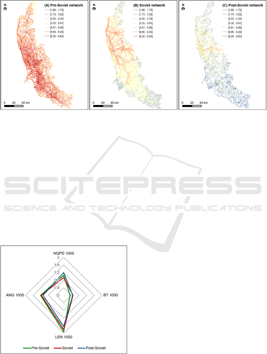
Figure 1: Spatial evolution of the foreground network between the (a) pre-Soviet, (b) Soviet, and (c) post-Soviet periods.
local expansion of the network, a trend also noted by
Strano et al. (2012) in their analysis of network
evolution in the suburbs of Milan. Notably, the
suburbs of Klaipėda witnessed significant
densification between the Soviet and post-Soviet
periods.
The Length and Angular Distance indexes, which
measure the potential for social interactions and the
organicity of the local networks, respectively, have
shown a decrease in their standardised values over
time. The average value for Length in the post-Soviet
period is 1.64, compared to 1.80 for the Soviet period
and 1.93 for the pre-Soviet period (Figure 2).
Regarding Angular Distance, the average value for
the post-Soviet period stands at 1.08, in contrast to
1.17 for the Soviet period and 1.21 for the pre-Soviet
period (Figure 2).
Figure 2: Quantitative evolution of background network
indexes.
The betweenness index, which highlights the
significance of a segment within the local network,
shows an increase in the average standardised values
from the pre-Soviet (0.33) to the Soviet period (0.49),
followed by a stabilisation between the Soviet and
post-Soviet periods (0.47) (Figure 2). This increase in
betweenness values suggests that the hierarchy
among routes is becoming more clearly defined over
time at the local level.
5 HIERARCHY AND DYNAMICS
OF NETWORK STRUCTURES
By integrating the foreground network and
background network indexes into a multivariate
analysis, the primary spatial structures of the
Klaipėda region’s spatial system are identified. These
structures are characterised by (1) the key local
centralities, (2) the territorial centre of gravity, (3)
secondary centralities in transition and (4) peripheral
areas. Their respective evolution is interpreted in
relation to existing scientific literature.
5.1 Main Local Centres
The first spatial structure is linked to grid tiles that
possess the highest average indexes, irrespective of
the type of network (Figure 3).
These grid tiles represent the main local
centralities within the network. Between the pre-
Soviet and post-Soviet periods, the networks
associated with the region’s primary centres
underwent a complete reconfiguration. In the pre-
Soviet era, the main local centres were situated in the
Modelling the Road Network as an Expression of Historical Spatial System Change in the Klaipeda Region (Lithuania)
65
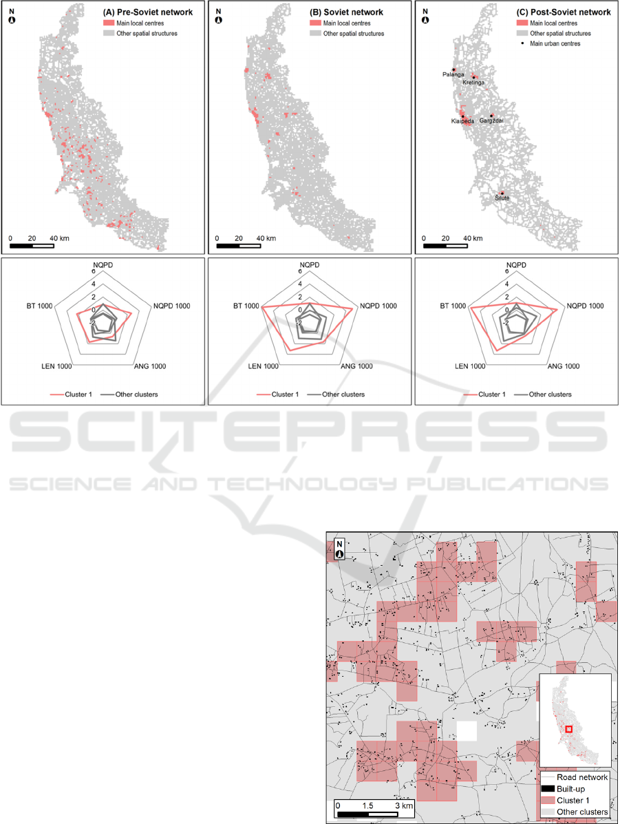
Figure 3: Spatial evolution of networks relating to local centres between the (a) pre-Soviet, (b) Soviet, and (c) post-Soviet
periods.
south, with noteworthy development of individual
and family farms (Figure 3a and Figure 4).
In the post-Soviet era, the primary local centres
correspond to the main urban hubs of the coastal
region, specifically Klaipėda, Palanga, Kretinga,
Gargždai, and Šilutė (Figure 3c).
This transformation can be attributed to the
agricultural and land planning policies implemented
by the Soviet Union, which resulted in the dissolution
of individual and family farms and their replacement
with collective farms, such as ‘sovkhoz’ and
‘kolkhozes’ in the early 1950s (Gadal, 2011; Köll,
2024). The structure of the pre-Soviet individual and
family farms is comparable to these main urban
centres in terms of accessibility, underscoring their
historical significance in the economic and territorial
development of the Klaipėda region. Accessibility
analysis supports this conclusion: the top 25% of
values for the pre-Soviet network exceed 1.30, while
the post-Soviet network shows values of 1.70,
indicating a more organic and interconnected network
prior to Soviet policies of land collectivisation.
The reconfiguration of the network illustrates the
process of metropolisation taking place in the Baltic
countries (Ubarevičienė, 2018). This process
commenced during the Soviet period when territorial
planning adhered to a ‘hierarchical centre-periphery’
model (Vanagas et al., 2002). Klaipėda was
designated as a regional centre, intended to be linked
Figure 4: Network associated with local centres: the case of
individual/family farms during the pre-Soviet period.
GISTAM 2025 - 11th International Conference on Geographical Information Systems Theory, Applications and Management
66
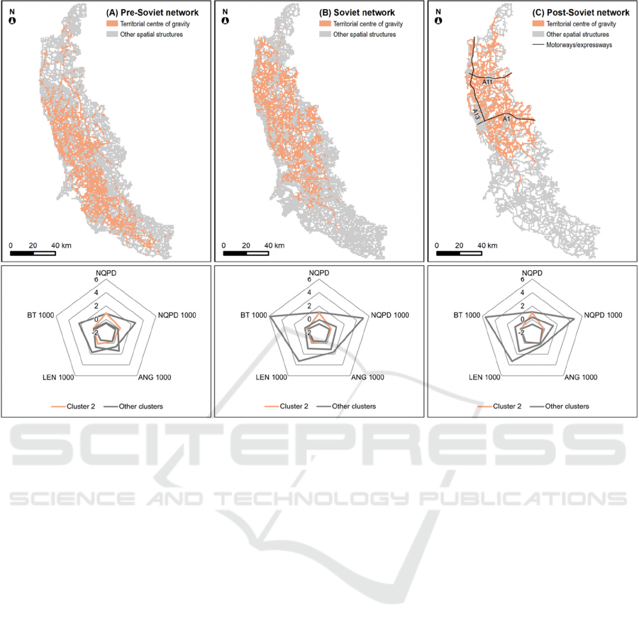
Figure 5: Spatial evolution of networks relating to territorial centre of gravity between the (a) pre-Soviet, (b) Soviet, and (c)
post-Soviet periods.
to secondary regional centres through a network of
smaller cities like Palanga or Kretinga. In the post-
Soviet period, this process accelerated as the Soviet
territorial framework persisted, leading to heightened
urbanisation of the main urban centres. The findings
from the Betweenness index at the local level (section
4) are particularly illuminating, revealing a more
pronounced hierarchy of networks emerging from the
Soviet era onwards.
5.2 Territorial Centre of Gravity
The second spatial structure is associated with grid
tiles that exhibit high averages for the foreground
network index (Figure 5).
These identified grid tiles correspond to the
territorial centre of gravity, highlighting the most
efficient networks at the regional level in terms of
accessibility — networks that bolster regional
economic development. The shift of the territorial
centre of gravity from the south to the centre of the
region is the main change observed between the pre-
Soviet and post-Soviet periods (Figure 5).
Two complementary interpretations can be made
regarding this spatial evolution. The first pertains to
geopolitical changes within the region: during the
pre-Soviet period, the southern part of the coastal
region was under Prussian control and was an integral
part of East Prussia, with Königsberg (now
Kaliningrad) as its capital (Figure 9a). The
establishment of the Lithuanian state after World War
I led to a severance of the historical connections with
present-day Kaliningrad oblast. The designation of
Klaipėda as the administrative centre of the coastal
region (currently known as ‘Klaipėda apskritis’)
marks a significant shift in the network’s centre of
gravity toward the heart of this coastal region.
A second interpretation pertains to the economic
transformations that have occurred since the 20
th
century. During the pre-Soviet period, the region’s
economy relied on agriculture, with the most
developed networks corresponding to areas of intense
agricultural activity. The presence of individual and
family farms as local centres (section 5.1) supports
this notion. However, in the post-Soviet era, the
economy underwent a substantial transformation,
realigning itself around industrial and service sectors.
Consequently, the network’s centre of gravity is now
found in the primary industrial and tourist hotspots,
Modelling the Road Network as an Expression of Historical Spatial System Change in the Klaipeda Region (Lithuania)
67
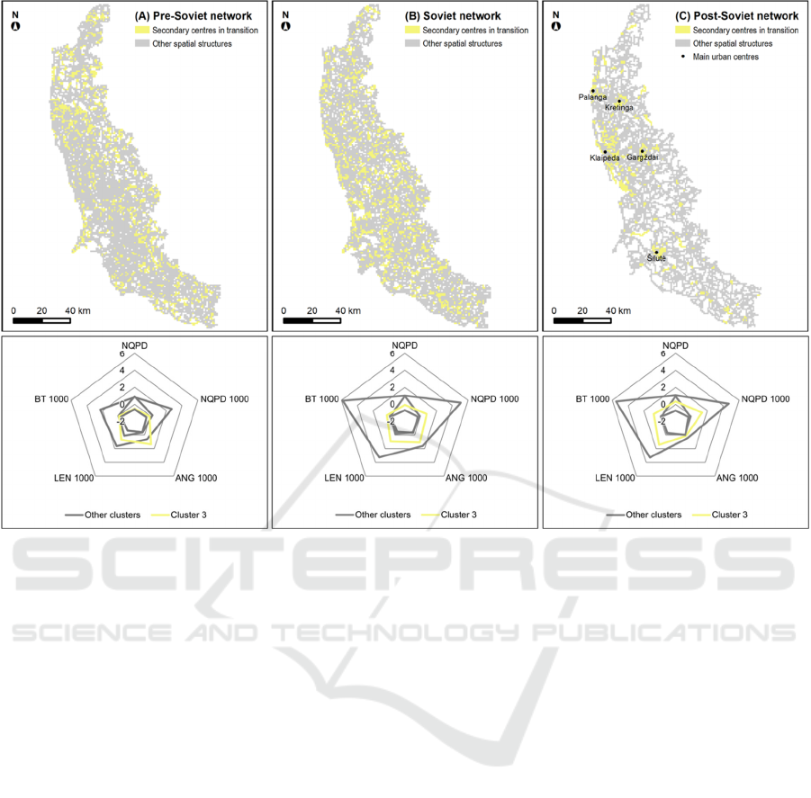
Figure 6: Spatial evolution of networks relating to secondary centres in transition between the (a) pre-Soviet, (b) Soviet, and
(c) post-Soviet periods.
specifically the port of Klaipėda and the seaside
resorts of Palanga and Šventoji.
It is also noteworthy that these economic shifts are
intricately linked to the development of specific
transport infrastructures. In this respect, motorways
have played a crucial role in defining the network’s
centre of gravity in the coastal region (Figure 5c). The
first key route (east-west) is the ‘A1’ motorway,
which connects Klaipėda (on the Baltic Sea) with
Odesa (on the Black Sea) and Moscow. According to
the Soviet military maps from 1985, the motorway’s
construction was incomplete, aside from the sections
near Klaipėda. The second major route (south-north)
is the ‘A13’ motorway, which links Klaipėda and the
northern part of the coastal region with Latvia. The
third route (east-west) establishes a connection
between Palanga and the regional centre of Šiauliai
(outside the study area) via the ‘A11’ motorway,
passing through Kretinga. The development of these
routes has further influenced the local hierarchy of the
network, as evidenced by the Betweenness index
during both the Soviet and post-Soviet periods
(section 4).
The trends for these first two spatial structures
mirror those identified by Strano et al. (2012) in the
suburbs of Milan, showcasing a transformation of the
territory from rural areas to urban-industrial zones,
and eventually to metropolitan regions.
5.3 Secondary Centres in Transition
The third spatial structure is associated with grid tiles
that exhibit, on average, low to medium background
network indexes when compared to other spatial
structures (Figure 6). Across all periods analysed, the
average standardised indexes for the spatial structure
of the main local centres consistently exceed those of
this structure: 4.15 compared to 0.66 for NQPD, 2.72
compared to 1.02 for the Length, and 4.57 compared
to 0.32 for Betweenness.
This spatial structure denotes networks that are in
a ‘transition phase’ towards main local centres
(section 5.1) or peripheral areas (section 5.4). For
instance, during the post-Soviet period, this cluster
was situated in peri-urban zones surrounding key
urban centres like Klaipėda or Kretinga (Figure 6c),
which can be classified as secondary centres.
GISTAM 2025 - 11th International Conference on Geographical Information Systems Theory, Applications and Management
68
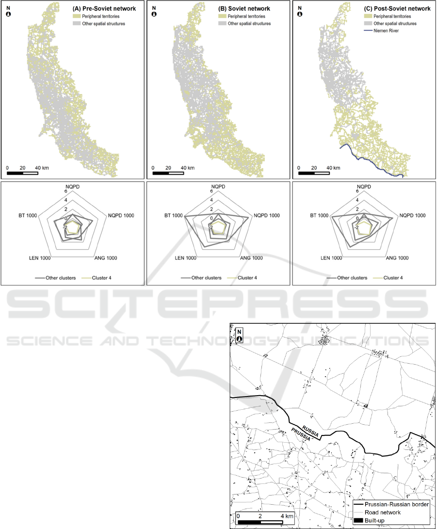
Figure 7: Spatial evolution of networks related to peripheral territories between the (a) pre-Soviet, (b) Soviet, and (c) post-
Soviet periods.
5.4 Peripheral Territories
The fourth spatial structure is characterised by grid
tiles exhibiting low average indexes, irrespective of
the type of network (Figure 7).
The grid tiles identified within this spatial
structure are linked to the peripheral networks at the
regional scale. For instance, during the post-Soviet
period (Figure 7c), these peripheral networks were
found in the agricultural and semi-natural areas of the
Niemen delta, as well as the riparian zones along the
Niemen River, delineating the southern border with
Russia. In comparison to the pre-Soviet era, contem-
porary agricultural practices are more modern but less
intensive, reflecting a trend of agricultural decline
(Lekavičiūtė and Gadal, 2009; Spiriajevas, 2014).
Moreover, the motorway infrastructure, which
facilitates more efficient access to the network, is
confined to the northern part of the coastal region.
This overall marginalisation of the southern region
may partially account for the observed decline in the
foreground network index.
During the pre-Soviet period (Figures 7a and 9a),
it is noteworthy that the peripheral networks
corresponded to territories under Russian control.
Figure 8: Patterns of spatial organisation between Prussia
and Russia in pre-Soviet Lithuania.
Two distinct patterns of spatial organisation
appear to emerge between the two countries (Figure
8): one explanation for this could relate to the
Modelling the Road Network as an Expression of Historical Spatial System Change in the Klaipeda Region (Lithuania)
69
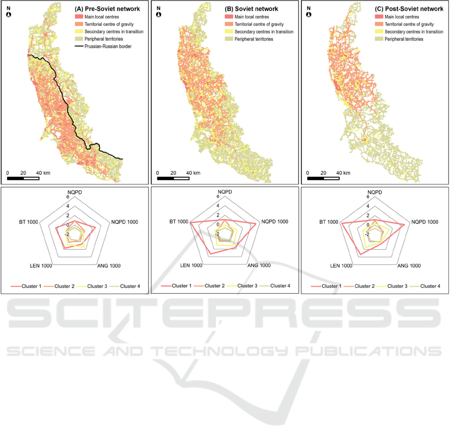
Figure 9: Spatiotemporal modelling of spatial structures relating to road network in the Klaipeda region between (a) the pre-
Soviet period, (b) the Soviet period, and (c) the post-Soviet period.
differing timelines of agrarian reform. In Prussia, the
reform aimed at developing the familial farming
model was implemented earlier (in the early 19
th
century) compared to Russia, where the reform was
introduced later (in the late 19
th
century), and the
traditional street village model was retained (Jespen
et al., 2015).
6 CONCLUSIONS AND
PERSPECTIVES
This research analyses the evolution of spatial
structures and territorial organisation in the Klaipėda
region since the 20
th
century, utilising the Generic
City concept to model road networks.
By distinguishing between foreground and
background networks with indexes tailored for
regional analysis, this study measures the relationship
between the spatial configuration of space and its
associated functions, thereby illustrating various
processes at play within the Klaipėda territory.
The significant territorial restructuring observed
during the pre-Soviet and post-Soviet periods is
particularly evident in the integration of local urban
centres along the coastal region, driven by the
dynamics of metropolisation. This metropolisation
was accompanied by a shift in the region’s economic
function from agriculture to industry and services.
The development of motorway infrastructure further
bolstered this territorial growth, enhancing regional
accessibility while marginalising agricultural areas
that once formed the core of the territory.
Additionally, the collectivisation reforms and
geopolitical shifts following the disintegration of the
former province of East Prussia contributed to this
marginalisation.
In this study, the Generic City indexes —
modified and adapted for territorial analysis —
proved effective in highlighting the interconnected
political, economic, social, and cultural factors that
influence the spatial and territorial organisation of the
Klaipėda region.
The reliability of the modelling was partly
validated by the alignment of results with existing
scientific literature on this region. Incorporating
supplementary data, such as built-up areas, land use,
and land cover, could further strengthen the model if
similar trends are identified. However, the indexes
associated with the Generic City concept, modified
GISTAM 2025 - 11th International Conference on Geographical Information Systems Theory, Applications and Management
70

for regional analysis, can only be generalised through
examination in other territorial contexts exhibiting
comparable dynamics. In this respect, the Baltic Sea
region presents intriguing opportunities, particularly
considering the rapid, intense and complex impacts of
political, economic, social, and cultural changes on
spatial and territorial organisation.
In this regard, the historical application of
generative models remains constrained when they are
trained on overly general databases. The approach
developed in this research, which utilises
mathematical graph models, has been tailored from
generic indexes to conduct a thorough analysis of
existing structures at a territorial scale. This method
considers the complexities of the Baltic region,
characterised by the interplay of various cultural
influences, including Prussian, Russian, Soviet, and
post-Soviet elements.
From a methodological standpoint, this research
enables a connection between historical spatial
structures and specific territorial functions, such as
agricultural activities. Furthermore, spatiotemporal
modelling of road network structures could serve to
enhance missing or incomplete historical data in
retrospective modelling studies.
ACKNOWLEDGEMENTS
This Research is supported by the Science Council of
Lithuania's “Next Generation of Multi-Objective
Satellite Image Recognition Algorithms for Climate
Monitoring” program (LMT NEUTRINO) and the
CNES TOSCA THRISNA ISEULT.
REFERENCES
Al Sayed, K., Turner, A., Hanna, S. (2009). Cities as
emergent models: the morphological logic of
Manhattan and Barcelona. In Proceedings of the 7
th
International Space Syntax Symposium. Royal Institute
of Technology (KTH), Stockholm.
Allain, R. (2004). Morphologie urbaine. Géographie,
aménagement et architecture de la ville. Armand Colin.
Abida, H. (2018). Syntaxe Spatiale comme un outil
d’analyse de l’espace architectural. International
Journal of Innovative Technical and Applied Sciences,
2(1), 22-30.
Archaeomedes. (1998). Des oppida aux métropoles.
Economica Anthropos.
Badariotti, D. (2005). Des fractales pour l’urbanisme ?
Quelques pistes de réflecion à partir de l’exemple de
Strasbourg-Kehl. Cahiers de géographie du Québec,
49(137), 133-156.
Barrington-Leigh, C., Millard-Ball, A. (2017). The world’s
user-generated road map is more than 80% complete.
PloS one, 12(8).
Bučas, J. (2001). Kraštotvarkos pagrindai. Technologija.
Cirtautas, M. (2015). Changing periphery of the Baltic
cities: Lithuanian case. Journal of Architecture and
Urbanism, 39(1), 56-69.
Cooper ; C., Chiaradia, A. (2020). sDNA: 3-D spatial
network analysis for GIS, CAS, Command Line &
Python. Software X 12, 100525.
Cooper, C. (2024). Spatial Design Network Analysis
(sDNA) Version 4.1 Manual. Cardiff University.
Retrieved from http://sdna.cardiff.ac.uk/sdna/software/
documentation
Dringelis, L., Ramanauskas, E., Povilaitienė, I.,
Mačiukėnaitė, J. (2015). Exploration and respectation
of the spatial structure of cities, towns, townships and
villages as a significant formant of their identity.
Journal of Architecture and Urbanism, 39(1), 79-100.
Elissalde, B. (2004). Spatial structure. Hypergeo. Retrieved
from https://hypergeo.eu/spatial-structure/?lang=en
Gadal, S. (2011). Métropolisations, territoires émergents et
systèmes géographiques d’information et de
modélisation territoriale [Habilitation à Diriger des
Recherches]. Université Paris Diderot Paris 7.
Georges, P., Verger, F. (2013). Dictionnaire de la
géographie, 4
e
édition. Presses universitaires de France.
Gloaguen, T., Zaleckis, K., Gadal, S. (2023). Development
of new indexes of the ‘Generic City’ in the Baltic
coastal city network. In XXIX International Seminar on
Urban Form ISUF 2022: Urban Redevelopment and
Revitalisation. A Multidisciplinary Perspective. Łódź
University of Technology Press, 365-378.
Hillier, B. (2007). Space is the machine: a configurational
theory of architecture. Space Syntax.
Hillier, B. (2010). The Need for A Spatial Ontology for
Societies (The Space Syntax Workshop). The European
Archaeological Association Conference, The Hague,
Amsterdam.
Idzelis, A. (1984). Industrialisation and population change
in the Baltic republics. Lituanus, 30(2).
Jespen, M.R., Kuemmerke, T., Müller, D., Erb, K.,
Verburg, P.H., Haberl, H., …, Reenberg, A. (2015).
Transitions in European land-management regimes
between 1800 and 2010. Land use policy, 49, 53-64.
Köll, A. M. (2024). Reinterpretation of economic history in
the Baltic countries, 30 years after independence.
Scandinavian Economic History Review, 1-10.
Laouar, D., Mazouz, S. (2017). La carte axiale, un outil
d’analyse de l’accessibilité spatiale : cas de la ville
d’Annaba. Synthese : Revue des Sciences et de la
Technologie, 35, 111-123.
Lekavičiūte, J., Gadal, S. (2009). Forest Cover Changes
during 1975-2005 in the Lithuanian Coastal Region.
Rural Development 2008, 241.
Peponis, J., Bafna, S., Zhang, Z. (2008). The connectivity
of streets: reach and directional distance. Environment
and Planning B: Planning and Design, 35(5), 881-901.
Piškinaitė, E., Veteikis, D. (2023). The Results of
Digitizing Historical Maps: Comparison of Lithuanian
Modelling the Road Network as an Expression of Historical Spatial System Change in the Klaipeda Region (Lithuania)
71

Land-Use Structure in the 19
th
and 21
st
Centuries. Land,
12(5), 946.
Plakans, A. (2011). A concise history of the Baltic states.
Cambridge University Press.
Ragauskaitė, A. (2019). Ethnocultural regionalization of
Lithuania or all the truth about our regions. Acta
Museologica Lithuanica, 4, 162-168.
Spiriajevas, E. (2014). Hindrances and suggestions for
sustainable development of Lithuanian Coastal Strip
(Zone). Regional Formation and Development Studies.
6(1), 125-136.
Strano, E., Nicosia, V., Latora, V., Porta, S., Barthélémy,
M. (2012). Elementary processes governing the
evolution of road networks. Scientific reports, 2(1),
296.
Ubarevičienė, R. (2018). City systems in the Baltic states:
the Soviet legacy and current paths of change. Europa
Regional, 25(2), 15-29.
Ubarevičienė, R., Van Ham, M. (2017). Population decline
in Lithuania: who lives in declining regions, and who
leaves? Regional Studies, Regional Science, 4(1), 57-
79.
Vanagas, J., Krišjane, Z., Noorkoiv, R., Staniunas, E.
(2002). Planning urban systems in Soviet times and the
era of transition: the case of Estonia, Latvia and
Lituania. Geographia Polonica 75(2), 75-100.
Vaitkus, G., Vaitkuvienė, D. (2005). Land cover changes in
the Lithuanian coastal zone during 1975-2000. Acta
Zoologica Lituanica 15(2), 183-187.
Veteikis, D., Šabanovas, S. Jankauskaitė, M. (2011).
Landscape structure changes on the coastal plain of
Lithuania during 1998-2009. Baltica, 24(2), 107-116.
Voiron-Canicio, C. (1995). Analyse spatiale et analyse
d’images par la morphologie mathématique. GIP
Reclus.
GISTAM 2025 - 11th International Conference on Geographical Information Systems Theory, Applications and Management
72
