
Data-Driven Analysis of Bicycle Lane Safety in Mexican Cities:
Towards a Real-Time Route Recommendation System for Cyclists
Carlos Alberto Domínguez-Báez
1,2 a
, Ricardo Mendoza-González
1b
and Huizilopoztli Luna-García
2c
1
Tecnológico Nacional de México / IT Aguascalientes, Av. Adolfo López Mateos, 1801 Ote., Aguascalientes, Mexico
2
Universidad Autónoma de Zacatecas, Ramón López Velarde 801, Zacatecas, Mexico
Keywords: Data-Driven Analysis, Safe Bicycle Lanes, Urban Eco-Mobility.
Abstract: This study initiated a project to identify urban cycling routes with a focus on cyclist safety in Mexican cities.
A Data-Driven Analysis approach was implemented to map the riskiest and safest cycling routes by analysing
traffic accident data from national, state, and local datasets. The accident hotspots were visually integrated
into the urban map of Guadalajara city (Jalisco, Mexico), to identify high-risk zones for cyclists. The
integration of diverse data sources and geospatial analysis allowed for an accurate characterization of accident
patterns, providing a clear identification of critical areas. Key results from this initial stage of the project
included an accurate risk-zones identification, a replicable methodology for data integration, and a first
approach to developing algorithms for cyclist accident analysis. These preliminary findings hold promise for
enhancing urban cycling safety and supporting urban eco-mobility strategies in Mexican cities. Additionally,
the results served as a foundation for future exploration of machine learning techniques to refine data
processing and develop a real-time safe bicycle lane recommender prototype aimed at guiding cyclists toward
safer alternatives.
1 INTRODUCTION
Effective transportation system planning must
address not only the mobility needs of individuals but
also ensure safety and sustainability, promoting eco-
friendly strategies. According to the World
Commission on Environment and Development,
sustainable development involves meeting the needs
of the present without compromising the ability of
future generations to meet their own needs. In this
context, transportation systems play a crucial role in
sustainable development by facilitating access to
economic and social opportunities, which is essential
for balanced growth across economic, social, and
environmental spheres (Visser, 2017).
One of the major challenges in creating
sustainable transportation networks is overcoming
natural barriers and reducing environmental impact
(Mahfouz, et al., 2023). Transportation infrastructure
must evolve to ensure sustainable mobility, not just
a
https://orcid.org/0000-0001-8820-5518
b
https://orcid.org/0000-0002-8934-8067
c
https://orcid.org/0000-0001-5714-7482
through the construction of adequate road networks,
but also by integrating solutions that minimize
environmental harm (Bahmankhah & Coelho, 2017).
Urban transport sustainability is closely linked to the
implementation of innovative systems that foster
public trust and promote less polluting transport
modes, such as cycling (Bahmankhah & Coelho,
2017; Černá, et al., 2014).
Cycling has emerged as a prominent option within
urban eco-mobility strategies (Ogryzek, 2020).
Although in many developing countries, bicycles are
primarily used for recreational purposes, their
potential as a daily transportation mode is significant
(Heesch & Sahlqvist, 2013). Promoting cycling can
drastically reduce CO2 emissions, alleviate traffic
congestion, and improve air quality (Nasir, 2024;
Batool, et al. 2024). Bicycles, as an eco-friendly
mode of transport, play a key role in reducing vehicle
emissions, minimizing congestion, and lowering
transportation costs, in addition to benefiting the
Domínguez-Báez, C. A., Mendoza-González, R. and Luna-García, H.
Data-Driven Analysis of Bicycle Lane Safety in Mexican Cities: Towards a Real-Time Route Recommendation System for Cyclists.
DOI: 10.5220/0013365100003941
Paper published under CC license (CC BY-NC-ND 4.0)
In Proceedings of the 11th International Conference on Vehicle Technology and Intelligent Transport Systems (VEHITS 2025), pages 543-548
ISBN: 978-989-758-745-0; ISSN: 2184-495X
Proceedings Copyright © 2025 by SCITEPRESS – Science and Technology Publications, Lda.
543

physical and mental health of users (Gulati, 2024).
Numerous studies have shown that policies
promoting cycling significantly improve urban
quality of life. As a result, many governments
worldwide are implementing initiatives to encourage
its use (Kosmidis & Müller-Eie, 2024).
Despite the numerous benefits of cycling, its
integration into cities must account for the safety of
cyclists and pedestrians, which is compromised in
cities where cycling infrastructure is inadequate or
poorly located (Liu, et al., 2024). The development of
safe and dedicated cycling infrastructure, such as
exclusive bike lanes, is critical to encouraging cycling
(Khademi, et al., 2024). While some studies suggest
that increased infrastructure availability can boost
cycling trips, it is also emphasized that simply
improving infrastructure is not enough; these spaces
must be safe, particularly for cyclists and pedestrians
and other aspects need to be addressed too, such as
perceptions of insecurity, and cultural barriers (Al-
Ansari & Al-Khafaji, 2024; Khademi, et al., 2024).
This necessitates planning that includes physical
separation from motorized traffic, speed reductions,
and educational campaigns that promote road safety
from an early age (Toski, et al., 2024).
Moreover, social attitudes and norms play a
pivotal role in the adoption of sustainable transport
modes (Kočková, et al., 2024). People living in bike-
friendly environments, such as cities with adequate
infrastructure, are more likely to use bicycles
frequently than those in areas with fewer facilities
(Khademi, et al., 2024; Useche, et al. 2024).
Promoting favourable attitudes toward cycling
through public policies and community support is
essential to shifting transportation habits (Khademi,
et al., 2024; Kočková, et al., 2024).
In several countries such as Mexico, strategies
are being successfully implemented in favour of the
use of bicycles as a means of transportation, such as:
EcoBici in Mexico City (Peralta, 2016), and MiBici
(https://www.mibici.net/), in Guadalajara; however,
these alternatives tend to be visualized only in a few
large cities. In most of the territory the needs of
infrastructure, social awareness, and safety are still
very evident (Lagunas-Millan, 2018). Investments in
cycling infrastructure often fail to meet the needs of
regular cyclists, who are mostly from low-income
backgrounds (Lagunas-Millan, 2018; Peralta, 2016).
Additionally, the lack of connectivity and poorly
planned cycling routes expose cyclists to safety risks,
as they are forced to share roads with motorized
traffic without proper lanes (Lagunas-Millan, 2018;
Peralta, 2016). This highlights the need for planning
and forecasting tools that integrate built environment
characteristics to prioritize infrastructure investments
in high-need areas (Etminani-Ghasrodashti, 2018).
In this context, optimizing cycling routes and
infrastructure is crucial to maximizing the benefits of
cycling mobility (Komarica, et al. 2024). Advanced
technologies such as Artificial Intelligence (AI) and
Machine Learning (ML) enable the analysis of data
on road safety, traffic flow, and emissions to design
more efficient solutions (Komarica, et al. 2024;
Younus, et al. 2025). AI can help identify optimal
routes for cyclists by considering variables such as
safety, travel time, emissions, and user preferences
(Younus, et al. 2025). Integrating multi-objective
optimization enables balancing traffic performance,
safety, and emissions, thereby promoting the use of
more sustainable transport modes like cycling
(Avina-Bravo, et al. 2022; Koska et al. 2021).
In summary, advancing toward more eco-friendly
and safe urban mobility requires integrating
innovative technologies that optimize infrastructure
and urban planning. These solutions must ensure the
safety of cyclists and pedestrians, maximize
transportation system efficiency, and reduce harmful
emissions. Cycling, as an eco-friendly transport
mode, plays a vital role in this process, and its
effective integration into cities depends on policies
and technologies that consider local characteristics
and user needs.
To address this gap, we have initiated a project
aimed at identifying urban cycling routes with an
emphasis on cyclist safety in Mexican cities. From an
initial literature review (see Section 2 for
methodology details), we identified four key papers
that are directly relevant to this project. A summary
of these related works is provided below, ordered by
relevance, to establish the context and highlight their
contribution to the current research.
1. Seoudi et al. (2023) proposed a multi-criteria
route planning strategy that optimizes the
comfort, health, and safety of cyclists. Their
system operates independently of specific bike
lane information or traffic regulations,
incorporating real-time weather data to
improve the optimization of urban cycling
routes.
2. Ferreira and Costa (2024) developed an
innovative low-cost integrated system to
improve cycling safety in urban environments.
The system assesses proximity to emergency
services and uses GPS coordinates to determine
dynamic levels of risk for cyclists, generating
real-time alerts when crossing high-risk areas.
3. The research of (Pindarwati & Wijayanto,
2019) describes an integrated web-based
VEHITS 2025 - 11th International Conference on Vehicle Technology and Intelligent Transport Systems
544

system for personalized navigation that uses
crime hotspot data from local agencies, social
media, and user reports. The system offers
rerouting options and a crime risks zones map,
aiming to recommend safer routes to users.
4. Chavez et al. (2019) presented the Safe
Commuting System (SCS), a solution designed
to improve urban commuting safety through
crowdsourced mobile device data. The system
implements real-time user alerts for safety
incidents and provides alternative routing
options by categorizing data into three main
domains: criminal activity, perceived danger,
and suspicious behaviour.
These studies serve as a foundational basis for the
proposed approach, offering valuable insights and
guiding the development of insights to evolve the
proposal. In this case, for this initial stage of the
project, we mapped the riskiest and safest cycling
routes by analysing traffic accident databases
available at national, state, and city levels. This
analysis was then visually represented by overlaying
accident hotspots onto the urban map of Guadalajara,
Jalisco, Mexico. The results from this stage are
expected to serve as the foundation for developing a
real-time urban cycling route recommender system.
This system will guide cyclists by suggesting safer
alternative routes and providing safety-related
information, thus contributing to improved urban
mobility and eco-friendly transportation solutions.
The rest of the article is organized as follows:
Section 2 describes the methodology employed to
carry out this stage of the project. Section 3 details the
development of the first stage and presents the results
obtained so far. Finally, Section 4 offers the
conclusions of this stage and outlines potential
directions for future work.
2 METHODOLOGY
A literature review was conducted using the Semantic
Scholar tool (https://www.semanticscholar.org). This
review led to the identification of a final pool of 22
relevant sources (out of an initial pool of 669),
comprising 12 peer-reviewed research articles, eight
conference papers from international forums, one
international project report, and one article from a
blog. The selected sources were filtered based on their
relevance to the topic, considering citation counts and
recency, with a focus on publications from 2017 to
2024.
The analysis of the selected literature provided
insights into the general strategy for constructing the
accident analysis database (BD) and highlighted
various technological strategies that could be
implemented in subsequent project phases.
As part of the methodology, an initial database
was created using official traffic accident and
vehicular flow records from the following sources:
1. National Institute of Statistics and Geography
(INEGI, Mexico): The INEGI database serves
as a primary source of national traffic accident
data in Mexico. This dataset includes 43
distinct fields, including: a) Geospatial
information: accident latitude and longitude;
temporal data: year, month, day, hour, and
minute; b) Accident characteristics: type,
cause, and road conditions; c) Vehicle
information: types (including bicycles) and
numbers of vehicles involved; d) Victim data:
number of injuries and fatalities by user type;
e) Contextual information: type of roadway,
urban/suburban conditions. The detailed
structure of the database allowed for an in-
depth analysis of the specific circumstances
surrounding each incident, facilitating the
identification of contributing factors and
patterns.
2. Institute of Statistical and Geographical
Information of Jalisco (IIEGJ, Mexico): This
regional database complements the national
dataset (BD1) with local context-specific
details. It includes 20 fields, focusing on: a)
Unique incident identifiers; b) Detailed
temporal data; c) Precise location with cross-
referenced street information; d) Detailed
accident typology, such as cyclist involvement;
e) Demographic characteristics of the involved
individuals; f) Specific consequences of the
incidents. This dataset is particularly valuable
due to its regional focus, providing contextual
information specific to the metropolitan area of
Guadalajara (Jalisco, Mexico).
3. “GDL en Bici Program”, Jalisco State
Government (Mexico): This database is part of
a comprehensive traffic infrastructure dataset,
containing geospatial data critical to the
existing network of bicycle lanes. It operates
within a GeoJSON framework, including a)
Precise geometry of bicycle lanes; b)
Infrastructure attributes such as the type of
segregation; c) Temporal information on
construction and modifications; d) Design
technical characteristics. The inclusion of this
dataset was particularly important, given its
Data-Driven Analysis of Bicycle Lane Safety in Mexican Cities: Towards a Real-Time Route Recommendation System for Cyclists
545

focus on bicycle infrastructure, offering vital
information to assess areas with higher cyclist
risk in urban settings.
These databases were selected because of their
thoroughness and the fact that they are publicly
accessible within Mexico. They provided detailed
information on traffic accidents, with a particular
emphasis on cyclist involvement, which is critical for
evaluating the safety of cycling routes in urban
environments using both dedicated bike lanes and
conventional traffic lanes.
The analysis of these datasets allowed for the
identification of patterns that will support the
development of strategies aimed at improving urban
mobility and reducing accident rates related to
cycling. For this preliminary analysis, the data were
processed using Python to detect patterns and suggest
specific locations on the map interpreted as high-risk
and low-risk accident zones. Finally, the results were
visualized using Geographic Information System
(GIS) software, including QGIS (freeware,
https://www.qgis.org) and OpenStreetMap (freeware,
https://www.openstreetmap.org).
3 DEVELOPMENT AND FIRST
RESULTS
This section summarizes the development actions
corresponding to the first stage of the project. These
actions include the integration, processing, and
visualization of the three selected databases; the
processing and visualization of hot spots; and the risk
weighting of cycling routes.
3.1 Integration, Processing, and
Visualization of the Selected
Databases
The integration process began with an extensive pre-
processing stage, involving the following actions:
1. Format Normalization: it consisted in
standardization of geographic coordinates to a
unified system (EPSG:32613), the
homogenization of temporal formats, and
unification of accident and vehicle type
nomenclatures
2. Data Cleaning: This step was characterized by
the identification and correction of outliers, the
validation of geographic coordinates, and the
consistency checks for key fields.
Subsequently, the databases were unified through
a Python-based algorithm, implementing the
following steps: a) Identification of common fields;
b) Standardization of field names; c) Duplicate
identification based on spatial and temporal
proximity.
Duplicate records were identified based on
spatiotemporal criteria, considering records as
duplicates if they met the following conditions: a)
Spatial distance of less than 3 meters; b) Temporal
difference of less than 1 hour; c) Matching accident
type and involved vehicles.
The integration process resulted in a unified
database containing 829 filtered bicycle accident
records, with a temporal coverage from January 2015
to June 2024. The results of this initial data
processing and representation are shown in Figure 1.
Figure 1: The 829 filtered bicycle accident records.
3.2 Processing and Visualization of Hot
Spots Processing
The spatial analysis of hotspots was executed using
QGIS 3.34, implementing a multiscale method for the
generation of the heat density map. The configuration
parameters were set according to specific technical
criteria:
Radius of influence: 20 meters (determined by
standard safety braking distance).
Maximum value: Automatic configuration
based on data distribution.
Chromatic gradient: Turbo spectrum.
Rendering resolution: Medium.
The application of this analysis allowed the
identification and categorization of critical zones,
resulting in three high-risk and seven moderate-risk
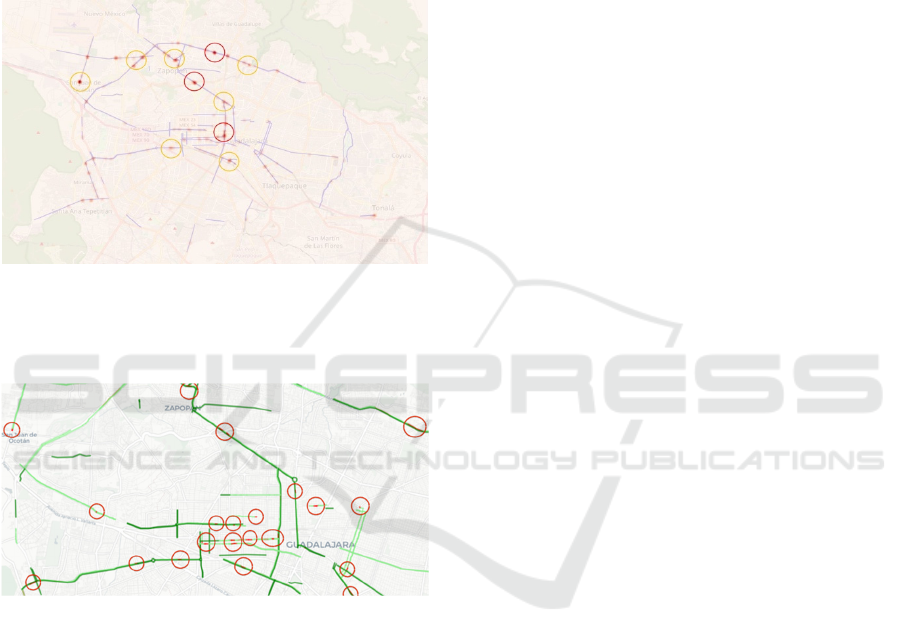
areas. Figure 2 presents the spatial visualization of
these critical points resulting from the analysis.
VEHITS 2025 - 11th International Conference on Vehicle Technology and Intelligent Transport Systems
546
3.3 Risk Weighting of Cycling Routes
A Python algorithm was developed to assign risk
weights to cycling route segments, considering the
following criteria:
Spatial proximity to the cycling route segment.
Temporal frequency of incidents.
The initial results of this processing are presented in
Figure 3.
Figure 2: Map representation of the three high-risk areas
and seven moderate-risk areas (Note: Hotspots were
highlighted manually in this figure to facilitate their
identification within the article).
Figure 3: Map representation of the weighted risk bicycle
routes (Note: Weighted lanes were highlighted manually in
this figure to facilitate their identification within the
article).
4 CONCLUSIONS AND FUTURE
WORK
Obtained results demonstrate the effectiveness of the
proposed methodology for identifying high-risk
zones in bicycle lanes. The integration of multiple
data sources allowed for a more precise
characterization of accident patterns, while the
geospatial analysis facilitated the objective
identification of critical areas. This Data-Driven
Analysis strategy implemented this strategy offers
several advantages compared to related works,
including a) More accuracy in identifying risk zones;
b) A replicable method for database integration in
different urban contexts; and c) A first approach to
the development and implementation of specific
algorithms for cyclist accident analysis was
summarized.
Thus, we infer that these preliminary results could
serve as a reliable foundation for the development of
intelligent technological solutions that provide real-
time safe route recommendations for cyclists. This
could significantly improve urban cycling safety in
Mexican cities and, in the medium term, contribute to
secure urban eco-mobility strategies with real-world
applicability across much of the national territory.
The next stages of the project involve exploring
machine learning techniques for data processing to
translate current analysis and results to real−time
route recommendations for cyclists.
It is important to note that the code generated as
part of the project is intended to be fully accessible;
however, at this initial stage, it is not yet available as
it is still undergoing testing and will be part of a
broader solution. Eventually, much more details on
the algorithms developed to assign risk weights to
cycling route segments, and the full code will be
made publicly available to promote collaboration and
knowledge generation.
REFERENCES
Al-Ansari, H. A., & Al-Khafaji, A. S. (2024). The Role of
Safety and Security in Achieving Urban Space Vitality.
International Journal of Safety & Security Engineering,
14(2).
Avina-Bravo, E. G., Cassirame, J., Escriba, C., Acco, P.,
Fourniols, J. Y., & Soto-Romero, G. (2022). Smart
electrically assisted bicycles as health monitoring
systems: a review. Sensors, 22(2), 468.
Bahmankhah, B., & Coelho, M. C. (2017). Multi-objective
optimization for short distance trips in an urban area:
choosing between motor vehicle or cycling mobility for
a safe, smooth and less polluted route. Transportation
Research Procedia, 27, 428-435.
Batool, T., Ross, V., Blerk, J. V., Neven, A., Dendale, P.,
Janssens, D., Wets, G., & Brijs, K. (2024). Promoting
sustainable transportation: a transtheoretical
examination of active transport modes. Sustainability,
16(2), 472.
Černá, A., Černý, J., Malucelli, F., Nonato, M., Polena, L.,
& Giovannini, A. (2014). Designing optimal routes for
cycle-tourists. Transportation Research Procedia, 3,
856-865.
Chavez, C.V., Ruiz, E., Rodríguez, A.G., Pena, I.R., Larios-
Rosillo, V.M., Villanueva-Rosales, N., Mondragon,
Data-Driven Analysis of Bicycle Lane Safety in Mexican Cities: Towards a Real-Time Route Recommendation System for Cyclists
547

O.A., & Cheu, R.L. (2019). Towards Improving Safety
in Urban Mobility Using Crowdsourcing Incident Data
Collection. 2019 IEEE International Smart Cities
Conference (ISC2), 626-631.
Etminani-Ghasrodashti, R., Paydar, M., & Ardeshiri, A.
(2018). Recreational cycling in a coastal city:
Investigating lifestyle, attitudes and built environment
in cycling behavior. Sustainable cities and Society, 39,
241-251.
Ferreira, J.M., & Costa, D.G. (2024). Enhancing Cycling
Safety in Smart Cities: A Data-Driven Embedded Risk
Alert System. Smart Cities, 1992-2014.
Gulati, V. (2024). Designing of an Eco-Friendly Foldable
Bicycle using basic concepts of engineering: E-
Compaq Bike. Journal of Engineering and Technology
Management, 74, 299-304.
Heesch, K. C., & Sahlqvist, S. (2013). Key influences on
motivations for utility cycling (cycling for transport to
and from places). Health promotion journal of
Australia, 24(3), 227-233.
Khademi, N., Naeinizadeh, M., Yeganeh, S. F.,
Behmanesh, A., Ekramifard, A., Chaiyasarn, K.,
Zheng, Z., Arbabpour Bidgoli, M., Azarmi, H.
Tarvirdizadeh, B., & Hadi, A. (2024). Building a less
intimidating cycling environment for women: A
structural equation modeling analysis based on a VR-
based laboratory experiment. Transportation research
part F: traffic psychology and behaviour, 100, 431-457.
Kočková, J., Dytrt, Z., Šimeček, M., & Adamovská, E.
(2024). Sharing the Roads: Exploring Drivers' Attitudes
and Cyclists' Perceived Legitimacy in the Czech
Republic. Available at SSRN 4681768.
Komarica, J., Glavić, D., & Kaplanović, S. (2024).
Predicting and Analyzing Electric Bicycle Adoption to
Enhance Urban Mobility in Belgrade Using ANN
Models. Applied Sciences, 14(19), 8965.
Koska, T., Schneider, P., Wetzchewald, A., & Ramesohl, S.
(2021) The Path to Sustainable Mobility Systems. A
study commissioned by Huawei Technologies
Germany GmbH. Available at URL: https://web.archi
ve.org/web/20220516082643id_/https://epub.wupperi
nst.org/frontdoor/deliver/index/docId/7939/file/7939_
Mobility_Systems.pdf
Kosmidis, I., & Müller-Eie, D. (2024). The synergy of
bicycles and public transport: a systematic literature
review. Transport reviews, 44(1), 34-68.
Lagunes-Millan, M (2018) La ciclovia como movilidad
sustentable; una propuesta mediante el análisis espacial
con geotecnologías, caso de estudio Zona Urbana de
Toluca, Master’s Thesis, Universidad Autónoma del
Estado de México. Available at URL:
http://ri.uaemex.mx/bitstream/handle/20.500.11799/99
443/MILLANLAGUNASMICHAEL-MC-MAEGI-
2018.pdf?sequence=1
Liu, Y., Maurer, M. L., Carstensen, T. A., Wagner, A. M.,
Skov-Petersen, H., & Olafsson, A. S. (2024). An
integrated approach for urban green travel
environments: Planning factors, benefits and barriers as
perceived by users and planners. Journal of Transport
Geography, 117, 103849.
Mahfouz, H., Lovelace, R., & Arcaute, E. (2023). A road
segment prioritization approach for cycling
infrastructure. Journal of transport geography, 113,
103715.
Nasir, R., Meng, H., Ahmad, S. R., Waseem, L. A., Naqvi,
S. A. A., Shahid, M., ... & Tariq, A. (2024). Towards
sustainable transportation: A case study analysis of
climate-responsive strategies in a developing nation.
Case Studies in Thermal Engineering, 55, 104117.
Ogryzek, M., Adamska-Kmieć, D., & Klimach, A. (2020).
Sustainable transport: An efficient transportation
network—Case study. Sustainability, 12(19), 8274.
Peralta, M. D. (2016) Enseñanzas del Sistema EcoBici para
la implementación de Sistemas de Bicicleta Pública en
México. Friedrich-Ebert-Stiftung in Mexico. Available
online at: URL https://library.fes.de/pdf-
files/bueros/mexiko/13013.pdf
Pindarwati, A., & Wijayanto, A.W. (2019). Personalized
safety route recommender application using integrated
urban crime hotspot data. Sixth Geoinformation
Science Symposium.
Seoudi, M.S., Mesabah, I., Sabry, M., & Soubra, H. (2023).
Virtual Bike Lanes for Smart, Safe, and Green
Navigation. 2023 IEEE Conference on Power
Electronics and Renewable Energy (CPERE), 1-6.
Toski, M., Cuevas, E., Avila, K., & Perez-Cisneros, M.
(2024). Enhancing Bicycle Trajectory Planning in
Urban Environments through Complex Network
Optimization. Journal of Urban Planning and
Development, 150(3), 04024023.
Useche, S. A., Alonso, F., Boyko, A., Buyvol, P.,
Makarova, I., Parsin, G., & Faus, M. (2024). Promoting
(Safe) Young-User Cycling in Russian Cities:
Relationships among Riders’ Features, Cycling
Behaviors and Safety-Related Incidents. Sustainability,
16(8), 3193.
Visser, W. (2017). Our common future (‘The brundtland
report’) world commission on environment and
development (1987). In The top 50 sustainability books
(pp. 52-55). Routledge.
Younus, M., Nurmandi, A., Mutiarin, D., Prianto, A. L.,
Karim, A. R. M., Manaf, H. A., Bambang, I., Sohsan,
I., Mappasere, F. A., & Gang, L. (2025). Exploring the
Digital Innovation in Smart City Through Smart Public
Transportation. In J. Mukthar K. P., V. Jain, S. Bing
Tsai, C. Huei Wu (Eds.) “Digital Innovations for
Renewable Energy and Conservation”, Chapter 7, 141-
166, IGI Global.
VEHITS 2025 - 11th International Conference on Vehicle Technology and Intelligent Transport Systems
548
