
Exploring Machine Learning and Remote Sensing Techniques for
Mapping Pinus Invasion Beyond Crop Areas
Andrey Naligatski Dias, Maria Eduarda Guedes Pinto Gianisella, Amanda Dos Santos Gonc¸alves,
Rodrigo Minetto and Mauren Louise Sguario Coelho de Andrade
Universidade Tecnol
´
ogica Federal do Paran
´
a, Ponta Grossa, Paran
´
a, Brazil
Keywords:
Machine Learning, Classification, Remote Sensing.
Abstract:
The spread of the exotic tree species from the Pinus spp. family has been increasing over the years in the
Ponta Grossa region and other areas of southern Brazil, making its monitoring necessary. This study proposes
to monitor this spread using deep neural networks trained on satellite images from the Campos Gerais region.
For this task, three deep neural network models focused on pixel-by-pixel classification were employed: U-
Net, SegNet, and FCN (Fully Convolutional Network). These models were trained on a dataset containing
34 images with a resolution of 2048x2048 pixels, obtained from Google Earth satellites. All images were
downloaded using the QuickMapServices extension available in QGIS, and labeled using the same program.
Promising results suggest that the U-Net model outperformed the others, achieving 82.49% accuracy, 69.62%
Jaccard index, 41.19% recall, and 78.47% precision. The SegNet model showed good accuracy at 82.84%,
but underperformed on the Jaccard index at 45.93%, with 58.34% recall and 68.35% precision. Meanwhile,
the FCN model produced less reliable results among the three, with 79.37% accuracy, 29.17% Jaccard index,
34% recall, and 67.21% precision.
1 INTRODUCTION
Pinus spp. plantations in southern Brazil have intro-
duced an alternative to the deforestation of trees in na-
tive reserve areas. Despite the positive economic im-
pacts, the environmental impacts, on the other hand,
have proven to be concerning, as Pinus is an exotic
and highly invasive species (Instituto
´
Agua e Terra,
2024). The region surrounding the Vila Velha State
Park in Paran
´
a, for example, is surrounded by farms
with large cultivation areas for this species. As a re-
sult, the park, home to around 1376 species of an-
giosperms and 151 species of pteridophytes (Cervi
et al., 2007), has been suffering threats for over two
decades. This has compromised soil fertility and the
region’s biodiversity.
Monitoring the spread of Pinus within the park’s
boundaries is a challenging task, particularly due to
the lack of manpower, the park’s vast area, and the
presence of wild animals that threaten the safety of
the inspectors. Remote sensing via imagery emerges
as an efficient alternative, providing information on
the location of Pinus plantations and helping gov-
ernments and forest managers effectively manage fo-
rest resources, ecological protection, and timber eco-
nomic planning, as is already being implemented in
China (Li et al., 2020).
Remote sensing image acquisition methods are di-
vided into satellite-based methods (Brandt and Stolle,
2020) and those using remotely piloted aircraft sys-
tems (RPAs) (Nascente and Nunes, 2020). In the first
case, data is freely available from various space agen-
cies and provides images on a global scale (Brandt
and Stolle, 2020), while RPAs require specialized la-
bor for their use.
Monitoring the spread of Pinus spp. must also effi-
ciently identify the species on a large scale. Integra-
ting satellite imagery and machine learning has shown
promising results in detecting green areas, especially
in identifying tree species (Zhang et al., 2023b).
So, the hypotheses are: the deep neural networks
U-Net, FCN and SegNet are effective in the task
of classifying Pinus spp. plantations using RGB
satellite images, demonstrating distinct capabilities in
pixel-wise segmentation? Furthermore, these models
are expected to exhibit significantly different perfor-
mances when evaluated using classification metrics
such as precision, recall, accuracy and Jaccard coeffi-
cient.
The hypothesis also posits that the U-Net architec-
ture, due to its design optimized for image segmenta-
tion, will outperform the other architectures in identi-
fying areas with the presence of Pinus spp. This work
seeks to answer these hypotheses.
Dias, A. N., Gianisella, M. E. G. P., Gonçalves, A. S., Minetto, R. and Coelho de Andrade, M. L. S.
Exploring Machine Learning and Remote Sensing Techniques for Mapping Pinus Invasion Beyond Crop Areas.
DOI: 10.5220/0013383900003912
Paper published under CC license (CC BY-NC-ND 4.0)
In Proceedings of the 20th International Joint Conference on Computer Vision, Imaging and Computer Graphics Theory and Applications (VISIGRAPP 2025) - Volume 3: VISAPP, pages
873-879
ISBN: 978-989-758-728-3; ISSN: 2184-4321
Proceedings Copyright © 2025 by SCITEPRESS – Science and Technology Publications, Lda.
873

2 BACKGROUND AND RELATED
WORK
John Brandt (Brandt and Stolle, 2020) proposed
the detection of tree canopies outside forests using
medium-resolution satellite images. Beloiu et al. (Be-
loiu et al., 2023) proposed a study on the detection
of tree species in heterogeneous forests using RGB
satellite images trained on deep neural network mo-
dels. More recently, Qin et al. (Qian et al., 2023)
studied the detection of dominant tree species in ur-
ban areas using the Zhuhai-1 satellite. The work of
Ortega Adarme et al. (Aparecido de Almeida et al.,
2020) evaluates deep learning techniques for detec-
ting deforestation in the Amazon and Cerrado re-
gions of Brazil. Zhan et al. (Zhang et al., 2023b)
demonstrated the importance of combining satellite
sensor data and machine learning algorithms to map
the distribution of tree species in urban areas, par-
ticularly in the context of reforestation project ma-
nagement and pest infestations. Li et al. (Li et al.,
2019) conducted a study proposing a two-stage con-
volutional neural network (TS-CNN) for large-scale
detection of oil palm plants using high-resolution
satellite images in Malaysia, addressing a common
challenge in agriculture and environmental monito-
ring. Zheng et al. (Zheng et al., 2021) developed a
method for detecting coconut tree canopies to iden-
tify and count coconuts in the Tenarunga region, using
high-resolution satellite images acquired from Google
Earth. This method involves three main procedures:
feature extraction, a multi-level Region Proposal Net-
work (RPN), and a large-scale coconut tree detection
workflow. Usman et al. (Usman et al., 2023) assessed
the use of high-resolution images from WorldView-
2 (WV-2) for classifying tree species in the agro-
forestry landscape of the Kano Close Settlement Zone
(KCSZ) in northern Nigeria. Their method involved
geographic object-based image analysis (GEOBIA) to
extract individual tree canopies and remotely identify
nine dominant species.
This interest is related to the increase in satellite
images available at no cost, as well as the ease of im-
plementation. In addition to being a powerful tool
for environmental study and preservation, it directly
contributes to natural resource management and the
fight against environmental crimes. To optimize the
use of these images, neural network models have been
widely employed, being trained with satellite data for
efficient application in various fields, such as fire pre-
vention, deforestation, agricultural area mapping, and
soil health monitoring (Handan-Nader et al., 2021).
In this context, this work aims to apply deep learning
techniques to detect the proliferation of the Pinus spp.
tree in various areas of the Ponta Grossa region, where
the species has been hindering the growth of native
vegetation. For this purpose, images obtained from
Google Earth will be labeled to be inserted into three
neural network models: U-Net, SegNet, and FCN,
which will be evaluated based on the chosen metrics.
3 MATERIALS AND METHODS
This chapter will be divided into subsections that will
cover the tools used, the creation of the dataset, the
models employed for training, and the evaluation me-
trics.
3.1 Study Area Characteristics
The vegetation of Vila Velha State Park, composed
mainly of woody grassy savanna and mixed rainfo-
rest, makes up the Atlantic Forest Biome. With an
area of 3,122.11 ha, located in the municipality of
Ponta Grossa, state of Paran
´
a (25º 14’ 09” South lati-
tude, and 50º 00’ 17” West longitude).
3.2 Utilized Materials
The training of the algorithms was carried out in the
Google Colab PRO environment, which offers the fol-
lowing specifications:
• 53 GB of RAM;
• Nvidia L4 with 22 GB of VRAM;
• 235 GB of storage.
All stages, including training, validation, and tes-
ting, were performed using the Python programming
language, in conjunction with its machine learning
and deep learning libraries, Scikit-Learn, Keras, and
TensorFlow.
3.3 Database Creation
For the formation of the database used in the trai-
ning, validation, and testing stages, satellite images
of specific coordinates in the Ponta Grossa region,
containing the Pinus spp., were collected in the RGB
channels. These images were obtained through the
QuickMapServices plugin in the QGIS software, an
open-source tool widely used in cartography, which
offers several options for labeling and image segmen-
tation (QGIS, ). The satellite images were down-
loaded from Google Earth satellites, including Land-
sat data, using the QuickMapServices plugin. They
VISAPP 2025 - 20th International Conference on Computer Vision Theory and Applications
874
were selected based on specific coordinates to encom-
pass a larger number of cases for the database, inclu-
ding areas where the planting of Pinus spp. is regu-
lated, such as the environmental reserve of the Vila
Velha Park. Additionally, images were collected from
distinct regions where Pinus spp. has spread naturally,
such as along roadsides. This decision was made
with the objective of understanding the behavior of
these plantations in relation to surrounding areas. Af-
ter downloading, the images were divided into tiles
with a resolution of 2048x2048 pixels, totaling 34
images. Then, using the same program, labeling was
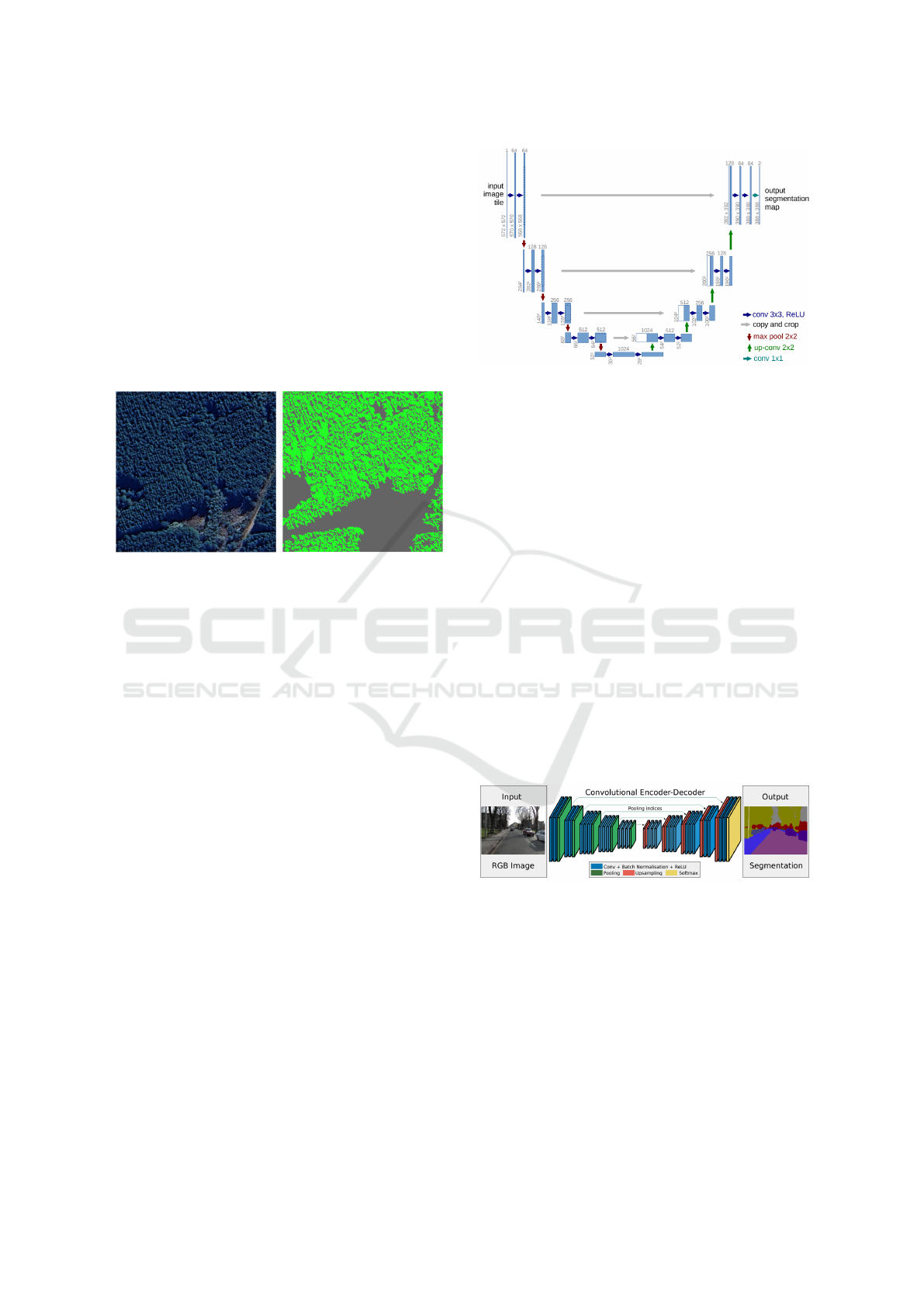
performed, as illustrated in Figure 1.
Figure 1: Example of a satellite image and its respective
mask.
As shown in the figure above, the entire area con-
taining Pinus in the satellite image was labeled using
the color green, while the rest was labeled with the
color gray.
3.4 Algorithms Used
Three image segmentation algorithms were used for
this work: U-Net, SegNet, and FCN. The models
were implemented using the Keras and TensorFlow
libraries.
3.4.1 U-Net
The U-Net algorithm was chosen for its ability to use
data augmentation layers to achieve superior perfor-
mance compared to more robust models that require
a large amount of data (Ronneberger et al., 2015).
Although U-Net is frequently used in medical image
segmentation, such as in tumor detection, it can also
be adapted for other segmentation domains. Figure 2
illustrates the U-Net architecture as proposed by Ron-
neberger et al.
Following the same structure as the original
model, only a few adaptations were made, such as re-
ducing the number of filters in each layer (the origi-
nal model ranges from 64 to 1024 filters, while this
research used between 16 and 256 filters) due to the
reduced size of the dataset. This modification helped
Figure 2: Each blue box corresponds to a multi-channel fea-
ture, with its value displayed on top of it.
save time and computational effort.
3.4.2 SegNet
The second model chosen was SegNet, designed for
pixel-by-pixel semantic segmentation. SegNet is a
trainable segmentation architecture that consists of
an encoding network, a corresponding decoding net-
work, and a pixel-by-pixel classification layer. The
architecture of the encoding network is topologi-
cally identical to the 13 convolutional layers of the
VGG16 network (Simonyan and Zisserman, 2015).
This model stands out for its robustness, requiring
a larger amount of data to achieve optimized perfor-
mance, and was primarily developed for scene under-
standing. It is efficient in terms of memory and com-
putational time, even when compared to other robust
architectures (Badrinarayanan et al., 2015). Figure 3
shows the original SegNet architecture, as proposed
by Badrinarayanan et al.
Figure 3: SegNet Architecture. This network is fully con-
volutional, meaning there are no fully connected layers.
For this research, fewer filters were used in the
encoding and decoding layers, starting with 32 fil-
ters instead of the 64 filters used in the original ver-
sion. Additionally, the upsampling method with poo-
ling indices was replaced by Conv2dTranspose to re-
duce computational cost. The activation function
in the output layer was modified to sigmoid, com-
monly used in binary classifications, while the ori-
ginal model uses softmax, typically used in multiclass
classifications.
Exploring Machine Learning and Remote Sensing Techniques for Mapping Pinus Invasion Beyond Crop Areas
875

3.4.3 FCN
The last model chosen was a Fully Convolutional Net-
work (FCN), which is a fully convolutional model
designed for pixel-by-pixel segmentation, similar to
the SegNet model. FCNs stand out for their ability
to handle images of any size, producing segmenta-
tion maps with the same dimensions as the input,
which is crucial for detailed segmentation (Shelhamer
et al., 2015). These networks maintain spatial reso-
lution throughout the segmentation process by repla-
cing fully connected layers with convolutional layers
and using upsampling techniques to reconstruct the
original resolution of the image. This design allows
the FCN to be trained in an end-to-end manner, sim-
plifying the training process and directly optimizing
the segmentation task. Figure 4 demonstrates the ba-
sic architecture of an FCN.
Figure 4: Example of an FCN architecture. All layers are
convolutional, forming a pixel-by-pixel final prediction.
In the implemented FCN model, the architecture
includes two initial convolutional layers followed by
pooling layers, which reduce the image resolution.
Then, a fully convolutional part reconstructs the ori-
ginal resolution of the image. The use of Conv2D
layers with ReLU activation and UpSampling2D lay-
ers helps create a detailed reconstruction of the ima-
ge’s features. The final Conv2D layer with sigmoid
activation is used to generate the segmentation map,
suitable for binary classification tasks.
3.5 Metrics Used
For this project, four commonly used evaluation me-
trics in classification were chosen: Accuracy, Jac-
card coefficient, recall, precision, and confusion ma-
trix. All the metrics used were implemented using the
Scikit-learn library.
3.6 Results and Discussion
After training and prediction on the test dataset, the
results suggest a higher accuracy rate for the deep
neural network U-Net compared to the other models.
As seen in Table 1, the accuracy results of the three
models were very close, with the SegNet network
achieving the highest result at 82.84%. Regarding
the Jaccard metric, the discrepancy between the re-
sults became more significant, with the U-Net model
achieving 69.62%, the highest result, followed by
SegNet at 45.93% and FCN at 29.17%, which was the
lowest result. In terms of recall, the results showed
some differences, with SegNet achieving the highest
result at 58.34%, U-Net at 41.19%, and FCN at only
34%, which again was the lowest result. Finally, the
precision results were relatively close, with U-Net
achieving 78.47%, SegNet at 68.35%, and FCN with
the worst result at 67.21%.
Table 1: Model results on the test database.
Models Accuracy Jaccard Recall Precision
U-Net 82,49% 69,62% 41,19% 78,47%
SegNet 82,84% 45,93% 58,34% 68,35%
FCN 79,37% 29,17% 34,00% 67,21%
The following figures present the segmentation of
the best prediction from each model. It is notable the
significant difference in the Jaccard metrics, where U-
Net consistently achieves the highest similarity to the
ground truth. This model is able to disregard a large
amount of vegetation that was not classified as Pinus,
in contrast to the competing models.
Figure 5: U-Net model segmentation.
Figure 6: SegNet model segmentation.
Figure 7: FCN model segmentation.
VISAPP 2025 - 20th International Conference on Computer Vision Theory and Applications
876
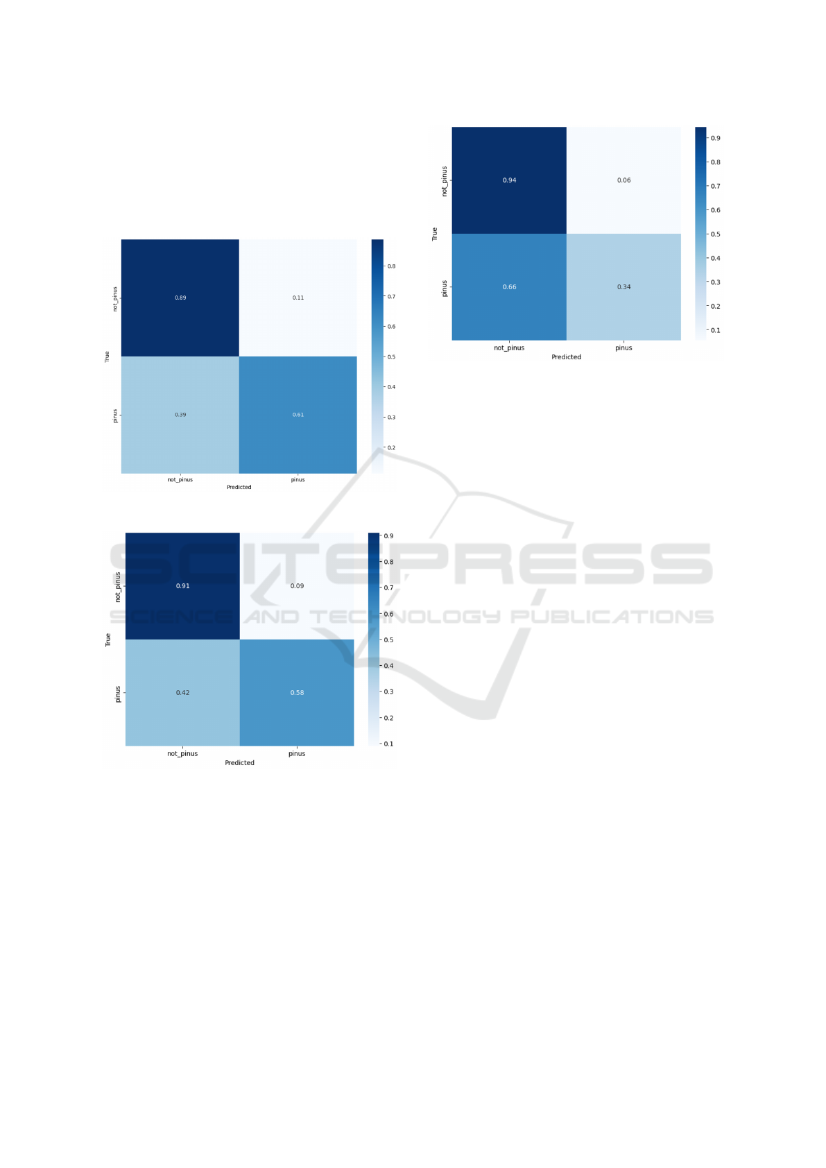
Finally, by visualizing the following figures con-
taining the confusion matrix for each model, it is evi-
dent that U-Net outperforms the others. It is possible
to observe that this network correctly predicts 89% of
the true negative label samples (non-Pinus spp.) and
63% of the true positive samples.
Figure 8: U-Net confusion matrix.
Figure 9: SegNet confusion matrix.
Comparing the results obtained by the U-Net
model, which showed the best performance, with
studies in similar domains, such as the work by So
and Yokota (So and Yokota, 2024), aimed at mapping
the distribution of alien species in river embankments,
and the study by Zhang et al. (Zhang et al., 2023a),
which focused on mapping the distribution of trees in
the Beijing Plain reforestation project, a notable diffe-
rence in the choice of datasets and methodologies for
each situation can be observed.
So and Yokota (So and Yokota, 2024) used
WorldView-3 satellite images fused with drone ima-
Figure 10: FCN confusion matrix.
gery, demonstrating how data fusion can enhance spa-
tial resolution and mapping accuracy. This method re-
sulted in high overall accuracy (98.39% for Solidago
and 97.78% for Sorghum halepense), proving to be
an effective approach for river embankment environ-
ments.
On the other hand, Zhang et al. (Zhang et al.,
2023a) applied a three-level hierarchical approach,
using sources such as Pl
´
eiades-1B, WorldView-2, and
Sentinel-2 combined with algorithms like SVM and
Random Forest. This method achieved varying results
depending on forest heterogeneity, with Sentinel-
2 being effective for homogeneous forests (OA of
89.29%) and WorldView-2 excelling in mixed forests
(OA of 90.91%).
The three studies analyzed demonstrate the effec-
tiveness of remote sensing and machine learning al-
gorithms in different contexts. While So and Yokota
emphasize the use of data fusion for high spatial reso-
lution, Zhang et al. explore hierarchical combinations
of data and algorithms. This article aims to highlight
the usefulness of deep neural networks for mapping
specific species.
4 CONCLUSION
The U-Net model demonstrated the best performance
among the three, especially excelling in the metrics
most relevant to this research, where the primary goal
is to correctly classify true positives (Pinus spp.). This
is evident from its confusion matrix, which showed
the highest number of correct predictions. While the
accuracy of all models was satisfactory, it is important
to note that a significant portion of this value is at-
tributed to the classification of the true negative class
(non-Pinus spp.), which is not the focus of this work.
Exploring Machine Learning and Remote Sensing Techniques for Mapping Pinus Invasion Beyond Crop Areas
877
This imbalance in the dataset highlights an impor-
tant limitation: the data used in this study is not ba-
lanced with the non-Pinus spp. class being dispro-
portionately represented. As a result, the models tend
to achieve higher precision and accuracy by correctly
identifying the dominant class, even if their perfor-
mance on the minority class (Pinus spp.) remains less
robust.
That limitation is particularly reflected in the Jac-
card metrics, which provide a more nuanced evalua-
tion of model performance by considering both false
positives and false negatives. Among the models,
only U-Net achieved a superior result in this me-
tric, underscoring its effectiveness in identifying areas
dominated by Pinus spp. despite the dataset’s imba-
lance.
The dataset used in this project is publicly avai-
lable for use, making it a valuable resource for re-
searchers interested in advancing methodologies for
the classification and monitoring of exotic tree species
in similar contexts. For now, the preliminary results
are promising, and in the future, new approaches will
be explored to improve the results.
ACKNOWLEDGMENT
The authors gratefully acknowledge the support provided
by:
REFERENCES
Aparecido de Almeida, C., Nigri Happ, P., Ortega Adarme,
M., Queiroz Feitoza, R., and Rodrigues Gomes, A.
(2020). Avaliac¸
˜
ao de t
´
ecnicas de aprendizagem pro-
funda para detecc¸
˜
ao de desmatamentos na regi
˜
ao da
amaz
ˆ
onia e cerrados brasileiros. Remote Sensing,
12(6):1024–1038.
Badrinarayanan, V., Kendall, A., and Cipolla, R. (2015).
Segnet: A deep convolutional encoder-decoder archi-
tecture for image segmentation. IEEE Transactions on
Pattern Analysis and Machine Intelligence, 39:2481–
2495. Available at: https://api.semanticscholar.org/
CorpusID:60814714. Accessed on: September 17,
2024.
Beloiu, M., Gessler, A., Griess, V. C., Heinzmann, L., and
Rehush, N. (2023). Individual tree-crown detection
and species identification in heterogeneous forests us-
ing aerial rgb imagery and deep learning. Remote
Sensing, 15(5):1463. Available at: https://doi.org/10.
3390/rs15051463. Accessed on: September 23, 2024.
Brandt, J. and Stolle, F. (2020). A global method to identify
trees outside of closed-canopy forests with medium-
resolution satellite imagery. International Journal
of Remote Sensing, 42(5):1713–1737. Available at:
https://doi.org/10.1080/01431161.2020.1841324. Ac-
cessed on: September 23, 2024.
Cervi, A. C., Linsingen, L. v., Hatschbach, G., and
Ribas, O. S. (2007). A vegetac¸
˜
ao do parque es-
tadual de vila velha, munic
´
ıpio de ponta grossa,
paran
´
a, brasil. Boletim do Museu Bot
ˆ
anico
Municipal, 69:1–52. Available at: https:
//www.researchgate.net/publication/313642957
A vegetacao do Parque Estadual de Vila Velha
Municipio de Ponta Grossa Parana Brasil.
Handan-Nader, C., Ho, D. E., and Liu, L. Y. (2021).
Environmental Enforcement: Enhancing the Role of
Satellite Imagery and Deep Learning. Stanford Law
School. Publication date: June 7, 2021; Date created:
2021; Date modified: August 10, 2021; December 5,
2022.
Instituto
´
Agua e Terra (2024). Estado regulamenta cultivo
de pinus e outras plantas ex
´
oticas invasoras no paran
´
a.
Accessed on December 16, 2024.
Li, J., Pei, Y., Zhao, S., Xiao, R., Sang, X., and Zhang, C.
(2020). A review of remote sensing for environmen-
tal monitoring in china. Remote Sensing, 12(7):1130.
Submission received: 17 February 2020; Revised: 27
March 2020; Accepted: 30 March 2020; Published: 2
April 2020.
Li, W., Dong, R., Fu, H., and Yu, L. (2019). Large-scale oil
palm tree detection from high-resolution satellite im-
ages using two-stage convolutional neural networks.
Remote Sensing, 11(1):11. Submission received: 2
November 2018; Revised: 2 December 2018; Ac-
cepted: 19 December 2018; Published: 20 December
2018.
Nascente, J. C. and Nunes, G. M. (2020). Uso de sis-
temas de aeronaves remotamente pilotadas (rpas) na
quantificac¸
˜
ao de incremento anual em volume de
aterro sanit
´
ario. Revista Brasileira de Gest
˜
ao Ambi-
ental e Sustentabilidade, 7(16):665–678. Published
on: August 31, 2020.
QGIS. Qgis geographic information system. Open Source
Geospatial Foundation Project. Available at: https://
qgis.org. Accessed on: September 17, 2024.
Qian, Y., Qin, H., Wang, W., Xiong, X., Yao, Y., and Zhou,
W. (2023). Detecting dominant tree species in urban
areas using zhuhai-1 satellite imagery. Journal of Ap-
plied Remote Sensing, 17(2):289–300.
Ronneberger, O., Fischer, P., and Brox, T. (2015).
U-net: Convolutional networks for biomedi-
cal image segmentation. ArXiv. Available at:
https://api.semanticscholar.org/CorpusID:3719281.
Accessed on: September 17, 2024.
Shelhamer, E., LONG, J., and Darrell, T. (2015). Fully
convolutional networks for semantic segmentation.
In IEEE Conference on Computer Vision and Pat-
tern Recognition (CVPR), pages 3431–3440. Avail-
VISAPP 2025 - 20th International Conference on Computer Vision Theory and Applications
878

able at: https://api.semanticscholar.org/CorpusID:
1629541. Accessed on: September 17, 2024.
Simonyan, K. and Zisserman, A. (2015). Very deep convo-
lutional networks for large-scale image recognition.
So, M. R. and Yokota, S. (2024). Alien species distribution
mapping using satellite and drone fusion on river dikes
along the tone river, japan. Journal of Applied Remote
Sensing, 18(4):044505–044505.
Usman, M., Ejaz, M., Nichol, J. E., Farid, M. S., Abbas,
S., and Khan, M. H. (2023). A comparison of ma-
chine learning models for mapping tree species using
worldview-2 imagery in the agroforestry landscape
of west africa. ISPRS International Journal of Geo-
Information, 12(4):142. Submission received: 25 Jan-
uary 2023; Revised: 19 March 2023; Accepted: 22
March 2023; Published: 25 March 2023.
Zhang, S., Cui, Y., Zhou, Y., Dong, J., Li, W., Liu, B.,
and Dong, J. (2023a). A mapping approach for euca-
lyptus plantations canopy and single-tree using high-
resolution satellite images in liuzhou, china. IEEE
Transactions on Geoscience and Remote Sensing.
Zhang, X., Yu, L., Zhou, Q., Wu, D., Ren, L., and Luo, Y.
(2023b). Detection of tree species in beijing plain af-
forestation project using satellite sensors and machine
learning algorithms. Forests, 14(9):1889. Submis-
sion received: 10 August 2023; Revised: 7 September
2023; Accepted: 15 September 2023; Published: 17
September 2023. This article belongs to the Special
Issue Mapping Forest Vegetation via Remote Sensing
Tools.
Zheng, J., Wu, W., Yu, L., and Fu, H. (2021). Coconut
trees detection on the tenarunga using high-resolution
satellite images and deep learning. In 2021 IEEE In-
ternational Geoscience and Remote Sensing Sympo-
sium IGARSS, pages 6512–6515.
Exploring Machine Learning and Remote Sensing Techniques for Mapping Pinus Invasion Beyond Crop Areas
879
