
S34I Project: Secure and Sustainable Supply of Raw Materials for
EU Industry
Ana Cláudia Teodoro
1 a
, Joana Cardoso-Fernandes
1 b
, Mihaela Gheorghe
2 c
,
Francesco Falabella
3 d
, Fabiana Calò
3 e
, Antonio Pepe
3 f
, Delira Hanelli
4 g
,
Andreas Knobloch
4 h
, Roberto De La Rosa
4 i
, Fahimeh Farahnakian
5,6 j
,
Georgios Periklis Georgalas
7 k
, Enoc Sanz-Ablanedo
8 l
, Vaughan Williams
9
, Krištof Oštir
10 m
1
Instituto de Ciências da Terra, Departamento de Geociências, Ambiente e Ordenamento do Território, Faculdade de
Ciências, Universidade do Porto, Porto, Portugal
2
GMV Innovating Solutions SRL, Bucharest, Romania
3
CNR - National Research Council of Italy, Institute for the Electromagnetic Sensing of the Environment, Napoli, Italy
4
Beak Consultants GmbH, Freiberg, Germany
5
Geological Survey of Finland (GTK), Espoo, Finland
6
Department of Computing, University of Turku, Turku, Finland
7
Department of General Geology, Geological Mapping & Applications, Hellenic Survey of Geology & Mineral Exploration,
Acharnae, Attica, Greece
8
Grupo de Investigación en Geomática e Ingeniería Cartográfica (GEOINCA), Universidad de León, León, Spain
9
Aurum Exploration Ltd, Ireland
10
University of Ljubljana, Faculty of Civil and Geodetic Engineering, Ljubljana, Slovenia
Keywords: Exploration, Extraction, Environmental Monitoring, Remote Sensing, Artificial Intelligence.
Abstract: The Secure and Sustainable Supply of Raw Materials for EU Industry – S34I project is researching and
innovating new data-driven methods to analyze Earth Observation (EO) data, supporting systematic mineral
exploration and continuous monitoring of extraction, closure, and post-closure activities to increase European
autonomy regarding raw materials (RM) resources, and to use EO not only for the management of technical
and environmental issues for a green transition but also to support public awareness, mining's social
acceptance, and better legislation. S34I uses data from satellites, airborne, unmanned aerial vehicles, ground-
based sensors, underwater hyperspectral imaging and conventional in-situ techniques/methods and fieldwork.
The S34I project is supporting the technical experiments and pilot validations/demonstrations for the six pilot
use cases and at different phases of the mining life-cycle to address the challenges of the topic: Onshore
exploration (Aramo in Spain); Shallow water exploration (Ria de Vigo in Spain); Extraction (Gummern in
Austria); and Closure/post-closure (Lausitz in Germany, Aijala and Outokumpu in Finland). The S34I project
involves 19 partners from 12 European countries. The project started in January 2023 and ends in June 2025.
a
https://orcid.org/0000-0002-8043-6431
b
https://orcid.org/0000-0001-8265-3897
c
https://orcid.org/0000-0001-8171-6411
d
https://orcid.org/0000-0002-3698-908X
e
https://orcid.org/0000-0002-0174-5894
f
https://orcid.org/0000-0002-7843-3565
g
https://orcid.org/0009-0002-0012-1729
h
https://orcid.org/0000-0001-7515-001X
i
https://orcid.org/0000-0002-3004-7104
j
https://orcid.org/0000-0002-7672-9346
k
https://orcid.org/0009-0003-1180-2519
l
https://orcid.org/0000-0001-9975-5726
m
https://orcid.org/0000-0002-4887-7798
Teodoro, A. C., Cardoso-Fernandes, J., Gheorghe, M., Falabella, F., Calò, F., Pepe, A., Hanelli, D., Knobloch, A., De La Rosa, R., Farahnakian, F., Georgalas, G. P., Sanz-Ablanedo, E.,
Williams, V. and Oštir, K.
S34I Project: Secure and Sustainable Supply of Raw Materials for EU Industry.
DOI: 10.5220/0013470500003935
Paper published under CC license (CC BY-NC-ND 4.0)
In Proceedings of the 11th International Conference on Geographical Information Systems Theory, Applications and Management (GISTAM 2025), pages 277-285
ISBN: 978-989-758-741-2; ISSN: 2184-500X
Proceedings Copyright © 2025 by SCITEPRESS – Science and Technology Publications, Lda.
277
1 INTRODUCTION
Sustainable mining practices, i.e., the minimization of
environmental damage, social responsibility,
reduction of ecological footprints, rehabilitating
mined land, managing waste effectively, and
conserving biodiversity, are a very hot topic and have
been a concern for many years (Laurence, 2011; Chen
et al., 2024).
The Critical Raw Materials Act (CRMA),
proposed by the European Commission, seeks to
address the challenges faced by the European Union
(EU) in securing a stable and sustainable supply of
critical raw materials (European Commission, 2023).
Its primary goal is to reduce the EU's reliance on
external sources for these materials while ensuring
their availability to support strategic sectors,
including those vital for decarbonization and
advancing green technologies (Hool et al., 2024). The
Act sets several benchmarks by 2030 along the
strategic raw materials value chain and for the
diversification of the EU supplies: (i) at least 10% of
the EU's annual consumption for extraction; (ii) at
least 40% of the EU's annual consumption for
processing; and (iii) at least 25% of the EU's annual
consumption for recycling no more than 65% of the
EU's annual consumption from a single third country.
Satellite data is crucial in sustainable mining
practices by offering tools and insights to minimize
environmental impact, optimize operations, and
ensure compliance with sustainability standards
(Farahnakian et al., 2024; Li et al., 2023; Persello et
al., 2022).
Regarding the applications of satellite data in
sustainable mining, using these data and image-
processing techniques reduces the environmental
impact by identifying high-potential areas remotely
(Rajan Girija & Mayappan, 2019). Remote sensing
has the ability to help exploration companies explore
much larger and often more remote and inaccessible
areas whilst at the same time focusing time and costs
on identifying specific target areas for further testing
(Pour et al., 2019; Beiranvand Pour et al., 2018). This
will lead to more efficient timelines for discovery.
Mineral mapping can analyze mine waste (tailings)
for recoverable resources, turning waste into reusable
materials and reducing the need for fresh extraction
(Gulicovski et al., 2024; Rodríguez-Hernández et al.,
2019; Zoran et al., 2009).
The recent advances in Artificial Intelligence (AI)
algorithms and Earth Observation (EO) free data are
aspects that broadly support several Sustainable
Development Goals and promote sustainable mining
(Chen et al., 2024; Persello et al., 2022).
The S34I project has explored new data-driven
methods to analyze EO data for systematic mineral
exploration, continuous extraction monitoring,
closure and post-closure activities, increasing
European autonomy regarding raw materials
(Farahnakian et al., 2024; Carvalho et al., 2025). The
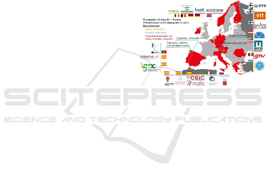
consortium is composed of 19 partners from 12
countries (11 from the EU, plus Norway) (see Figure
1). The partners are 50% from academia and national
research centres and 50% from private
companies/industries. The project started in January
of 2023 and will end in June 2025.
Figure 1: S34I project partners.
The main objective of this work is to present the
project's main objectives and some preliminary
results. The project tackles the entire mining life cycle
(exploration, extraction, mine closure) by focusing on
six distinct pilot sites. Each mining phase and pilot
presents different challenges that were addressed
using EO data and techniques. This work will
summarize the S34I approach to address these
challenges. First, all datasets used in S34I will be
listed according to the mining phase. Then, an
overview of the methods developed/adapted in the
scope of S34I will be given. Preliminary results will
be presented and discussed for selected methods.
These methods and results will serve as a base to
develop specific services to address the identified
challenges.
2 DATA
S34I utilized data from Copernicus missions and
Copernicus Contributing Missions (CCM) obtained
from the European Space Agency and other satellite
sensors, while additional platforms, which included
airborne systems, unmanned aerial vehicles (UAVs),
ground-based methods, in-situ techniques, and
S34I 2025 - Special Session on S34I - From the Sky to the Soil
278
fieldwork, were employed for calibration, validation,
or to complement the satellite data. The data used
varied depending on the mining phase and pilot site:
▪ Exploration Phase - Onshore Pilot (Aramo
Mine, Spain): Sentinel-1, Sentinel-2, Landsat-
9, Hyperspectral Precursor of the Application
Mission (PRISMA), Advanced Land
Observing Satellite (ALOS) Phased Array type
L-band Synthetic Aperture Radar (PALSAR)-
2, Constellation of Small Satellites for
Mediterranean basin Observation (COSMO-
SkyMed), airborne Light Detection and
Ranging (LiDAR), hyperspectral data, and
ground spectral libraries of rocks and soils.
▪ Exploration Phase - Shallow Waters Pilot (Rias
Baixas, Spain): Sentinel-1, Sentinel-2,
Landsat-9, WorldView-2/-3, EnMap,
Underwater Hyperspectral Imaging (UHI),
complementary spectral libraries, and pre-
existing or newly acquired geological data.
▪ Extraction Phase (Gummern, Austria):
Pléiades Neo tri-stereo, WorldView-2,
Sentinel-1, Sentinel-2, COSMO-SkyMed,
UAV data, and ground Global Navigation
Satellite Systems (GNSS) stations.
▪ Closure and post-closure Phase (Lausitz and
Outokumpu): Sentinel-2, PRISMA,
WorldView-3, UAV data, and geochemical
water data; and Sentinel-1, Sentinel-2, and
COSMO-SkyMed data (Aijala).
It should be noted that the S34I consortium
worked together with the holders of the rights for
exploration in Aramo and for exploitation in
Gummern.
3 METHODS
The data and methodology employed in the S34I
project depend on the pilot case and the mining phase
addressed. However, the principal outcomes of the
S34I project focus on processing Copernicus and
CCM data.
Several approaches were applied and developed,
from traditional methods to new ensemble machine
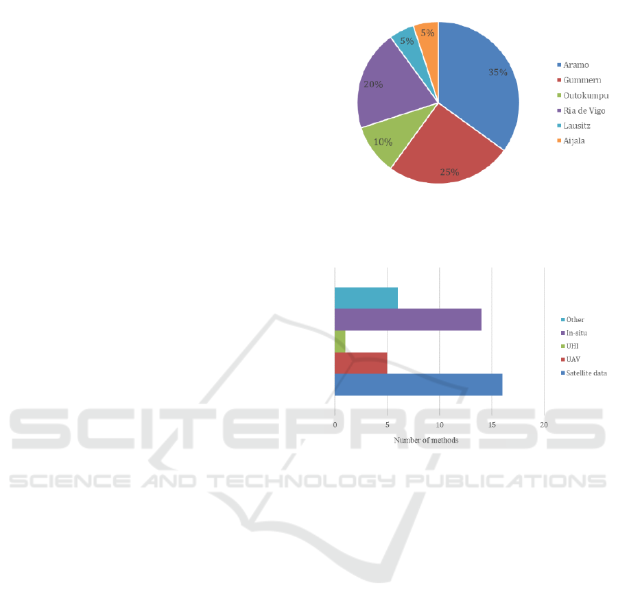
learning (ML) algorithms. Figure 2 presents the
methods developed in the primary pilot area. The
techniques have been developed in a specific location
but later implemented in other pilot areas.
The methods were developed according to the
type of EO data exploited (satellite and other data), as
shown in Figure 3.
Figure 2: Developed methods according to the primary pilot
area.
Figure 3: Developed methods according to the data.
3.1 Exploration Phase
For the onshore pilot (Aramo, Spain), various
analytical methods were employed, including RGB
combinations, band ratios, Principal Component
Analysis (PCA), K-means clustering, end-member
extraction, minimum wavelength mapping, Spectral
Angle Mapper (SAM), Self-Organizing Maps
(SOM), and Artificial Neural Networks (ANNs). A
novel ensemble AI method was developed by
integrating Support Vector Machines (SVM),
Random Forest (RF), and ANNs. Additionally, a
specialized AI algorithm was designed for automated
pre-processing of hyperspectral airborne data,
requiring minimal ground truth input. This was aided
by pre-existing geochemical datasets, which
minimized the requirement for a large part of follow-
up ground truthing.
In the shallow water exploration pilot (Rias
Baixas, Spain), RGB combinations, band ratios,
PCA, K-means clustering, spectral unmixing, and
Object-Based Image Analysis (OBIA) enhanced
feature detection and classification.
S34I Project: Secure and Sustainable Supply of Raw Materials for EU Industry
279
3.2 Extraction Phase
In the extraction pilot (Gummern, Austria), high-
resolution Digital Elevation Models (DEMs) were
generated, and UAV photogrammetry was effectively
performed using Structure from Motion (SfM) for
detailed surface modelling.
Interferometric Synthetic Aperture Radar
(InSAR) and change detection techniques, including
the Normalized Decorrelation Change Index (NDCI),
were applied to Synthetic Aperture Radar (SAR) data
for detailed surface analysis. Additionally, advanced
AI models—Residual-in-Residual Dense Block
(RRDB), Super-Resolution U-Net (SRUN), and
Optical-Guided Super-Resolution Network
(OGSRN)—were implemented to enhance the
resolution and quality of SAR imagery.
A Low-cost GNSS Monitoring System (LGMS)
using low-cost GNSS receivers to monitor
displacements with high precision was implemented.
The LGMS receives and stores GNSS observations
continuously, which are later post-processed to
estimate daily displacements of the monitoring
locations.
3.3 Closure and Post-Closure Phase
For closed mines affected by Acid Mine Drainage
(AMD) (Lausitz, Germany and Outokumpu,
Finland), unsupervised learning methods such as
SOM and K-means clustering were utilized for
pattern recognition and data analysis. Supervised
classification techniques were applied to improve
predictive accuracy, including ANN, logistic
regression, RF, and K-nearest Neighbors (KNN).
Additionally, image enhancement and change
detection techniques were implemented at the Aijala
pilot (Finland).
4 RESULTS AND DISCUSSION
In this section, some preliminary results will be
presented and discussed.
4.1 Exploration Phase
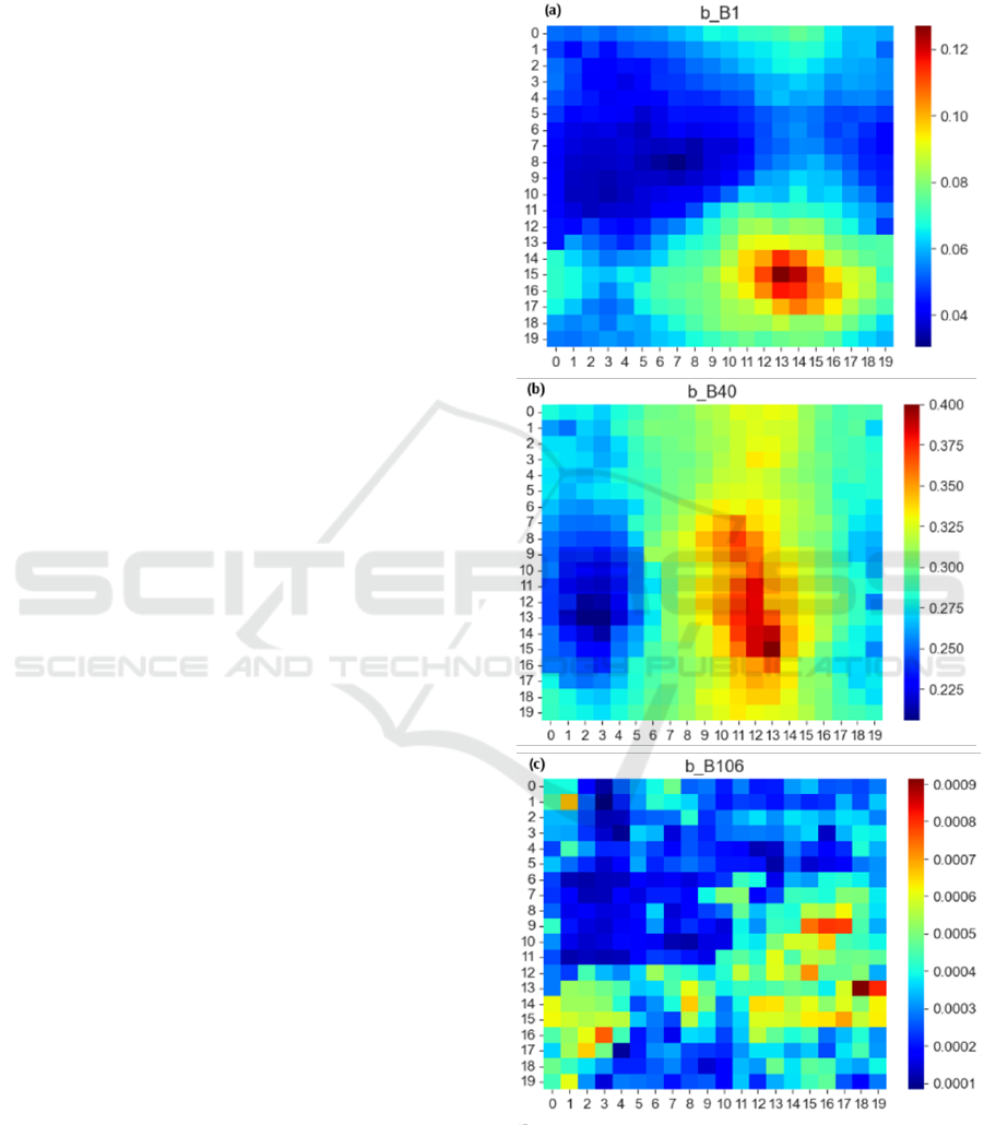
In the onshore pilot study, SOM was applied for data
exploration to analyze geochemical sample points. A
K-means clustering algorithm was also applied to the
SOM output to categorize the data into distinct
clusters. This combination allows for identifying
meaningful groupings and enhances the
interpretability of spatial and spectral patterns.
Ultimately, it improves understanding of Cobalt (Co)
distribution captured by PRISMA and LiDAR data
(Figure 4).
Figure 4: SOM results from geochemical sample points of
PRISMA: (a-c) Example variable SOMs related to the band
information (band 1, 40 and 106).
S34I 2025 - Special Session on S34I - From the Sky to the Soil
280
A new ensemble AI method was developed by
integrating SVM, RF, and ANN to exploit different
satellite-based datasets. Emphasis was given to
Copernicus data (Sentinel-2), Landsat-9 and
PRISMA, combining multispectral and hyperspectral
images. This classifier ensemble method employed a
Soft Voting strategy. The ensemble classifier shows
variable performance with different input data.
PRISMA data allows for better class separability, but
the model tends to overfit, indicating the need for
better regularisation (Figure 5).
Figure 5: Examples of prediction map of hydrothermal
alteration area (coloured pixels) generated from PRISMA
dataset on the onshore exploration phase.
A spectral library was created, including 311
samples of outcropping rocks, 371 samples of soils,
and 208 samples from the old mine in Aramo. The
mineralogical associations corresponding to the
outcropping rocks and soils in the Aramo Plateau,
their spectral signatures in the SWIR region and their
relationship with the contents of Co and other
elements (Nickel (Ni) and Copper (Cu)) were
determined. Although no clear spectral signature for
Co was identified, the study successfully defined nine
distinct spectral signatures from the 11 mineralogical
associations. This could be mainly attributed to the
fact that the deposit is mainly enriched in Cu, but with
associated Cu and Ni. Additionally, statistical
correlations between mineralogical associations and
geochemical data revealed that specific associations
showed a higher probability of containing elevated
Co, Ni, and Cu levels.
A method was also developed for pre-processing
airborne hyperspectral data. This involves converting
digital counts from hyperspectral sensors into
radiance values through several key steps. Geometric
correction ensures that image pixels correspond to
their correct geographic locations, while atmospheric
correction mitigates the effects of the atmosphere,
such as absorption and scattering, on the measured
radiance. Additionally, spectral calibration ensures
precise wavelength alignment to match known
spectral features. A semi-automated workflow was
implemented for the large-scale interpretation of
hyperspectral data, integrating satellite, airborne
platforms and UAVs, combined with ground
spectroradiometer measurements to automate
extracting meaningful features for geological
interpretation.
A methodology for utilizing EO data from
airborne and/or UAVs to develop predictive mineral
maps for the Aramo plateau during the exploration
mining phase was also developed.
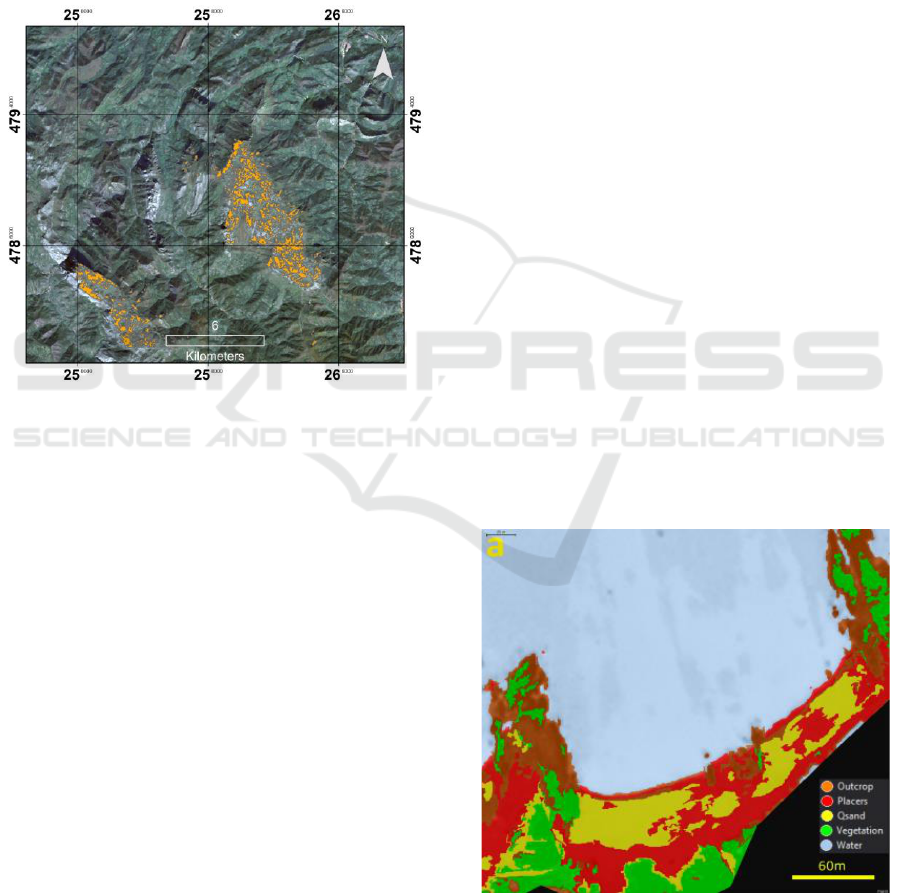
Regarding the shallow waters pilot, a methodology
was developed for identifying placer deposits using an
OBIA and high-resolution satellite data. This analysis
revealed distinct signatures for each material within the
spectral resolution of the WorldView-3 satellite data,
leading to the creation of a new band ratio for
prospective deposit categorization (VNIR1-VNIR4
band ratio to identify Ilmenite) and one for determining
the geological background from vegetation (VNIR6-
VNIR8). Three different ML approaches are developed
and compared with each other: a single-level model
using the SVM algorithm, a multi-level model using
the KNN algorithm, and a dynamic classification
developed with a decision tree model. The outcome of
implementing these methods is the production of maps
illustrating the distribution of placer deposits within the
coastal area of Vigo, which can be seen in Figure 6.
Figure 6: Examples of prediction map generated using
Single-level OBIA on the WorldView-3 dataset on the
shallow waters pilot.
S34I Project: Secure and Sustainable Supply of Raw Materials for EU Industry
281
We also applied an innovative UHI for shallow
water exploration to identify potential areas for the
occurrence of CRMs. UHI data was acquired with
field work and refers to three different sea zones in
Ria de Vigo, along with seabed samples from the
same areas. The methodology centres on the Mixture
Tuned Matched Filtering (MTMF) algorithm to map
seabed targets by matching known spectral signatures
with UHI data. It also identified sediments with
spectral signatures consistent with placer deposits
found on Ria de Vigo beaches.
Finally, we integrate traditional geological
methodologies with EO techniques for delineating
CRM prospective areas for placer deposits.
4.2 Extraction Phase
The experimental results include images at a global
scale, as collected in the Sentinel-1 and -2 datasets.
All models' performance was evaluated using PSNR
(Peak Signal-to-Noise Ratio) and SSIM (Structural
Similarity Index Measure). The Sentinel-2 enhanced
model (OGSRN) performs less than the Dense
Residual-in-Residual Dense Block (RRDB) model,
based on Sentinel-1 only. Overall, it demonstrated
how deep learning models can improve the resolution
of SAR data, showing an increase of 18% for the
PSNR score and about 2% for the SSIM score
compared to the corresponding baseline bicubic
scores.
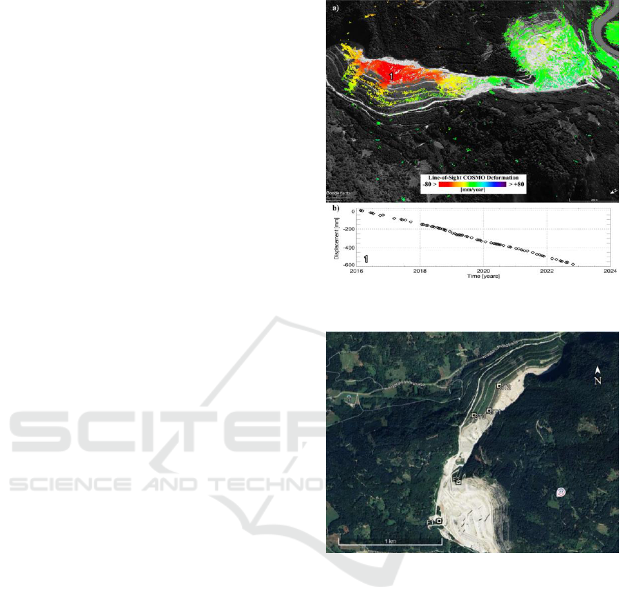
The Multigrid InSAR technique provides accurate
measurements, with millimetre accuracy, of the
ground deformations along the satellite radar line-of-
sight (LOS) direction. Combining multi-band and
multi-orbit SAR data, the obtained LOS displacement
measurements can be profitably exploited to compute
three-dimensional (3D) ground movement (Figure 7).
Deformation is due to soil compaction, so the material
added to the waste dump naturally keeps compacting.
The implementation of LGMSs at Gummern
Mine includes two stable reference points (F1 and F3)
placed on the stable ground and three observation
points (ST1, ST2, and ST3), realized with metal
poles, mounted in concrete pillars (Figure 8).
Based on the one-year testing period, it can be
stated that LGMS performed well and detected slow
movement with sub-centimetre accuracy. The results
indicated that horizontal and vertical displacements
of 10 and 20 mm occurred in ST1, while larger
displacements were noticed in ST2, which moved 25
mm horizontally and 40 mm vertically.
Figure 7: Gummern ground deformation map (a) and time
series obtained from COSMO-SkyMed (b).
Figure 8: Locations of measuring stations.
An innovative methodology was also developed
based on satellite images to continuously monitor the
life and evolution of mining waste deposits. Initially,
land surveying is conducted to establish ground
control points (GCPs). Following this, UAV flights
are undertaken to produce high-resolution DEMs.
The data acquisition process involves SfM
processing. The next stage involves acquiring new
satellite image datasets for specific epochs. For each
epoch, a different DEM and orthophoto are obtained.
Comparative analysis of successive DEMs allows
calculating geometric or volumetric changes in the
waste dumps over time. The Pléiades Neo tri-stereo
dataset was the first satellite imagery used in the
study, captured in October 2023, approximately one
month after the UAV flight. These images already
showed notable changes in the waste dump. To
S34I 2025 - Special Session on S34I - From the Sky to the Soil
282
compare the UAV-derived high-resolution DEM (HR
DEM) with the Pléiades Neo-derived DEM, the UAV
HR DEM was resampled to match the resolution of
the Pléiades Neo DEM (30 cm). WorldView-2
images, taken in April 2024, six months after the
Pléiades Neo tri-stereo images, provided an
opportunity to study changes over a longer period.
Figure 9 illustrates altitude differences between the
DEM from WorldView-2 (12. 4. 2024) and the DEM
from Pléiades Neo (1. 10. 2023). The volume changes
in the areas where waste dumping occurred are
summarized, with a total discharge volume of
101,872 m³.
Figure 9: Volumes of waste dumps between 12. 4. 2024
(DEM from Pléiades NEO) and 1. 10. 2023 (DEM from
WorldView 2).
4.3 Closure and Post-Closure Phase
Several ML algorithms were adapted to enhance pixel
classification of AMD from Sentinel 2 imagery
(Lausitz and Outokumpu) and also using space- and
airborne- multispectral and hyperspectral imagery.
SOM was also utilized to visualize and cluster high-
dimensional data to interpret complex spatial data for
AMD mapping. The study also evaluates the potential
of spaceborne hyperspectral imagery for AMD
mapping.
We also proposed ML algorithms, including RF,
KNN, Logistic Regression (LR), and MLP. They are
used to perform a pixel-based classification of the
images into AMD or non-AMD classes, as well as to
assess the severity of AMD by quantitative mapping
of AMD constituents, such as iron concentration and
pH values. The prediction map for three lakes in the
Outokumpu area is shown in Figure 10. The
visualization indicates that the RF model accurately
classified the pixels, as the lakes were primarily
contaminated by AMD rather than coastal areas.
Additionally, the SOM method was also used to
visualize and cluster high-dimensional data,
simplifying the understanding and interpretation of
complex spatial data for AMD mapping. The output
of the SOM method is grid data, such as heatmaps or
U-matrix plots, which provide insights into the
clustering and organization of the data within the grid.
The main objective was the identification of AMD-
affected areas. These experiments were conducted in
three lakes located in Outokumpu, Finland.
Figure 10: Prediction map of the best model (RF) for three
study lakes and their water samples in Outokumpu.
Finally, we perform cross-sensor analysis over
water bodies to harmonize Worldview-3 and UAV
multispectral datasets to Sentinel-2. Given the free
availability of Sentinel-2 data and the typically high
costs of high-resolution commercial EO datasets, we
propose a methodology where MLP is trained using
Sentinel-2 data over a large area in conjunction with
extensive geochemical monitoring data and the
established dependencies are applied to commercial
high-resolution datasets for targeted identification of
AMD in specific areas. This approach enables a cost-
efficient combination of free-of-charge and
commercial EO datasets for AMD mapping.
Despite the cessation of mining activities, a
sudden ground collapse in February 2017 near the
Aijala refinery highlighted ongoing environmental
risks, demonstrating the need to monitor post-closure
mining sites continuously. SAR image coherence
measures how similar two radar images of the same
area are, taken at different times. For the temporal
decorrelation analysis, we proposed calculating a new
index, the Normalized Decorrelation Change Index
(NDCI), presented in Figure 11. The method's
effectiveness was validated by comparing results with
S34I Project: Secure and Sustainable Supply of Raw Materials for EU Industry
283
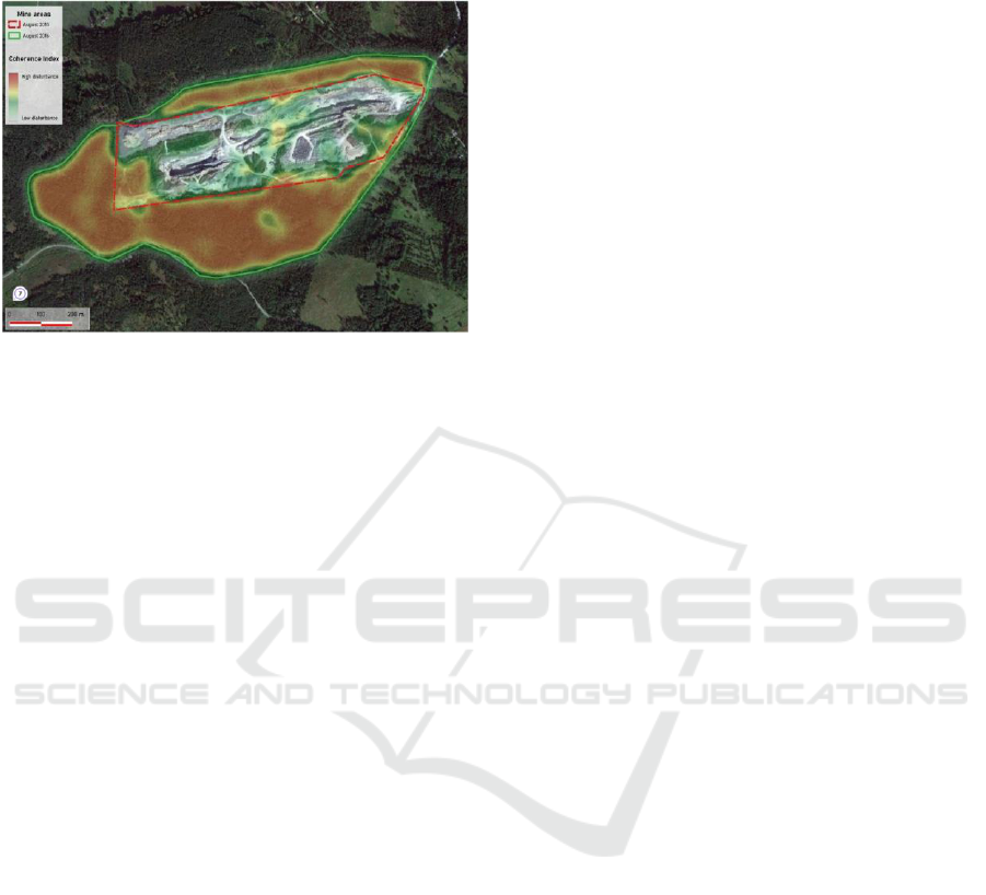
Sentinel 2A images and relevant background
information about the Aijala site.
Figure 11: NDCI depicting ongoing high disturbances in the
Aijala post-closure site between 2015-2017.
5 CONCLUSIONS
In this work, we present the preliminary results of the
S34I HORIZON project. At the moment, the methods
are being validated and verified in the pilots and also
with the end-users.
Based on the methods developed under the scope
of S34I, we prototyped EO-based services that cater
to the specific needs of mining stakeholders. These
services aim to address three key areas:
1. RM Deposits Mapping: This involves using
EO data to identify and map potential mineral
deposits, both on land and in shallow waters.
2. Early Warnings: The focus here is on
developing EO-based systems that can provide early
warnings of potential hazards at mining sites, such as
ground instability.
3. Environmental Monitoring: This
encompasses the use of EO data to monitor the
environmental impact of mining activities, such as the
detection of AMD.
In the future, these services will be available for
the stakeholders and end-users.
The result of this project will be an important step
forward in monitoring all phases of the mining cycle
using EO data, contributing to more sustainable
mining practices.
ACKNOWLEDGEMENTS
This study is funded by the European Union under
grant agreement no. 101091616
(https://doi.org/10.3030/101091616), project S34I –
Secure and Sustainable Supply of Raw Materials for
EU Industry.
REFERENCES
Beiranvand Pour, A., Park, T.-Y. S., Park, Y., Hong, J. K.,
Zoheir, B., Pradhan, B., Ayoobi, I., & Hashim, M.
(2018). Application of Multi-Sensor Satellite Data for
Exploration of Zn–Pb Sulfide Mineralization in the
Franklinian Basin, North Greenland. Remote
Sensing, 10(8), 1186.
https://doi.org/10.3390/rs10081186.
Cardoso-Fernandes, J. (2024). S34I. D4.1: Catalogue of
EO-based Prototyped Services for CRM and non-CRM
Deposits Mapping. S34I Horizon Europe GA
101091616. Available at:
https://cordis.europa.eu/project/id/101091616/results
(accessed on 15 January 2025).
Carvalho, M., Cardoso-Fernandes, J., González, F. J., &
Teodoro, A. C. (2025). Comparative Performance of
Sentinel-2 and Landsat-9 Data for Raw Materials'
Exploration Onshore and in Coastal Areas. Remote
Sensing, 17(2). doi: 10.3390/rs17020305.
Chen, L., Xie, Y., Wang, Y., Ge, S., Wang, F.Y (2024).
Sustainable Mining in the Era of Artificial Intelligence.
IEEE/CAA Journal of Automatica Sinica, 11(1), 1-4,
doi.org/10.1109/JAS.2023.124182.
European Commission (2023). European Critical Raw
Materials Act. European Commission - Press release.
https://ec.europa.eu/commission/presscorner/detail/en/
ip_23_1661. Accessed 14 January 2025.
Farahnakian, F., Luodes, N., & Karlsson, T. (2024).
Machine Learning Algorithms for Acid Mine Drainage
Mapping Using Sentinel-2 and Worldview-3. Remote
Sensing, 16(24), 4680.
https://doi.org/10.3390/rs16244680.
Gulicovski, J., Stojmenović, M., Rosić, M., Vasić, A.,
Ristović, I., Janković-Častvan, I., & Kragović, M.
(2024). Mineralogical Characterization of the Grot
Lead and Zinc Mine Tailings from Aspects of Their
Further Use as Raw Material. Applied Sciences, 14(3),
1167. https://doi.org/10.3390/app14031167.
Hool, A., Helbig, C., Wierink, G. (2024). Challenges and
opportunities of the European Critical Raw Materials
Act. Mineral Economics, 37(3), 661-668,
doi.org/10.1007/s13563-023-00394-y.
Laurence, D. (2011). Establishing a sustainable mining
operation: an overview. Journal of Cleaner Production,
19(2), 278-284, doi.org/10.1016/j.jclepro.2010.08.019.
Li, S., Wang, R., Wang, L., Liu, S., Ye, J., Xu, H., & Niu,
R. (2023). An Approach for Monitoring Shallow
Surface Outcrop Mining Activities Based on
Multisource Satellite Remote Sensing Data. Remote
Sensing, 15(16), 4062.
https://doi.org/10.3390/rs15164062.
Oštir, K. et al. (2024). S34I. D3.3: Catalogue of Innovative
New Methods to Analyze Earth Observation Data. S34I
S34I 2025 - Special Session on S34I - From the Sky to the Soil
284

Horizon Europe GA 101091616. Available at:
https://cordis.europa.eu/project/id/101091616/results
(accessed on 15 January 2025).
Persello, C., Wegner, J.D., Hänsch, R., Tuia, D., Ghamisi,
P., Koeva, M., Camps-Valls, G. (2022). Deep Learning
and Earth Observation to Support the Sustainable
Development Goals: Current approaches, open
challenges, and future opportunities. IEEE Geoscience
and Remote Sensing Magazine, 10(2), 172-200,
doi.org/10.1109/MGRS.2021.3136100, 2022.
Pour, A. B., Hashim, M., Hong, J. K., & Park, Y. (2019).
Lithological and alteration mineral mapping in poorly
exposed lithologies using Landsat-8 and ASTER
satellite data: North-eastern Graham Land, Antarctic
Peninsula. Ore Geology Reviews, 108, 112-133. doi:
https://doi.org/10.1016/j.oregeorev.2017.07.018.
Rajan Girija, R., & Mayappan, S. (2019). Mapping of
mineral resources and lithological units: a review of
remote sensing techniques. International Journal of
Image and Data Fusion, 10(2), 79–106.
https://doi.org/10.1080/19479832.2019.1589585
Rodríguez-Hernández, A., Briones-Gallardo, R., Razo, I.,
Noyola-Medrano, C., & Lázaro, I. (2016). Processing
Methodology Based on ASTER Data for Mapping
Mine Waste Dumps in a Semiarid Polysulphide Mine
District. Canadian Journal of Remote Sensing, 42(6),
643–655.
https://doi.org/10.1080/07038992.2016.1197037.
Zoran, M. A., Savastru, R. S., Savastru, D. M., Miclos, S.
I., & Tautan, M. N. M. (2009). Remote sensing
techniques for mining waste characterization. Proc.
SPIE, Remote Sensing for Environmental Monitoring,
GIS Applications, and Geology IX, 74780Q. doi:
10.1117/12.830513.
S34I Project: Secure and Sustainable Supply of Raw Materials for EU Industry
285
