
Machine Learning for Identifying Potential Photovoltaic Installations on
Parking Areas
Frederick Kistner
∗ a
and Sina Keller
∗ b
Institute of Photogrammetry and Remote Sensing (IPF), Karlsruhe Institute of Technology (KIT), Engler Street 7,
D-76131 Karlsruhe, Germany
Keywords:
Artificial Intelligence, Renewable Energy, Classification, Urban Areas, Sustainable Development, PV
Installation.
Abstract:
Integrating renewable energy systems into urban areas is crucial for sustainable development. This study as-
sesses the potential for installing photovoltaic (PV) systems in parking areas, focusing on a case study region
in Hesse, Germany. A machine learning approach is developed to classify parking lots larger than 900 m
2
into suitable and unsuitable categories. The input data includes OpenStreetMap (OSM), the Authoritative
Topographic-Cartographic Information System (ATKIS), and high-resolution geospatial datasets. A reference
dataset for the two classification categories is created. Multiple input features are generated, and their sig-
nificance for the classification task is evaluated. Additionally, several shallow machine learning models are
implemented and assessed. The XGBoost model demonstrates the highest accuracy at 99 % and is used to
classify 10, 894 parking areas throughout Hesse. Key suitability features include the Normalized Difference
Vegetation Index (NDVI), surface sealing ratios, and vegetation height. The results indicate that approximately
21.8 km
2
of the parking area is suitable for PV installations, requiring minimal ecological intervention. The
methodological approach is scalable for application in other regions, and validation in Frankfurt am Main
confirms a strong correlation with solar radiation levels. This study provides a data-driven framework for
optimizing urban energy systems and supporting sustainability initiatives.
1 INTRODUCTION
Renewable energy technologies are essential to
mitigate climate change and ensure energy secu-
rity (IPCC, 2022). Among these, photovoltaic (PV)
systems stand out due to their scalability and adapt-
ability to diverse environments (Santamouris, 2020).
The scenarios analyzed by Fraunhofer ISE (Wirth,
2023) estimate that achieving climate neutrality in
the German energy sector will require PV capaci-
ties ranging from 215 GW to 500 GW, depending on
efficiency improvements, public acceptance, and en-
ergy system dynamics. In recent decades, solar power
costs have decreased significantly, making large-scale
plants highly competitive with fossil fuels (Wirth,
2023).
When focusing on urban regions, areas functional
for PV installations are lacking. Parking lots are
generally seen as underutilized areas or stranded as-
sets, occupying substantial urban land that is mainly
nonproductive (Krishnan et al., 2017). Transforming
a
https://orcid.org/0009-0002-2601-9538
b
https://orcid.org/0000-0002-7710-5316
∗
These authors contributed equally to this work.
these areas with solar canopies offers a dual-purpose
solution that encourages using renewable energy
without requiring additional land resources (Ivanova
et al., 2020). Research indicates that PV installations
in these areas can substantially boost local energy pro-
duction and contribute to sustainable urban develop-
ment (Maier et al., 2024; Marneni et al., 2021; Krish-
nan et al., 2017).
An important question is how to identify parking
lots suitable for installing PV. Current evaluations of
parking lot solar installations often depend on gener-
alized assumptions and lack detailed, high-resolution
data. This lack can lead to overlooking local con-
straints and complicating feasibility analyses for PV
installations in different parking lot environments. It
could also eliminate parking lots, which could be
valuable for solar installations.
The proposed study addresses these emerging as-
pects. While previous studies have explored the fea-
sibility of solar energy installations in urban areas, no
existing approach combines high-resolution geospa-
tial data with machine learning (ML)–based classi-
fication to identify PV potential in parking areas.
This study introduces a novel, automated ML pipeline
244
Kistner, F. and Keller, S.
Machine Learning for Identifying Potential Photovoltaic Installations on Parking Areas.
DOI: 10.5220/0013476300003935
Paper published under CC license (CC BY-NC-ND 4.0)
In Proceedings of the 11th International Conference on Geographical Information Systems Theory, Applications and Management (GISTAM 2025), pages 244-252
ISBN: 978-989-758-741-2; ISSN: 2184-500X
Proceedings Copyright © 2025 by SCITEPRESS – Science and Technology Publications, Lda.

that leverages OpenStreetMap (OSM), the Author-
itative Topographic-Cartographic Information Sys-
tem (ATKIS), and high-resolution geospatial datasets
to systematically classify parking areas based on suit-
ability for PV installation. We apply advanced pre-
processing and feature engineering techniques to cap-
ture site-specific details. Robust classification al-
gorithms, including the XGBoost, help differentiate
suitable parking lots from unsuitable ones for PV
canopy installations. This methodological approach
goes beyond static, threshold-based filters by using
ML to manage complex, multi-dimensional data.
The main contributions of this study are summa-
rized:
1. Integration of Heterogeneous Spatial Data: We
unify datasets from OSM, ATKIS, and high-
resolution satellite imagery, including normalized
difference vegetation index (NDVI), to create a
comprehensive feature space containing descrip-
tors for each parking lot.
2. Automated Preprocessing and Feature Engi-
neering: We apply automated spatial analysis
techniques, such as buffer-based processing, high-
resolution land cover segmentation, and geomet-
ric feature extraction, to enhance data quality and
improve model performance.
3. Scalable Classification: We conduct compar-
isons of supervised machine learning models,
which are trained and evaluated on over 1, 000 la-
beled parking lot examples.
4. Generic, Transferable Framework: The
methodology is designed to be replicable, al-
lowing for broad applicability in large-scale
assessments of PV potential.
5. Independence from Solar Radiation Models: A
case study illustrates that the classification frame-
work does not rely on solar radiation models,
making it especially advantageous for regions
without such data.
6. Actionable Insights: The analysis provides de-
tailed insights into PV potential by considering
sealing rates, vegetation heights, and other park-
ing lot-specific attributes rather than relying solely
on simplified metrics such as percentage area re-
duction.
2 RELATED WORK
This section briefly introduces related work on PV
systems in parking lots and their feasibility. First, we
present the facts and benefits of installing PV systems
in parking lots. Second, we summarize the economic
and structural aspects. Lastly, we look at existing spa-
tial approaches to identify and classify suitable park-
ing lots for PV.
PV Systems in Parking Lots: Generation and Con-
sumption of Energy. In general, PV systems can
generate power close to where it is consumed, thereby
minimizing the need for extensive transmission lines.
This setup becomes particularly effective when paired
with distributed battery storage and other energy con-
verters (Wirth, 2023). Parking lots have become ideal
sites for installing decentralized photovoltaic systems.
They allow battery storage integration, which helps
ease grid congestion during peak production times
and reduces the need for long-distance transmission.
Consequently, many studies prioritize parking lots for
their land use efficiency (Maier et al., 2024; Wirth,
2023; Solar Cluster BW, 2022; Figueiredo et al.,
2017).
PV Systems in Parking Lots: Economical and
Structural Aspects. While rooftop PV solutions
are well-established, canopy structures in park-
ing lots involve additional costs for support and
retrofitting (Figueiredo et al., 2017). However, fu-
ture cost reductions and increased incentives for on-
site usage, especially when combined with the charg-
ing of electric vehicles, are expected to improve the
economic viability of such installations (Solar Clus-
ter BW, 2022; Maier et al., 2024). Although struc-
tural investments can be approximately 50 % higher
than those for standard rooftop systems, on-site self-
consumption and premium electricity pricing can off-
set these initial costs (Krishnan et al., 2017; Maier
et al., 2024). Indirect benefits include vehicle protec-
tion, extended pavement life, and a visible demonstra-
tion of commitment to climate action, strengthening
public and corporate perception (Solar Cluster BW,
2022).
Challenges in Identifying Suitable Parking Lots
for PV Installation. Generalized assumptions are
often made when focusing on existing studies and ap-
proaches to identifying potential parking lots for PV
installation. These include, for example, fixed area
coverage factors or capacity densities and a lack of
high-resolution data on shading, vegetation, or land
use constraints (Ludwig et al., 2024; Maier et al.,
2024; Krishnan et al., 2017). Besides, parking lots
vary widely in ownership structures, functional zones,
and site conditions, complicating feasibility analyses
for PV installations (Solar Cluster BW, 2022; Maier
Machine Learning for Identifying Potential Photovoltaic Installations on Parking Areas
245

et al., 2024). For example, in Germany, several fed-
eral states mandate parking PV systems for newly
constructed lots exceeding specific size thresholds, in-
fluencing scalability and business models, as shown
by (Maier et al., 2024; Ludwig et al., 2024). In ad-
dition, automated large-scale methods for identify-
ing and classifying suitable existing parking lots re-
main limited. Consequently, local limitations are of-
ten overlooked, leading to inaccurate potential assess-
ments (Wirth, 2023).
3 DATASETS
Both input and reference data are essential for creat-
ing and evaluating ML approaches to identify poten-
tial parking lots for PV installations. We detail the
reference and input data in Sections 3.2 and 3.3.
Since ensuring the feasibility and generalization
of ML models is crucial, the implementation needs
to be performed on a necessarily large actual dataset.
Therefore, we train and test the ML models on a rep-
resentative input-reference dataset that encompasses
the parking areas of the German federal state of
Hesse. In the subsequent Section 3.1, we give a brief
overview of the geographic background of Hesse.
To further validate the ML approach, we investi-
gate solar radiation information of selected parking
lots. Section 3.4 summarizes these data.
3.1 Study Region
Hesse (German: Hessen) is a federal state bordered
by six other states in west-central Germany. Its cap-
ital is Wiesbaden, and its largest city is Frankfurt am
Main, a significant financial hub. Covering around
21.114 km
2
, Hesse has a population of over six mil-
lion residents. The landscape features hilly terrain
and extensive forests, with about 42 % of its land area
covered by woodlands. The Rhine River forms the
southwestern border, contributing to its varied topog-
raphy.
To promote sustainability, the Hessian Ministry
of Economics, Energy, Transport, Housing and Ru-
ral Regions (German: Hessisches Ministerium f
¨
ur
Wirtschaft, Energie, Verkehr, Wohnen und l
¨
andlichen
Raum (HMWEVW)) claims that new parking lots
with over 50 spaces must now include solar panels,
with an expected 100 new solar-equipped lots each
year (HMWEVW, 2023).
Hesse’s central location, diverse landscape, and
innovative energy policies make it an ideal region for
developing our proposed ML models, which focus on
potential PV installations in parking areas.
3.2 Generation of Reference Parking
Lot Data
ATKIS and OSM are the primary data sources for
parking lot polygons. One advantage is that these
sources are freely available, ensuring the generaliza-
tion opportunities of the developed approach.
OSM parking areas are identified using tags
such as parking, capacity, access, surface,
rooftop. To meet the requirements according to
the Hessian Ministry of Economics, Energy, Trans-
port, Housing and Rural Regions (HMWEVW, 2023),
the minimum area of the parking lots needs to cover
900 m
2
, approximately 50 spaces. Currently, relevant
parking lots that meet the same size criteria are ex-
tracted from ATKIS. The OSM and ATKIS parking
lots have been merged, and duplicates have been re-
moved. This first step leads to 11, 281 parking objects
covering a total area of 35.88 km
2
.
For reference data generation, selected parking
lots are manually labeled and divided into two cate-
gories for PV installations: suitable and unsuitable.
This labeling process is based on high-resolution
satellite images for 1, 002 parking lots, most of which
are randomly chosen. The reference dataset com-
prises 775 suitable and 227 unsuitable parking lots.
Table 1 visualizes examples for those two classes.
Unsuitable parking lots constitute the minority class
and are significantly underrepresented in the ran-
domly selected fraction of the dataset, which posed
challenges for solving the classification task with ML
models. Therefore, additional examples of the mi-
nority class were systematically added to the dataset,
enabling more robust model training. The resulting
reference dataset comprised 22.6 % unsuitable and
77.4 % suitable parking lots stored as a geographic
layer.
3.3 Heterogeneous Input Data Sources
In addition to the generated reference data (see Sec-
tion 3.2), different input features must be extracted
from various data sources.
Since we aim to analyze the potential of installa-
tion sites in Hesse, we are built upon a comprehensive
dataset comprising various geometrical and environ-
mental factors.
The primary data source includes 11, 574 park-
ing lot objects described in Section 3.2. These park-
ing lots serve as a foundational basis for identify-
ing suitable locations for PV installations. Almost
9 % of these parking lots have labels. All parking
lots regarding the slope and orientation are investi-
gated. Excluded areas are characterized, for example,
GISTAM 2025 - 11th International Conference on Geographical Information Systems Theory, Applications and Management
246
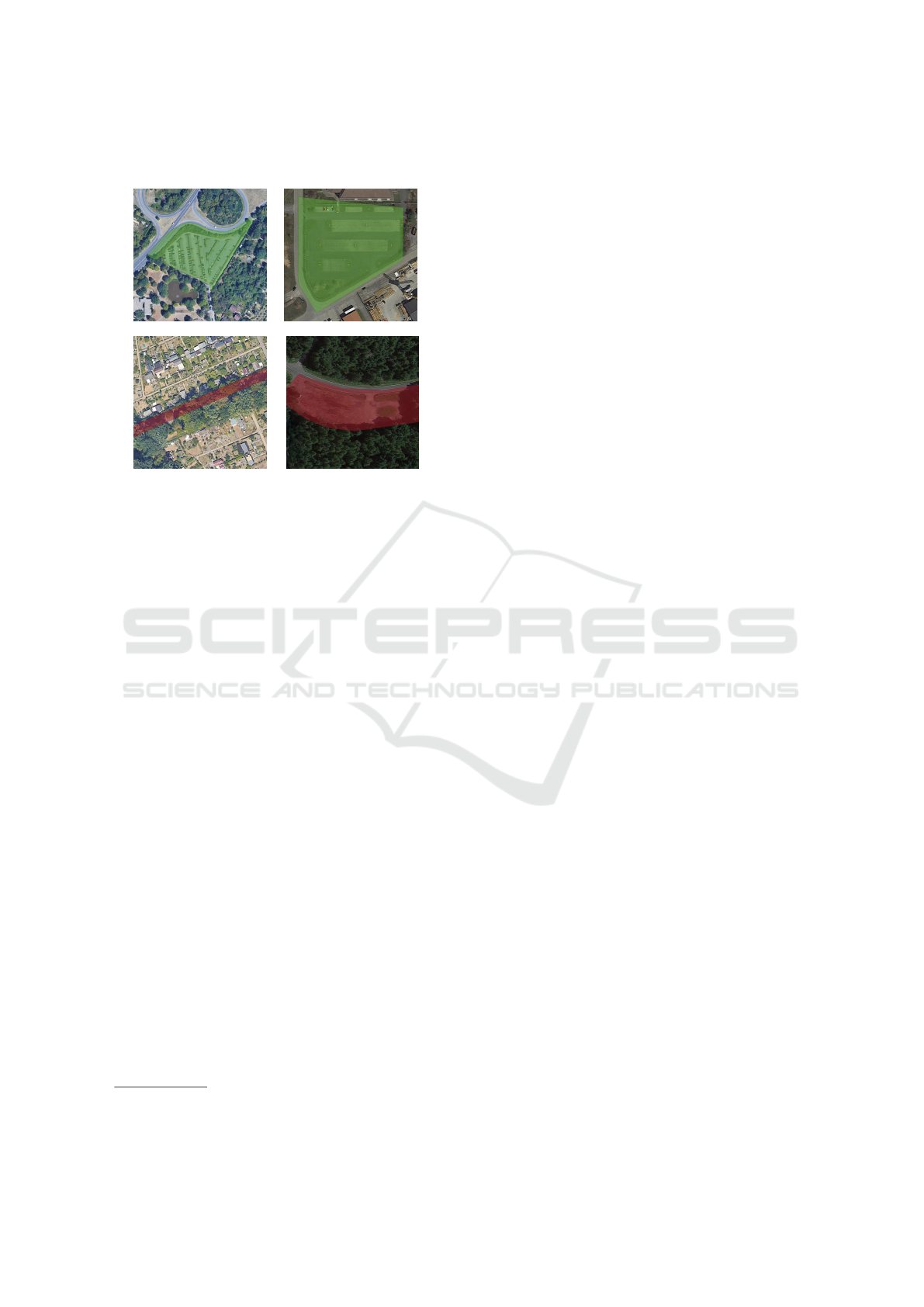
Table 1: Exemplary parking lots manually labeled and clas-
sified as suitable (first row), and unsuitable (second row).
by a north slope >5
◦
or a steep slope >30
◦
(see Sec-
tion 4.1).
Additionally, a raster file at a resolution of
0.2 m × 0.2 m has been generated, providing class
predictions at the pixel level from a deep learning seg-
mentation model.
1
Based on these results, we can
calculate ratios within the parking lots and surround-
ing locations and extract information about the sur-
face texture. In total, the land cover layer consists
of eleven classes, such as fully sealed, partially
sealed, tall vegetation, or low vegetation. A
raster dataset of NDVI with a spatial resolution of
10 m × 10 m is employed to assess vegetation density
and health. NDVI is calculated as the mean during the
summer months between 2018 to 2023. Lastly, we in-
clude the total green volume with a spatial resolution
of 100 m × 100 m calculated with an NDVI threshold
and a normalized digital surface model.
Based on these input data sources, we generated
several input features, as described in Section 4.
3.4 Additional Validation Data
To enhance and validate our proposed approach, we
utilize average annual solar radiation data from 193
selected parking lots within the city district of Frank-
furt am Main (approximately 20 % of Frankfurt’s
parking lot area). These data have been obtained by
manually outlining the polygon shapes of the selected
areas based on high-resolution solar radiation infor-
mation provided by the Hessian solar register (Ger-
man: Solarkataster Hessen) (Landes Energie Agen-
tur Hessen, 2025). This online tool is designed to as-
1
This deep learning segmentation model was a result of
the extended research within the project.
sess the suitability of rooftops and open spaces for PV
installations, considering factors such as solar radia-
tion, shading, and orientation (Landes Energie Agen-
tur Hessen, 2025).
4 METHODS
This section outlines an automated pipeline for
preparing, analyzing, and modeling parking lots to as-
sess the suitability of PV installations.
4.1 Preprocessing
Nine buffer zones are established around 10.894 po-
tential parking lots at distances of 0 m, 1 m, 5 m, 7 m,
10 m, 15 m and 20 m to facilitate the parking lots
themselves (0 m) and their surrounding environment
analysis. These buffers are dissolved with different
input sources such as land cover, NDVI, and green
volume (see Sections 3.3 and 4.3), and intermediate
layers are generated for each buffer distance.
4.2 Splitting in Training and Test
Dataset
Based on the labeled reference data, we split the
dataset using stratified sampling with a ratio of 80 : 20
into a training and test set using scikit-learn (Pe-
dregosa et al., 2011). In addition, we apply a fixed
random seed to ensure reproducibility. The imbalance
of the dataset is the main reason for the stratification.
In pre-testing, we have systematically added labeled
data points from the minority class to the dataset.
This manual extension effectively implements an up-
sampling approach with actual data, addressing the
dataset imbalance (see Section 3.2) (More, 2016).
The test set consists of parking lots the models
have never encountered. It is used exclusively for fi-
nal evaluation and has never been part of the train-
ing phase. As outlined below, the 80 % portion des-
ignated for training is split into three cross-validation
folds for hyperparameter optimization.
Figure 1 shows the distribution of unsuitable and
suitable parking lots in the training and test sets.
4.3 Feature Extraction
Based on different input data sources, we extract ad-
ditional features.
To extract the features, the calculated buffer zones
overlap with the thematic layer NDVI, green volume,
Machine Learning for Identifying Potential Photovoltaic Installations on Parking Areas
247

Figure 1: Class distribution of the training and test set. The
unsuitable parking lots are visualized in red, while the suit-
able parking lots are green. The respective darker colors
represent the test subset.
and land cover information. Therefore, we calcu-
late five key geo-statistics features: minimum, max-
imum, mean, median, and sum for each buffer area
and the NDVI and green volume.
Regarding the high-resolution land cover, we ex-
tract three geostatistical features per buffer zone:
count, area, and proportion for the eleven land cover
classes. The count is given in pixel numbers, while
proportion represents the ratio between the occurring
land cover classes.
With every overlapping and calculation, interme-
diate layers are created and merged into one layer via
spatial join, and new attributes are assigned for each
buffer distance and topic.
In a subsequent feature extraction step, we
compute additional geometry-related features for
each parking lot object. These include bounding
box dimensions, e.g., lengthwidth, elongation,
perimeter, compactness, convexity ratio,
centroid coordinates, and solidity. The
bounding-box area-to-lot area ratio captures the
object’s fit within its bounding box, while the shape
area and perimeter are updated accordingly. Fur-
thermore, three additional class ratio features are
generated, relating sealed (fully or partially sealed)
pixel counts to vegetation counts (low, medium, or
tall).
Finally, all existing NDVI and green volume fea-
tures are normalized by each lot’s area, producing re-
spective variants divided by shape area and further
enhancing the comparability of metrics across differ-
ently sized parking lots.
After applying correlation analysis, we discard
highly correlated features with a correlation coeffi-
cient >95 %, resulting in 70 final input features. Ad-
ditionally, we have tested dimension reduction tech-
niques without considerable impact on the models’
performance.
In the final step, we remove 77 parking lots with
missing values due to district boundaries exceeding
limits. We then combine the input features with the
suitability class labels of the reference dataset (1, 002
objects), which contain information about whether
the dataset will be used for training or testing. The
remaining 9, 892 parking lots are not labeled and will
be applied in the final model.
Within the Frankfurt city district, we combine the
solar radiation data (see Section 3.4) with the labeled
parking lots to evaluate the model’s predicted suitabil-
ity classes and our manually labeled reference class
later.
4.4 Model Development and
Optimization
Several ML methods exist for supervised learning.
We study selected state-of-the-art shallow learning
ML approaches to solve the classification task: Ran-
dom Forest (Breiman, 2001), XGBoost (Chen and
Guestrin, 2016), Extra Trees (Geurts et al., 2006),
LightGBM (Ke et al., 2017), and CatBoost (Dorogush
et al., 2018). All of the models are tree-based ensem-
ble approaches.
Each model is initialized with baseline configu-
rations (e.g., random state, default parameters) and
evaluated on identical training and test sets to ensure
comparison regarding the results.
As hyperparameter tuning, we rely on the
Bayesian optimization strategy (BayesSearchCV
from scikit-optimize) (Frazier, 2018; Head
et al., 2018). The hyperparameters max depth,
n estimators, learning rate, and class
weighting are tuned within predefined ranges
using three-fold cross-validation. To address class
imbalance, balanced accuracy is used as the primary
optimization metric, ensuring equal consideration of
minority class performance. After identifying each
model’s hyperparameters, the final models are trained
on the entire training dataset and evaluated on the test
set.
Besides, we use SHapley Additive exPlanations
(SHAP) (Lundberg and Lee, 2017) to explain and
clarify the feature importance of the input data.
SHAP measures each feature’s contribution to model
predictions, providing a unified and theoretically
sound approach to interpreting machine learning
models (Lundberg and Lee, 2017).
This analysis improves our understanding of the
features that influence the classification of PV suit-
ability.
GISTAM 2025 - 11th International Conference on Geographical Information Systems Theory, Applications and Management
248
5 RESULTS AND DISCUSSION
The results of the applied ML models are evaluated
based on commonly applied classification metrics.
We rely on Precision, Recall, F1 Score, Log Loss,
Balanced Accuracy (BA), ROC-Auc, and Average
Accuracy (AA). Given the dataset’s imbalance, BA
and F1 scores are prioritized to ensure robust perfor-
mance across all classes. Log Loss also evaluates the
reliability of probability estimates, while ROC-AUC
and Average Precision provide insights into the mod-
els’ discriminative abilities.
Table 2 summarizes the classification results of
the ML models on the test dataset. All ML models
demonstrate strong performance with high Precision,
Recall, and F1 scores.
In particular, the XGBoost model achieves the
highest balanced accuracy with 99 % on the test
dataset, along with exceptional precision, Recall, and
F1 score values. XGBoost exhibits the lowest log loss
with 0.05, indicating excellent calibration and reliable
probability estimates.
The CatBoost and Extra Trees classifiers also per-
form robustly, with balanced accuracy scores of 99 %
and log loss values of 0.05 and 0.06, respectively.
These models maintain high precision and recall, ac-
curately classifying suitable and unsuitable parking
lots.
Although the Random Forest and LightGBM
models show slightly higher log loss values of 0.10
and 0.12, respectively, they still deliver commendable
balanced accuracy scores of 99 %. Their strong per-
formance underscores their effectiveness in handling
class imbalance within the dataset.
Slight Recall and F1 score variations emphasize
nuanced differences in each model’s ability to capture
relevant positive instances while maintaining overall
accuracy (see Table 2).
Due to the consistent classification performance of
the XGBoost classifier in terms of balanced accuracy,
this model is selected for further analysis and classifi-
cation of all parking lots in Hesse. Unlike other mod-
els, XGBoost efficiently handles imbalanced datasets,
reducing bias toward the majority class (suitable park-
ing lots) while maintaining high recall for the minor-
ity class (unsuitable lots). Due to its computational
efficiency and handling of high-dimensional feature
spaces, it is well-suited for large-scale applications,
making it a practical choice for real-world urban en-
ergy planning. By confirming that XGBoost outper-
forms other tree-based ensemble models, we provide
strong empirical justification for its selection as the
optimal classifier for this study.
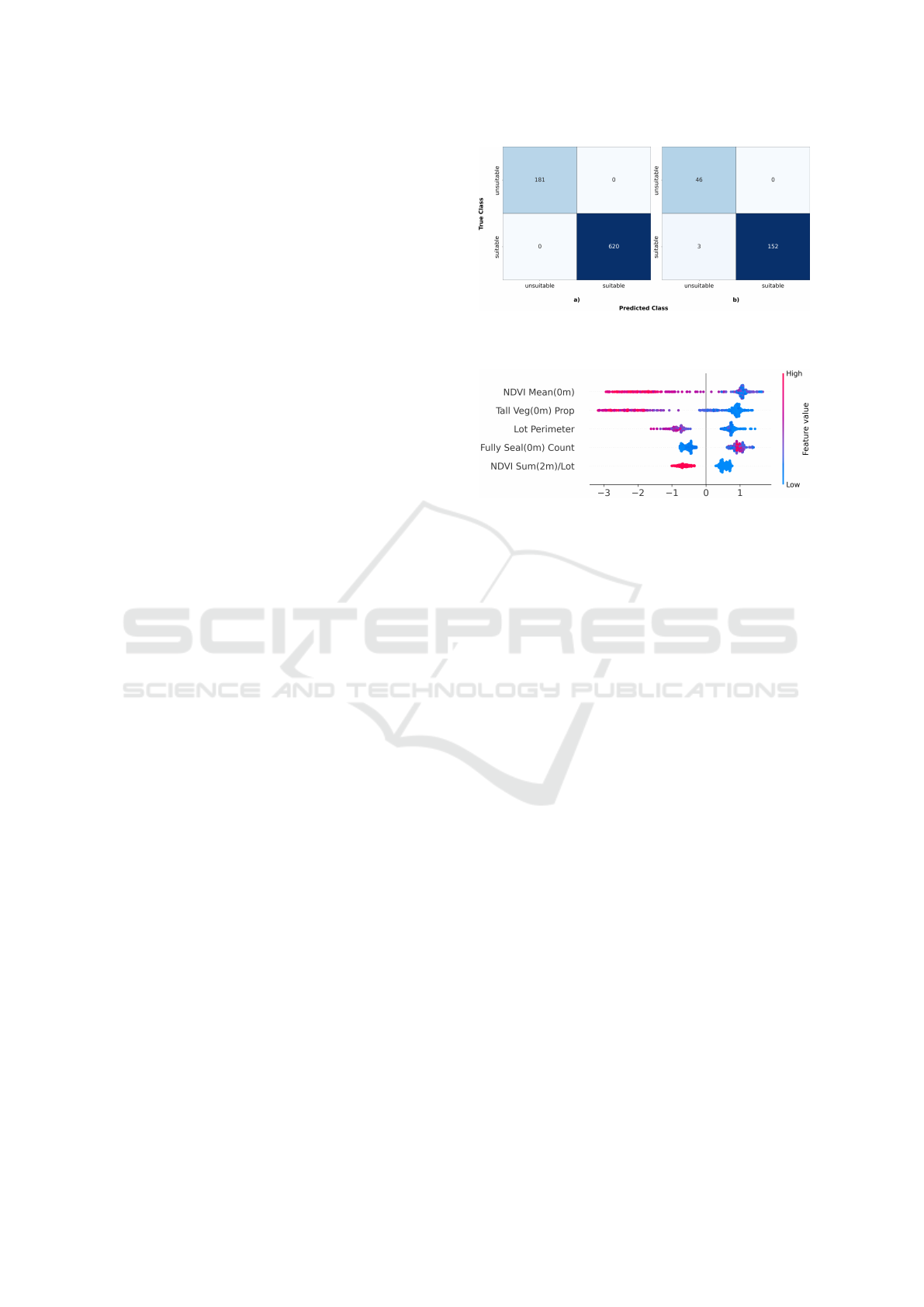
Figure 2 visualizes the classification results of the
Figure 2: Confusion matrix of the XGBoost model on the
(a) training dataset and (b) test dataset.
Figure 3: SHAP plot illustrating the feature importance for
the XGBoost model (five most important features, listed
left) based on the training dataset. Colors indicate feature
values. While high values are red, low values are blue.
XGBoost model of the training and test datasets, re-
spectively. It elucidates the number of correctly and
incorrectly classified areas and the influence of vari-
ous features on the model’s predictions.
Figure 3 illustrates how individual input features
influence the XGBoost model’s classification of park-
ing lots as suitable or unsuitable for PV installations.
Each SHAP value represents the importance of a fea-
ture, with blue indicating low and red indicating high
feature values. The most significant feature is the
NDVI Mean (0m), representing the mean vegetation
index within the 0 m buffer (location of the parking
lots themselves). High NDVI values (red), indicating
dense vegetation, reduce the suitability for PV instal-
lations.
Another essential feature is the proportion of tall
vegetation on the parking lot, where higher pro-
portions (red) also decrease PV suitability. In con-
trast, the fully sealed count indicates that areas
with more sealed surfaces (blue) increase suitability,
as these surfaces are better suited for PV. Additional
features such as the lot perimeter and the NDVI
sum/lot ratio within the 2 m buffer zone show similar
trends, where sealed and less vegetated areas enhance
suitability.
In summary, vegetation-related features nega-
tively impact PV suitability, while sealed surfaces
contribute positively.
Machine Learning for Identifying Potential Photovoltaic Installations on Parking Areas
249
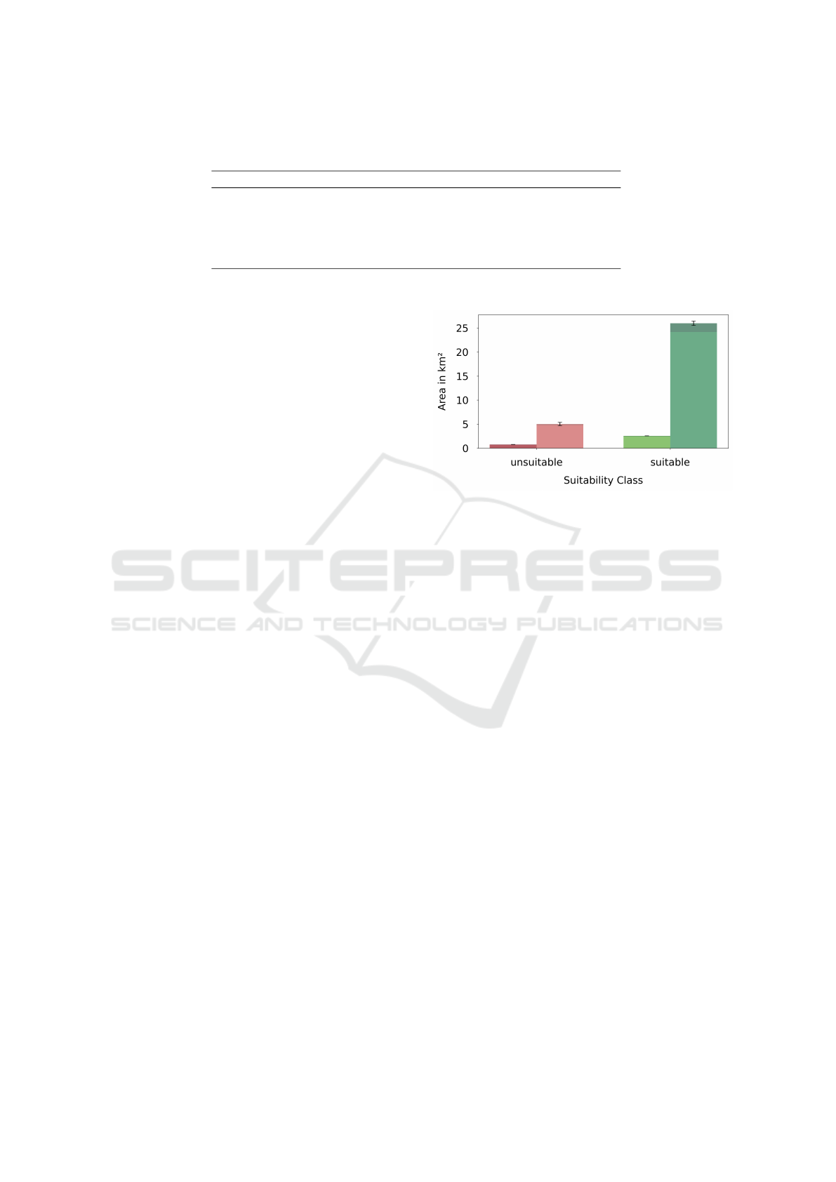
Table 2: Classification results of the applied ML models on the test dataset. BA means Balanced Accuracy. The best-
performing model is highlighted.
ML Model Precision Recall F1 Score Log Loss BA
Random Forest 1.00 0.96 0.98 0.10 0.98
XGBoost 1.00 0.98 0.99 0.05 0.99
Extra Trees 1.00 0.98 0.99 0.06 0.99
LightGBM 1.00 0.98 0.99 0.12 0.99
CatBoost 1.00 0.97 0.99 0.05 0.99
6 APPLICATION OF THE BEST
MODEL
Since we aim to investigate all parking lots within
Hesse, we apply the strong classification model, XG-
Boost, to the entire parking lot data.
6.1 Assessing the Parking Lot Dataset
of the Study Region Suitable for PV
Analysis of Parking Lots Suitable for PV in Hesse:
The parking lot dataset’s overlap with settlement ar-
eas provides insight into the distribution of parking
lots in urban and rural regions. A weighted area is
calculated for each class to quantify classification un-
certainty, shown as black error bars in Figure 4. This
weighted area is derived by multiplying the actual
area of each parking lot by the model’s prediction
probability for that class label. Weighted areas are
summed separately for parking lots within and out-
side settlement areas. Their deviations are used to
compute the standard deviation of the weighted areas.
The total potential amounts to 28.541 km
2
of PV
suitable parking lots, with a model prediction uncer-
tainty of 0.47 km
2
. These parking lots represent ap-
proximately 0.1 % of Hesse’s total area. This analysis
highlights the potential for using parking lots for PV
installations. However, this potential is gradually re-
duced when practical constraints, including technical
feasibility, economic viability, legal considerations,
and environmental impact, are considered.
Identifying the percentage of parking lot areas
suitable for PV systems is essential to accurately and
generally assess the potential of PV parking lot in-
stallations. This area coverage factor, which indicates
the percentage, can vary significantly between stud-
ies, ranging from 18 % to 79.4 %. These differences
are attributed to the varying assumptions and method-
ologies used in the existing investigation (Maier et al.,
2024).
Of the 28.541 km
2
classified as suitable,
1.606 km
2
are identified as existing rooftops.
Although rooftops are also suitable for PV, they are
Figure 4: Distribution of parking lots in urban and rural
areas on the reference dataset (dark red and green) and the
entire dataset of Hesse (light red and green), classified using
the XGBoost model. Shaded areas (right) represent parking
lots outside urban areas. The black boxplots represent error
bars, while the estimated area represents the theoretical po-
tential of suitable PV parking lots.
excluded from the analysis. Additionally, 1.637 km
2
of tall vegetation and 0.401 km
2
of medium-sized
vegetation were subtracted, as removal of vegetation
would have a significant environmental impact. Re-
garding these exclusions, the upper range of available
parking lot area for PV is 24.921 km
2
.
To minimize environmental impact, PV installa-
tions should focus on paved surfaces, reducing the
available area to 21.804 km
2
(= 50.8 % of the theo-
retical potential parking lot area). These figures align
with previous upper estimates for parking PV poten-
tial.
By incorporating various spatial and geometric
features as input for the data-driven models, we can
provide explainable information on what the ML ap-
proaches rely on to solve the classification task. This
explainability can be a first step towards more trans-
parency, which is often lacking according to (Maier
et al., 2024), concerning the overall topic of PV on
parking lots.
GISTAM 2025 - 11th International Conference on Geographical Information Systems Theory, Applications and Management
250

6.2 Solar Energy Investigation of
Selected Parking Lots
One key challenge in validating ML models for PV
suitability assessment is the limited availability of
high-resolution solar radiation data. In the case of
Hesse, such data is not freely accessible for the en-
tire region, restricting our ability to perform a com-
prehensive solar energy potential analysis.
To address this challenge, we have conducted a
case study using 193 manually validated parking lots
in Frankfurt am Main, where high-resolution solar
data from the Hessian Solar Register was available.
This targeted validation serves as a representative test
of our model’s effectiveness.
Figure 5 compares solar radiation (kW h m
−2
) for
193 parking lots in Frankfurt am Main, classified as
suitable or unsuitable by the model. A Mann-Whitney
U test confirms that parking lots predicted as suit-
able exhibit significantly higher solar radiation than
those predicted as unsuitable (p<0.001, Cliff’s ∆=
−0.848). Suitable lots show median solar radiation of
950 kW h m
−2
, compared to 702 kWh m
−2
for unsuit-
able lots. These findings demonstrate that the model
effectively identifies locations with higher solar po-
tential despite having no solar radiation as an input.
Further, this result shows that the manual labeling of
selected parking lots as suitable and unsuitable has
been conducted correctly.
While the analysis covers approximately 20 % of
all parking lots in Frankfurt am Main, the results val-
idate the suitability predictions regarding solar radia-
tion. The classification correlates well with expected
solar potential, even though our model does not ex-
plicitly use solar radiation as an input feature.
Integrating this framework with high-resolution
solar radiation datasets and an economic analysis tool,
such as the Hessian solar register, could optimize
yield and return-on-investment analyses for PV de-
ployment across the entire state of Hesse without re-
quiring manual labeling.
These findings demonstrate that our feature-driven
classification approach can effectively predict so-
lar suitability without comprehensive solar radiation
datasets. Future work could integrate solar modeling
techniques or partner with governmental agencies to
obtain broader access to radiation data for full-scale
validation.
Figure 5: Violin plots comparing solar radiation for unsuit-
able (red) and suitable (green) parking lots classified by the
XGBoost model.
7 CONCLUSIONS AND
OUTLOOK
In conclusion, the innovative framework proposed
establishes a solid foundation for assessing the PV
potential in urban parking areas at scale, encourag-
ing new research and applications in renewable en-
ergy and urban development. By integrating di-
verse datasets, such as OSM, ATKIS, and high-
resolution geospatial imagery and utilizing advanced
machine learning techniques, we identified and clas-
sified suitable parking areas for PV canopy installa-
tions. The model’s effectiveness is illustrated through
its application in Hesse, Germany. The XGBoost
model achieved an impressive classification accuracy
of 99 %, distinguishing suitable sites based on fea-
tures like vegetation indices and sealing ratios. About
21.8 km
2
of parking areas were identified as suitable
for PV, promoting sustainable energy solutions.
Validation against solar radiation data further con-
firms the model’s reliability without requiring explicit
radiation inputs. This approach bridges the gap be-
tween theoretical potential and actionable insights,
equipping urban planners and policymakers to opti-
mize energy systems toward climate-neutrality goals.
Its independence from high-resolution radiation mod-
els increases its applicability in data-scarce environ-
ments, and the automated processing enhances scala-
bility.
Future research directions can include:
• Assess Economic Feasibility: Analyzing installa-
tion costs and return-on-investment to help prior-
itize PV deployment sites.
• Integrate Additional Validation Datasets: Collab-
orating with regional agencies for broader solar
data access to evaluate classification performance.
Overall, this study offers a scalable, data-driven
framework for assessing PV potential in urban set-
Machine Learning for Identifying Potential Photovoltaic Installations on Parking Areas
251

tings. This has implications for urban planning, re-
newable energy investments, and policy-making. The
method can be replicated in other regions, validating
its applicability across diverse geographical and cli-
matic contexts.
ACKNOWLEDGEMENTS
We thank the HMWVW for the part-funding of this
work.
REFERENCES
Breiman, L. (2001). Random forests. Machine Learning,
45(1):5–32.
Chen, T. and Guestrin, C. (2016). Xgboost: A scalable
tree boosting system. In Proceedings of the 22nd
ACM SIGKDD International Conference on Knowl-
edge Discovery and Data Mining, pages 785–794.
ACM.
Dorogush, A. V., Ershov, V., and Gulin, A. (2018). Cat-
boost: Gradient boosting with categorical features
support. ArXiv, abs/1810.11363.
Figueiredo, R., Nunes, P., and Brito, M. C. (2017). The
feasibility of solar parking lots for electric vehicles.
Energy, 140:1182–1197.
Frazier, P. I. (2018). A tutorial on bayesian optimization.
arXiv preprint arXiv:1807.02811.
Geurts, P., Ernst, D., and Wehenkel, L. (2006). Extremely
randomized trees. Machine Learning, 63(1):3–42.
Head, T., Pak, M., Louppe, G., Shcherbatyi, I., Char-
ras, F., Vin
´
ıcius, Z., and Fabisch, A. (2018). scikit-
optimize/scikit-optimize.
HMWEVW (2023). Photovoltaikpflicht f
¨
ur Parkpl
¨
atze und
Landesgeb
¨
aude. Press Release.
IPCC (2022). Climate Change 2022: Mitigation of Cli-
mate Change. Contribution of Working Group III to
the Sixth Assessment Report of the IPCC. Cambridge
University Press. https://www.ipcc.ch/report/ar6/wg3/
(accessed on 16 January 2025).
Ivanova, A., Chassin, D., Aguado, J., Crawford, C., and
Djilali, N. (2020). Techno-economic feasibility of a
photovoltaic-equipped plug-in electric vehicle public
parking lot with coordinated charging. IET Energy
Systems Integration, 2(3):261–272.
Ke, G., Meng, Q., Finley, T., Wang, T., Chen, W., Ma, W.,
Ye, Q., and Liu, T.-Y. (2017). Lightgbm: A highly ef-
ficient gradient boosting decision tree. In Advances in
Neural Information Processing Systems, pages 3146–
3154.
Krishnan, R., Haselhuhn, A., and Pearce, J. M. (2017).
Technical solar photovoltaic potential of scaled park-
ing lot canopies: A case study of walmart usa. Journal
on Innovation and Sustainability RISUS, 8(2):104–
125.
Landes Energie Agentur Hessen (2025). Solar Kataster
Hessen: A Tool for Utilizing Solar Energy. Accessed:
2025-01-22.
Ludwig, D., Tegeler, A., Schmedes, D., Tomhave, L.,
Hensel, A., Forster, J., Kleinhans, A., Heinrich, M.,
John, R., and Schill, C. (2024). Potenziale f
¨
ur Photo-
voltaik an Bundesfernstraßen. Technical report, Bun-
desanstalt f
¨
ur Straßenwesen (BASt), Bergisch Glad-
bach, Germany.
Lundberg, S. M. and Lee, S.-I. (2017). A unified approach
to interpreting model predictions. In Proceedings of
the 31st International Conference on Neural Infor-
mation Processing Systems, pages 4768–4777. Curran
Associates Inc.
Maier, R., L
¨
utz, L., Risch, S., Kullmann, F., Weinand, J.,
and Stolten, D. (2024). Potential of floating, parking,
and agri photovoltaics in germany. Renewable and
Sustainable Energy Reviews, 200:114500.
Marneni, N., Agarwal, N., and Munshi, N. (2021). Techno-
economic analysis of solar carports for a commer-
cial building: A u.s. case study. Energy Reports,
7:160–168. https://www.sciencedirect.com/science/
article/pii/S2352484721000686 (accessed on 16 Jan-
uary 2025).
More, A. (2016). Survey of resampling techniques for
improving classification performance in unbalanced
datasets. ArXiv, abs/1608.06048.
Pedregosa, F., Varoquaux, G., Gramfort, A., Michel, V.,
Thirion, B., Grisel, O., Blondel, M., Prettenhofer, P.,
Weiss, R., Dubourg, V., Vanderplas, J., Passos, A.,
Cournapeau, D., Brucher, M., Perrot, M., and Duch-
esnay, E. (2011). scikit-learn: Machine learning in
python. https://scikit-learn.org/. Version 0.24.2.
Santamouris, M. (2020). Recent progress on urban over-
heating and heat island research: A review. Current
Opinion in Environmental Science & Health, 13:89–
97.
Solar Cluster BW (2022). Photovoltaik-Parkpl
¨
atze: So-
lar
¨
uberdachung von Park- und Stellpl
¨
atzen. Tech-
nical report, Solar Cluster Baden-W
¨
urttemberg e.V.,
Stuttgart, Germany. Faktenpapier des Photovoltaik-
Netzwerks Baden-W
¨
urttemberg. Original authors:
Solar Cluster Baden-W
¨
urttemberg e.V., Gerhard
Stryi-Hipp, Thomas Uhland.
Wirth, H. (2023). Aktuelle Fakten zur Photovoltaik in
Deutschland. Technical report, Fraunhofer-Institut f
¨
ur
Solare Energiesysteme ISE. Available at www.pv-
fakten.de, accessed on January 20, 2025.
GISTAM 2025 - 11th International Conference on Geographical Information Systems Theory, Applications and Management
252
