
Evaluation of EnMAP Hyperspectral Data for the Identification of
Placers in the Rias Baixas Region (Spain)
Beatriz L. Araújo
1a
, Joana Cardoso-Fernandes
1,2 b
, Antonio Azzalini
1c
, Morgana Carvalho
1,2 d
,
Alexandre Lima
1,2 e
, Francisco J. González
3f
and Ana Cláudia Teodoro
1,2 g
1
Department of Geosciences, Environmental and Spatial Planning, Faculty of Sciences of the University of Porto,
Rua do Campo Alegre s/n, Porto, Portugal
2
ICT (Institute of Earth Sciences) – Porto Pole, Portugal
3
Marine Geology Resources and Extreme Environments, Geological Survey of Spain (IGME-CSIC), Madrid, Spain
Keywords: Vigo, CRMs, Heavy-Mineral, Placers, EnMAP, Band Ratios, Spectral Unmixing, MTMF, Remote Sensing.
Abstract: Critical Raw Materials are crucial to achieve the European Union’s (EU) goals of a climate-neutral economy
by 2050. The high supply risk led the EU to prioritise domestic mineral exploration. This study, part of the
S34I – SECURE AND SUSTAINABLE SUPPLY OF RAW MATERIALS project, utilised remote-sensing-
based methods to identify and map heavy-mineral (HM) placer deposits in the Ria de Vigo, located in Galicia,
Spain. Documented since the 70s, the sands of the Vigo beaches contain placers rich in Ti, Sn, Li, Rare Earth
Elements (REE), Au, Fe and Cu. Mineral mapping was performed using hyperspectral EnMAP data. Band
ratios were applied to identify possible mineralisation areas. Additionally, spectral unmixing was performed
through the Mixture Tuned Matched Filtering (MTMF) workflow, included in ENVI 6.0 software, and two
classification maps were obtained: one utilising the USGS spectral library and the other employing an HM
concentrate spectral library. Band ratios were able to distinguish possible areas of hydrothermal alteration.
MTMF classifications mapped most HM known to occur in the Ria, namely sillimanite, garnet, tourmaline,
ilmenite, rutile, and monazite, were identified. This first approach will allow the selection of areas of interest
for field validation and verification. The results will also be confronted with existing geological data.
1 INTRODUCTION
Critical Raw Materials (CRMs) are vital in key
industries, such as renewable energy, electronics,
defence and space exploration (Hool et al., 2023).
These materials are crucial for achieving the
European Union (EU) goals of a climate-neutral
economy by 2050 and supporting the green and
digital transition (European Commission et al., 2023)
The S34I – Secure and Sustainable Supply of Raw
Materials for EU Industry project, funded by the
European Union under grant agreement no.
a
https://orcid.org/0000-0002-5734-6155
b
https://orcid.org/0000-0001-8265-3897
c
https://orcid.org/0000-0003-1058-5463
d
https://orcid.org/0000-0001-9920-0886
e
https://orcid.org/0000-0002-6598-5934
f
https://orcid.org/0000-0002-6311-1950
g
https://orcid.org/0000-0002-8043-6431
101091616 (https://doi.org/10.3030/101091616),
addresses these European needs through the
development of data-driven methods to analyse Earth
Observation (EO) data to support mineral exploration
and monitoring of the complete mining cycle in its
exploration, closure and post-closure phases. This
project aims to enhance EU autonomy regarding
CRMs, support the green transition, as well as address
environmental challenges within the mining cycle.
To contribute to those goals, this work applied
remote sensing techniques and hyperspectral data to
identify Heavy Mineral (HM) beach placer deposits
Araújo, B. L., Cardoso-Fernandes, J., Azzalini, A., Carvalho, M., Lima, A., González, F. J. and Teodoro, A. C.
Evaluation of EnMAP Hyperspectral Data for the Identification of Placers in the Rias Baixas Region (Spain).
DOI: 10.5220/0013496200003935
Paper published under CC license (CC BY-NC-ND 4.0)
In Proceedings of the 11th International Conference on Geographical Information Systems Theory, Applications and Management (GISTAM 2025), pages 297-304
ISBN: 978-989-758-741-2; ISSN: 2184-500X
Proceedings Copyright © 2025 by SCITEPRESS – Science and Technology Publications, Lda.
297
in the Ria de Vigo, located in the Rias Baixas region,
Spain. These HM placer deposits, known to occur in
this region since the 70s (IGME, 1976), are rich in Ti,
Sn, Li, Rare Earth Elements (REE), Au, Fe and Cu –
some of which are classified as CRMs by the
European Commission.
Several studies concerning the identification and
characterisation of HM placer deposits using remote
sensing have been carried out using multiple
approaches.
Chandrasekar et al. (2011) used Landsat 7
Enhanced Thematic Mapper Plus data and the
Environment for Visualising Images (ENVI)
software to successfully map minerals like garnet,
zircon and monazite along India’s South Tamil Nadu
coast. Gazi et al. (2019) similarly used Landsat 8,
ENVI, ArcGIS and Erdas Imagine software to
identify and determine the concentration of HM
placer deposits on the Cox Bazar beaches. Rejith et
al. (2020) utilised ASTER and Landsat 8 data to map
beach sediments on the coast of Thiruvananthapuram,
India, by applying the Spectral Angle Mapper
algorithm (SAM). Later, Rejith et al. (2022) also
mapped and studied the beach placers on the east
coast of Nadu, India, using EO-1 Hyperion data and
employing SAM image classification and Random
Forest regression.
In this study, we made a first approach to the use
of hyperspectral Environmental Mapping and
Analysis Program (EnMAP) data used for mineral
mapping to evaluate the potential of such data for
placer exploration.
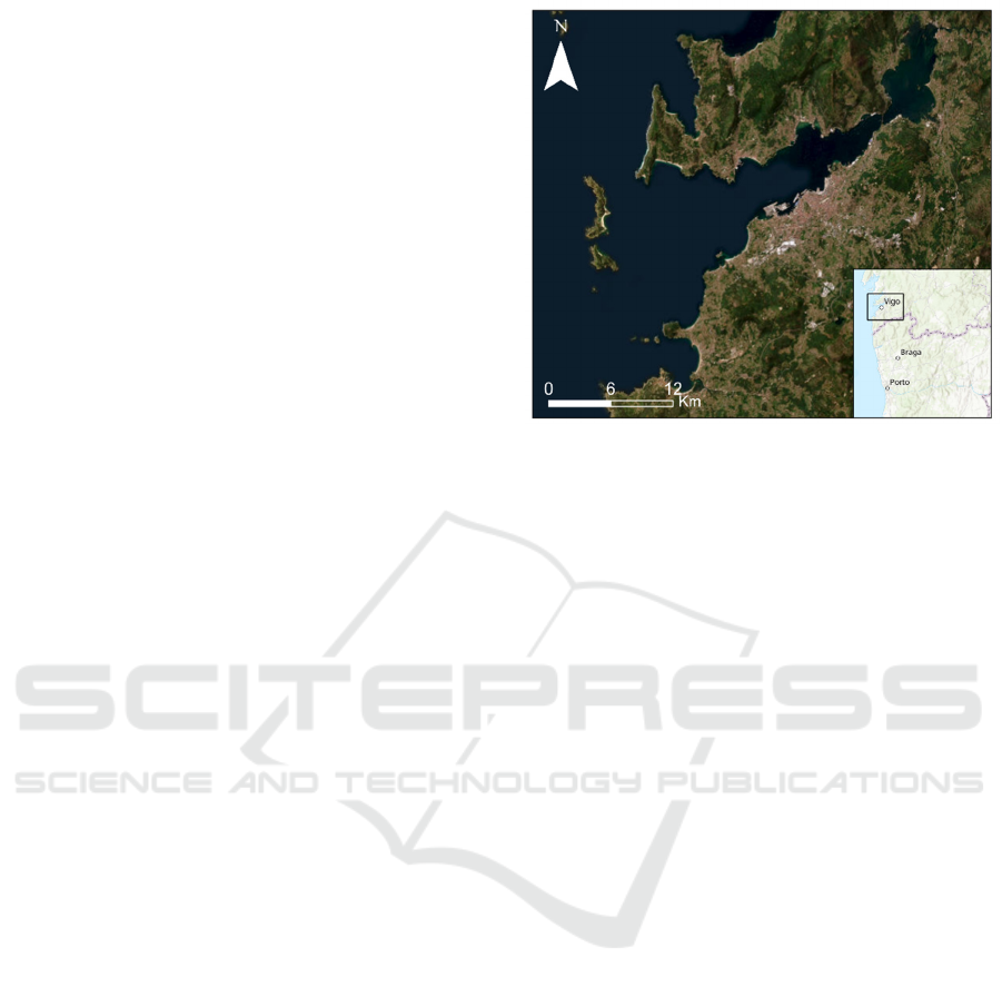
2 STUDY AREA
The Rias Baixas region is located on the Atlantic
margin of southwestern Galicia, in north-western
Spain, close to the border with Portugal (Fig. 1). It is
composed of four morphologically identical
estuaries, known as Rias, of which the Ria de Vigo,
the target of this study, is the southernmost.
The Ria de Vigo is 32.5 km long, measuring 1 km
in width at its inner part, gradually expanding as it
extends towards the mouth of the Ria, where it
becomes 10 km wide, and therefore exhibiting a
distinctive funnel-shaped morphology, positioned
with a NE-SW direction (Méndez & Vilas, 2005).
The geology of this region, which is a part of the
Galicia Trás-os-Montes zone of the Iberian Massif,
consists mainly of metasedimentary sequences,
amphibolites, gneisses and Variscan granitoids
(Capdevila & Floor, 1970; Julivert et al., 1974;
Navas & Corretgé,
1997) (Fig. 2). The geological,
Figure 1: Geographical location of the Ria de Vigo in
Galicia, Spain.
geomorphological and hydrodynamic characteristics
of the Galician beaches allow for concentration of
economically valuable HM, such as magnetite,
ilmenite, garnet, zircon, cassiterite, monazite and
spodumene, forming placer deposits in the land-sea
transition and shallow waters (Galván, 2002; Gent et
al., 2005; IGME, 1976; Méndez et al., 2000; Pérez et
al., 2008; Prego et al., 2009).
The HM sands form elongated layers aligned
parallel to the coastline and are present in Límens,
Santa Marta, Alemáns, Canabal, Ratas, Patos and Vao
beaches. These placer deposits vary seasonally due to
changes in the hydrographic conditions of the Ria. In
late summer and early autumn, HM accumulation is
higher in the Ria’s northern margin, while in late
winter and early spring, it is higher in the southern
margin (Ng-Cutipa et al., 2024).
3 DATA AND METHODS
3.1 Data
For mineral mapping, EnMAP data was employed.
The EnMAP image, a Level-2A product consisting of
224 spectral bands (out of the original 246), was
acquired on 26 June 2024 with a small cloud cover
(<10%). EnMAP data can be accessed by submission
of an acquisition request through the EnMAP
Instrument Planning portal
(https://planning.enmap.org).
It is equipped with a passive push-broom type
hyperspectral imager (HSI) that records reflected
radiation
between 420 nm to 2450 nm in 246 bands,
S34I 2025 - Special Session on S34I - From the Sky to the Soil
298
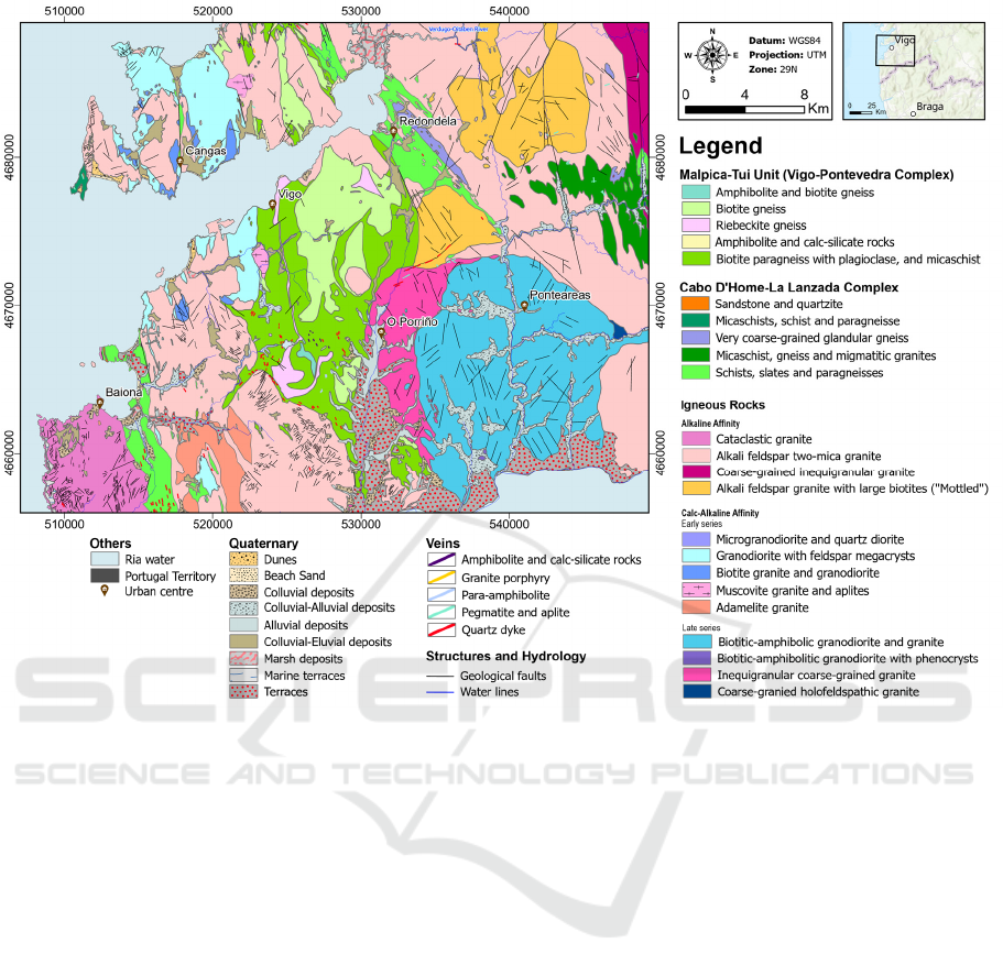
Figure 2: Geological map of the study area, based on the MAGNA 50 – Geological map of Spain, at scale 1:50000.
covering the Visible-Near Infrared (NIR) and the
Short-Wave Infrared (SWIR) range of the
electromagnetic spectrum (Storch et al., 2023). The
spectral resolution is 6.5 nm in the VNIR range and
10 nm in the SWIR, while the spatial resolution is 30
m, providing a swath width of 30 km (Guanter et al.,
2016).
3.2 Processing
EnMAP was processed using two platforms: the
Sentinel Application Platform (SNAP) and the
Environment for Visualising Images (ENVI) 6.0.
EnMAP’s L2A products are considered analysis-
ready, so no further processing is needed except for
spectral subsetting to remove bad-quality bands,
which are corrupted data layers containing no data
pixels (Alicandro et al., 2022). In this case, bands
number 131 (1342.82 nm), 132 (1354.76 nm), 133
(1366.69 nm), 134 (1378.60 nm) and 135 (1390.48
nm) were manually identified and removed. As a
result, the final product consists of 219 bands out of
the original 224.
3.2.1 Band Ratios
For mineral mapping, band ratios were performed in
the first instance to detect zones of alteration and
possible mineralisation.
Different band ratios were tested in this work to
highlight areas of possible hydrothermal alteration,
mainly several ratios for clay minerals, iron oxides
and silicates, as well as carbonates. Hydrothermal
alteration zones in coastal zones can indicate potential
source areas for HM (cassiterite, gold, etc).
Henrich et al. (2012) previously defined several
band ratios, which can be consulted at
https://www.indexdatabase.de/. These ratios are
described in Table 1.
3.2.2 Spectral unmixing
The Mixture Tuned Matched Filtering (MTMF)
algorithm was employed to detect specific mineral
signatures within the image through a spectral
unmixing approach. The MTMF supervised
classification is based on partial unmixing since it can
unmix an endmember from an unknown background.
Evaluation of EnMAP Hyperspectral Data for the Identification of Placers in the Rias Baixas Region (Spain)
299

Table 1: Description of the band ratios performed.
Band ratio T
yp
e of mineral feature
d
𝟏𝟓𝟑
𝟏𝟖𝟗
Alteration
(𝟏𝟓𝟑 + 𝟏𝟗𝟔)
𝟏𝟖𝟗
Alunite/Kaolinite/Pyrophyllite
𝟏𝟖𝟗 ∗ 𝟐𝟎𝟒
𝟏𝟗𝟔
𝟐
Clay
𝟐𝟎𝟒
𝟏𝟖𝟗
Kaolinite
(𝟐𝟎𝟒 + 𝟐𝟏𝟕)
𝟐𝟎𝟖
Carbonate/Chlorite/Epidote
(𝟏𝟗𝟔 + 𝟐𝟏𝟕)
(
𝟐𝟎𝟒 + 𝟐𝟎𝟖
)
Epidote/Chlorite/Amphibole
𝟒𝟔
𝟐𝟗
Ferric iron
𝟏𝟖𝟗
𝟔𝟖
+
𝟐𝟗
𝟒𝟓
Ferrous Iron
𝟏𝟓𝟑
𝟔𝟖
Ferric Oxides
𝟏𝟖𝟗
𝟏𝟓𝟑
Ferrous Silicates
𝟏𝟖𝟕 + 𝟏𝟗𝟕
𝟏𝟗𝟒
Al-sheetsilicates
𝟏𝟗𝟔
𝟐𝟎𝟖
Amphibole
𝟏𝟗𝟔 + 𝟐𝟏𝟕
𝟐𝟎𝟖
Amphibole/ MgOH
It uses a Matched Filter (MF) to match the known
spectral signature to the image spectra, maximising
the response of the target spectra and suppressing the
response of unknown elements in the image (Kumar
et al., 2022). The result is a target abundance image
where each pixel has an MF score. The other part of
the classification consists of applying a Mixture
Tuning (MT) method to reduce false positives by
using a linear spectral mixing model to add an
infeasibility image to the results. The results are a set
of rule images that correlate to the MF and
infeasibility scores, for each pixel, when compared to
each endmember spectra. In this work, endmembers
were selected from two different spectral libraries,
one used for each classification attempt (Table 2).
Table 2: Independent spectral libraries used for the MTMF
classification and description of the endmembers.
First
Classification
(USGS library)
Second Classification (HM library)
Spectrum
code
Manual interpretation
Almandine UPO_1
Montmorillonite,
Illite
Goethite UPO_2
Amphibole,
Montmorillonite
Grossular UPO_3
Amphibole,
Montmorillonite
Ilmenite UPO_4
Amphibole,
Montmorillonite
Monazite UPO_5 Chlorite, Biotite
Rutile UPO_6
Montmorillonite,
Illite
Sillimanite UPO_7 Tourmaline, Garnet
Spessartine UPO_8 Tourmaline, Garnet
Tourmaline UPO_9 Tourmaline, Garnet
Zircon UPO_10 Tourmaline, Garnet
The first spectral library was derived from the
USGS spectral library (Kokaly et al., 2017), and the
minerals that constitute the endmembers were
selected due to their known occurrence in the Ria de
Vigo. The second was obtained in the scope of the
S34I project, where HM concentrates of Vigo beach
placer samples were collected in a laboratory, and
their spectral signature was identified with an ASD
FieldSpec4 spectroradiometer. While these HM
concentrates are not spectrally pure, they were used
as endmembers since they represent the mix of
materials found in Vigo beaches.
4 RESULTS
4.1 Band Ratios
The best results were achieved with the Alteration,
Ferric oxides and Amphibole band ratios (Fig. 3). The
alteration band ratio successfully identified areas
known to be affected by metamorphism and,
therefore,
more likely to have significant
S34I 2025 - Special Session on S34I - From the Sky to the Soil
300
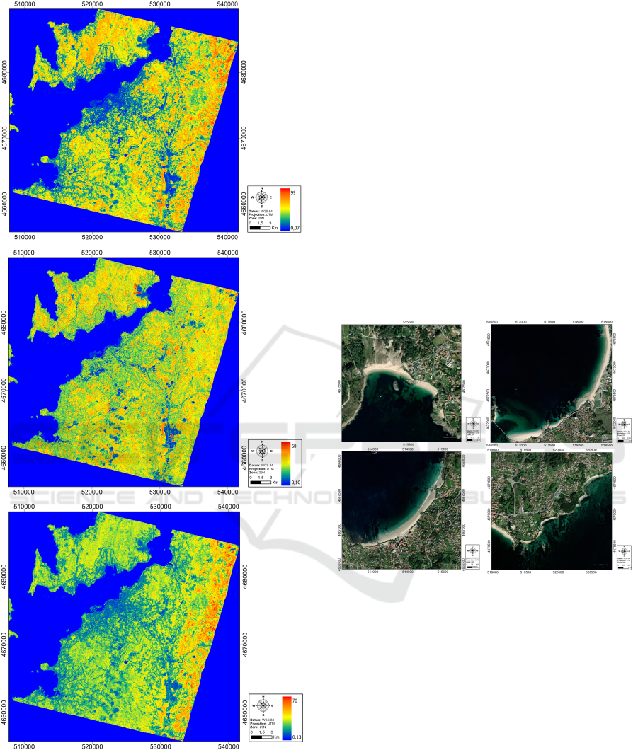
Figure 3: A) Alteration band ratio; B) Ferric oxides band
ratio; C) Amphibole band ratio.
hydrothermal alteration. These areas are
characterised by the vast presence of granitoids,
which, through chemical weathering, lead to the
formation of clay minerals. The ferric oxide ratio
shows a relatively uniform distribution throughout
the image, with a slight increase in ferric oxides
within igneous rock formations. Finally, the
Amphibole band ratio displayed higher values
(corresponding to warmer colours) in areas where
amphibolitic rocks are known to outcrop.
Band ratios were useful for identifying broad
areas of interest despite the limits imposed by the
dense vegetation across the entire EnMAP image
area.
4.2 Spectral Unmixing - MTMF
For both MTMF classifications, two distinct maps
were produced using the Rule Classifier incorporated
in the ENVI software. The maps contain all identified
endmembers, each class represented by a different
colour. The classification maps were performed for
Límens-Santa Marta, Vao-Samil, Patos and Alemáns-
Ratas-Canabal beaches (Fig. 4).
Figure 4: ESRI Basemap imagery for all target Vigo
beaches; A – Límens-Santa Marta beaches; V- Vao-Samil
beaches; C – Patos beach; D – Alemáns-Ratas-Canabal
beaches.
In the first classification, using the USGS spectral
library (Fig. 5), several mineral signatures were
identified across the Vigo beaches, being the main
ones Límens-Santa Marta and Vao. In the Límens-
Santa Marta beaches, signatures from rutile, goethite,
sillimanite, tourmaline, and all three varieties of
garnet, almandine, grossular, and spessartine, were
identified. Spessartine and rutile are mostly present in
dunes. At the Vao beach, sillimanite and grossular
signatures were more dominant. On the Vao and
Samil beaches boundary, ilmenite and tourmaline
were classified on rock outcrops. Iron oxides were
found to be more abundant at Límens-Santa Marta.
A
B
C
A
B
C
D
Evaluation of EnMAP Hyperspectral Data for the Identification of Placers in the Rias Baixas Region (Spain)
301
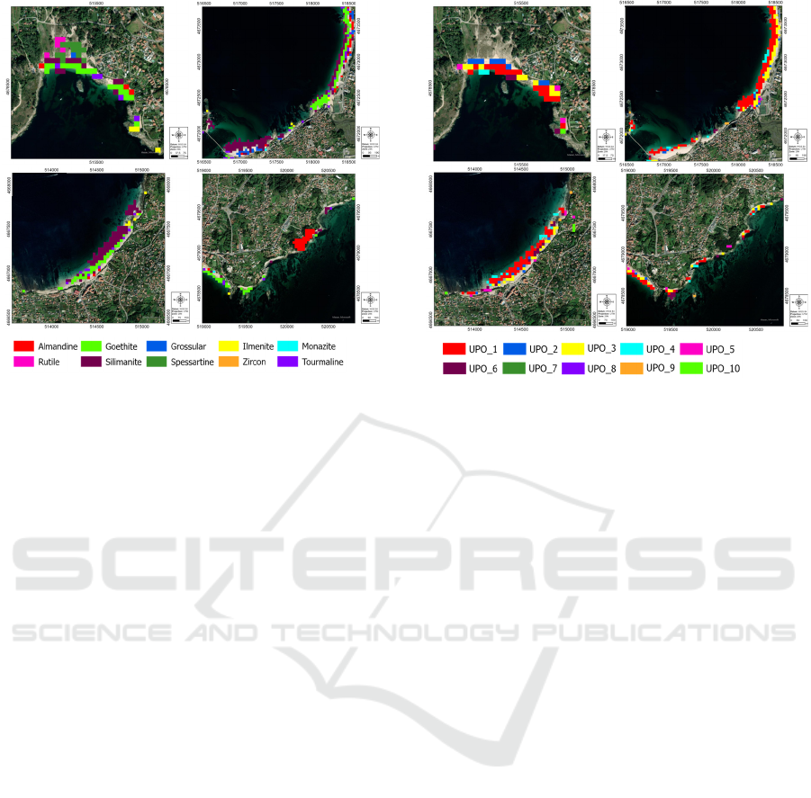
Figure 5: Classification maps derived from the first MTMF
classification using the USGS spectral library and
comparison between Límens-Santa Marta (A1), Vao-Samil
(B1), Patos (C1) and Alémans-Ratas-Canabal (D1)
beaches.
At Patos beach, the goethite signature appears in
higher abundance, especially when compared to Vao
beach. Sillimanite was the most abundant mineral
signature along the stretch that includes Alemáns-
ratas-Canabal beaches.
Using the spectra from HM concentrations for the
second classification (Fig. 6), the most abundant
endmember identified in the Límens-Santa Marta
beaches is UPO_1 (montmorillonite). Other
significant endmembers include UPO_2, UPO_3 and
UPO_4, which are interpreted to be amphibole
(possibly hornblende), with the differential
identification of montmorillonite), as well as UPO_5,
likely corresponding to chlorite/biotite. A smaller
abundance of UPO_6 (montmorillonite) was also
identified.
At the Vao beach, UPO_1 is present but in a much
lower abundance, with it increasing along the
transition northward to the Samil beach. UPO_2 and
UPO_3 are also present, and UPO_9
(tourmaline/garnet) can be observed in rock outcrops.
Patos beach exhibits a high abundance of UPO_1
(montmorillonite/illite), while in Alemáns-Ratas-
Canabal beaches, the same trend continues, with
UPO_1 and UPO_4 (amphibole) being the most
abundant endmembers.
Seasonal variations previously described can be
seen in the MTMF classifications since the highest
abundance of goethite was found in Límens-Santa
Marta beaches in the northern margin.
Figure 6: Classification maps derived from the second
MTMF classification using the HM concentrate spectral
library and comparison between Límens-Santa Marta (A2),
Vao-Samil (B2), Patos (C2) and Alémans-Ratas-Canabal
(D2) beaches.
5 CONCLUSIONS
EnMAP data, due to its high spectral resolution, was
essential to distinguish several HM signatures in the
Vigo beaches. Band ratios are mostly useful for the
detection of potential areas of primary mineralisation,
due to evidence of hydrothermal alteration signatures.
When combined with other datasets, these maps
could help understand the provenance of HM in
placers. Spectral unmixing, included in the MTMF
workflow, identified signatures from most HM
known to be present in the Vigo beaches, except
zircon. Límens-Santa Marta and Vao beaches have
the highest abundance of HM, being the signature of
sillimanite the most identified, although likely to be
overrepresented. Garnets (almandine, grossular and
spessartine), tourmaline, ilmenite signatures were
also identified. Goethite signature is more abundant
in Límens-Santa Marta beach due to seasonal
variations in the Ria’s hydrodynamics. In future
works, exploring fusion methods of EnMAP and
Sentinel-2 data may be of value to enhance EnMAP’s
spatial resolution. Additionally, ground truth data
may be collected to determine MTMF’s accuracy in
classifying and identifying HM in the Vigo beaches.
A1
B1
C1
D1
A2 B2
C2
D2
S34I 2025 - Special Session on S34I - From the Sky to the Soil
302

ACKNOWLEDGEMENTS
This study is funded by the European Union under
grant agreement no. 101091616 (https://doi.org/
10.3030/101091616), project S34I – SECURE AND
SUSTAINABLE SUPPLY OF RAW MATERIALS
FOR EU INDUSTRY. Portuguese National Funds
also support this work through the FCT – Fundação
para a Ciência e a Tecnologia, I.P. (Portugal), projects
UIDB/04683/2020 (https://doi.org/ 10.54499/UIDB/
04683/2020) and UIDP/04683/2020 (https://doi.org/
10.54499/UIDP/ 04683/2020).
REFERENCES
Alicandro, M., Candigliota, E., Dominici, D., Immordino,
F., Masin, F., Pascucci, N., Quaresima, R., & Zollini, S.
(2022). Hyperspectral PRISMA and Sentinel-2
Preliminary Assessment Comparison in Alba Fucens
and Sinuessa Archaeological Sites (Italy). Land, 11,
2070. https://doi.org/10.3390/land11112070
Capdevila, R., & Floor, P. (1970). Les différents types de
granites hercyniens et leur distribution dans le nord
ouest de l'Espagne. Boletin Geol6gico y Minero. T.
LXXXI.-II-III Ano, 215, 225.
Chandrasekar, N., Mujabar, P. S., & Rajamanickam, G. V.
(2011). Investigation of heavy-mineral deposits using
multispectral satellite data. International Journal of
Remote Sensing, 32(23), 8641-8655. https://doi.org/
10.1080/01431161.2010.545448
European Commission, Directorate-General for Internal
Market, I., Entrepreneurship, SMEs, Grohol, M., &
Veeh, C. (2023). Study on the critical raw materials for
the EU 2023 – Final report. Publications Office of the
European Union. https://data.europa.eu/doi/
10.2873/725585
Galván, F. M. (2002). Exploración de placeres costeros de
minerales pesados y su génesis en la costa de galicia.
Gazi, M., Tafhim, K., Ahmed, M. K., & Islam, M. A.
(2019). Investigation of heavy-mineral deposits using
multispectral satellite imagery in the eastern coastal
margin of Bangladesh. Earth Science Malaysia, 3, 16-
22. https://doi.org/10.26480/esmy.02.2019.16.22
Gent, M., Alvarez, M., García Iglesias, J., & Álvarez, J.
(2005). Offshore Occurrences of Heavy-Mineral
Placers, Northwest Galicia, Spain. Marine
Georesources & Geotechnology - MAR GEORESOUR
GEOTECHNOL, 23, 39-59. https://doi.org/10.1080/
10641190590959939
Guanter, L., Kaufmann, H., Förster, S., Brosinsky, A.,
Wulf, H., Bochow, M., Boesche, N. K., Brell, M.,
Buddenbaum, H., Chabrillat, S., Hank, T. B., Heiden,
U., Hill, J., Heim, B., Heldens, W., Hollstein, A.,
Hostert, P., Krasemann, H., Leitão, P. J., . . . Oppelt, N.
(2016). EnMAP Science Plan.
Henrich, V., Krauss, G., Götze, C., & Sandow, C. (2012).
IDB - www.indexdatabase.de, Entwicklung einer
Datenbank für Fernerkundungsindizes. In A.
Fernerkundung (Ed.). Bochum.
Hool, A., Helbig, C., & Wierink, G. (2023). Challenges and
opportunities of the European Critical Raw Materials
Act. Mineral Economics.
IGME. (1976). Investigación minera preliminar de la
plataforma continental submarina de la costa gallega. In
Programa sectorial de Estudio de Fondos Marinos
(FOMAR). Ministerio de Industria.
Julivert, M., Fontboté, J. M., Conde, L., Aldaya, F.,
Capdevila, R., Delgado Quesada, M., Marcos, A.,
Rosell, J., Soler, M., Den Tex, E., Tamain, G.,
Mointinho de Almeida, F., Zbyszewski, G., Manupella,
G., & Carvalhosa, A. (1974). Mapa tectónico de la
península Ibérica y Baleares a escala 1:1.000.000 y
memoria explicativa. Instituto Geologico y Mineiro de
España.
Kokaly, R. F., Clark, R. N., Swayze, G. A., Livo, K. E.,
Hoefen, T. M., Pearson, N. C., Wise, R. A., Benzel, W.
M., Lowers, H. A., Driscoll, R. L., & Klein, A. J.
(2017). USGS Spectral Library Version 7.
Kumar, V., Pandey, K., Panda, C., Tiwari, V., & Agarwal,
S. (2022). Assessment of Different Spectral Unmixing
Techniques on Space Borne Hyperspectral Imagery.
Remote Sensing in Earth Systems Sciences, 5.
https://doi.org/10.1007/s41976-022-00071-8
Méndez, G., Rey García, D., Bernabeu Tello, A. M., Manso
Galván, F., & Vilas Martín, F. (2000). Recursos
minerales marinos en las rías gallegas y en la
plataforma continental adyacente. Journal of iberian
geology: an international publication of earth sciences,
26, 67-98. https://portalcientifico.uvigo.gal/
documentos/5f92241529995257a670d7a0
Méndez, G., & Vilas, F. (2005). Geological antecedents of
the Rias Baixas (Galicia, northwest Iberian Peninsula).
Journal of Marine Systems, 54(1), 195-207.
https://doi.org/https://doi.org/10.1016/j.jmarsys.2004.0
7.012
Navas, J. R., & Corretgé, L. (1997). Hoja 223 (Vigo) -
Mapa Geológico de España, Escala 1:50.000. Madrid,
Instituto Geológico y Minero de España.
Ng-Cutipa, W. L., Lobato, A., González, F., Georgalas, G.,
Zananiri, I., Cardoso-Fernandes, J., Carvalho, M.,
Azzalini, A., Araújo, B. L., & Teodoro, A. C. (2024).
Airborne images integration for a first cartographic
approximation of critical raw-materials-rich placers on
Santa Marta Beach (Ría de Vigo, NW Spain) (Vol.
13197). SPIE. https://doi.org/10.1117/12.3031637
Pérez, I. P., Bernabéu, A. M. G., Rey, D., & Vilas, F.
(2008). Formación del placer de la playa de Montalvo
(Pontevedra).
Prego, R., Caetano, M., Vale, C., & Marmolejo-Rodríguez,
J. (2009). Rare earth elements in sediments of the Vigo
Ria, NW Iberian Peninsula. Continental Shelf
Research, 29, 896-902. https://doi.org/10.1016/
j.csr.2009.01.009
Rejith, R. G., Sundararajan, M., Lakshmanan, G., &
Loveson, V. (2020). Satellite-based spectral mapping
(ASTER and landsat data) of mineralogical signatures
of beach sediments: a precursor insight. Geocarto
Evaluation of EnMAP Hyperspectral Data for the Identification of Placers in the Rias Baixas Region (Spain)
303

International, 37, 1-24. https://doi.org/10.1080/
10106049.2020.1750061
Rejith, R. G., Sundararajan, M., Lakshmanan, G.,
Seenipandian, & Chandrasekar, N. (2022). Exploring
beach placer minerals in the east coast of Tamil Nadu,
India, using EO-1 Hyperion data. Journal of Applied
Remote Sensing, 16. https://doi.org/10.1117/
1.JRS.16.012017
Storch, T., Honold, H.-P., Chabrillat, S., Habermeyer, M.,
Tucker, P., Brell, M., Ohndorf, A., Wirth, K., Betz, M.,
Kuchler, M., Mühle, H., Carmona, E., Baur, S., Mücke,
M., Löw, S., Schulze, D., Zimmermann, S., Lenzen, C.,
Wiesner, S., . . . Fischer, S. (2023). The EnMAP
imaging spectroscopy mission towards operations.
Remote Sensing of Environment, 294, 113632.
https://doi.org/https://doi.org/10.1016/j.rse.2023.1136
32
S34I 2025 - Special Session on S34I - From the Sky to the Soil
304
