
Exploring and Mapping Marine Placers in Vigo Estuary Shoreline
Using GIS Cartographic Tools
Wai L. Ng-Cutipa
1,4 a
, Ana Lobato
1b
, Francisco J. González
1c
, Georgios P. Georgalas
2d
,
Irene Zananiri
2e
, Joana Cardoso-Fernandes
3f
and Ana C. Teodoro
3g
1
Geological Survey of Spain (IGME-CSIC), Rios Rosas 28, Madrid, Spain
2
Hellenic Survey of Geology & Mineral Exploration (HSGME), Spirou Loui 1, Athens, Greece
3
Institute of Earth Sciences, Faculty of Sciences, University of Porto, Rua Campo Alegre s/n, Porto, Portugal
4
Facultad de Ciencias Geológicas, Universidad Complutense de Madrid, José Antonio Novais 12, Madrid, Spain
Keywords: Marine Placer, Integration, GIS, Heavy Minerals, Cartography.
Abstract: Marine placer deposits are accumulations of heavy minerals in coastal areas, both on beaches and in shallow
water, usually consisting of ilmenite, rutile and zircon, and less commonly rare earth minerals (REEs) such
as monazite and xenotime. This study investigates marine placer deposits in the Vigo Estuary (NW Spain),
focusing on integrating diverse on and offshore cartographic data (geology, mineral resources, drainage,
bathymetry, tides, Earth observation and others) for exploration. Six hundred two information points of
marine placers have been analysed, 379 of them from shallow water, where Thiessen polygons have been
spatially calculated. Our results, integrating regional cartographies in a Geographic Information System (GIS),
shown great potential of placer minerals on the Santa Marta and Vao beaches (with presence of garnet,
ilmenite, zircon, monazite and, locally, xenotime). This work 1) highlights the importance of collecting and
analysing different previous information for marine placer exploration in integrated digital cartographies, 2)
allows to program new activities to investigate local areas, 3) remark the remote sensing applications (cheap,
easy and non-invasive tool), better applied to inaccessible areas, and 4) contribute to allow a sustainable
resource exploration and coastal management.
1 INTRODUCTION
Marine placer deposits are accumulations of heavy
minerals found on beaches and shallow water near the
coast (Rona, 2008; Van Gosen et al., 2014; Hou et al.,
2017). Some minerals of economic interest include
ilmenite and rutile (Ti), zircon (Zr), cassiterite (Sn),
monazite and xenotime (Rare Earth Elements- REE),
gold (Au), diamonds, and gems, which accumulate
due to their higher density compared to other
minerals. These deposits are distributed globally on
most coasts (Rona, 2008). In particular, marine placer
a
https://orcid.org/0000-0003-2431-0604
b
https://orcid.org/0000-0002-8620-6506
c
https://orcid.org/0000-0002-6311-1950
d
https://orcid.org/0009-0003-1180-2519
e
https://orcid.org/0000-0002-3440-4316
f
https://orcid.org/0000-0001-8265-3897
g
https://orcid.org/0000-0002-8043-6431
deposits with REE content are located on the coasts
of South Carolina and Florida (USA), Australia,
Brazil, India, Sri Lanka, China, Thailand and
Malaysia (Segupta and Van Gosen, 2016).
Marine placers contain several critical raw
materials (CRMs) that can contribute to the supply of
the European Union (EU) (Grohol and Veeh, 2023)
and other countries, thereby supporting the ecological
transition. Indeed, the European platforms EMODnet
Geology (https://emodnet.ec.europa.eu/en/geology),
GeoERA-MINDeSEA and EGDI provide an
overview of marine mineral resources in their reports
Ng-Cutipa, W. L., Lobato, A., González, F. J., Georgalas, G. P., Zananiri, I., Cardoso-Fernandes, J. and Teodoro, A. C.
Exploring and Mapping Marine Placers in Vigo Estuary Shoreline Using GIS Cartographic Tools.
DOI: 10.5220/0013496900003935
Paper published under CC license (CC BY-NC-ND 4.0)
In Proceedings of the 11th International Conference on Geographical Information Systems Theory, Applications and Management (GISTAM 2025), pages 339-345
ISBN: 978-989-758-741-2; ISSN: 2184-500X
Proceedings Copyright © 2025 by SCITEPRESS – Science and Technology Publications, Lda.
339
and viewer, including marine placer deposits and
occurrences (Zananiri et al., 2021; González et al.,
2023; GSEU, 2024).
Multiple authors have described these deposits
and proposed their exploration from different
approaches, such as the commodity approach (e.g.,
focused on Ti according to Force (1991)), geological,
geochemical and geophysical techniques (Van Gosen
et al., 2014), and specialized mapping (GIS), aerial
photography and topography, remote sensing
techniques, geological methods, drilling, and 3D
modelling (Hou et al., 2017). Recently, and along
with advances in Earth observation (EO), remote
sensing applications have been initiated for placer
exploration (e.g., Rejith et al., 2020 and 2021;
Cardoso-Fernandes et al., 2023; Ng-Cutipa et al.,
2024). This work proposes a methodology for
integrating land-sea information in a geographic
information system (GIS), aimed at: 1) analysing
existing information layers to select local pilot areas,
and 2) applying field exploration and EO tools
focused on the study of marine placers in NW Spain.
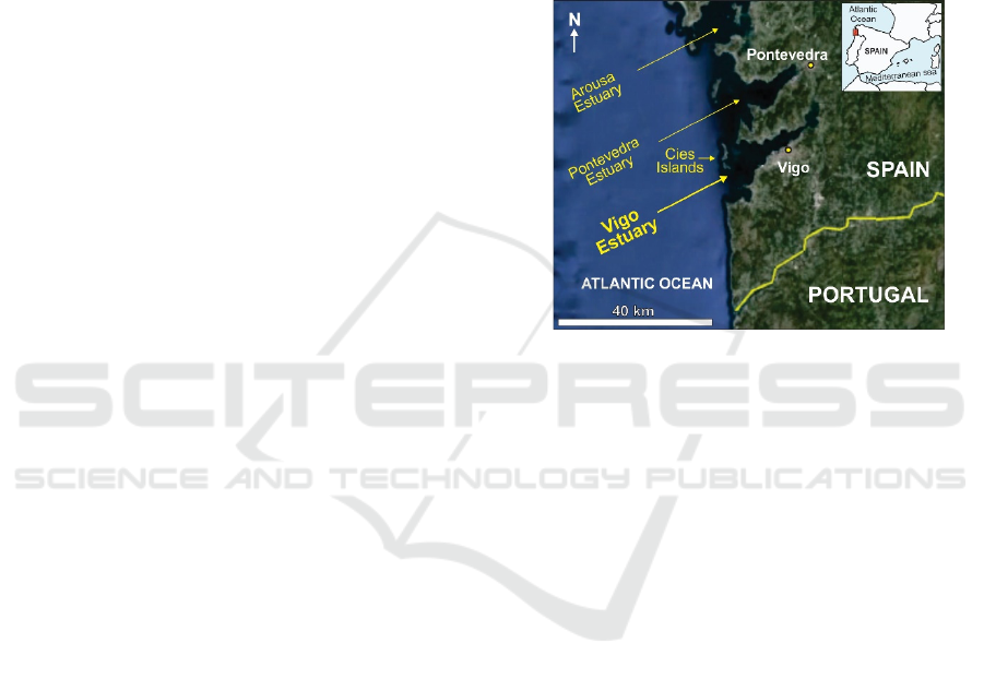
2 REGIONAL SETTING
The Vigo Estuary, one of the Rías Baixas estuaries, is
located in NW Spain. The area's geology comprises
intrusive and metamorphic rocks ranging in age from
the Paleoproterozoic to the Jurassic (González and
Vicente, 2004). The study area is situated within the
MAGNA 50k map sheets of Cíes (0222) and Vigo
(0223), where the estuary is located, with an
approximate NE-SW orientation. In the outer part of
the estuary, the Cíes Islands are located, which are
oriented N-S and act as a natural geographic barrier
that protects the inner area of the estuary (Figure 1).
The main tributary river of the estuary is the Verdugo
River; however, there are numerous smaller tributary
drainages, with those located on each side of the
central axis of the estuary being much shorter.
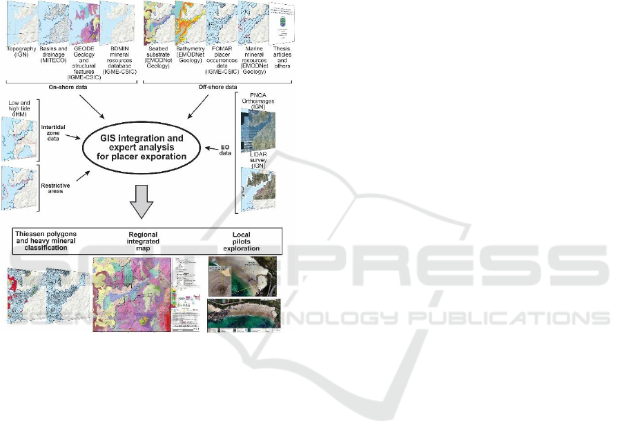
3 DATA AND GIS INTEGRATION
Previous studies have synthesized and grouped
exploration techniques for marine placer deposits
based on geological, geophysical, remote sensing
conditions, etc. (e.g., Van Gosen et al., 2014; Hou et
al., 2017). Within the S34i project, we have focused
on geological information at regional and local scales,
which can contribute to the successful search for
marine placer occurrences in beach and shallow-
water sands. In general, we have grouped the
available data by their geographic environment with
respect to their coverage: on-shore, off-shore and
intertidal zones. To this, we have added a fourth
group, "EO data" (Figure 2), that, depending on the
characteristics of the image, can be used to obtain
information from the three zones described above.
We have also integrated a fifth group called
"restrictive areas", which are areas of natural
protection, economic activities or other
specifications.
Figure 1. Location of Vigo estuary.
3.1 On-Shore Data
The analysed datasets correspond to:
-Topography from the National Geographic
Institute (IGN) of Spain
(https://www.ign.es/web/ign/portal/inicio), which
constitutes the base layer with information on
toponymy and hydrography. The sheets used are 0222
(Cíes) and 0223 (Vigo).
-Basins and drainages from MITECO
(https://www.miteco.gob.es/es/cartografia-y-
sig/ide/descargas/agua.html) at a scale of 1:25,000 (©
Ministerio para la Transición Ecológica y el Reto
Demográfico), which are located within the map
sheets 0222 and 0223.
-Continuous digital geological cartography at a
scale of 1:50,000 (GEODE survey,
https://info.igme.es/cartografiadigital/geologica/geo
de.aspx) from the IGME-CSIC (© CN Instituto
Geológico y Minero de España (IGME), with
geological and structural information of the Z1200
Galicia Tras-Os-Montes area. Around the estuary, a
clear predominance of intrusive and metamorphic
rocks with an approximate N-S orientation is
observed. Quartz dikes can be secondary sources of
heavy minerals of economic interest, such as
tourmaline, cassiterite and gold; however, at a scale
S34I 2025 - Special Session on S34I - From the Sky to the Soil
340
of 1:50,000, they are scarce around the estuary,
according to GEODE.
-Mineral resources database (BDMIN,
http://info.igme.es/catalogo/resource.aspx?portal=1
&catalog=3&ctt=1&lang=spa&dlang=eng&llt=drop
down&master=infoigme&resource=23) from the
IGME-CSIC (© CN Instituto Geológico y Minero de
España (IGME)), is a database that integrates
geological-mining information on evidence, deposits
and exploitation of rocks and minerals in Spain.
Figure 2. Integration methodology for marine placer deposit
exploration in the NW Spain.
3.2 Off-Shore Data
Data related to:
-Bathymetry and seabed substrate data are from
EMODNet Geology
(https://emodnet.ec.europa.eu/en/geology), a
European portal that provides harmonized data. These
allow us to know the morphology and type of seabed.
In the study area, the seabed substrate with Folk 7
classification is available.
-The mineral exploration studies of the
continental shelf of the FOMAR project (IGME, 1976
and 1979) have samples of beach and shallow-water
and semi-quantitative analyses of heavy mineral
contents in Rias Baixas. The most abundant minerals
are generally garnets, ilmenite, zircon and monazite.
-Thiessen polygons were calculated using ArcGIS
from the samples collected on the shallow water in
the FOMAR project, providing an approximate area
of similar heavy mineral content. Ng-Cutipa et al.
(2023) classified the heavy mineral content into five
classes: <1 g, 1-5 g, 5-50 g, >50 g and absence.
-EMODNet-Geology marine resources
(https://emodnet.ec.europa.eu/en/geology) provide us
with marine mineral occurrences in point and polygon
format.
-Other publications, such as these articles and
conferences, include various data related to marine
placer occurrences( Manso, 2001; Ng-Cutipa et al.,
2024).
3.3 Intertidal Zone Data
Low and high tide data from the Hydrographic
Institute (IHM) of Spain provide a regional overview
of the intertidal area, which can influence the surface
occurrence of placer deposits. As mentioned before,
the NW area of Spain has a mesotidal regime, with
variations of 2 to 4 m in height in the intertidal zone.
3.4 EO Data
National Aerial Orthophotography Plan (PNOA) and
Light Detection and Ranging (LiDAR) surveys from
IGN (https://pnoa.ign.es/web/portal/inicio), consist
of orthorectified visible and near-infrared imagery,
and digital elevation information at a very high local
resolution. The PNOA images (PNOA 2020 CC-BY
4.0 ign.es) have a spatial resolution of 15 cm per pixel
in the visible and 25 cm per pixel in the near-infrared.
For geological mapping, the most current images in
the area (year 2020) have been used; the near-infrared
has been used to highlight faults and lineaments (Ng-
Cutipa et al., 2024). The most recent LIDAR flight
(PNOA LiDAR 2020 CC-BY 4.0 ign.es) is from
2015, with a minimum point density of 0.5 - 2
points/m².
Additionally, images were collected through a
UAV survey using a DJI Mini Pro drone for specific
beach research. In March 2024, drone flights were
carried out at 80 and 50 m altitudes, obtaining a
spatial resolution of < 3 cm in the visible range. The
images were taken on the Limens, Santa Marta, Vao,
Fontaiña and Fechiño beaches. EO data provide the
map beach morphology and better identify rock
outcrops, dykes, faults and lineaments, and
delineation of modern placer boundaries.
3.5 Restrictive Areas
This level of information includes the on- and off-
shore areas with access restrictions, areas of local
interest, economic activities, environmental
Exploring and Mapping Marine Placers in Vigo Estuary Shoreline Using GIS Cartographic Tools
341

conservation, and those related to navigation and port
activities of the Vigo Estuary (Figure 2).
4 RESULTS
4.1 Thiessen Polygons and Heavy
Mineral Occurrences
In the Vigo Estuary, 602 information points from the
FOMAR project (223 from the beach and 379 from
the shallow water) have been identified, obtaining
379 Thiessen polygons on the shallow platform,
maintaining the same semi-quantitative values of
heavy mineral concentration (garnet, ilmenite, zircon,
monazite and xenotime; Figure 3).
On the beach, occurrences of garnet of Class 4
(>50 g) are predominant compared to Class 3 (5-50 g,
Figure 3). These are found in the middle-outer part of
the estuary. Ilmenite (brown lines in Figure 3) are
mainly associated with the same points where Class 4
(>50 g) garnets are located, except for the middle part
of the estuary (E of Cangas), where there is an
occurrence of ilmenite and zircon, both of Class 3 (5-
50 g). In addition, zircon with concentrations of Class
4 (>50 g) is only related to Class 4 samples of garnets
and ilmenite on the Santa Marta (W of Cangas) and
Vao-Fuchiños (SW of Vigo) beaches.
Figure 3. Thiessen polygons in shallow water and heavy
mineral content classes 4 and 3.
To a lesser extent, there are also occurrences of
REE minerals, such as monazite and xenotime.
Monazite (green dots in Figure 3) is related to the
Class 4 (>50 g) points described above, with abundant
garnets, ilmenite and zircon (Santa Marta and Vao-
Fuchiños). Monazite is also found to the E of Cangas,
as well as ilmenite and zircon, all Class 3. Xenotime
is only identified with Class 1 (<1 g) in 3 samples
from the same Cesantes Beach, in the inner part of the
estuary (green X in Figure 3). Also, on the beaches
around the Cíes Islands, garnets and ilmenite
predominate.
On the shallow platform, there are no
concentrations of class 4 or 3 in the estuary,
indicating that there are no areas of preferential
concentration in these classes.
4.2 Regional Integrated Map
The geological environment of the Vigo Estuary is
dominated by granites, where outcrops of
orthogneisses, schists and amphibolites mainly
alternate, and to a lesser extent, quartzites and para-
gneisses. On the surrounding seabed, the rocky
substrate and boulders continue from the middle to
the outer part of the estuary, including the Cíes
Islands. The interior of the estuary has a finer
sediment (mud) that changes to mixed mainly. The
other grain size transitions of the seabed appear more
isolated towards the outside of the estuary. The faults
and lineaments on land are generally NW-SE, NNW-
SSE and NE-SW (Figure 4).
Mineral resources onshore are reported as
indications of hematite (Fe, Mn, Ti) and feldspar
(industrial mineral) in the inner part of the estuary
around Redondela. There are several active and, to a
lesser extent, abandoned exploitations of ornamental
rocks (mainly granites). In addition, there are three
zones with minerals hosted in rocks, pegmatites or
dikes and one zone of marine placer occurrences.
These last ones have identified garnets, ilmenite,
zircon, monazite and xenotime, and other heavy
minerals on the beach. As we have seen before in 4.1,
these heavy minerals are less abundant on the shallow
platform.
The areas of human activity and current restrictive
areas have helped us to better plan our field trips and
explore the occurrences of marine placers, previously
identified in the 70s. Some areas of the estuary are no
longer accessible due to the creation of new restricted
areas.
S34I 2025 - Special Session on S34I - From the Sky to the Soil
342
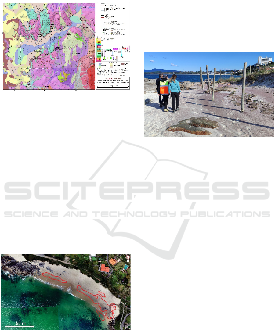
Figure 4. Integrated cartography for placer deposit
exploration in Vigo Estuary, NW Spain.
4.3 Validation: Local Pilots'
Exploration
With the information from 4.2 and the flowchart in
Figure 2, we proceeded to schedule different local
reconnaissance activities to validate the
methodology, starting with an initial visit to confirm
the presence of marine placers on beaches. Upon
finding evidence of heavy minerals, we scheduled
subsequent exploration activities to delve deeper into
the study of marine placers, mainly on the Santa
Marta and Vao beaches. For example, we carried out:
detailed mapping using PNOA and UAV flights (for
outcrops, beach extensions and areas with placers,
Figure 5), identification of faults and dikes (in the
field and with PNOA and UAV images), analysis of
intertidal variation, pits to observe heavy minerals in
depth, ground-penetrating radar exploration, among
others.
Figure 5. Cartography from the UAV survey showing
placer mineral (red polygons) in coastal areas of Santa
Marta Beach (Ng-Cutipa et al., 2024).
The campaigns in different seasons have allowed
to identify the variation of heavy mineral
concentrations and the variation of small streams that
contribute to the supply of these minerals from the
onshore. The important role of tides in the
redistribution and deposition of placers has also been
observed. Likewise, in some areas, such as Vao, wind
action plays an important role in accumulating heavy
minerals at the base of the dune face where the wind
has action (Figure 6).
Figure 6. Accumulation of reddish heavy minerals on the
base of the coastal dune at Vao Beach, Vigo Estuary
(November 2024).
Sand samples have also been taken from different
beaches and shallow water, with and without placers,
to conduct chemical and mineralogical analyses, and
reflectance measurements for their correlation and
use in multi- and hyperspectral images.
5 DISCUSSIONS AND
CONCLUSIONS
Thiessen polygons offer a primary spatial distribution
of occurrence of heavy mineral in shallow-water, that
were perfomed using semiquantitative data. Placer
occurrence on beach show greater accumulation than
shallow-water areas using the same semi-quantitative
data.
Regarding to regional integration map, the
exploration of marine placer deposits, as evidenced
by Van Gosen et al. (2014) and Hou et al. (2017),
highlights the importance of collecting and analysing
different previous information. These depend on the
state of advancement of the region and on the
knowledge desired to acquire about marine placer
deposits. With this, it is possible to propose
complementary studies at the regional level and
others to deepen research at the local level of these
placer occurrences. On the other hand, existing
geological maps at a scale of 1:50,000 offer a great
approximation to select areas of greater interest to
explore these deposits. It is true that, in the case of
Exploring and Mapping Marine Placers in Vigo Estuary Shoreline Using GIS Cartographic Tools
343

NW Spain, the occurrences of marine placers of
FOMAR (IGME, 1976 and 1979) and the occurrences
of heavy minerals previously identified in the
MAGNA project carried out by IGME
(https://info.igme.es/cartografiadigital/geologica/Ma
gna50.aspx) have facilitated the visualization of the
aforementioned areas of interest.
Due to the same difficulty of access and nature of
each area, geological maps and information are more
detailed and updated on-shore than off-shore.
In the local pilots, UAVs offer a high spatial
resolution image where surface placers have been
identified around the shoreline. This survey depends
on the season and the stage of development of the
ephemeral drainages. It is very likely that the large
exposure of surface placers is mainly due to the large
drainage combined with wave and tidal action.
This work highlights the importance of 1)
integrating on- and off-shore information and the
intertidal zone, and 2) knowing the characteristics of
marine placer occurrences in NW Spain, providing
very good results. They have also allowed for the
increase of knowledge of the coastal "white band"
(land-sea transition). Similarly, EO surveys offer a
cheap, easy and non-invasive tool that can be better
applied to inaccessible areas, allowing for sustainable
resource exploration and coastal management.
Finally, in these last 2 years, improvements have been
developed in the knowledge of placers at the local
level that include integrated and improved geological
mapping, new geochemical and mineralogical data of
marine placers, and EO applications and development
of algorithms for images of different satellites
(Sentinel 2, WorldView, EnMap, others).
ACKNOWLEDGEMENTS
This study is funded by the European Union under
grant agreement no. 101091616
(https://doi.org/10.3030/101091616), Project S34I –
SECURE AND SUSTAINABLE SUPPLYOF RAW
MATERIALS FOR EU INDUSTRY.
REFERENCES
Cardoso-Fernandes, J., Carvalho, M., Azzalini, A.,
Rodrigues, G., Monteiro, G., Lima, A., Teodoro, A. C.
(2023). "Sentinel data for critical raw materials (CRM)
exploration: first results of the S34I project", Proc.
SPIE 12734, Earth Resources and Environmental
Remote Sensing/GIS Applications XIV, 127340W (19
October 2023); https://doi.org/10.1117/12.2679373
Force, E. R. (1991). " Placer deposits in shoreline-related
sands of Quaternary age ", Geology of Titanium-
Mineral Deposits, Eric R. Force.
González, F. J., Medialdea, T., Schiellerup, H., Zananiri, I.,
Ferreira, P., Somoza, L., Monteys, X., Alcorn, T.,
Marino, E., Lobato, A. B., Zalba-Balda, Í., Kuhn, T.,
Nyberg, J., Malyuk, B., Magalhães, V., Hein, J. R.,
Cherkashov, G. (2023). "MINDeSEA: exploring
seabed mineral deposits in European seas, metallogeny
and geological potential for strategic and critical raw
materials", The Green Stone Age: Exploration and
Exploitation of Minerals for Green Technologies, M.
Smelror, K. Hanghøj, H. Schiellerup.
https://doi.org/10.1144/SP526-2022-15
González, M. I., Vicente, J. (2004). Mapa Geológico de
España con la inclusión de Portugal continental y
Pirineos franceses E. 1: 2.000. 000. Geología de
España. Madrid: IGME.
Grohol, M., & Veeh, C. (2023). Study on the Critical Raw
Materials for the EU 2023. Publications Office of the
European Union. https://doi.org/10.2873/725585
GSEU. (2024). Critical Raw Materials offshore occurrences
of Europe. Based on the 2023 CRM list of the European
Commission. Map, version 3, scale 1: 50 000 000.
Hou, B., Keeling, J., & Van Gosen, B. S. (2017). Geological
and exploration models of beach placer deposits,
integrated from case-studies of Southern Australia. Ore
Geology Reviews, 80, 437-459. https://doi.org/
10.1016/j.oregeorev.2016.07.016
Manso, F. (2001). Exploración de placeres costeros de
minerales pesados y su génesis en la costa de Galicia.
Doctoral dissertation, Universidad de Vigo, Spain.
Ng-Cutipa, W.; González, J.; Lobato, A.; Zananiri, I.;
Teodoro, A. (2023). Titanium, Zirconium and Rare
Earth Element placer deposits in coastal environments
of Rías Baixas (Galicia, NW Spain). 51st Underwater
Mineral Conference, Róterdam. https://doi.org/
10.5281/zenodo.12566751
Ng-Cutipa, W. L., Lobato, A., González, F. J., Georgalas,
G., Zananiri, I., Cardoso-Fernandes, J., Carvalho, M.,
Azzalini, A., Araújo, B. L., Teodoro, A. C. (2024).
"Airborne images integration for a first cartographic
approximation of critical raw-materials-rich placers on
Santa Marta Beach (Ría de Vigo, NW Spain)", Proc.
SPIE 13197, Earth Resources and Environmental
Remote Sensing/GIS Applications XV, 1319718 (13
November 2024); https://doi.org/10.1117/12.3031637
Ng-Cutipa, W., Lobato, A., González, F. J., Marino, E.,
Rincón-Tomás, B., Santofimia, E., Medialdea, T.,
Somoza, L., Boixereu, E., Piña, R., Lunar, R. (2024).
Investigaciones de placeres marinos ricos en materias
primas críticas en España. Geotemas (Madrid), 20, 730-
733. https://doi.org/10.5281/zenodo.13740607
IGME. (1976). Investigación minera preliminar de la
plataforma continental submarina de la costa gallega.
Programa sectorial de Estudio de Fondos Marinos
(FOMAR). Ministerio de Industria.
IGME. (1979). Investigación minera de detalle en los
fondos submarinos de la zona de las Rías de Pontevedra
S34I 2025 - Special Session on S34I - From the Sky to the Soil
344

y Vigo (GALI-RIAS). Técnicas Especiales de
Geología, A0/027/004, 83 p.
Rejith, R. G., Sundararajan, M., Gnanappazham, L.,
Loveson, V. J. (2022). Satellite-based spectral mapping
(ASTER and landsat data) of mineralogical signatures
of beach sediments: a precursor insight. Geocarto
International, 37(9), 2580-2603. https://doi.org/
10.1080/10106049.2020.1750061
Rejith, R. G., Sundararajan, M., Venkatesan, S.,
Mohammed-Aslam, M. A. (2021). Remote sensing for
exploring heavy mineral deposits: a case study of
Chavara and Manavalakurichi deposits, southwest
coast of India. In Remote Sensing of Ocean and Coastal
Environments, 177-188. https://doi.org/10.1016/B978-
0-12-819604-5.00011-1
Rona, P. A. (2008). The changing vision of marine
minerals, Ore Geology Reviews, Volume 33, Issues 3–
4, 618-666, ISSN 0169-1368, https://doi.org/10.1016/
j.oregeorev.2007.03.006
Segupta, D., Van Gosen, B. S. (2016). "Placer-Type Rare
Earth Element Deposits", Rare Earth and Critical
Elements in Ore Deposits, Philip L. Verplanck, Murray
W. Hitzman. Book Chapter, https://doi.org/10.5382/
Rev.18.04
Van Gosen, B. S., Fey, D. L., Shah, A. K., Verplanck, P. L.,
Hoefen, T. M. (2014). Deposit model for heavy-mineral
sands in coastal environments: U.S. Geological Survey
Scientific Investigations, Report 2010–5070–L, 51 p.,
http://dx.doi.org/10.3133/sir20105070L
Zananiri, I., Zimianitis, V., Georgakopoulos, N., González,
F. J., Marino, E., Somoza, L., Medialdea, T. (2021).
Potential and prospectivity map of placer occurrences
in pan-European Seas. Map, version October 2021,
scale 1: 7 000 000. https://geoera.eu/projects/
mindesea2/
Exploring and Mapping Marine Placers in Vigo Estuary Shoreline Using GIS Cartographic Tools
345
